First People in the Americas – When? How?
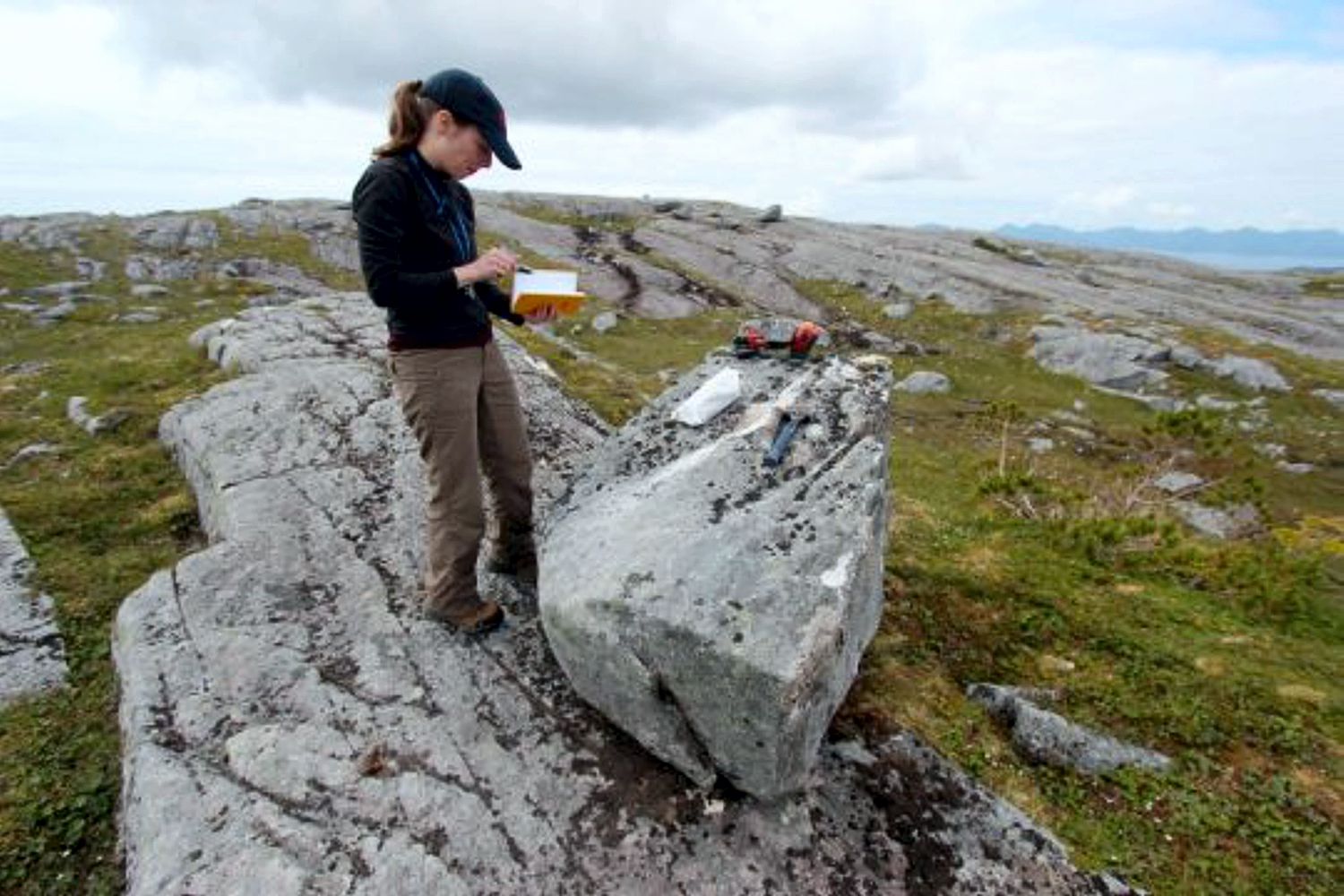
First People in the Americas – When? How? When and how did the first people come to the Americas? The conventional story says that the earliest settlers came via Siberia, crossing the now-defunct Bering land bridge on foot and trekking through Canada when an ice-free corridor opened up between massive ice sheets toward the end of the last ice age. But with recent archaeological evidence casting doubt on this thinking, scientists are seeking new explanations. One dominant, new theory: The first Americans took a coastal route along Alaska’s Pacific border to enter the continent. A new geological study provides compelling evidence to support this hypothesis. By analyzing boulders and bedrock, a research team led by the University at Buffalo shows that part of a coastal migration route became accessible to humans 17,000 years ago. During this period, ancient glaciers receded, exposing islands of southern Alaska’s Alexander Archipelago to air and sun — and, possibly, to human migration. The timing of these events is key: Recent genetic and archaeological estimates suggest that settlers may have begun traveling deeper into the Americas some 16,000 years ago, soon after the coastal gateway opened up. The research will be published online on May 30 in the journal Science Advances. “People are fascinated by these questions of where they come from and how they got there,” says lead scientist Jason Briner, PhD, professor of geology in UB’s College of Arts and Sciences. “Our research contributes to the debate about how humans came to the Americas. It’s potentially adding to what we know about our ancestry and how we colonized our planet.” “Our study provides some of the first geologic evidence that a coastal migration route was available for early humans as they colonized the New World,” says UB geology PhD candidate Alia Lesnek, the study’s first author. “There was a coastal route available, and the appearance of this newly ice-free terrain may have spurred early humans to migrate southward.” The findings do not mean that early settlers definitely traversed Alaska’s southern coast to spread into the Americas: The project examined just one section of the coast, and scientists would need to study multiple locations up and down the coastline to draw firmer conclusions. Still, the work is exciting because it hints that the seafaring theory of migration is viable. The bones of an ancient ringed seal — previously discovered in a nearby cave by other researchers — provide further, tantalizing clues. They hint that the area was capable of supporting human life at the time that early settlers may have been passing through, Briner says. The new study calculates that the seal bones are about 17,000 years old. This indicates that the region was ecologically vibrant soon after the ice retreated, with resources including food becoming available. Co-authors on the research included Briner; Lesnek; Charlotte Lindqvist, PhD, an associate professor of biological sciences at UB and a visiting associate professor at Nanyang Technological University; James Baichtal of Tongass National Forest; and Timothy Heaton, PhD, of the University of South Dakota. A landscape, touched by ice, that tells a story To conduct their study, the scientists journeyed to four islands within the Alexander Archipelago that lie about 200 miles south/southeast of Juneau. The team traveled by helicopter to reach these remote destinations. As soon as the researchers arrived, Briner knew that the islands had once been covered by ice. “The landscape is glacial,” he says. “The rock surfaces are smooth and scratched from when the ice moved over it, and there are erratic boulders everywhere. When you are a geologist, it hits you in the face. You know it immediately: The glacier was here.” To pinpoint when the ice receded from the region, the team collected bits of rock from the surfaces of boulders and bedrock. Later, the scientists ran tests to figure out how long the samples — and thus the islands as a whole — had been free of ice. The researchers used a method called surface exposure dating. As Lesnek explains, “When land is covered by a glacier, the bedrock in the area is hidden under ice. As soon as the ice disappears, however, the bedrock is exposed to cosmic radiation from space, which causes it to accumulate certain chemicals on their surface. The longer the surface has been exposed, the more of these chemicals you get. By testing for these chemicals, we were able to determine when our rock surfaces were exposed, which tells us when the ice retreated. “We use the same dating method for huge boulders called erratics. These are big rocks that are plucked from the Earth and carried to new locations by glaciers, which actually consist of moving ice. When glaciers melt and disappear from a specific region, they leave these erratics behind, and surface exposure dating can tell us when the ice retreated.” For the region that was studied, this happened roughly 17,000 years ago. The case for a coastal migration route In recent years, evidence has mounted against the conventional thinking that humans populated North America by taking an inland route through Canada. To do so, they would have needed to walk through a narrow, ice-free ribbon of terrain that appeared when two major ice sheets started to separate. But recent research suggests that while this path may have opened up more than 14,000 years ago, it did not develop enough biological diversity to support human life until about 13,000 years ago, Briner says. That clashes with archaeological findings that suggest humans were already living in Chile about 15,000 years ago or more and in Florida 14,500 years ago. https://youtu.be/CmxhFgpIacI The coastal migration theory provides an alternative narrative, and the new study may mark a step toward solving the mystery of how humans came to the Americas. “Where we looked at it, the coastal route was not only open — it opened at just the right time,” Lindqvist says. “The timing coincides almost exactly with the time in human history that the migration into
Waning Pleistocene Ice Sheet
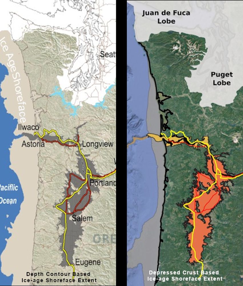
Waning Pleistocene Ice Sheet Affected Megaflood Paths and Local Shorelines Have you ever thought about the how the weight of the ice-age Cordilleran ice sheet might affect the underlying Earth’s crust? There is strong evidence that the crust was depressed hundreds of feet beneath the ice, and since the crust is relatively thin and rigid over a plastic aesthenosphere, that also caused the crust for some distance beyond the ice margins to tilt toward the ice sheet. A new modeling study explored how changes in topography due to the solid Earth’s response to ice sheet loading and unloading might have influenced successive megaflood routes over the Channeled Scablands between 18 and 15.5 thousand years ago. The modeling found that deformation of Earth’s crust may played an important role in directing the erosion of the Channeled Scabland. Results showed that near 18 thousand year old floods could have traversed and eroded parts of two major Channeled Scabland tracts—Telford-Crab Creek and Cheney-Palouse. However, as the ice-age waned and the ice sheet diminished 15.5 thousand years ago, crustal isostatic rebound may have limited megaflood flow into the Cheney–Palouse tract. This tilt dependent difference in flow between tracts was governed by tilting of the landscape, which also affected the filling and overspill of glacial Lake Columbia directly upstream of the tracts. These results highlight one impact of crustal isostatic adjustment on megaflood routes and landscape evolution. Other studies have shown that relative ice-age sea levels were over 300 feet lower worldwide due to the volume of water locked up in ice sheets. Typical depictions of the shoreface extent are generally based on a 300 ft. depth contour, but there is strong evidence that shorelines were up to 200+ ft. higher than present day in marine areas adjacent to ice sheets, again because the crust was depressed by the weight of the ice sheer. A more accurate representation might show a much narrower shoreface in ice-free areas nearer to the ice sheet margin. However, in the Haida Gwaii Strait at the margin of the ice sheet the lower thickness of the ice sheet meant that local shorelines were as much as 550 feet lower than they are today. This was because the much greater thickness of the center of the ice sheet served to push upwards areas at the edge of the continental shelf in a crustal forebulge. It is now widely thought that these emergent ice-free land areas might have provided a viable coastal migration corridor for early peoples making their way to the Americas from Asia during the Pleistocene.
First Peoples
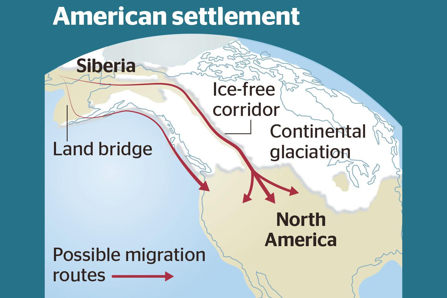
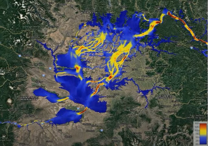
Ice-Free Corridor Human Migration to Americas R e e x a m i n e d Humans In Americas 30,000 years ago??? Analysis of how long erratics have been exposed on ice-free ground in the hypothesized “Late Pleistocene ice-free corridor migration route” suggests that route was not fully open until about 13,800 years ago. The ice sheets “may have been 1,500 to 3,000 feet (455 to 910 m) high in the area where they covered the ice-free corridor,” according to study lead author Jorie Clark, a geologist and archaeologist at Oregon State University. Clark said, “we now have robust evidence that the ice-free corridor was not open and available for the [Late Pleistocene] first peopling of the Americas.” If evidence of humans in the Americas prior to the 30,000 years ago is ultimately found, that evidence does not preclude the possibility of ice-free corridor migration before closure of the corridor.
The Grand Coulee – A Floods Poem
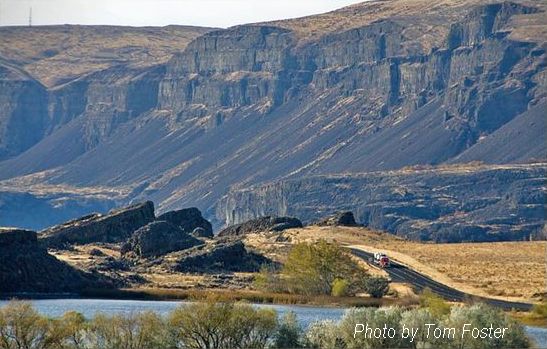
THE GRAND COULEE – A Floods Poem THE GRAND COULEE Older than legends,Younger than mountains,The earth remembersThe Great Inland Sea. And that Sea emptiedIn torrential furyNever imaginedEven in dreams. Down through the canyons,Flood of all riversCarving the couleesTime, time again. Roiled surging waters,Thunder of thunders,Swift toward the oceanReshaping the plain. Gone with the glaciersIs the great Lake Missoula,Gone from remembrance,Like mist in the wind. Yet the story is etchedIn the canyons and couleesLeft for those who imagineTo seek and to find. David Wahl January 4, 2002 Lower Grand Coulee Upper Grand Coulee at Steamboat Rock (left)
Trovants

Geology Can Be Weird – Trovants Trovants Are Stones That Seem to Grow, Move and Reproduce. By: Jennifer Walker-Journey | Jun 21, 2022 | HowStuffWorks/Science/Environmental Science/Earth Science/Geology/Geologic Processes Trovants such as these are found only in Romania and have become such a tourist attraction that they are protected by UNESCO. WIKIMEDIA COMMONS (CC BY SA 3.0)Just when we think we’ve seen it all, Mother Nature throws yet another oddity our way. Welcome to the wondrous world of the geological manifestations known as trovants. These rare bulbous, budging boulders are only found in a small town in Romania called Costesti. So fantastical are these trovants, they’ve found a place in local folklore. Some say they grow, walk and even give birth to baby trovants. Science says they’re probably right. What Are Trovants? Trovants are spherical and slightly irregular-shaped rocks. They can be as small as less than an inch, or a couple of millimeters, in diameter and weigh only a few grams, or they can soar up to 15 feet (4.5 meters) high and weigh several tons. These odd, gravity-defying boulders have baffled observers since the 18th century with many a curious soul suspecting they were dinosaur eggs, plant fossils or even alien pods. Scientists believed trovants to be a type of concretion — a mound of mineral matter (specifically gritstone and conglomerates) embedded within rock layers of limestone, sandstone or shale. They often form from minerals precipitating, or settling, out of water collected around a nucleus of pebble, leaf, shell, bone or fossil. However, in 2008, the International Geological Congress in Oslo claimed trovants were incorrectly classified as concretions because there was no mineral difference between the stones and the sandstone beds on which they sat. There was also no distinct nucleus inside them. Whatever they are, scientists believe that based on their makeup and locale atop the sands, these weird stones are older than man — shaped by earthquakes around 5.3 million years ago, during the Middle Miocene sub-epoch. The surrounding sands also suggest the area was an ancient marine environment, which may explain why bivalve and gastropod fossils can sometimes be found in them. These Rocks Can Grow and Multiply Another oddity about trovants — they secrete cement. This talent makes some people think they may be living creatures and not simply rocks. This cement seepage occurs after a heavy rain shower. When trovants absorb the rain’s minerals, the minerals come in contact with the chemicals already present in the stone, causing a pressure reaction that makes the rocks grow in girth. It’s not something you can see happening. Researchers say the deposition rate for trovants is roughly 1.5 to 2 inches (4 to 5 centimeters) every 1,000 years. This same phenomenon is what causes trovants multiply or “reproduce,” as some might say. When a new growth bauble emerges, likely from water affecting only one side of the rock, and gets big enough, it can break off from the “parent” rock and create baby trovants. Like a Rolling Stone Some people also believe that trovants can “walk,” much like the so-called sailing stones of Death Valley that appear to drift across the flat desert landscape on their own. One researcher allegedly filmed trovants for two weeks and claimed one moved about one-tenth of an inch (2.5 millimeters). While many academics are skeptical about “trovant walking” claims, they don’t deny the possibility that the heating or cooling of the soil could cause movement among the stones. Where Can I See a Trovant? Trovants are almost exclusively found in Romania’s Valcea County at the sand quarry near the Costesti village, along the Gresarea Brook, or in the neighboring Otesani village. To protect these unusual geological specimens, the “Muzeul Trovantilor” or Trovants Museum Natural Reserve, was developed in Valcea County, Romania, in 2004, and is now protected by UNESCO.
The Day the Dinosaurs Died
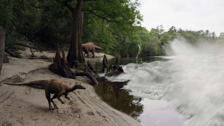
RETROPOLIS – Dave Kindy, Washington Post, May 9, 2022 Discoveries shed new light on the day the dinosaurs died The Thescelosaurus moved stealthily along the seashore. Stretching about 12 feet long and weighing about 500 pounds, the thickly muscled dinosaur was probably looking for food — or trying to avoid becoming a meal. Featuring prominent bony eyebrows and a pointy beak, Thescelosaurus plodded along on two feet with the bulk of its body leaning forward while a long tail stretched backward for balance. Suddenly, the dinosaur lifted its head and looked around, alarmed as the calm was broken by a series of unnerving natural forces. The ground started shaking with intense vibrations while water in the nearby sea sloshed about in response. The sky filled with burning embers, which drifted down and set fire to the lush primordial forest. Thescelosaurus panicked and looked to flee — but it was too late. Everything changed in a heartbeat as a 30-foot-high wave of mud and debris came racing up the seaway from the south, sweeping away life and limb in the process. The dinosaur was caught in the destructive deluge, its leg ripped off at the hip by the devastating surge. That moment — 66 million years ago at the end of the Cretaceous period, when an earth-shattering asteroid ended the reign of the dinosaurs — is frozen in time today through a stunning fossil found last year at the Tanis dig site in North Dakota. This perfectly preserved leg clearly shows the skin, muscle and bones of the three-toed Thescelosaurus. While the details of the death scenario described above are embellished, they’re based on remarkable new findings and accounts by Robert DePalma, lead paleontologist at Tanis. “We’re never going to say with 100 percent certainty that this leg came from an animal that died on that day,” the scientist said. “The thing we can do is determine the likelihood that it died the day the meteor struck. When we look at the preservation of the leg and the skin around the articulated bones, we’re talking on the day of impact or right before. There was no advanced decay.” DePalma and the dinosaur leg will be featured in two episodes of “Nova” on PBS airing back-to-back on Wednesday: “Dinosaur Apocalypse: The New Evidence” and “Dinosaur Apocalypse: The Last Day.” Biologist and natural historian Sir David Attenborough will host the programs, which were produced in conjunction with the BBC. The leg and several other relics discovered at the North Dakota site are the first actual fossils found showing the death and destruction that took place when a 10-mile-long space rock struck the Yucatán Peninsula in the Gulf of Mexico. This impact event 66 million years ago doomed the dinosaurs and led to the mass extinction of 75 percent of animal and plant life on Earth. At the time, the world was a much warmer place. There were no icecaps, and water levels were higher. The North American continent was split in two by the Western Interior Seaway. Tanis is located on what was the edge of that massive river, which became a conduit of carnage after the asteroid struck. The shock waves from nearly 3,000 miles away caused the seaway to erupt with a tsunami of epic proportions. As DePalma pointed out, Thescelosaurus never stood a chance. “You would not want to be there on that day,” he said. “There was a turbulent wall of death heading up the river. In addition, all these glowing spherules are falling out of the sky. They’re like beads of superheated glass reentering the Earth’s atmosphere after being ejected from the crater site at the Yucatán. Then there was all this seismic shaking. It was really hell on earth.” A dinosaur’s loss, though, is a paleontologist’s gain. After Tanis was discovered in 2008, scientists began to realize the fossils there were probably created during that big-impact moment. A series of key discoveries were made, including the dinosaur leg, the embryo of a pterosaur still in its shell, a turtle pierced by a chunk of wood and the well-preserved skin of a triceratops. Many of these fossils are being presented to the public for the first time in the PBS documentaries. Perhaps most telling were the fossilized fish unearthed at the site in 2019, which caught many scientists by surprise. In those petrified remains, researchers found the embedded evidence they needed to substantiate the claim that the animals died when the asteroid struck: the glass spheres, known as ejecta, that came raining down from the sky that fateful day. “Those were fish that died on that day,” DePalma said. “We know that because they had ejecta from the impact in their gills.” Researchers have unearthed countless samples of these glass spheres, all containing the signature chemical components typical of a major impact event. Made up of sand and other earthly materials, the molten glass was ejected into the atmosphere by the explosion caused by the asteroid striking the planet — estimated to be the equivalent of 10 billion atomic bombs. Inside one of those circular fossils is a tiny speck of rock that may be from the killer asteroid itself. DePalma, a postgraduate researcher at the University of Manchester in England and adjunct professor of geosciences at Florida Atlantic University, has headed efforts at Tanis since 2012. He and other scientists on the team have published several major papers describing the discoveries and outlining the scientific methodology used to date the fossils and other evidence. DePalma asserts that what happened then is directly relevant to the world today. “I’ve been asked, ‘Why should we care about this? Dinosaurs have been dead for so long,’ ” he said. “It’s not just for paleo nerds. This directly applies to today. We’re seeing mass die-offs of animals and biomes that are being put through very stressful situations worldwide. By looking through this window into the past, we can apply these lessons to today.” To produce the “Nova” episodes, DePalma worked directly with
Relive Important Archive Articles

A large number of important articles get buried over time as new articles are added to our website, so here’s a chance to review and relive some of our most important articles. We think you might enjoy reviewing these timeless features.
Hydraulic Modeling of a Missoula Flood
Chris Goodell’s 1-hour video presentation of his Ice Age Flood hydraulic modeling is both enlightening and thought provoking. Chris is a hydraulic modeling professional for Kleinschmidt Group, whose personal interest in the Ice Age Floods phenomenon led him to privately undertake HEC-RAS modeling of a possible Ice Age Flood hydraulic response. His presentation for American Society of Civil Engineers – Environmental & Water Resources Institute – Seattle (ASCE EWRI Seattle) provides interesting insights to the Floods Story even as it recognizes many of the obstacles and shortcomings of what we can know about details of any Ice Age Floods.
Scholars Trek on the Ice Age Floods Trail

Ice Age Floods Fourth Grade Curriculum Development One of the missions of the Ice Age Floods Institute is to educate young people about the Floods and the influence of the Floods on their lives today. The IAFI Educational Outreach Committee has contracted with the curriculum design firm The Inspired Classroom to produce engaging lesson materials to excite fourth-grade students from across the Northwest about the Ice Age Floods. The curriculum will contain video footage narrated by experts and lesson plans for use by fourth grade teachers in Montana, Idaho, Washington and Oregon. The story, entitled “Scholars Trek on the Ice Age Floods Trail,” will begin with a flyover video of the trail, including Glacial Lake Missoula, the Clark Fork Ice Dam, the Rathdrum Prairie, Spokane Falls, the Channeled Scabland, Lake Lewis, the Columbia River Gorge, Lake Allison, and the deposition of the eroded sediment on the continental shelf at the mouth of the Columbia River. Along the route, students will be introduced to the ways in which the Floods influence society today, including the influence of the Floods on the Spokane Aquifer and on railroad and highway routes across the Pacific Northwest. Funding for the project will come from grants, the IAFI, and from private benefactors. The continued support of IAFI members through membership dues and donations helps fund projects like this. The Education Committee is made up from a sampling of IAFI Board Members and Chapter Presidents from each state: Jim Shelden (Glacial Lake Missoula); Tony Lewis (Coeur du Deluge); Melanie Bell and Consuelo Larrabee (Cheney-Spokane); Gary Kleinknect (Lake Lewis) and Dale Lehman (Puget Lobe.) In the future, the Education Committee plans to work on curriculum materials for middle and high school students. By Dale Lehman, 04/14/2022
Explore the Columbia River Gorge
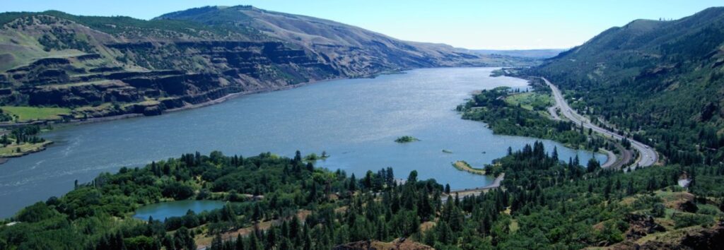
The Columbia River Gorge is an incredibly popular area to visit, and that’s for good reason, the setting is uniquely spectacular. The Gorge encompasses: Easily accessible ecozones that range through boreal conifer forests, oak woodlands, high desert grasslands and alpine environments in only 40 miles, Dazzling viewpoints and scenery, including beautiful waterfalls that cascade over the high basalt ramparts that bound the relatively narrow Gorge and the majestic Columbia River running through it, Mt. Adams, Mt. St. Helens and Mt. Hood, imposing snow-covered stratovolcanoes lying less than 40 miles north and south of the Gorge, Picturesque small towns that are bounded by extensive federally- and state-protected natural areas throughout the length of the Gorge, Abundant recreation opportunities including hiking, road/mountain biking, windsurfing and kiteboarding, whitewater kayaking and rafting, fishing, hunting, alpine/cross-country skiing and snowshoeing, Numerous award-winning wineries and breweries, restaurants and pubs, shops, galleries, museums, parks, hotels and campgrounds, And all this is lying at the back doorstep of Portland, Oregon. The Gorge is also a geologic wonderland, exposing stories about: The 40 million year history of the Columbia River, The series of massive Columbia River Basalt flows 18-12 million years ago, The rise of the Cascade Mountain Range since about 5 million years ago, The passage of numerous, up to 1000 feet deep Ice Age Floods that reshaped the Gorge 18-14 thousand years ago, Tectonic faulting and folding, landslides, earthquakes, forest fires, and The often intertwined lives and stories of the people who have lived here. Of course, with all this bounty the area is also a robust tourist mecca, which can mean limited accommodations for summer crowds. Most attractions are easy to drive to, but bus tours and river cruises are also available. Due to the popularity, some of the iconic attractions now seasonally restrict vehicle access and require permits.