
Glacial Lake Missoula
This feature-filled video by Tom Foster and Nick Zentner explores the evidence for Glacial Lake Missoula, and provides a treasure trove of places to visit and sights to see when you plan your field trip to the area.

This feature-filled video by Tom Foster and Nick Zentner explores the evidence for Glacial Lake Missoula, and provides a treasure trove of places to visit and sights to see when you plan your field trip to the area.

Balbas et. al. use cosmogenic beryllium-10 dating methods to further constrain the timing of ice sheet retreat, as well as the potential pathways for megafloods from both Lake Missoula and Lake Columbia. Read this fascinating Geology article summarizing their findings. Balbas2017 – Missoula Flood Chronology In summary, our new chronological information suggests the following: (1) Blockage of the Clark Fork river by the Purcell Trench lobe by ca. 18.2 ka, resulting in Missoula floods following the Columbia River valley. (2) Blockage of the Columbia River valley by the Okanogan lobe before 15.4 ± 1.4 ka, which shunted Missoula flood water south across the Channeled Scablands. (3) The final Missoula floods at ca. 14.7 ± 1.2 ka, signaling retreat of the Purcell Trench lobe from the Clark Fork valley, yet these floods entered a glacial Lake Columbia still impounded by the Okanogan lobe. (4) Down-Columbia floods at ca. 14 ka from breakouts of glacial Lake Columbia, signaling the retreat and final damming of the Columbia Valley by the Okanogan lobe

The Washington Geological Survey (formerly the Division of Geology and Earth Resources) has just released an ESRI story map about the Ice Age Floods in Washington. The story map: “tells the story of cataclysmic outburst floods that shaped the landscape of the Pacific Northwest during the last ice age. With imagery, maps and video, this story map follows the devastating deluge of the Missoula floods as it tore across the landscape, from its origins in western Montana to its terminus at the Pacific Ocean. Sites along the Ice Age Floods National Geologic Trail are featured, with an emphasis on flood features in Washington State.” Entitled Washington’s Ice Age Floods, it is best viewed on a desktop or laptop computer. Mobile devices will not show all of the content. It is navigated by scrolling your mouse through the slides. There are a few animated sections that may take a second or two to load. [weaver_iframe src=’https://wadnr.maps.arcgis.com/apps/Cascade/index.html?appid=84ea4016ce124bd9a546c5cbc58f9e29′ height=600 percent=100]
In September 2021 my wife and I took a trip to see what was new along the Ice Age Floods National Geologic Trail and visit some places we did not make it to in our very first trip in 2004. The IAFI chapter brochures were very helpful in learning what there was to see in each area. We also remembered a preview of the National Parks Service unigrid map brochure that will come out hopefully later this year, so be sure and get one when it debuts. The other excellent tool was the online interactive map on the Ice Age Floods Institute website (https://iafi.org/floodscapes/), where you can click on a spot and see a photo and description of the site. All are great planning tools. We drove to Missoula, Montana and stayed there a couple of days as we made day trips. Our first one was to Ovando to see a granite glacial erratic that the Glacial Lake Missoula Chapter had etched and placed at the high-water line. You will find it at Trixi’s Antler Saloon which is a nice place to grab a bite for lunch. The chapter has a number of these high water markers placed already and have more planned to show the full extent of Glacial Lake Missoula. Unfortunately, due to the smoke from the wildfires we were not able to go to Hamilton to see the 8-ton granite erratics outside Ravaili Museum with four interpretive signs outside and additional displays inside. We drove up to the Paradise Center in Paradise, Montana. We had been there before in 2016 for the fall IAFI field trip and they were just dreaming of what the old Paradise Elementary School could become. They have done a wonderful job of making that dream come true. It was one of our favorite spots on this trip. They have dedicated an entire room to the Ice Age Floods story where an extremely accurate 3-D map of Glacial Lake Missoula has lights installed so you can push a button to light up the edge of the ice lobe and other features. Besides information about the Ice Age Floods, the Center also has wonderful displays about the trains & train yard that used to be in Paradise and the history of the Paradise Elementary School. We went to the Natural History Museum in Missoula and enjoyed the panels and video which told the Lake Missoula Floods story and also about Joseph Pardee, a very important pioneer in solving the mystery of these Floods. This museum also displays an amazing amount of taxidermy showing the wildlife and birds in the region. On our way up to Sandpoint, Idaho we passed through Eddy Narrows. Glacial Lake Missoula drained through this canyon going 80 mph leaving horizontal marks high up on the walls. Previously these were thought to be glacial striations, but Pardee speculated that these marks were from huge boulders as they shot through the Narrows. The Narrows is long with few places you can pull over on Highway 200, so it can be hard to really appreciate its scope. We got a good view from the Koo-Koo-Sint Bighorn Sheep Viewing Interpretive Site which has several interpretive signs that talk about the sheep and the geology of the Clark Fork River Valley. We then went over to Farragut State Park at the southern tip of Lake Pend Oreille to view the beginning of the outburst plain that formed the Rathdrum/Spokane Valley aquifer. Across Lake Pend Oreille is Green Monarch Ridge; the terminus of the Purcell Trench which held the 4,000 ft. ice dam that carved the steep walls. The display at the museum has several interpretive panels. The next day we met Consuelo Larrabee who gave us a personal tour of the 40,000 square foot Ice Age Floods Playground in Riverfront Park in Spokane, Washington. She and Melanie Bell, the president of the Cheney-Spokane chapter, did an enormous amount of work as consultants on this fabulous, themed park. Kids can learn as they play on the three-story Columbian slide tower, Glacial Dam splash pad, log jam climber, an alluvial deposit fossil dig, and more. The park was filled with kids and the adults were enjoying it as much as the kids. We loved watching the excitement of a child as she saw the splash pad water fountains simulate the ice dam starting to rupture and then the cascade of water flooding over the manmade basalt rocks. Along the side of the building are actual basalt columns and the fossil dig led to many exciting discoveries by the children as they dug through the sand to reveal embedded replicas of fossils. Throughout the park are thoughtfully placed benches for people to sit and watch the fun going on around them. There are nine interpretive panels throughout the park adding a wonderful educational benefit to all the fun. This park will be quite a prize for years to come. The next day we drove along Highway 262 to W. McManamon Road to the Drumheller Channels National Natural Landmark. This outlet from the Quincy Basin, with floodwaters going 65 mph eroded not just the topsoil but the underlying basalt which created dramatic channels, basins, potholes and buttes. The viewpoints along the drive had several interpretive panels talking about these wonderful vistas. Since we live in Portland and this trip was to see places we had not recently seen, we skipped over the many wonderful places in the Columbia River Gorge, Willamette Valley & Tualatin. But for your trip, please check out the hundreds of beautiful and interesting sites to see in this region. The last stop for this trip was Cape Disappointment. The Floods debris flushing out the mouth of the Columbia River added substantially to submarine Astoria Fan and sediment cores have shown that ocean currents carried some of this debris all the way down to Cape Mendocino, California. Although not visible from the surface, the Park display has a relief map that shows the Astoria Canyon
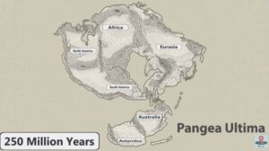
No one can ever say for sure what the future will bring, but this new video has summed up all the science-backed predictions that we can reasonably make about how Earth will change over the next 1 billion years. It’s highly unlikely that anyone will be around to see most of these changes come to pass, so consider this an exclusive front-row seat to a world where supercontinents reign supreme, Mount Everest is no longer the tallest mountain on our planet, Earth enters another glacial period regardless of current global warming trends. and then the Sun becomes a lot hotter. Just another reason we should be glad we live at the time we do. Reposted from Science Alert and RealLifeLore
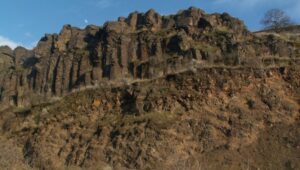
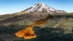
Pillow basalt and palagonite are the result of lava flowing into water. We have a striking example in the Columbia River Gorge at the intersection of Hwy 30 and US 197 at the east end of The Dalles. This video gives a good idea of how these basalt pillows form and what they look like.
Floods of lava (Columbia River Basalts) and Ice Age Floods of water (Lake Missoula floods and the Bonneville Flood) are world-famous topics among geologists. To have both sets of floods in the same area means the geology of the Inland Northwest is truly Disneyland for Geologists! The program begins in Lewiston, Idaho where the floods of lava and water are beautifully on display near the mouth of Hells Canyon. Early on, the Columbia River Basalts – eruptions of fluid lava from deep fissures – are featured. The Missoula Floods from Montana and the Bonneville Flood from Utah – the Ice Age Floods – are surveyed at an introductory level. And finally, the interaction between bedrock and fluid dynamics of the floodwater are highlighted through discussion of Ice Age erosional and depositional landforms. Key locations in the Pacific Northwest are featured, including the Snake River Canyon, Grand Coulee, Dry Falls, the Drumheller Channels, Wallula Gap, and the Columbia River Gorge. Tom Foster and Nick Zentner (Central Washington University) had been hiking together in eastern Washington for years. The result? A series of short videos that showcase geological wonders in the Pacific Northwest. This 16-minute video – Huge Floods in the Pacific Northwest – offers an introductory overview of spectacular geologic events that impacted much of Washington, Oregon, and Idaho. More than a dozen “2 Minute Geology” episodes are now available on Nick’s 2-Minute Geology YouTube channel.

The Glacial Lake Missoula chapter has worked with Inspired Classroom LLC to produce a series of 9 short (3-7 minute) videos exploring different aspects of the Ice Age Floods in the Glacial Lake Missoula area. The entire set is posted to the Inspired Classroom LLC YouTube channel, including a full 31 minute version (below) that compiles the entire set.

An ancient flood seems to have stalled the circulation of the oceans, plunging the Northern Hemisphere into a millennium of near-glacial conditions. Thirteen thousand years ago, an ice age was ending, the Earth was warming, the oceans were rising. Then something strange happened – the Northern Hemisphere suddenly became much colder, and stayed that way for more than a thousand years. For some time, scientists have been debating how this major climatic event – called the “Younger Dryas” – happened. The question has grown more urgent: Its answer may involve the kind of fast-moving climate event that could occur again. This week, a scientific team made a new claim to having found that answer. On the basis of measurements taken off the northern coasts of Alaska and Canada in the Beaufort Sea, the scientists say they detected the signature of a huge glacial flood event that occurred around the same time. This flood, they posit, would have flowed from the Arctic into the Atlantic Ocean and shut down the crucial circulation known as the “Atlantic meridional overturning circulation” (or AMOC) – plunging Europe and much of North America back into cold conditions. “Even though we were in an overall warming period, this freshwater, exported from the Arctic, slowed down the vigor, efficiency of the meridional overturning, and potentially caused the cooling observed strongly in Europe,” said Neal Driscoll, one of the study’s authors and a professor at the Scripps Institution of Oceanography. The work, published in Nature Geoscience, was led by Lloyd Keigwin of the Woods Hole Oceanographic Institution along with researchers at that institution, Scripps and Oregon State University. The result remains contested, though, with other researchers still arguing for different theories of what caused the Younger Dryas – including a very differently routed flood event that would have entered the ocean thousands of miles away. Nonetheless, the story is relevant because today, we’re watching another – or rather, a further – deglaciation, as humans cause a warming of the planet. There is also evidence that the Atlantic circulation is weakening again, although scientists certainly do not think a total shut-off is imminent, and are still debating the causes of what is being observed. Either way, the new research underscores that as the Earth warms and its ice melts, major changes can happen in the oceans. And could happen again. The researchers behind the current study, working on board the U.S. Coast Guard Cutter Healy, analyzed sediments of deep ocean mud, which contain the shells of long-dead marine organisms called foraminifera. In those shells, the scientists detected a long-sought-after anomaly recorded in the language of oxygen atoms. The shells contained a disproportionate volume of oxygen−16, a lighter form (or isotope) of the element that is found in high levels in glaciers. That is because oxygen−16, containing two fewer neutrons and therefore lighter than oxygen−18, evaporates more easily from the ocean but does not rain out again as readily. As a result, it often falls as snow at high latitudes and is stored in large bodies of ice. “This is the smoking gun for fingerprinting glacial lake outbursts,” Driscoll said. And that means the findings may also represent the trigger for the Younger Dryas. The thinking is that as the ice age ended and the enormous Laurentide ice sheet atop North America began to retreat, the resulting meltwater fed a bevy of large lakes atop the depressed surface of the continent. That included the massive glacial Lake Agassiz, which stretched from the Great Lakes northwestward across much of Canada. The approximate maximum extents of major glacial lakes that formed from the retreat of the western Laurentide Ice Sheet. (Shannon Klotsko, Scripps Institution of Oceanography, University of California at San Diego) Prior research had shown that for a while, much of the resulting freshwater drained down the Mississippi River and into the Gulf of Mexico. But at some point, as the ice sheet continued to shrink, the flow of water appears to have been suddenly rerouted to the north or to the east, where it could do more potential damage to the ocean circulation in the Atlantic. There has long been scientific debate about where all the meltwater actually entered the ocean, though – with some contending that it would have occurred through the St. Lawrence River, which flows past today’s Montreal and Quebec City and thus out into the Atlantic. The new research holds that, instead, the floodwater exited through the Mackenzie River, which stretches across today’s Northwest Territories, emptying straight into the Arctic Ocean. It would certainly have been an enormous flow of fresh water. “I would say somewhere between the Mississippi and the Amazon,” Keigwin said. That could have interfered with the Atlantic circulation, which is crucial because it carries warm water northward, and so heats higher latitudes. Eventually, the waters of the circulation become very cold as they travel northward, but because they are also quite salty, they sink because of their high density and travel back south again. Freshening is therefore the Achilles’ heel of the circulation. And the new study argues that although the glacial water would have entered the seas very far away near the present Alaska-Canada border, it would have then circulated around the Arctic, eventually traveling south past Greenland and entering the key regions that are crucial to the overturning circulation, which tend to be off Greenland’s southern coasts. Not everyone is convinced, though – including some researchers who have previously published results suggesting that the outburst flood or flow was instead to the east, through the St. Lawrence River. “They have produced a nice signal of the release of freshwater into the Arctic Ocean, but the conclusions are based on an uncertain chronology which, when trying to tie together events so closely, requires some independent confirmation,” Peter Clark, an Oregon State University geoscientist who has published evidence supporting the St. Lawrence River theory, said in an email. Anders Carlson, Clark’s co-author and colleague at Oregon State University, sent a geological study finding that, as he put

“Beneath Our Feet: Mapping the World Below” plumbs the depths of the question, “What’s beneath our feet?” through maps, images and archaeological artifacts. The exhibition explores nearly 400 years of maps and objects in an attempt to find out why and how humans imagine subterranean landscapes including caves, mines and water tables. Colorful and complicated images reflect the biases of long past and recent days and the concerns of their authors, including the United States’ desire to appropriate the natural resources of Native American lands and a 17th-century Jesuit priest’s attempt to use Scripture to create a framework for Earth’s geology. Catch the exhibition online, including a bibliography, reading lists and a 3-D tour of the Boston Public Library’s Norman B. Leventhal Map Center gallery itself. As you explore nearly 400 years of maps and images of the world below, you can compare the historical viewpoint with the modern, and see how we have advanced our perception and depiction of what lies beneath.

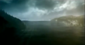
In this video Tom Davis flies you back some 13,000 years ago to see and hear what the landscape of Glacial Lake Missoula might have looked and sounded like. A virtual recreation of the magical ice-age lake and its catastrophic floods. Produced by Tom Davis, GLM Wine Company, Blaine, WA minutes)
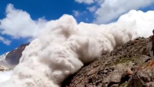
On Friday,July 8 around 2:45 p.m., British tourist Harry Shimmin reached the highest point in his trek along the Jukku pass in the Tian Shan mountains in Kyrgyzstan. He separated from the group to take pictures from the edge of a cliff when he heard deep ice cracking behind him. He turned around to an avalanche of glacial ice and snow rushing toward him and within moments found himself in a blizzard. The avalanche was the second glacier collapse of the week, demonstrating the perils of human-caused climate change amid a blistering hot summer in parts of Europe and Asia. These are glacier ice avalanches, rather than primarily snow, in which a glacier broke off and collapsed under the force gravity. The high density of ice added speed and weight to the avalanche. In the Tian Shan event, glaciologist Peter Neff, of the University of Minnesota, pointed out that there was no apparent snow around the mountain so the avalanche was largely a solid chunk of glacial ice. In high mountain regions with permafrost, warm temperatures not only destabilize the glacier ice but also the density of the ice around it. “It’s very dense, more like a landslide than an avalanche,” he said. “The British trekker is indeed, as he is aware, very lucky to be alive in the case of the Kyrgyzstan event,” added glaciologist Jeff Kargel, a senior scientist at the Planetary Science Institute. “A pretty solid hypothesis is that as temperatures warm [and] climate warms, the amount of melting increases,” Kargel said. “The effects of meltwater on destabilizing ice masses increases, and so the number, the frequency and magnitude of glacier ice avalanches should be increasing … and that does seem qualitatively to be the case.” Daniel Farinotti, a glaciologist at ETH Zurich, agreed. “It is long known that meltwater caused by high temperatures increase the pressure in the glaciers’ subglacial drainage system, which in turn can accelerate glacier motion,” said Farinotti in an email. “This increase in pressure and motion have certainly a role to play in such collapses.” Among the greatest downstream effects from such mountain glacier loss and collapses are on fresh water systems, Neff said. For instance, glaciers in High Mountain Asia play a critical role in funneling freshwater into river basins used for drinking, irrigation and hydropower by nearly 1.5 billion people. From the Washington Post article by Kasha Patel
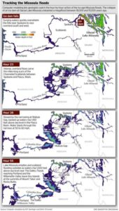
ICYMI (in case you missed it) — Floodwaters rise more than 1,000 feet as they slam into the Columbia River Gorge from the east. The torrent blasts through the narrows at 60 mph, carrying truck-size boulders and house-size icebergs. Reaching Portland, water loaded with gravel and dirt roils to a depth of 400 feet, leaving tiny islands at the summits of Mount Tabor and Rocky Butte. Geologists have spent decades piecing together evidence to tell the story of the great Missoula floods that reshaped much of Oregon and Washington between 18,000 and 15,000 years ago. Now scientists have found a way to travel back in time to watch the megafloods unfold, in a virtual bird’s eye view. Their computer simulation displays the likely timing and play-by-play action, starting with the collapse of an ice dam and outpouring of a lake 200 miles across and 2,100 feet deep. The computer model, developed by Roger Denlinger with the U.S. Geological Survey in Vancouver and Colorado-based geophysicist Daniel O’Connell, is filling gaps in scientific explanations of the floods and the baffling landforms they left, including the fabled Channeled Scablands — scars hundreds of miles long cut into the bedrock of eastern Washington and visible from outer space. The simulations also may help settle a lingering scientific controversy about what caused the repeating ice-age catastrophes. “It’s just really powerful visualization that gives a sense of the scale of the floods, how they came down through the channel system and backed up the big tributary valleys,” said Jim O’Connor, a hydrologist with the U.S. Geological Survey in Portland who has written extensively on the Missoula floods. He said the modeling work provides the first “really good information” on the timing of events. During the last ice age, a continent-spanning ice sheet built from massively expanded glaciers descended from the Canadian Rocky Mountains to reach deep into Washington, Idaho and Montana. Glacial Lake Missoula formed behind a miles-long dam of ice across what is now the valley of the Clark Fork and Pend Oreille rivers running from Montana to northeast Washington. The dam formed and collapsed dozens of times over a span of three thousand years. In the simulation of one of the largest possible floods, raging water quickly overwhelms the hills near Spokane and races overland to the south and west. The intense, overland flows carve the miles-long scars of the scablands between Spokane and Pasco, Wash. Thirty-eight hours later, swirling, mud-darkened waters converge at the narrowing of the Columbia at Wallula Gap, where the backed-up flow rises 850 feet above river level (1,150 feet above sea level). An immense volume of water blasts through the narrows at fire-hose velocity. Flow exceeds 1.3 billion gallons per second — a thousand times greater than the Columbia’s average flows today. Lake Missoula’s water, all 550 cubic miles of it, drains in 55 hours — less than three days — according to the model. At that time, the flood surge peaks in the Columbia Gorge at The Dalles, rising 950 feet above river level (1,000 feet above sea level), spilling over the gorge walls in places, and flooding the valleys of tributaries for miles upstream. Inundation of the Willamette Valley peaks on the seventh day after dam burst, in the simulation. Flooding reaches as far south as Eugene. Loaded with mud and gravel, the flood dumps sediment across the entire valley. Repeated floods build a layer 100 feet thick in Woodburn. Such a vast inundation, far greater than anything ever witnessed in historical time, seemed impossible to geologists in the 1920s, when J Harlen Bretz proposed that the scablands resulted from a catastrophic flood, not eons of gradual erosion. The idea didn’t gain mainstream acceptance until the 1960s. Since then, geologists have found evidence that Lake Missoula emptied catastrophically dozens of times during the last ice age. But controversy persists. A few scientists assert that the cataclysmic floods must have had multiple sources, not just an outburst from Lake Missoula. John Shaw of the University of Alberta in Edmonton, for instance, has proposed that an enormous reservoir beneath the ice sheet over much of central British Columbia boosted the flooding. The new simulation suggests that discharge from Lake Missoula alone would have been powerful enough. The simulated flood reaches peak stages all along its route that match the evidence visible today in sediment, with one big exception: At Wallula Gap, water levels in the simulation fell short by as much as 130 feet. “It’s pretty clear, if Lake Missoula is enough to hit all the other high water marks, you don’t need another source of water,” Denlinger said. Calculating the convoluted paths of such a massive flood requires an immense amount of number crunching. Simulating one flood requires more than 8 months of computer time, Denlinger said. But the computer simulation isn’t likely to end the debate. The fact that it can’t reproduce the maximum flooding at Wallula Gap leaves room for doubts. And some experts say there is direct evidence for an additional source of flood waters from beneath the ice sheet that covered the Okanagan Valley. “It is conceivable that other valleys in southern British Columbia contributed water to the scablands but the field evidence necessary to test these possibilities has not been fully documented,” said earth scientist Jerome-Etienne Lesemann at the University of Aarhus in Denmark. “There are a number of unanswered questions,” he said. “That makes the whole Channeled Scablands story a really interesting and intriguing geological puzzle.” Reprinted from The Oregonian, original article by Joe Rojas-Burke, 2010

Frenchman Coulee Ice Age Floods National Geologic Trail Frenchman Coulee is a short drive north and west from the Silica Road exit 123 off US-90, along the Old Vantage Road. It is one of the most beautiful features left behind by the great Ice Age Floods. Several of those massive floods, up to 700 ft (213 m) deep, created Frenchman Coulee, its Potholes Coulee neighbor to the north, and scoured the bizarrely eroded surface of Babcock Bench, preferentially eroding weaker rock out of the top of the Grand Ronde Member of Columbia River Basalt. Frenchman Coulee is actually a dual coulee and cataract system, Frenchman Coulee and Echo Basin, separated by a remnant rock blade that sports tall basalt columns attracting rock climbers like bees to flowers. The Feathers is probably the most popular climbing area in the region. Hiking trails, some barely discernible, lead along and atop the rock blade, affording spectacular views of both coulees. Frenchman Coulee also has a waterfall in the eastern section of the Coulee that is accessible by foot. Other hiking and biking trails explore the floor of the coulee and continue over 15 miles north along Babcock Bench, perched high above and adjacent to the Columbia River, past Potholes Coulee and on to Crescent Bar. Quick Facts Location: Old Vantage Highway, Quincy, WA 98848 A primarily destination for hikers, mountain bikers and rock climbers with the fascinating rock formations of the Gorge making for a great challenge

An interesting, 4 minute captioned video from UC Santa Cruz (ingomar200) of a satellite-view computer simulation illustrating flood paths and transient lakes of an Ice Age Flood. The video shows a physics-based computer simulation of the Great Flood from Glacial Lake Missoula about 15,000 years ago. At the time, an ice dam blocked the Clark Fork River near the Idaho-Montana border and backed up a lake about equal in volume to Lake Huron. When the ice dam broke a cataclysmic flood scoured much of central Washington State leaving a vast region covered with erosional remnants.
The Washington Geological Survey (WGS) has released 50 high-resolution lidar-derived images of the State’s geology and geomorphology through the Washington State DNR’s Flickr page. The images are available in 16:9 format (7,200 x 4,050 pixels) and 4:3 format (7,200 x 5,400 pixels). Ten of the images are new (see below) and 40 of them were previously available as screen wallpaper (at a lower resolution). Additionally, WGS has released several full-resolution lidar image series that reveal the State’s geology. These images are great for earth science presentations, learning about lidar, and for using as digital wallpaper. They are also large enough to support large-format printing. Here are direct links to the image galleries:

This episode of Grant’s Getaways features Lower Columbia President Rick Thompson and the Floods-borne erratics of the Willamette Valley
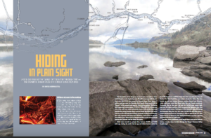
Millions of people who visit and pass through the Gorge each year don’t realize the scope of the cataclysmic stories behind the stunning and tranquil beauty they are surrounded by. The Spring 2019 edition of The Gorge Magazine (page 50) attempts to address that premise with a feature article about the geology of the Columbia River Gorge titled “Hiding in Plain Sight“. The author, Gregg Harrington, who is not a geologist, used a private tour with Lloyd DeKay, president of the Columbia River Gorge Chapter, as well as other local geologists as a basis for much of the article. The article touches on 40 million years of Gorge geology, including the Ice Age Floods, and highlights some of the more interesting geological features of this popular tourist destination. Hopefully, articles like this, along with IAFI field trips, lectures and website, will help many recognize and realize some of the tumultuous story that lies behind the enchanting scenery, and make them “never see the Gorge in the same way again”. The magazine is available online and begins at page 50. We had hoped for an Ice Age Floods Institute website mention, but a planned “For more information” section was not included in the article. Still, the article covers a lot of interesting geology of an extremely popular destination, and an article like this is a significant contribution to our efforts to inform and educate the public about the Ice Age Floods.

Lake Missoula filled many times and emptied catastrophically in many Missoula Floods. Rhythmite sequences [a series of repeated beds of similar origin] at numerous localities provide this evidence: slack-water rhythmites in backflooded tributary valleys below the dam indicate multiple floods, and varved rhythmites in Lake Missoula attest to multiple fillings of the lake. Below the dam, most slack-water rhythmites are graded beds deposited by flood bores surging up tributary streams. They grade upward from coarse sand and gravel to silt, with occasional ice-rafted erratics. The tops of some rhythmites are marked by thin paleosols, or buried soil horizons, which indicate a period of subaerial exposure. Thus, each rhythmite represents a separate flood event, and each deposit records multiple floods. The most complete record occurs at Sanpoil Valley, an embayment on the north side of Lake Columbia, where varved rhythmites document 89 flood events, with the period of time between floods initially increasing to a maximum of about 50 years and then decreasing to less than 10 years. Thousands of varves were deposited in Lake Missoula. At the best-known Ninemile locality near Missoula, about 40 rhythmites consist of varves overlain by a sand/silt layer. The varves were deposited on the floor of Lake Missoula, and the sand/silt layers represent subaerial exposure and deposition in a stream. The number of varves in each rhythmite varies from 9 to 40, decreasing regularly upward, and the total number of varves is just less than one thousand. An interpretation of these data would suggest: [1] Lake Missoula filled and emptied [in a catastrophic flood] about 40 times, [2] it took 9 to 40 years to fill the lake, each successive lake requiring less time, and [3] the process was repeated over a period of about one thousand years. Because Ninemile is about in the middle of the very long lake, the record here would not provide a complete history of the lake. Correlating Ninemile with the downstream record would suggest these events were in the latter half of the entire flood history.
This year’s IAFI June Jamboree delved into the fascinating geological history of Spokane Valley, contrasting it with the iconic Grand Coulee and Dry Falls, explored during last year’s Jubilee. Challenging the Landscape: Unlike the open spaces of Dry Falls, Spokane Valley presented a unique challenge – showcasing evidence of Ice Age Floods within an urban environment. Our chapter tackled this brilliantly, organizing hikes and car caravans departing from convenient public parks and commercial areas. Evening Explorations: The program’s highlights included captivating lectures. Professor Emeritus Dean Kiefer shed light on J Harlen Bretz’s Spokane associates, while renowned naturalist Jack Nesbit brought the story of the first Columbian Mammoth discovered near Latah Creek in the 1800s to life. Celebrating Success: The Jamboree culminated in a relaxed gathering at Mirabeau Meadows. Registrants, leaders, and participants exchanged insights and experiences, with a resounding appreciation for the chapter’s efforts. Comparisons were drawn, highlighting how our Spokane Valley exploration continued the excellence of the Puget Lobe’s outing at Dry Falls last year. A Delicious Finale: The grand finale was a catered Longhorn Barbecue overflowing with delicious food. Everyone left satisfied, with many even taking home doggie bags to savor the flavors afterward. Check out more images from the event in this Google Photo Album. Meet the Masterminds: Linda & Mike McCollum: This dynamic professor emerita and a research geologist duo co-led tours and car caravans, sharing their latest research on the Spokane area’s Ice Age Floods, and shaping the Jamboree’s theme. Michael Hamilton: A gifted geologist, Michael led hikes and the bus trip, encouraging questions and offering honest answers. Don Chadbourne & Chris Sheeran: Don, the chapter treasurer, managed logistics with expertise, while Chris, our media and registration guru, ensured a smooth experience. Melanie Bell Gibbs: A past president and national board member, Melanie oversaw participant check-in and badge distribution. Dick Jensen: Dick handled bus transportation and provided crucial support throughout the Jamboree. Jim Fox: The chapter vice president secured speakers and offered his assistance wherever needed. We also owe a great deal to the participant volunteers who proved invaluable in assisting us in all our efforts. Through the combined efforts of many the IAFI June Jamboree was a resounding success, fostering exploration, education, and a deeper appreciation for the Spokane Valley’s unique geological heritage. Being present with so much information and conversation among such extensive expertise was to witness the scientific process in action. Meeting people from other chapters was particularly nice, putting faces with names we know. We all learned a lot.
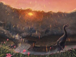
Spring may have been when a roughly seven-mile-wide asteroid struck the Earth, immediately triggering the mass extinction that would wipe out 76 percent of known species. That key piece of timing doesn’t come from dinosaurs, but from the fish that swam in the waters dinosaurs drank from. By studying the fossil bones of these fish and comparing them to their modern counterparts, Vrije Universiteit Amsterdam paleontologist Melanie During and colleagues have come to the conclusion that the impact that ended the Age of Dinosaurs most likely occurred in the spring. Like their modern counterparts, ancient sturgeons and paddlefish of the Hell Creek Formation, found in the “Tanis” fossil site in North Dakota, grew in cycles. Those researchers proposed that this place contains critical clues about the first minutes and hours of what transpired after impact—including well-preserved fossil fish that contain asteroid impact debris in their gills. During warmer months when food was plentiful, the ancient fish grew and added more bone tissue just as their modern relatives do. During cooler, harsher months, however, their growth slowed and left a line—called a line of arrested growth, or LAG—in their bones. In addition, the bones of these fish contained signatures from oxygen and carbon isotopes. The geochemical signals in these isotopes were influenced by what the fish were eating and the waters they swam in, a natural phenomenon that has been used by paleontologists to study everything from when early whales took to the seas to what plants ancient herbivores ate. Details of the prehistoric sturgeon and paddlefish bones indicate that these fish had not yet hit the peak of their annual growth spurt, which would be expected during the warmest parts of the year. The carbon isotope ratios in the paddlefish bones also match up with this pattern. If these ancient fish lived according to a similar annual cycle as their living relatives, then the signatures in their bones hint that they perished in spring. The fact that tiny spherules thrown into the air during the impact were found in their gills places the time of death within minutes or hours of the end-Cretaceous impact. Together, these lines of evidence suggest that the impact took place while the Northern Hemisphere was in spring and the Southern Hemisphere was still in winter. Read more in the Smithsonian Magazine article by Riley Black that this was taken from, or a Science Alert article that also recaps the paper published in Nature.

Have you ever thought about the how the weight of the ice-age Cordilleran ice sheet might affect the underlying Earth’s crust. There is strong evidence that the crust was depressed hundreds of feet beneath the ice, and since the crust is relatively thin and rigid over a plastic aesthenosphere, that also caused the crust for some distance beyond the ice margins to tilt toward the ice sheet. A new modeling study explored how changes in topography due to the solid Earth’s response to ice sheet loading and unloading might have influenced successive megaflood routes over the Channeled Scablands between 18 and 15.5 thousand years ago. The modeling found that deformation of Earth’s crust may played an important role in directing the erosion of the Channeled Scabland. Results showed that near 18 thousand year old floods could have traversed and eroded parts of two major Channeled Scabland tracts—Telford-Crab Creek and Cheney-Palouse. However, as the ice-age waned and the ice sheet diminished 15.5 thousand years ago, crustal isostatic rebound may have limited megaflood flow into the Cheney–Palouse tract. This tilt dependent difference in flow between tracts was governed by tilting of the landscape, which also affected the filling and overspill of glacial Lake Columbia directly upstream of the tracts. These results highlight one impact of crustal isostatic adjustment on megaflood routes and landscape evolution. Other studies have shown that relative ice-age sea levels were over 300 feet lower worldwide due to the volume of water locked up in ice sheets. Typical depictions of the shoreface extent are generally based on a 300 ft. depth contour, but there is strong evidence that shorelines were up to 200+ ft. higher than present day in marine areas adjacent to ice sheets, again because the crust was depressed by the weight of the ice sheer. A more accurate representation might show a much narrower shoreface in ice-free areas nearer to the ice sheet margin. However, in the Haida Gwaii Strait at the margin of the ice sheet the lower thickness of the ice sheet meant that local shorelines were as much as 550 feet lower than they are today. This was because the much greater thickness of the center of the ice sheet served to push upwards areas at the edge of the continental shelf in a crustal forebulge. It is now widely thought that these emergent ice-free land areas might have provided a viable coastal migration corridor for early peoples making their way to the Americas from Asia during the Pleistocene.

Chris Goodell’s 1-hour video presentation of his Ice Age Flood hydraulic modeling is both enlightening and thought provoking. Chris is a hydraulic modeling professional for Kleinschmidt Group, whose personal interest in the Ice Age Floods phenomenon led him to privately undertake HEC-RAS modeling of a possible Ice Age Flood hydraulic response. His presentation for American Society of Civil Engineers – Environmental & Water Resources Institute – Seattle (ASCE EWRI Seattle) provides interesting insights to the Floods Story even as it recognizes many of the obstacles and shortcomings of what we can know about details of any Ice Age Floods.
Ice Age Floods Smithsonian Article Devastating Ice Age Floods That Occurred in the Pacific Northwest Fascinate ScientistsThe Scablands were formed by tremendous and rapid change, and may have something to teach us about geological processes on Marsby Riley Black – Science Correspondent – April 19, 2022 for Smithsonian Magazine The Earth seems to change slowly. Continents shift by about half an inch in a year. Sea levels rise by less than a quarter of an inch in the same amount of time. Mountains are constantly being eroded but, to us, seem to stand today just as they did yesterday and the day before. Our planet’s geological history often seems like one of slow, grinding change. But that’s hardly the whole story. Sometimes geological change comes startlingly, violently fast, leaving scars on the Earth’s surface. The Channeled Scablands of the Pacific Northwest, a landscape full of flat-topped plateaus that rise between steep-walled canyons, are among the vastly-altered landscapes that have caused researchers to rethink what they previously presumed. The geologic wounds are dramatic evidence that quick and catastrophic changes have played a significant role in shaping our planet. The Scablands, principally located in southeastern Washington state, bear the signs of an incredible Ice Age event. Between 14,000 and 18,200 years ago, huge glacial lakes on the boundaries of ice sheets burst from their natural dams and rushed over the landscape, scouring the hills and dropping massive stones as they went. Entire hills were washed away as the floodwaters dumped gravel, boulders and sediment in new places, almost like shaking a great geological Etch-a-Sketch. But this is a relatively new understanding, only broadly accepted since the 1970s. It took decades for geologists to construct even an outline of what the Scablands represent, a realization that proved to be a turning point for science. For if intense floods could carve such features once in Earth’s history, surely they could have changed landscapes at other times and in other places—even those as far away as the Martian surface. Geologists only began to pick up on the story of the Scablands a century ago. In the 1920s, naturalist J Harlen Bretz wrote several descriptive papers on the strange basins and odd channels of the area. Those channels had been created by moving water, but the way water had once flowed through the area seemed to make no sense. “The channels run uphill and downhill, they unite and they divide, they head on the back-slopes and cut through the summit,” Bretz wrote, “they could not be more erratically and impossibly designed.” The only reasonable conclusion, Bretz proposed, was that the Scablands were created by massive and short-lived floods. Bretz’s colleagues were not ready for such a conclusion. Ever since geology came into its own as a science in the 19th century, much of the field has been influenced by the concept of uniformitarianism—that the present is the key to the past. In a broad sense, that’s an excellent rule. The Earth is still changing, and many of those alterations—from erosion to volcanic eruptions—also occurred in the past. But some additional stipulations to the older formulation of the idea were unnecessarily taken as truth. One of them was that the Earth is changing at a slow, gradual rate and that quick, catastrophic change was impossible. Bretz’s idea for how the Scablands formed flew in the face of what many geologists accepted. Channels were carved over long periods of time by rivers, other geologists thought, not by sudden floods. To Bretz, the evidence was unmistakable. Among other things, the Scablands contained layers of gravel hundreds of feet high. Slow-moving streams couldn’t have left such vast accumulations. Pieces of gravel are larger and heavier than particles of sand or silt, requiring faster-moving water to pick up the gravel and transport it. Gravel deposits as tall as skyscrapers must have required an incredible amount of fast-flowing water. The pattern was consistent with the underlying geology of the area, as well. The rock beneath the massive flood deposits was relatively friable volcanic rock, easily broken and carved. The fragility of these rock layers allowed the floods to gouge out channels and canyons in a way that harder rocks would have been more resistant to. Yet the fact that Bretz couldn’t identify the source of the floodwaters caused many to dismiss his idea, and it wasn’t until evidence of similar events—such as Ice Age flood beds found in Montana—that other experts began to reconsider what Bretz had proposed. Eventually, by the 1970s, dismissive geologists changed their tune. Something catastrophic truly did transpire to create the Scablands. Not that the behavior or history of such floods are completely understood. “There are loads of outstanding questions and many people are thinking carefully about the Scablands,” says University of Washington geology PhD candidate Kelsay Stanton. Even though experts are confident that vast glacial lakes provided the water for the floods, the precise volumes of the repeated floods are unknown, and the timing of the dozens of outbursts has yet to be determined in detail. “The glacial outburst flooding of the Pacific Northwest is hardly a closed subject,” Stanton says. Part of what’s allowing geologists to keep going back to the Scablands is that the tools available to scientists have changed a great deal since Bretz’s time. “There are lots of geochronology and computer modeling methods now that weren’t available when Bretz and other early researchers were mapping the area,” says University of Massachusetts Amherst geology PhD candidate Karin Lehnigk. These repeated floods affected the ocean, she notes, with the influx of freshwater reducing the saltiness of the northern Pacific for years and altering the way colder, saltier water in deep ocean layers circulated. The floods affected more than the land they ran over, and have acted as models for how our modern glaciers might alter ocean circulation as they melt due to global warming. New, broad scale methodologies can offer some of these insights and these refined techniques have proved to be critical, as no one has ever

In March, while visiting San Diego, I went to the San Diego Museum of Natural History in Balboa Park and toured the remarkable Cerutti Mastodon Site exhibit. This controversial exhibit of a mastodon site is notable for its claim that the mastodon’s bones were broken by humans 130,000 years ago, making it far older than any other such site in North America. The signs at the beginning of the exhibit read as follows; “The Cerutti Mastodon discovery. A San Diego find reveals the earliest evidence of of human life in North America. In 1992, paleontologists from the San Diego Natural History Museum were surveying a highway construction site to identify and salvage any fossils that might be unearthed. “Field paleontologist Richard Cerutti spotted some bones and tusks. Exploring further, the team discovered that these were bones of a mastodon-an extinct relative of elephants. “But Richard noticed something unusual. The bones were mysteriously broken and the pieces separated. “It took 22 years for scientists to solve the riddle. Once they did, they realized that this local site is evidence of human presence on this continent 130,000 years ago-much earlier than we thought possible. “In 2014, scientists made a new discovery about the age of the Cerutti Mastodon Site. How did this happen? Scientists figured out the age of the mastodon bones using radiometric dating. It’s a way of telling how old a rock or fossil is by measuring its radioactive isotopes. “A radioactive isotope transforms into an isotope of a different element over time. If you know the rate at which the “parent” isotope transforms into its “daughter” isotope, measuring the parent-daughter ratio tells you how old the material is. “Scientists used a method that measures the ratio of the radioactive isotope uranium-234 to its daughter isotope thorium-230. Dramatic improvements in this method have made it a highly accurate means of dating very old materials- up to 500,000 years. In 2014, scientists used this method to date bones at the Cerutti Mastodon Site. “The results were clear. The bones are approximately 130,000 years old.” More than two decades after the Cerutti mastodon’s discovery in southern California in 1993, USGS scientist Dr. James Paces was sent several bones of unknown age. The specimens were important because they came from a site with abundant evidence of processing by ancient humans. Advances in analytical capabilities and the understanding of processes that incorporate natural uranium and its decay products in fossil bone provided archaeologists with a radiometric dating tool that, at least in some cases, could confidently and accurately determine ages for these older materials. After analyzing nearly 100 subsamples from multiple specimens, Dr. Paces determined that the mastodon bones—which were still fresh when someone fractured them using hammerstones and rock anvils—were covered with sediments 131,000 years ago, give or take about 9,000 years. This result indicates that some form of archaic humans arrived in the Americas more than 100,000 years earlier than scientists had thought possible. Following the dating of the bones officials at the Natural History Museum began making plans for a permanent exhibit about the discovery. The exhibit opened in 2017. It is very thorough and includes bones, alleged hammerstones, and anvil rocks from the original mastodon site as well as numerous photos and interpretive panels. When J Harlen Bretz first announced in the 1920’s his theory that the scablands of eastern Washington State had been carved out by a cataclysmic flood he met stiff opposition. What he was proposing was so far out of the mainstream of geological thinking of the time that many scientists couldn’t accept it. Schooled in uniformitarianism they believed that earth’s landforms were all created by slow gradual processes operating over time and that an event of the magnitude Bretz was proposing just wasn’t possible. They tried to come up with alternative explanations for the facts Bretz presented that fit in with their current frame of reference. Yale University geologist Richard Foster Flint famously said of certain flood features in the scablands that they presented “a picture of leisurely streams with normal discharge.” The claim by San Diego’s Natural History Museum that the Cerutti site is 130,000 years old is likewise far outside what many scientists of our time are ready to accept. Other similar sites are much younger. For example Sequim’s famous mastodon site is only 13,800 years old. If the San Diego Natural History Museum is correct it totally rewrites the history books about humans in North America. It places humans in North America during a previous interglacial period. It would establish that humans had long since been in North America during the time of the comparatively recent ice-age floods. Critics of the Natural History Museum, and there are many, point to things like what they consider to be a lack of lithics from the site. Others speculate that the signs of bone breakage observed at the site may have been caused by some other creature besides humans or by modern day construction equipment. But the Natural History Museum counters that none of the critics have provided a satisfactory alternative explanation for the evidence that they’ve presented. Cerutti and his team of researchers and the San Diego Natural History Museum remain unequivocal in their conclusion: The Cerutti Mastodon Site is a 130,000 year old archaeological site. – by Mark Sundquist, Puget Lobe Chapter “Ideas without precedent are generally looked upon with disfavor and men are shocked if their conceptions of an orderly world are challenged.” J Harlen Bretz 1928 “Extraordinary claims require extraordinary evidence – each aspect requires the strongest scrutiny,” Chris Stringer

In what may be the most dramatic mass extinction in Earth’s history, an asteroid impacted our planet 66 million years ago near what is now Chicxulub on the Yucatan Peninsula. The resulting hellscape extinguished 75 percent of then living species – including all non-avian dinosaurs. Over the last few years, scientists have discovered many more traces of this cataclysmic impact, providing us with ever greater details of its extreme aftermath – from world-encircling dust to wildfires up to 1,500 kilometers (930 miles) from the impact site. In 2019, a team found fossil records of the immediate hours after, including evidence of debris swept up by the resulting tsunami. Now, researchers have discovered enormous megaripples engraved by the tsunami in sediments 1,500 meters (5,000 feet) below what is now central Louisiana. By analyzing seismic imaging data for central Louisiana, gained from a fossil fuel company., the team determined the imprinted ripple crests form a straight line right back to the Chicxulub crater and their orientation is consistent with the impact. These megaripple features have average wavelengths of 600 meters and average wave heights of 16 meters making them the largest ripples documented on Earth. Compare that to the largest Camas Prairie megaripple at 289m x 17m. Modelling of this monstrous tsunami suggests its waves would have reached a staggering 1,500 meters high (nearly 1 mile) after the Richter scale 11 megaearthquake triggered by the collision. The aftereffects would have been particularly devastating in the regions surrounding the impact site, sweeping sea life onto land and land life into the sea. “Tsunami continued for hours to days as they reflected multiple times within the Gulf of Mexico while diminishing in amplitude,” the team wrote. What carved out the ripples we can still detect today were the forces from the massive walls of water smashing into the shallow shelf near the shores, and reflecting back towards their source. Excerpted from: sciencealert.com/tsunami-megaripples-from-the-dinosaur-killing-asteroid-impact-discovered-in-louisiana Read another article at: https://www.sciencetimes.com/articles/32252/20210713/dino-killer-space-rock-left-fossilized-megaripples-mile-high-giant.htm
Check out Bruce Bjornstad’s Ice Age Floodscapes YouTube channel. A growing library of surreal aerial video and pics of other-worldly megaflood features.These drone videos and images that can only be achieved and appreiciated from close range in the air give a unique perspective on large landscape features, such as: Gardena Cliffs Rhythmites, Streamlined Palouse Hills, Quincy Lakes Erratic, Moses Coulee, Castle Lake Cataract, Frenchman Coulee, Martin Falls Cataract, Reach Ice Age Floods’ Tours – 2017, Scabland Coulees, Williams Lake Cataract, The Great Blade, Lake Sacajawea Flood Bar, West Bar Giant Current Ripples, Devils Canyon Coulee, Missoula Flood Rhythmites, Ice-Rafted Erratics and Bergmounds, Wallula Gap, Dry Falls, Deep Lake Potholes, and Drumheller Channels
This 1/2-hour video begins with the Ice Age Floods impact on the Palouse area, then goes on with a fascinating oral and pictorial history of the area. The video was produced by Mortimore Productions for the Whitman County Library with materials and information provided by a bevy of contributors, including several IAFI members. This is a must view if you’re planning to travel to the Palouse Falls Chapter. In this stunning video you’ll learn about the Floods impact, early settlers, mule trains, sheep herders, and so much more that will make the event ever more personal and relevant. Whitman County Library – Ice Age v06 from Mortimore Productions on Vimeo.
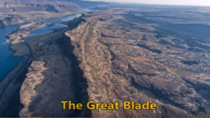
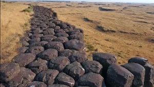
“…there were a few double falls each member of which receded at approximately the same rate, so that the island in mid-channel became very much elongated, like a great blade, as the falls receded and the canyons lengthened.” J Harlen Bretz (1928) A tall, narrow basalt ridge, coined “The Great Blade” by J Harlen Bretz, parallels Lower Grand Coulee east of Lake Lenore. The blade is the product of Ice Age floods that repeatedly rampaged Grand Coulee as recently as 15,000 years ago. Most of the floods appear to have come from sudden outbursts from glacial Lake Missoula. During flooding the coulees on either side of the Great Blade were filled with up to 800 ft turbid water. The largest floods also overtopped the Great Blade, submerging the site under at least another 100 ft of floodwater. On the west side of the blade, where Lake Lenore is located, lies the Lower Grand Coulee, which ultimately migrated 10 miles northward – all the way to Dry Falls. On the east side of the blade is the higher East Lenore Coulee, which migrated a shorter distance (~3 mi) to Dry Coulee. Like a gigantic rib the Great Blade is tallest and narrowest at its south end, widening to the north. The blade extends for almost four miles from where the head of East Lenore Coulee intersects Dry Coulee. In places the blade narrows to as little as 800 ft wide. Video produced by Bruce Bjornstad for Ice Age Floodscapes
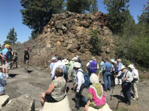
In August, Scott David, a postdoctoral researcher and Karin Lehnigk, a 2nd year PhD candidate from the University of Massachusetts visited the scablands for a week to do field studies. Karin was in search of granite erratics. Samples of these were taken to be processed for Beryllium-10 exposure dating, a robust geochemical technique which enables researchers to determine how long the object sampled has been sitting on the surface of the Earth. This information combined with computer simulations of a range of flood sizes is to test the hypothesis that the earliest floods through the Cheney-Palouse Scabland Tract were also the largest. Scott was in search of potholes. Measuring the geometry of potholes and the rocks that comprise them in a variety of locations, he is using these measurements in numerical and physical modeling experiments to explore what erosion mechanisms could generate these massive features. Were they produced by retreating waterfalls, rocks circulating at the base of the flow, large scale turbulence, or some combination of these mechanisms? The results of the study should provide insight into how the remarkable canyons that comprise the Channeled Scablands formed. On a Friday afternoon, I met up with them in Ritzville and proceeded to some granite erratics near Cow Creek southeast of town to take samples. They spent the night at our house in Washtucna and were thrilled to have hot showers, a home-cooked meal and soft beds. The days before they slept in tents on a gravel parking lot. The next morning, Chad Pritchard from EWU joined us as we took measurements from four pot-holes along the south side of Washtucna Coulee between Washtucna and Hooper. They also took granite samples from the Midcanyon Bar near Lyons Ferry before returning to the Grand Coulee area. The results of their studies were not available at time of printing. Article by Lloyd Stoess in The Scablander
National Geographic has published an outstanding article, “Formed by Megafloods, This Place Fooled Scientists for Decades”, about J Harlan Bretz and his outrageous, fantastical theories of a landscape shaped by huge floods. Most Ice Age Floods aficionados are generally aware of the story, but this one is so detailed and well written it’s worth reading for the story-telling value alone. Please see: This National Geographic site:

Bruce Bjornstad is at it again with his awesome Ice Age Floodscapes drone videos, this one from Frenchman Coulee. Watch it below and visit his Ice Age Floodscapes YouTube channel.for many more.
This is an amazing compilation of extra ordinary photographs that have been expertly labeled to assist the viewer’s understanding of the evidence supporting the creation of the Channelled Scablands in Eastern Washington State, USA. The photographs are panned and zoomed in and out on providing an overview and close-ups of flood evidence. Music playing in the background helps the viewer focus on the information displayed in an unhurried manner. The viewer can stop the screen at any time to give them more time to study the information displayed in great clarity. For teaching, this methodology is suburb! Much better than a regular film or static photos. YouTube slideshow prepared by Bruce Bjornstad, published Dec 8, 2012
Lake Missoula filled many times and emptied catastrophically in many Missoula Floods. Rhythmite sequences [a series of repeated beds of similar origin] at numerous localities provide this evidence: slack-water rhythmites in backflooded tributary valleys below the dam indicate multiple floods, and varved rhythmites in Lake Missoula attest to multiple fillings of the lake. Below the dam, most slack-water rhythmites are graded beds deposited by flood bores surging up tributary streams. They grade upward from coarse sand and gravel to silt, with occasional ice-rafted erratics. The tops of some rhythmites are marked by thin paleosols, or buried soil horizons, which indicate a period of subaerial exposure. Thus, each rhythmite represents a separate flood event, and each deposit records multiple floods. The most complete record occurs at Sanpoil Valley, an embayment on the north side of Lake Columbia, where varved rhythmites document 89 flood events, with the period of time between floods initially increasing to a maximum of about 50 years and then decreasing to less than 10 years. Thousands of varves were deposited in Lake Missoula. At the best-known Ninemile locality near Missoula, about 40 rhythmites consist of varves overlain by a sand/silt layer. The varves were deposited on the floor of Lake Missoula, and the sand/silt layers represent subaerial exposure and deposition in a stream. The number of varves in each rhythmite varies from 9 to 40, decreasing regularly upward, and the total number of varves is just less than one thousand. An interpretation of these data would suggest: [1] Lake Missoula filled and emptied [in a catastrophic flood] about 40 times, [2] it took 9 to 40 years to fill the lake, each successive lake requiring less time, and [3] the process was repeated over a period of about one thousand years. Because Ninemile is about in the middle of the very long lake, the record here would not provide a complete history of the lake. Correlating Ninemile with the downstream record would suggest these events were in the latter half of the entire flood history.
New research reveals the ancient animals survived some 8,000 years later than previously thought Frozen soil samples collected around a decade ago are rewriting our understanding of iconic Ice Age animals like the woolly mammoth. The soil samples were pulled from Canada’s permafrost in the early 2010s, but no work on them had been published until recently. A new analysis of the DNA samples reveals that woolly mammoths, wild horses and steppe bison were around as recently as 5,000 years ago—some 8,000 years later than previously thought, according to a study published this week in Nature Communications. Scientists reconstructed the ancient ecosystem using radiocarbon dating of plant material trapped in the soil in combination with microscopic genomic sequences from animal species. Their results showed something unexpected: Large mammals like mammoths and horses were already on the decline before the climate warmed. The scientists found evidence of woolly mammoth and North American horse DNA as recently as 5,000 years ago, which means the animals held out until the mid-Holocene. Excerpted from the Smithsonian Magazine article by Corryn Wetzel

This video by Tom Foster and Nick Zentner about the Columbia River Gorge features an incredible variety of geology and human history as it slices through the Cascade Range of the Pacific Northwest. The Columbia River Basalts, the Missoula Floods, the Bonneville Flood, the Bridge of the Gods, Celilo Falls, Multnomah Falls, Beacon Rock, Lewis and Clark, the Oregon Trail, the Columbia River Highway, and more!

Big feet. Little feet. A heel here. A toe there. A digitally enhanced photo of a footprint found at Calvert Island, British Columbia that researchers dated to 13,000 years old. Credit Duncan McLaren Stamped across the shoreline of Calvert Island, British Columbia, are 13,000-year-old human footprints that archaeologists believe to be the earliest found so far in North America. The finding, which was published Wednesday in the journal PLOS One, adds support to the idea that some ancient humans from Asia ventured into North America by hugging the Pacific coastline, rather than by traveling through the interior. “This provides evidence that people were inhabiting the region at the end of the last ice age,” said Duncan McLaren, an anthropologist at the Hakai Institute and University of Victoria in British Columbia and lead author of the study. “It is possible that the coast was one of the means by which people entered the Americas at that time.” Dr. McLaren and his colleagues stumbled upon the footprints while digging for sediments beneath Calvert Island’s beach sands. Today, the area is covered with thick bogs and dense forests that the team, which included representatives from the Heiltsuk First Nation and Wuikinuxv First Nation, could only access by boat. At the close of the last ice age, from 11,000 to 14,000 years ago, the sea level was six to ten feet lower. The footprints were most likely left in an area that was just above the high tide line. “As this island would only have been accessible by watercraft 13,000 years ago,” Dr. McLaren said, “it implies that the people who left the footprints were seafarers who used boats to get around, gather and hunt for food and live and explore the islands.” They found their first footprint in 2014. While digging about two feet beneath the surface in a 20-square-inch hole, they saw an impression of something foot-shaped in the light brown clay. In 2015 and 2016, they returned and expanded the muddy pit. They discovered several more steps preserved in the sediment. The prints were of different sizes and pointed in different directions. Most were right feet. When the team was finished they had counted 29 in total, possibly belonging to two adults and a child. Each was barefoot. The researchers think that after the people left their footprints on the clay, their impressions were filled in by sand, thick gravel and then another layer of clay, which may have preserved them. Using radiocarbon dating on sediment from the base of some footprint impressions, as well as two pieces of preserved wood found in the first footprint, Dr. McLaren and his team found them to be 13,000 years old. That would make them the oldest preserved human footprints in North America. “It’s not only the footprints themselves that are spectacular and so rare in archaeological context, but also the age of the site,” said Michael Petraglia, an archaeologist from the Max Planck Institute for the Science of Human History in Germany who edited the paper for PLOS One but was not involved in the work. “It suggests an early entrance into the Americas.” Dr. Petraglia said the footprints also provided strong evidence for the coastal movement hypothesis and he added that they may have traveled the so-called “Kelp Highway,” a hypothesis that underwater kelp forests supported ecosystems down the North Pacific coast that helped ancient seafaring people hunt, develop and migrate. “The work is important because it shows the ‘real’ people, not just artifacts or skeletal remains,” said Steve Webb, a biological archaeologist at Bond University in Australia. “However, the footprints are limited in number and don’t shed light on activities or movement that tell us very much.” He added that future hunts for footprints should keep in mind that not everyone from this time period walked around barefoot. If anthropologists are too busy searching for soles, toes and arches, they might miss clues from those who wore animal skin shoes. Reprinted from New York Times – Earliest Known Human Footprints in North America Found on Canadian Island By NICHOLAS ST. FLEUR, March 28, 2018
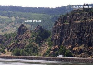
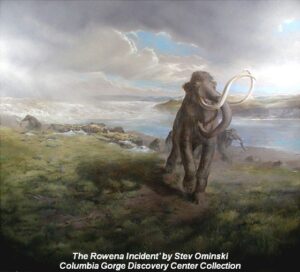
Scenic Rowena Crest and the Tom McCall Preserve area provide an incredibly scenic place to let your feet, and your imagination wander as you look out on a major chokepoint along the Ice Age Floods path. The wildflower displays are amazing during the Spring, but several compelling flood-related features are visible from the vantage of the Rowena Crest Viewpoint any time of year. Rowena Crest lies nearly 700 feet above the Columbia River at the upstream end of the Rowena Plateau, a miles-long plateau that the river flows along. Just upriver from the plateau is the narrow section of the Gorge known as the Rowena Gap The drive to the viewpoint on old Hwy 30 from either east or west is a spectacular ride through a wonderous section of the Columbia River Gorge. A roundabout parking area at the viewpoint, with a safety wall above a sheer cliff, provides a great observation point eastward toward Rowena Gap. At Rowena Crest it’s easy to imagine what it might have been like to witness the approach of those massive floods. There is not yet scientific evidence that humans were in the area to bear witness to the Ice Age Floods, but there is solid evidence of humans in the Americas by that time. And there is growing concensus that if they came in during a glacial maximum, they would have come in by a coastal route that offered plentiful food and shelter for their journey. The mouth of the Columbia River would have been the first major waterway path inland that might have led them to settle in the area of the Floods. Your village might have been situated across the Columbia at the mouth of the Klickitat River where the town of Lyle now sits. If you were foraging, or just relaxing, atop Rowena Crest on a late summer day, you might have felt the ground begin to temble as if there were a small earthquake, but the trembling would have slowly increased for a few hours. Eventually you would have heard a low roaring sound that also grew over an hour or more before you could see turbulent brown muddy water begin flooding across the broad basin to the east. Then the roaring flood of water, only a few feet deep at first, would have entered the narrows, now called Rowena Gap, and sped on, crashing against the promontory you’re standing on and being diverted toward your village which was quickly washed away by the muddy torrent. But the muddy flood waters would have kept rising, unlike the Spring floods you’re used to on the Columbia, becoming a hundred feet deep, then two hundred as the levels just kept rising. Soon a huge whirlpool formed in the flood waters near the base of the promontory and a giant eddy formed where your village had been as flood waters flowed backward up the Klickitat River even as the bulk of the water continued downstream on the main stem of the Columbia. As the flood waters reached 400 and 500 feet deep and kept coming, suddenly to your right and left, huge blocks of the promontory broke off and slumped down into the rampaging flood waters. Now, even more fearful, you would have begun running south toward higher ground, climbing higher and higher as the still rising flood waters poured across the plateau and plunged into the small creek valley to the west, tearing away at the valley walls and massively widening that little valley. Eventually the flood waters stopped chasing you upward as you climbed higher, 200 then 300 feet above the now submerged promontory. Now, as you turned and looked out across that expanse of muddy water you could see massive white blocks of ice being carried along on the flood waters, similar but inconceivably larger than the ice blocks carried on the river during the Spring floods. But the flood waters didn’t begin to recede that day, nor the next, as they might in the Spring floods. In fact it was almost half a lunar cycle before they began to slowly recede, exposing a mud coated Columbia River valley that was now noticeably wider, with layers of shear vertical rock walls extending over 1000 feet above the normal river level below. As you began the recovery from the floods devastation, your family returned from from their hunting and gathering in the high mountain meadows, and you have an incredible story to pass along to them and your ancestors. This story is easy to imagine as you look out to the east from Rowena Crest. The onrushing Ice Age Floods waters easily flowed over the low relief of the broad Dalles Basin to the east, but the major Rowena Gap created a chokepoint in the path of the floods as they made their way through the Columbia River Gorge. This “hydraulic dam” forced the flood waters to build to over 1000 feet deep in this area, flowing hundreds of feet deep over Rowena Crest while forming a temporary lake in The Dalles basin. It is estimated that many of the 40-100 Ice Age Floods may have taken up to a month to completely flush through the system to the Pacific Ocean, but the duration of the flood waters at any point along the path probably lasted less than a couple of weeks. But this was more than enough to create several major floods features visible from this vantage point. At Columbia River level below and east of the promontory is a round Kolk pond that was created by giant whirlpools in the flood waters as they were deflected around the Rowena Crest promontory. Other similar Kolk features can also be seen on the Dallesport area to the east, and along the hiking path atop Rowena Crest where they are marked by surrounding groves of oak trees. Across the Columbia, the floods deposited a huge eddy gravel bar that the entire town of Lyle, Washington is built upon. The Klickitat River was backed
Washington State Geological Survey is collecting, analyzing, and publicly distributing detailed information about our state’s geology using the best available technology – LIDAR – an acronym for Light Detection And Ranging. The main focus of this new push for LIDAR collection is to map landslides, but there are innumerable additional benefits and applications of this data both inside and outside of the field of geology. A number of amazingly beautiful and revealing images are featured on the WA-DNR Flickr website, along with a trove of information about the technology and it’s applications. LIDAR is a surveying method that measures very precise distance to a target by illuminating that target with a pulsed laser light and measuring the reflected pulses with a sensor. Differences in laser return times and wavelengths can then be used to make digital representations of the target. LIDAR is expensive, but it can easily remove vegetation/grass/trees as it uses an emitting source and interferometry criteria to find the “last echo return” that is assumed as the ground, even in very dense scenarios (forests, corn fields, etc). LIDAR uses ultraviolet, visible, or near infrared light to image objects. It can target a wide range of materials, including non-metallic objects, rocks, rain, chemical compounds, aerosols, clouds and even single molecules. LIDAR is widely used for many different applications. Some (but by no means all) of those uses include: Geology and Hazards, Forestry, Graphics, Navigation, Meteorology and Fir,e Land-use planning, Archaeology and Agriculture. In geology, bare earth models allow closer study of geomorphology, which is the study of the origin of the topography of the earth. Floods, faults, landslides, erosion, and glaciers leave their mark on the landscape, and while these marks can be hidden by dense vegetation, they can’t hide from LIDAR. LIDAR can be used in the field of archaeology to find things hidden by the forest canopy. Large features that would be indistinguishable on the ground are readily apparent in a LIDAR survey, leading archaeologists to sites they might not have otherwise found. For example, intensity returns can be used to detect features just below the surface that affect plant growth.
Monument Valley, the Grand Canyon, Niagara Falls: these ancient wonders show how nature’s forces have shaped the face of our planet on a vast timescale, how great landmarks are the work of millions of years of slow, imperceptible erosion by wind and water. But here, across 16,000 square miles of Washington State, abrupt rips and scars in the landscape defy this explanation. What could have formed these tall canyons and immense dry waterfalls? What could have gouged out these gigantic potholes? Whatever happened, the forces unleashed here created one of the Earth’s most enigmatic landscapes. For more than a century, scientists have been grappling with this geological mystery, descending through thousands of years of Earth’s history in a struggle to uncover, layer by layer, how this landscape was formed. Now the clues point to a sequence of events culminating in a massive natural catastrophe. Explore the features and reasoning that lead to the recognition of the “Missoula (Outburst) Floods” and helped to solve “The Mystery of the Megaflood (Spokane Floods or the Bretz Floods)”

There’s a Columbian Mammoth hiding out in Coyote Canyon down Kennewick way, and MCBONES Research Center Foundation is working to uncover his/her hiding place. For a small contribution you can tour this hide-and-seek site, or you can volunteer to help uncover the hidden mammoth. Sound interesting? Find out more in this short video produced by Mark Harper of “Smart Shoot“, or visit the MCBONES website. The Mid-Columbia Basin Old Natural Education Sciences (MCBONES) Research Center Foundation provides local K-12 teachers and their students, as well as other volunteers, an opportunity to actively participate in laboratory and field-based research in paleontology, geology, paleoecology, and other natural sciences primarily within the Mid-Columbia Region of southeast Washington State.
I’ve found there is huge public interest and concern about the catastrophic effects of the Eagle Creek Fire on the Columbia River Gorge. Pictures of ridgeline after ridgeline enveloped in bright orange fire, trees bursting into towering flames, and the choking smoke that filled valleys throughout the Pacific Northwest are truly a hellish image of Armageddon visited on the entire area. But, while the temporary loss of recreational trails and green forest aesthetics, and the increased potential for landslides and falling snags are inconvenient and even somewhat dangerous, the truth is that the recent fires have not ruined the natural areas of the West and the Gorge in particular, but instead have refreshed and renewed them. This past summer I’ve been interpreting geology for a new Columbia Gorge Master Naturalist Program, working beside forest ecology experts who are extremely optimistic regarding the effects of the Eagle Creek Fire. One of those experts, wildlife habitat expert Bill Weiler, writes, “Life will return to burned areas in short order. Fungi are already crawling around in the ashes of the fire, laying the foundation for soil that will support the plants that will constitute the early stage of the forest’s re-growth—a time when heat from the fire and sunlight newly reaching the ground in the absence of a canopy encourages a new crop of plants to firm up the soil structure that will allow gigantic trees to thrive. And ash is nature’s fertilizer. Plant blight, disease and insects are reduced or eliminated by burns. Mineral soil is the compost that Douglas fir seedling roots need to grow. “Dead trees” or snags are full of life.” In a typical forest fire a third of the trees will be scorched and dead, a third will be moderately to severely damaged, and a third will be essentially unscathed. Reports from the Eagle Creek Fire describe that fire as a discontinuous “mosaic burn” with much less devastation even than the typical forest fire burn. There is a broad consensus among scientists that we have considerably less fire of all intensities in our Western U.S. forests compared with natural, historical levels, when lightning-caused fires burned without humans trying to put them out. Early in the 20th century, before fire suppression became the norm, the average annual burn area in the western states was over 25 million acres, compared to a recent average of 4-6 million acres. According to Oregon State University Professor John Bailey, a century’s worth of suppressing wildfire in the United States has created conditions, especially in the West, that will ensure longer fire seasons because of longer, drier and hotter summers. Those conditions point to the need for “actively managed” forests which could include more deliberately set and managed prescribed fires. “Easily two-thirds or more of the Gorge fire is really good ecological fire,” Professor Bailey said, “the fire does some of the fuel management for us.” There is an equally strong consensus among scientists that fire is essential to maintain ecologically healthy forests and native biodiversity. This includes large fires and patches of intense fire, which create an abundance of biologically essential standing snags and naturally stimulate regeneration of vigorous new stands of forest. These areas of “snag forest habitat” are ecological treasures, not catastrophes, and many native wildlife species depend on this habitat to survive. More than 260 scientists wrote to Congress in 2015 noting that snag forests are “quite simply some of the best wildlife habitat in forests. ” Much of the Eagle Creek Fire burn area is closed to civilian activities due to the danger from flare-ups, rock slides and falling snags. The fire is less than 50% contained due to the ruggedness and inaccessibility of much of the area. Though it is still burning it is not expected to flare-up again until Winter rains and snow completely douse the embers.
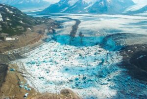
A recent Smithsonian Magazine article gives some interesting insights to present-day Jökulhlaups (glacial outburst floods) that are but minuscule relatives of the cataclysmic Ice Age Floods. Iceberg Lake was on the edge of a western tributary of the Tana Glacier, but in 1999 the lake suddenly vanished. Dammed on its southern end by ice, the water, with persistently warming temperatures, had bored a hole under the ice and escaped through tunnels to emerge ten miles away and empty into the Tana River. The sudden drainage of a glacier-dammed lake is not uncommon. “Some lakes in Wrangell-St. Elias regularly drain,” Loso said. Hidden Creek Lake, for instance, near McCarthy, drains every summer, pouring millions of gallons through channels in the Kennicott Glacier. The water gushes out the terminus of the Kennicott, causing the Kennicott River to flood, an event called a jokulhlaup—an Icelandic word for a glacial-lake outburst flood. “The Hidden Creek jokulhlaup is so reliable,” said Loso, “it has become one of the biggest parties in McCarthy.” But the disappearance of Iceberg Lake was different, and unexpected. It left an immense trench in the ground, the ghost of a lake, and it never filled up again. The roughly six-square-mile mudhole turned out to be a glaciological gold mine. The mud, in scientific terms, was laminated lacustrine sediment. Each layer represented one year of accumulation: coarse sands and silts, caused by high runoff during the summer months, sandwiched over fine-grained clay that settled during the long winter months when the lake was covered in ice. The mud laminations, called varves, look like tree rings. Using radiocarbon dating, Loso and his colleagues determined that Iceberg Lake existed continuously for over 1,500 years, from at least A.D. 442 to 1998. “In the fifth century the planet was colder than it is today,” Loso said, “hence the summer melt was minimal and the varves were correspondingly thin.” The varves were thicker during warmer periods, for instance from A.D. 1000 to 1250, which is called the Medieval Warming Period by climatologists. Between 1500 and 1850, during the little ice age, the varves were again thinner—less heat means less runoff and thus less lacustrine deposition. “The varves at Iceberg Lake tell us a very important story,” Loso said. “They’re an archival record that proves there was no catastrophic lake drainage, no jokulhlaup, even during the Medieval Warming Period.” In a scientific paper about the disappearance of Iceberg Lake, Loso was even more emphatic: “Twentieth-century warming is more intense, and accompanied by more extensive glacier retreat, than the Medieval Warming Period or any other time in the last 1,500 years.” Loso scratched his grizzled face. “When Iceberg Lake vanished, it was a big shock. It was a threshold event, not incremental, but sudden. That’s nature at a tipping point.” One of the most startling, and devastating, consequences of this rapid melting of the ice was the Icy Bay landslide. The Tyndall Glacier, on the southern coast of Alaska, has been retreating so quickly that it is leaving behind steep, unsupported walls of rock and dirt. On October 17, 2015, the largest landslide in North America in 38 years crashed down in the Taan Fjord. The landslide was so enormous it was detected by seismologists at Columbia University in New York. Over 200 million tons of rock slid into the Taan Fjord in about 60 seconds. This, in turn, created a tsunami that was initially 630 feet high and roared down the fjord, obliterating virtually everything in its path even as it diminished to some 50 feet after ten miles. “Alder trees 500 feet up the hillsides were ripped away,” Anderson says. “Glacial ice is buttressing the mountainsides in Alaska, and when this ice retreats, there is a good chance for catastrophic landslides.” In other ranges, such as the Alps and the Himalaya, he says, the melting of “ground ice,” which sort of glues rock masses to mountainsides, can release enormous landslides into populated valleys, with devastating consequences. “For most humans, climate change is an abstraction,” Loso says when I meet him in his office, which is down a long, dark, heavily beamed mine building in Kennecott. “It’s moving so slowly as to be basically imperceptible. But not here! Here glaciers tell the story. They’re like the world’s giant, centuries-old thermometers.” Read the entire article “A Daring Journey Into the Big Unknown of America’s Largest National Park” online at SmithsonianMag.com

Bluefish Caves directly challenged mainstream scientific thinking. Evidence had long suggested that humans first reached the Americas around 13,000 years ago, when Asian hunters crossed a now submerged landmass known as Beringia, which joined Siberia to Alaska and Yukon during the last ice age. From there, the migrants seemed to have hurried southward along the edges of melting ice sheets to warmer lands in what is now the United States, where they and their descendants thrived. Researchers called these southern hunters the Clovis people, after a distinctive type of spear point they carried. And the story of their arrival in the New World became known as the Clovis first model. Jacques Cinq-Mars, however, didn’t buy that story—not a bit.
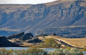
THE GRAND COULEE – A Floods Poem THE GRAND COULEE Older than legends,Younger than mountains,The earth remembersThe Great Inland Sea. And that Sea emptiedIn torrential furyNever imaginedEven in dreams. Down through the canyons,Flood of all riversCarving the couleesTime, time again. Roiled surging waters,Thunder of thunders,Swift toward the oceanReshaping the plain. Gone with the glaciersIs the great Lake Missoula,Gone from remembrance,Like mist in the wind. Yet the story is etchedIn the canyons and couleesLeft for those who imagineTo seek and to find. David Wahl January 4, 2002 Lower Grand Coulee Upper Grand Coulee at Steamboat Rock (left)

With all deference to the book and movie “The Martian”, wouldn’t you, as part of an interplanetary expedition, prefer to be protected from the radiation, micro-meteorites and extreme temperature fluctuations of the Moon or Martian surface? Though some of the hazards depicted in “The Martian” are way over-dramatized (the thin Martian atmosphere wouldn’t sustain the depicted raging storms), there are still hazards aplenty on the surface. So why not site your habitat in a cozy lava tube, protected from many of those surface nasties. At least that’s some of the reasoning behind a European Space Agency (ESA) effort to map a portion of Spanish lava tube in centimeter-scale detail as part of the ESA’s 2017 Pangaea-X campaign. Some chambers in the 8 km long La Cueva de los Verdes lava tube are large enough to hold residential streets and houses (or a prototype Martian research station/habitat). In less than 3 hours the cave research team mapped the lava tube using the smallest and lightest imaging scanner on the market and a wearable backpack mapper that collects geometric data without a satellite and synchronizes images collected by five cameras and two 3D imaging laser profilers. While the data is still being analyzed, ESA has released this ghostly fly-thru of a 1.3 km portion of the lava tube. Click the play button and prepare to take a pseudo-trip to Mars. So, the next time you visit a cave or lava tube, especially a large one, imagine yourself in a spacesuit on the Moon or Mars and realize that you’re actually an inner-space explorer. But don’t be too surprised at the creatures you may run into, they’re just other inner-space explorers too.
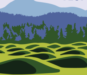
Check out this video about the Washington 100, a cool new geotourism website by the Washington Geological Survey featuring 100 places to experience amazing geology in Washington State. Then explore the website itself at wa100.dnr.wa.gov

Geologists have been investigating a potential cycle in geological events for a long time. A recent analysis on the ages of 89 well-understood geological events from the past 260 million years show a catastrophic 27.5 million year pulse in eight clusters of world-changing geologic events over geologically small timespans. This pulse of clustered geological events – including volcanic activity, mass extinctions, plate reorganizations, and sea level rises – is incredibly slow, a 27.5-million-year cycle of catastrophic ebbs and flows. As you can see from the graph, some of those times were tough – with over eight of such world-changing events clustering together over geologically small timespans, forming the catastrophic ‘pulse’. “These events include times of marine and non-marine extinctions, major ocean-anoxic events, continental flood-basalt eruptions, sea-level fluctuations, global pulses of intraplate magmatism, and times of changes in seafloor-spreading rates and plate reorganizations,” the team writes in their paper. These cyclic pulses of tectonics and climate change may be the result of geophysical processes related to the dynamics of plate tectonics and mantle plumes, or might alternatively be paced by astronomical cycles associated with the Earth’s motions in the Solar System and the Galaxy. Luckily for us, the research suggests we have another 20 million years before the next ‘pulse’.
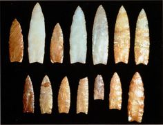
Richard Waitt kindly shared his recent paper published June 2016 in Quaternary Research, titled “Megafloods and Clovis cache at Wenatchee, WA.” “It covers the reach mainly from Chelan Falls to below West Bar, tries to tell the story of sequential megafloods coming to Wenatchee area by different routes at different times, and tries to work in the story of early Homo sapiens in the region, especially as contemplated from the 1988-1990 excavations of the East Wenatchee Clovis cache,” said Waitt in an email to the Wenatchee Valley Erratics. His easy-to-read and immensely interesting paper covers both the geological and the archaeological stories for the Wenatchee area. Did humans witness megafloods? Read the paper Megafloods and Clovis cache at Wenatchee, Washington to find out!

Check out this 2-Minute Geology expedition with Nick Zentner and Tom Foster exploring the Giant Current Ripples at West Bar and Camas Prairie. Ice age floodwater 650 feet deep – moving at 65 miles per hour – left Giant Current Ripples along the Columbia River at West Bar! The ripples at West Bar are 20 feet high, spaced up to 100 yards apart. Giant Current Ripples at Camas Prairie, Montana are also described. The Montana ripples helped Joseph Pardee understand that Glacial Lake Missoula had emptied suddenly. Learn more about Glacial Lake Missoula, Lake Bonneville and the Ice Age Floods at http://hugefloods.com/

Hiking Drumheller Channels Ice Age Floods National Geologic Trail There are scads of hiking trails all through Drumheller Channels National Natural Landmark. On a cloudy day in early June we took off on a couple of exploratory hikes that were simply amazing. We first proceeded south from the parking lot at Lower Goose Lake, running through late Spring wildflowers, eventually looking for one of Bruce Bjornstad’s geocaches. We wandered over hills and down into deeper valleys, always surrounded by the towering walls of basalt defining that section of Drumheller Channels. Along the way we found an area of apparent Kolk depressions with odd spires of basalt poking up out of the middle of a central mound. Soon we passed through a reedy area that bounded the southern edge of Lower Goose Lake. We continued on south to the edge of Black Lake where the geocache was supposed to be, but after 20 minutes with 4 of us looking in the area of the GPS coordinates, we finally decided the cache was no longer there and headed back. The hike was easy, very pleasant, and mercifully cool due to the cloudy morning. We then drove north across the O’Sullivan Dam, and back south through Columbia National Wildlife Refuge to the W. McManamon Road entrance to Crab Creek Marsh Unit #3 and the Basalt Columns at Drumheller Trailhead, the kickoff point to go to the top of “Nick’s Columns”. Nick Zentner’s videos about the columns are great, but the blooper where his rock hammer falls down between columns is priceless. We just had to see those columns for ourselves, and we weren’t disappointed. It’s interesting how only the columns along the edge are free standing, while those inboard are packed around with sediment. The little rain the area gets probably washed the sediment out of the spaces between the bordering columns. After walking around for a while we made our way back to the car and drove to the Drumheller Channels National Natural Landmark overlook for a final sweeping viewpoint. The entire area is huge and worth several days of exploring, but it’s also pretty easy to have a great time in just a few hours. This is a place you just have to experience. Quick Facts Location: Adams County, Washington 99371
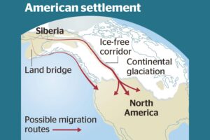
Analysis of how long erratics have been exposed on ice-free ground in the hypothesized “Late Pleistocene ice-free corridor migration route” suggests that route was not fully open until about 13,800 years ago, and the ice sheets “may have been 1,500 to 3,000 feet (455 to 910 m) high in the area where they covered the ice-free corridor,” according to study lead author Jorie Clark, a geologist and archaeologist at Oregon State University. Clark said, “we now have robust evidence that the ice-free corridor was not open and available for the [Late Pleistocene] first peopling of the Americas.” If evidence of humans in the Americas prior to the 30,000 years ago is ultimately found, that evidence does not preclude the possibility of ice-free corridor migration before closure of the corridor.
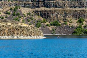
Dry Falls Kayaking Ice Age Floods National Geologic Trail Most Pacific Northwesterners know how awesomely majestic and stunningly beautiful Dry Falls is, if only from the pictures that seem to show up everywhere. If you haven’t been there in person yet you definitely need to make that trek into central Washington. The drive through the lower Grand Coulee, as awesome as it is, is only the teaser for the view from the Dry Falls Visitor Center. But if you really want to get into the majesty, consider taking a kayak down to Dry Falls Lake or Deep Lake, at the base of those monstrous cataracts. The dirt road to Dry Falls Lake isn’t for the faint of heart, and a good, high clearance SUV is recommended. But paddling the lake near the base of those 400 foot high cliffs is worth the effort. Bordered by reeds and accompanied by waterfowl, an hour-long paddle around the lake is leisurely, relaxing, and totally absorbing. And who knows, you might end up in someone else’s fantastic photo of Dry Falls from the Visitor Center. The road to Deep Lake is paved, so it is a much easier place to get to. And the ramp at the lake makes getting in and out pretty easy… just be careful of the slippery algae on the ramp. Once you’re on the lake an hour’s paddle will take you from an area bordered by rolling hills to a section bounded by high vertical walls. Don’t fall out in this area because there’s nowhere to climb out or beach your boat to climb back in. Still, it’s astoundingly interesting to get up close and see the variety of textures in the basalt walls. Of course, you can also do some great hiking in both areas, though climbing the blade takes quite a bit of effort and confidence, but the view is pretty spectacular. Unfortunately, the way back down isn’t any easier than the way up. Choose your route carefully. Quick Facts Location: Grant County, Washington, United States 99371 MANAGED BY:Washington State ParksWebsite: https://iafi.org/go-do/washington/ Dry Falls is a 3.5-mile-long scalloped precipice with four major alcoves, in central Washington scablands. A Discover Pass is required for vehicle access to state parks for day use. For more information about the Discover Pass and exemptions, please visit the Discover Pass web page.
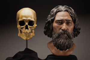
Kennewick Man is the name generally given to the skeletal remains of a prehistoric Paleoamerican man found on a bank of the Columbia River near Kennewick, Washington, on July 28, 1996. Two young men discovered the skull of Kennewick Man when they stepped on something that looks like a large rock. They had stumbled upon a human skull while wading in the shallows along the Columbia River. They gave the skull to police, They called the police. The police brought in the Benton County coroner, Floyd Johnson, who was puzzled by the skull, and he in turn contacted James Chatters, a local archaeologist. Chatters and the coroner returned to the site and, in the dying light of evening a skeleton was found scattered nearby, complete with a stone spear point driven into the hip. They plucked almost an entire skeleton from the mud and sand. It is one of the most complete ancient skeletons ever found and anthropologists determined it was at least 9,200 years old. It was the oldest nearly complete skeleton found in North America, but the discovery was more than a thrilling moment for archaeologists. The find kicked off a long-running scientific and cultural controversy.— and it sparked a legal battle that lasted more than two decades. Get more of the story at https://www.smithsonianmag.com/history/kennewick-man-finally-freed-share-his-secrets-180952462/
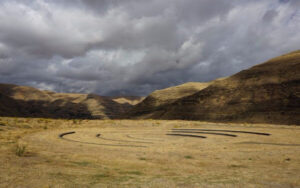
On October 7th at Chief Timothy Park near Clarkston, WA at the latest Confluence Story Gathering, Thomas Morning Owl (Umatilla tribe) noted there are indigenous people’s stories of massive floods going back to 14,000 years ago. While he didn’t elaborate, it would be very interesting to have these stories shared as first-hand accounts of the Ice Age and/or Bonneville Floods. Confluence Story Gatherings are designed to elevate native voices in our understanding of the Columbia River system. This Confluence Story Gathering explored stories and perspectives from Nez Perce homelands, where a panel of indigenous thinkers and storytellers — Allen Pinkham, Sr. (Nez Perce), Thomas Morning Owl (Umatilla) and Jefferson Greene (Warm Springs) — shared their observations. Despite the strong winds, rain and even hail, the stories prevailed. Confluence Project is a community supported nonprofit that connects people to place through art and education. We work in collaboration with Northwest communities, tribes and celebrated artist Maya Lin to create reflective moments that can shape the future of the Columbia River system. We share stories of this river through six public art installations, educational programs, community engagement and a rich digital experience. The six projects span 438 miles from the mouth of the Columbia River to the gateway to Hell’s Canyon, with sites in both Oregon and Washington. These are “teachable places,” transformed and reimagined to explore the confluence of history, culture and ecology in our region. Each work references a passage from the Lewis and Clark journals as a snapshot in time, while comparing it with the deeper story.
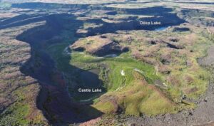
Castle Lake fills a plunge-pool at the base of a 300-ft tall cataract at the opposite (east) end of the Great Cataract Group from Dry Falls, above the east end of Deep Lake. A set of steel ladders put in place during the construction of the Columbia Basin Irrigation Project allow for a safe descent into the basin. In the basin are great views of giant potholes, the flood-sheared face of Castle Rock, as well idyllic Deep Lake. The Castle Lake Basin lies along the east end of the Great Cataract Group. At the base of the cataract is lovely blue-green Castle Lake plunge pool nestled into the rock bench below. Castle Lake lies within a single recessional cataract canyon eroded down to a flood-swept, pothole-studded rock bench that stands 100 feet above Deep Lake. This is the same rock bench of Grande Ronde Basalt where dozens of potholes occur at the opposite (western) end of Deep Lake. Castle Rock itself is an isolated butte along the west side of the Castle Lake basin. It is a faceted butte escarpment nearly sheared off by monstrous flood forces moving across the cataract.

The Columbia River Gorge is an incredibly popular area to visit, and that’s for good reason, the setting is uniquely spectacular. The Gorge encompasses: Easily accessible ecozones that range through boreal conifer forests, oak woodlands, high desert grasslands and alpine environments in only 40 miles, Dazzling viewpoints and scenery, including beautiful waterfalls that cascade over the high basalt ramparts that bound the relatively narrow Gorge and the majestic Columbia River running through it, Mt. Adams, Mt. St. Helens and Mt. Hood, imposing snow-covered stratovolcanoes lying less than 40 miles north and south of the Gorge, Picturesque small towns that are bounded by extensive federally- and state-protected natural areas throughout the length of the Gorge, Abundant recreation opportunities including hiking, road/mountain biking, windsurfing and kiteboarding, whitewater kayaking and rafting, fishing, hunting, alpine/cross-country skiing and snowshoeing, Numerous award-winning wineries and breweries, restaurants and pubs, shops, galleries, museums, parks, hotels and campgrounds, And all this is lying at the back doorstep of Portland, Oregon. The Gorge is also a geologic wonderland, exposing stories about: The 40 million year history of the Columbia River, The series of massive Columbia River Basalt flows 18-12 million years ago, The rise of the Cascade Mountain Range since about 5 million years ago, The passage of numerous, up to 1000 feet deep Ice Age Floods that reshaped the Gorge 18-14 thousand years ago, Tectonic faulting and folding, landslides, earthquakes, forest fires, and The often intertwined lives and stories of the people who have lived here. Of course, with all this bounty the area is also a robust tourist mecca, which can mean limited accommodations for summer crowds. Most attractions are easy to drive to, but bus tours and river cruises are also available. Due to the popularity, some of the iconic attractions now seasonally restrict vehicle access and require permits.

This 3:50 minute animation, presented by the Crown Point Country Historical Society, illustrates the growth of the Cordilleran Ice Sheet, the damming and back-up of Glacial Lake Missoula, and the progress of an Ice Age Flood through WA and OR after an ice dam collapse.

Williams Lake Cataract is an ancient, dry waterfall left behind along the Cheney-Palouse Scabland Tract in eastern Washington after Ice Age flooding recessionally ripped out underlying basalt to produce this massive cataract. Video produced by Bruce Bjornstad, Ice Age Floodscapes
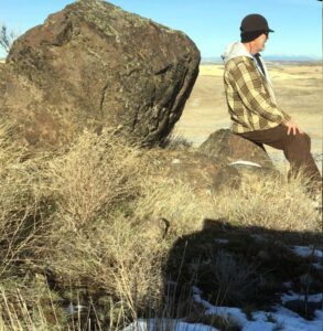
As a city kid in the ‘60s my family occasionally visited my grandparents in the farm country of Washington State’s Waterville plateau. My grandfather and two uncles were wheat farmers near the small town of Withrow, the future site of which had been partly hedged in by the Okanagan lobe of the Cordilleran Ice Sheet many thousands of years ago. Sometimes my father and I would join my uncles on the dusty 15-minute drive “out in the hills” to the sagebrush-surrounded corral, well house and large cement watering trough that served the cattle herd pastured there. Overlooking the corral was a tall hill I would sometimes climb while the trough was refilling. Warned to beware of rattlesnakes, a tiring five- or ten-minute ascent would get me to the top. Astride a large boulder, I would survey the corral far below, the sound of the pump engine distantly laboring. Around me was a panorama of other hills, about whose origins it had never occurred to me to wonder. “My hill” was steep enough that even oblong rocks I tossed down its flank would often bounce and roll clear to the bottom. On occasion, this would elicit salty, muffled hollering from Dad to cease and desist. I’m a half-century older, now, but I wish I had then understood the remarkable history of my hill. How would it have felt at that young age to know that a vast ice sheet had blanketed this terrain some 12,000 years earlier and that the hill I stood on had been its progeny? That, as that glacier began to melt, streams and rivulets had formed on its immense surface? That small sinkholes and other weaknesses in the rotting ice had allowed those waters to sculpt caverns inside the glacier? That those waters carried copious quantities of sediment and rock debris captured as the glacier eroded its way hundreds of miles southward? That my hill, like an embryo within an icy womb, had begun to grow inside one of those expanding interior caverns, ultimately to be deposited on solid ground as a kame, a lasting testament to the retreating glacier? Would I have deduced that the glacier had been at least as thick upon the land as my kame was high above the corral below me? That the erratic boulder on which I sat had been deposited on that kame like a cherry atop a geological sundae? I formed an early affection for the Withrow country because of the many relatives who, not so long ago, had peopled that farmland. It’s strange to contemplate that they are mostly gone from this land now, making it seem somewhat alien to me for their absence. And yet that hill remains, a mute sentinel having witnessed the glacier that birthed it, the quiet passage of the millennia, grandpa’s construction of that watering trough in 1948, and the naive delight of a young city kid climbing its flanks in the 1960s. Dan Jordan – IAFI Wenatchee Erratics Chapter
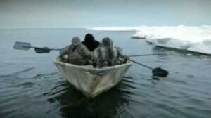
During the last ice age, which route was taken by the first humans to reach the Americas, and did they travel by foot, boat or both? Humans first arrived in North America at least 15,500 years ago. Exactly how they got there, however, constitutes one of the longest-standing debates in archaeology. For decades, scientists assumed that people first arrived in the Americas by walking south from the now-flooded land bridge in the Bering Strait that once connected Russia to Alaska when sea levels were lower during the last ice age. But recent evidence suggests that these people were not the first to set foot on the continent. According to the now-dominant “coastal route theory,” that distinction belongs to humans who boated down the Pacific coast several millennia earlier. A 2023 study(opens in new tab), for instance, found that coastal conditions were favorable during two time windows: from 24,500 to 22,000 years ago, and from 16,400 to 14,800 years ago. And while the science is far from settled, the evidence increasingly points to the first Americans arriving by sea or land along the coast. “The pendulum is swinging in support of the coastal corridor being the route taken by the first Americans,” Michael Waters(opens in new tab), director of the Center for the Study of the First Americans at Texas A&M University, told Live Science in an email. “But we still need the smoking gun: an early site along the coast.” Until 20 years ago, the best available archaeological evidence(opens in new tab) suggested that humans first arrived in North America about 13,000 years ago. The rise of the Clovis people — whose 13,400-year-old remains were discovered in Clovis, New Mexico, in the early 1900s — coincided perfectly with the formation of an ice-free corridor along the Rocky Mountains. Scientists assumed that these humans crossed the Bering Land Bridge into what is now Alaska, and then turned south to march onward to New Mexico through that convenient corridor. This remains the prevailing theory as to how the Clovis people made it to the Americas. “It seems very likely that people did arrive from northeast Asia via the ice free corridor once this route was open and viable,” Todd Braje, chair of anthropology at San Diego State University, told Live Science in an email. But recent excavations suggest that the Clovis were not the first Americans. A 2011 paper in the journal Science presented evidence of tools crafted by humans in Texas from up to 15,500 years ago, and a 2021 paper in Science described 23,000-year-old footprints in New Mexico. (However, the footprint date is disputed by a 2022 study in the journal Quaternary Research, which posits that the plant seeds the original team used to radiocarbon-date the footprint layer are problematic.) These “pre-Clovis people” would have had to migrate to America long before the ice-free corridor opened up. “The earliest the inland corridor was open is 14,300 years ago,” Waters said. “It is impossible to have people in Texas and Idaho at 16,000 years ago, and Florida at 14,600 years ago, come through the corridor. They must have come a different way.” How the pre-Clovis people got to America without an inland corridor to take them south from the Bering Strait remains an open question. “With the breaking of the Clovis barrier in the 1990s, we know people were in the Americas prior to at least 14,000 years ago, but when people first arrived and by what route or routes remains unknown,” Braje said. “There are now lively debates on the topic but the bottom line is that no one knows definitely.” The prevailing theory is that the pre-Clovis people arrived by watercraft. “The route taken by the initial migrants was almost certainly along the coast,” said Matthew Des Lauriers(opens in new tab), director of the Applied Archaeology Program at California State University, San Bernardino. Des Lauriers described the pre-Clovis as sophisticated maritime hunter-gatherers, who would have cast off south from the Bering Land Bridge and subsisted on fish and game as they voyaged down the Pacific coast. Ultimately, Des Lauriers said, these intrepid seafarers parted ways. Some pre-Clovis people followed rivers inland, while others continued south as far as Chile. “The ocean would always have provided resources for skilled fishermen and hunters,” Des Lauriers told Live Science in an email. “The most likely scenario is one of coastal fisher-hunter-gatherers moving along the North Pacific Coast.” Recent work from geologists has lent support to the theory that the Clovis people arrived via an inland corridor, while the pre-Clovis people took a coastal route. Beryllium-10 dating of glacial boulders(opens in new tab) along the ice-free corridor suggests that the corridor opened about 13,800 years ago. And studies suggest that a strip of unglaciated land should have existed along the Pacific coast of Alaska and British Columbia 16,000 years ago — prime real estate for a coastal corridor. As the field of ancient genetics has blossomed, multiple studies(opens in new tab) have provided additional evidence that the first Americans arrived between 15,000 and 17,000 years ago. “It is gratifying to see the archaeological and genetic evidence converging to tell the same story,” Waters said. “Finally, we have a much better understanding of the chronology of the opening of the two corridors, and the evidence now supports a coastal migration route.” Nonetheless, physical evidence for both corridors is still lacking. Significant archaeological, genetic and geologic legwork will be necessary before we can firmly point to the lives and times of the first Americans and begin to describe, with confidence, how they arrived in America. “There are very few sites along the Pacific Coast that are pre-Clovis in age, and much work needs to be accomplished to find potential early coastal sites,” Braje said. “We have no definitive answers about when and how people first arrived in the Americas.” Reproduced from an article by Joshua A. Krisch, published in Live Science More on archaeological research into early human migration into the Americas: The Fertile Shore

I have always loved the ocean. I spent my growing-up years in, on or at least somewhere near the Atlantic Ocean and its various bays. The feel of ocean water, its movement, how it smells and all the amazing life that it supports – wonderful. And whenever I looked over the ocean’s horizon, it wasn’t scary, but rather full of potential for what was just beyond what I could see. When I moved to Spokane – clearly, no ocean, but lots and lots of freshwater lakes and rivers. I have spent I can’t tell you how many of my adulthood hours, swimming in Lake Coeur d’Alene, Lake Pend Oreille, Priest Lake, etc. And sailing. And walking along riverbanks. And tossing sticks into whatever body of water, fast moving or still, that was before me, for our dog to fetch. Water is wonderful. As a young bride, newly relocated to Eastern Washington, lo those many years ago, I took my first drive to Seattle with my husband. Heading up the Sunset Hill, passing Four Lakes, then Fishtrap, then … yikes. Where did the water go? There was a long stretch – broken up briefly by Sprague Lake and Moses Lake – of what was the thirstiest landscape I’d encountered. It wasn’t until we crossed the Columbia River and drove up and past the Vantage Grade did I begin to see deciduous trees and bigger leafy plants that suggested the rainfall amounts required to support them. It got lush and humid and wet as we drove west. We were heading to … water! I just endured that unappealing stretch of land between Fishtrap and the Columbia over a number of years driving back and forth to Seattle. Not only was it dry, it was essentially treeless. One friend of like mind said it was best just to drive through there at night because the view would be just as interesting. So much for being young and stupid. It was still kind of dry for my taste, but I began to appreciate how the sunlight hit the terrain at different times of year and in different weather conditions. It still wasn’t water, of course, but it kind of grew on me. It’s hard to live in this neck of the woods and not learn about the wonderful Columbia Basin Project that brought irrigation to east-central Washington (ah, water!), which produces amazing amounts of agricultural products for export and to feed us all. But what really sold me on that, to me, foreign scenery was back when I worked at Eastern Washington University and I met the terrific Bob Quinn, professor of geography, who loved the environs of the state’s east side with a zeal and passion I couldn’t possibly imagine. He gave me some information, and I began to read about this landscape I’d so easily dismissed – land that was scoured by massive floods some 18,000 to 13,000 years ago (the last Ice Age), floods from glacial Lake Missoula that carved out the canyons and created braided waterways now known as the Channeled Scablands of Eastern Washington. The floods were cataclysmic, with estimates indicating that 500 cubic miles of water that was 2,000 feet deep, burst forth at 386 million cubic feet per second – all headed this way, and beyond, in one darn big rushing, gushing explosion. And then it built up and did it over and over again. That’s a lot of water. I began looking at the landscape differently as I drove through, marveling at the magnificence of that creation, and saw that it has its own beauty – not to mention a heck of a back story. How ignorant of me to just have ignored all that geologic magnificence because it didn’t fit into my preferred norm. I thought about that again on our most recent drive to Seattle to visit our son. Clearly, I am no longer a young adult full of not-burdened-by-knowledge opinion and attitude, but an older person with a fair number of miles on her and, I hope, a greater realization that everything deserves a second look – and also, that a little research is also a good thing. Because I read a book and some supporting literature, I discovered things that gave me a different set of eyes with which to see a particular section of the world around me. I’m trying still, even in my old age, to keep doing that. Never too old to read a book and learn something. Or to change a mind. The Spokesman Voices correspondent Stefanie Pettit can be reached by email at upwindsailor@comcast.net
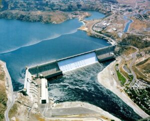
1918 story in the Wenatchee World that Bill Dietrich (former Columbian reporter and later with The Seattle Times) says in his wonderful 1995 book Northwest Passage — The Great Columbia River , “is probably the single most famous newspaper article in Pacific Northwest history. . . It is generally credited for launching the long debate about Grand Coulee Dam.” Students, fans and the mildly curious about any or all of: Grand Coulee Dam, The Columbia River, the massive Columbia Basin irrigation project, Eastern Washington in general, Washington state history, will find this article interesting.

Do you ever hear the Led Zepplin song “Kashmir” in your head when contemplating the Ice Age Floods? “I am a traveler of both time and space. To be where I have been” –Robert Plant, Led Zepplin’s Kashmir My 11-year old daughter and I are on a 5-day, 4-night raft trip on the Lower Salmon river and we are having the time of our lives! Sun, sand, water, lovely food, games and some of the finest nicest Eastern Oregonians we have ever met. One of the guides is a sensitive and strapping young man who is a student at U of Oregon. He’s both an English major and a Geology major. What do you with that? You write about the soul of the earth, true love and adventure, river stories, deep thoughts that cross scientific paradigms. I see him becoming a teacher someday, maybe a science teacher like his Dad. And he’s a kayaker like me. What is so amazing about the Eastern Oregon guides is their familiarity with, connection to, and love of the river and land. They don’t fight traffic or get on the morning commute treadmill every day. There are no stoplights in the whole of Wallowa County, and the only food franchise is a Subway sandwich shop, no Costco or Walmart. Sure, they have school and work, but they are connected to and love the land they live on in deeper ways that us city folks miss. They are here to tell us about the land. They are guides. The 4th day on the river we pass a group of pillar-like rocks with beautiful symmetry. “That’s columnar basalt” my guide says, “The geologist who figured out the floods and travelled around these parts was J Harlan Bretz”. “J Harlan Bretz” I repeat, carefully, committing to memory. When I returned home to talk to my friend (who was a geology major at Wesleyan) about the trip, she replies “’J Harlan Bretz,’ Oh yes, I have all his books!” An Amazon search and I begin by reading a biography of J Harlan Bretz, “Bretz’s Flood” by John Soennichsen- (some guy from Eastern Washington… hmmm). And guess what: It’s so well-written, I can’t put it down! I am enthralled cover-to-cover with the character of J Harlan Bretz, his teaching method of taking students to the field (and floating them downstream on large Sequoia logs, upon occasion), his love of life, the serendipity of his study of the USGS Quincy Basin topo map when it first published, many summers spent driving around and measuring the Channeled Scablands, presenting his field evidence and theories at the Cosmos Club in Washington DC, and most of all his ability to KNOW he was RIGHT when all his colleagues scoffed and dismissed his theories. Now THAT man was a pillar of strength. Perhaps like a column of basalt? If he were alive today, Harlan Bretz could stand up to money-motivated physicians – the bad kind, nepotism in the school district, gossipers and bullies, and other types of corruption, all of which I have had to do to defend my younger child against since. J Harlan Bretz helped me to do this. He was a GREAT man! “All I see turns to brown.. And fills my eyes with sand as I try not see the wasted land” – Kashmir by Led Zepplin What was it about those floods, biblical in nature, that left behind a story of such jaw-dropping inspiration? Who are these people who live in Eastern Oregon and Washington and are so inspired by the landscapes there they are called to find new ways to study it, publish, write fantastic biographies? I continued my search to find other scholars of the Ice Age Floods, and that led me next to Nick Zentner and Bruce Bjornstadt. To be continued…
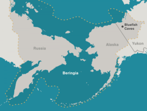
Archaeologists have long debated how and when people entered the Americas. Throughout the 20th century, the mainstream hypothesis was that the Clovis people were the first to pass into Alaska about 13,000 years ago. Stemming from his excavations between 1977 and 1987 at the Bluefish Caves in northwestern Yukon, Jacques Cinq-Mars, a Canadian archaeologist, unearthed evidence that hunters were using the site some 24,000 years ago. Lauriane Bourgeon, a French archaeologist, has spent much of her career re-examining and dating the Bluefish Caves collection to clarify the history of the contentious site. Her research has shown that at least 15 bones from the Bluefish Caves were cut-marked by people as early as 23,500 years ago.
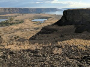
Steamboat Rock lies at the very northern end of the Grand Coulee. At over 1 mile long, ⅔ mile wide, and 800 feet high. The basalt-topped butte standing alone in the middle of the coulee, almost completely surrounded by the waters of Banks Lake is an incredible sight. It was left behind by erosion of both the Ice Age Floods that carved the Grand Coulee, and the Okanogan Lobe of the ice-age continental ice sheet. Because this area is near the thinning outer margin of the Columbia River Basalt extent, it’s easy to see Columbia River Basalt directly overlying older granitic basement from the trails around the base. A steep climb on a well constructed trail leads to the broad top of Steamboat Rock where the views are truly expansive, encompassing a full 360° panorama. It’s also easy to find granitic erratics and glacial till atop the butte that attest to the fact that the Okanagan Lobe overrode Steamboat Rock during the most recent Ice-Age glacial advance. The campgrounds at the State Park are spacious and well laid out. There is easy access to both the trails and to Banks Lake for fishing, boating and swimming. Most of the water in Banks Lake has been pumped up from the Columbia River’s Lake Roosevelt, and impounded by a dam 20 miles south at Coulee City. Banks Lake is a key element in the Columbia Basin Project that supplies water for the verdant agricultural areas to the south in an otherwise quite dry, high desert environment. Some other interesting places to explore in the area include Northrup Canyon, Grand Coulee Dam, and the quixotic Gehrke Windmill Garden just north of Electric City.
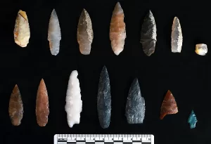
Oregon State University archaeologists have uncovered projectile points in Idaho that are thousands of years older than any previously found in the Americas, helping to fill in the history of how early humans crafted and used stone weapons. The 13 full and fragmentary projectile points, razor sharp and ranging from about half an inch to 2 inches long, are from roughly 15,700 years ago, according to carbon-14 dating. That’s about 3,000 years older than the Clovis fluted points found throughout North America, and 2,300 years older than the points previously found at the same Cooper’s Ferry site along the Salmon River in present-day Idaho. “From a scientific point of view, these discoveries add very important details about what the archaeologic al record of the earliest peoples of the Americas looks like,” said Loren Davis, an anthropology professor at OSU and head of the group that found the points. “It’s one thing to say, ‘We think that people were here in the Americas 16,000 years ago;’ it’s another thing to measure it by finding well-made artifacts they left behind.” Previously, Davis and other researchers working the Cooper’s Ferry site had found simple flakes and pieces of bone that indicated human presence about 16,000 years ago. But the discovery of projectile points reveals new insights into the way the first Americans expressed complex thoughts through technology at that time, Davis said. The Salmon River site where the points were found is on traditional Nez Perce land, known to the tribe as the ancient village of Nipéhe. The land is currently held in public ownership by the federal Bureau of Land Management. The points are revelatory not just in their age, but in their similarity to projectile points found in Hokkaido, Japan, dating to 16,000-20,000 years ago, Davis said. Their presence in Idaho adds more detail to the hypothesis that there are early genetic and cultural connections between the ice age peoples of Northeast Asia and North America. “The earliest peoples of North America possessed cultural knowledge that they used to survive and thrive over time. Some of this knowledge can be seen in the way people made stone tools, such as the projectile points found at the Cooper’s Ferry site,” Davis said. “By comparing these points with other sites of the same age and older, we can infer the spatial extents of social networks where this technological knowledge was shared between peoples.” These slender projectile points are characterized by two distinct ends, one sharpened and one stemmed, as well as a symmetrical beveled shape if looked at head-on. They were likely attached to darts, rather than arrows or spears, and despite the small size, they were deadly weapons, Davis said. “There’s an assumption that early projectile points had to be big to kill large game; however, smaller projectile points mounted on darts will penetrate deeply and cause tremendous internal damage,” he said. “You can hunt any animal we know about with weapons like these.” These discoveries add to the emerging picture of early human life in the Pacific Northwest, Davis said. “Finding a site where people made pits and stored complete and broken projectile points nearly 16,000 years ago gives us valuable details about the lives of our region’s earliest inhabitants.” The newly discovered pits are part of the larger Cooper’s Ferry record, where Davis and colleagues have previously reported a 14,200-year-old fire pit and a food-processing area containing the remains of an extinct horse. All told, they found and mapped more than 65,000 items, recording their locations to the millimeter for precise documentation. The projectile points were uncovered over multiple summers between 2012 and 2017, with work supported by a funding partnership held between OSU and the BLM. All excavation work has been completed and the site is now covered. The BLM installed interpretive panels and a kiosk at the site to describe the work. Davis has been studying the Cooper’s Ferry site since the 1990s when he was an archaeologist with the BLM. Now, he partners with the BLM to bring undergraduate and graduate students from OSU to work the site in the summer. The team also works closely with the Nez Perce tribe to provide field opportunities for tribal youth and to communicate all findings. The findings were published in the journal Science Advances. Reprinted from Oregon State University Newsroom, STORY BY: Molly Rosbach, SOURCE: Loren Davis
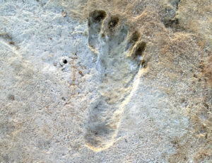
Articles in Science Alert and the New York Times report on a well documented age for many sets of human footprints as old as 23,000 years in the ancient lake shore sands of White Sands, New Mexico. “The footprints were first discovered in 2009 by David Bustos, the park’s resource program manager. Over the years, he has brought in an international team of scientists to help make sense of the finds. Together, they have found thousands of human footprints across 80,000 acres of the park. One path was made by someone walking in a straight line for a mile and a half. Another shows a mother setting her baby down on the ground. Other tracks were made by children.” Beginning in 2019, two United States Geological Survey (USGS) research scientists, Dr. Jeffrey Pigati and Kathleen Springer, began working on the site and found ancient seeds of ditch grass associated with various sets of footprints. The oldest footprints so far have been found in seed beds radiocarbon age-dated as old as 22,800 years, and the youngest footprints dated to about 21,130 years ago. Some scientists still have concerns the seeds might have absorbed older carbon from the lake waters. But in general this research is strongly indicative that humans were present in the Americas long before the generally accepted 15,600-year-old footprint found in Chile or the 13,000 year age of human tools found near Clovis, NM. If humans were well established in New Mexico 23,000 years ago, they must have started spreading down from Alaska long before that. “That starts to wind back the clock,” said Dr. Reynolds of Bournemouth University. Some researchers feel the migration might have been along the coast during the last major ice advance of the Pleistocene, while others argue people could have traveled inland more than 32,000 years ago, before Ice Age glaciers reached their maximum extent and blocked off that route. Regardless of the possible migration route, this new evidence opens up new possibilities that humans may have been present in our local area even before the earliest of the Ice Age Floods, about 18,000 years ago. While the floods could have wiped away most traces of early people in the area, the window of human habitation may be much greater than scientifically documented to date.
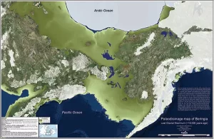
By reconstructing the sea level history of the Bering Strait, scientists found that the strait remained flooded and the Bering Land Bridge connecting Asia to North America did not emerge until around 35,700 years ago, less than 10,000 years before the height of the last ice age (known as the Last Glacial Maximum), and not long before humans are thought to have begun migrating into the Americas. The new findings indicate that the growth of the ice sheets—and the resulting drop in sea level—occurred surprisingly quickly and much later in the glacial cycle than previous studies had suggested. “It means that more than 50 percent of the global ice volume at the Last Glacial Maximum grew after 46,000 years ago,” said Tamara Pico, assistant professor of Earth and planetary sciences at UC Santa Cruz and a corresponding author of the paper. “This is important for understanding the feedbacks between climate and ice sheets, because it implies that there was a substantial delay in the development of ice sheets after global temperatures dropped.” Global sea levels drop during ice ages as more and more of Earth’s water gets locked up in massive ice sheets, but the timing of these processes has been hard to pin down. During the Last Glacial Maximum, which lasted from about 26,500 to 19,000 years ago, ice sheets covered large areas of North America. Dramatically lower sea levels uncovered a vast land area known as Beringia that extended from Siberia to Alaska and supported herds of horses, mammoths, and other Pleistocene fauna. As the ice sheets melted, the Bering Strait became flooded again around 13,000 to 11,000 years ago. The new findings are interesting in relation to human migration because they shorten the time between the opening of the land bridge and the arrival of humans in the Americas. The timing of human migration into North America remains unresolved, but some studies suggest people may have lived in Beringia throughout the height of the ice age. “People may have started going across as soon as the land bridge formed,” Pico said. The new study used an analysis of nitrogen isotopes in seafloor sediments to determine when the Bering Strait was flooded during the past 46,000 years, allowing Pacific Ocean water to flow into the Arctic Ocean. First author Jesse Farmer at Princeton University led the isotope analysis, measuring nitrogen isotope ratios in the remains of marine plankton preserved in sediment cores collected from the seafloor at three locations in the western Arctic Ocean. Because of differences in the nitrogen composition of Pacific and Arctic waters, Farmer was able to identify a nitrogen isotope signature indicating when Pacific water flowed into the Arctic. Pico, whose expertise is in sea level modeling, then compared Farmer’s results with sea level models based on different scenarios for the growth of the ice sheets. “The exciting thing to me is that this provides a completely independent constraint on global sea level during this time period,” Pico said. “Some of the ice sheet histories that have been proposed differ by quite a lot, and we were able to look at what the predicted sea level would be at the Bering Strait and see which ones are consistent with the nitrogen data.” The results support recent studies indicating that global sea levels were much higher prior to the Last Glacial Maximum than previous estimates had suggested, she said. Average global sea level during the Last Glacial Maximum was about 130 meters (425 feet) lower than today. The actual sea level at a particular site such as the Bering Strait, however, depends on factors such as the deformation of the Earth’s crust by the weight of the ice sheets. “It’s like punching down on bread dough—the crust sinks under the ice and rises up around the edges,” Pico said. “Also, the ice sheets are so massive they have gravitational effects on the water. I model those processes to see how sea level would vary around the world and, in this case, to look at the Bering Strait.” The findings imply a complicated relationship between climate and global ice volume and suggest new avenues for investigating the mechanisms underlying glacial cycles. In addition to Pico and Farmer, the coauthors include Ona Underwood and Daniel Sigman at Princeton University; Rebecca Cleveland-Stout at the University of Washington; Julie Granger at the University of Connecticut; Thomas Cronin at the U.S. Geological Survey; and François Fripiat, Alfredo Martinez-Garcia, and Gerald Haug at the Max Planck Institute for Chemistry in Germany. This work was supported by the National Science Foundation. Published in Proceedings of the National Academy of Sciences. Reprinted from UC Santa Cruz Newsletter, By Tim Stephens

There is considerable controversy regarding when humans first migrated into the Americas and whether they might have been in the local area during any of the Ice Age Floods. This 2016 video, produced by reputable sources, doesn’t answer that question, but it is an interesting and instructive visualization of human migration paths and timing over the past 200,000 years.

Using detailed fossil comparison techniques, scientists have been able to identify a giant new saber-toothed cat species, Machairodus lahayishupup, which would have prowled around the open spaces of North America between 5 and 9 million years ago. One of the biggest cats ever discovered, M. lahayishupup is estimated in this new study to have a body mass of some 274 kilograms (604 pounds) or so, and possibly even bigger. It’s an ancient relative of the well-known Smilodon, the so-called saber-toothed tiger. A total of seven M. lahayishupup fossil specimens, including upper arms and teeth, were analyzed and compared with other species to identify the new felid, with the fossils collected from museum collections in Oregon, Idaho, Texas, and California. Upper arms are crucial in these cats for killing prey, and the largest upper arm or humerus fossil discovered in the study was about 1.4 times the size of the same bone in a modern-day lion. That gives you an idea of just how hefty and powerful M. lahayishupup would have been. “We believe these were animals that were routinely taking down bison-sized animals,” says paleontologist Jonathan Calede from Ohio State University. “This was by far the largest cat alive at that time.” Rhinoceroses would have been abundant at the same and may have been animals that M. lahayishupup preyed on, alongside camels and sloths significantly bigger than the ones we’re used to today. Peering back so many millions of years into the past isn’t easy, and the researchers say that a more detailed saber-tooth cat family tree is going to be needed to work out exactly where this species fits in. The findings also open up some interesting evolutionary questions about these giant cats. “It’s been known that there were giant cats in Europe, Asia, and Africa, and now we have our own giant saber-toothed cat in North America during this period as well,” says Calede. “There’s a very interesting pattern of either repeated independent evolution on every continent of this giant body size in what remains a pretty hyper-specialized way of hunting, or we have this ancestral giant saber-toothed cat that dispersed to all of those continents. It’s an interesting paleontological question.” Excerpted from SCIENCE ALERT article by DAVID NIELD8 MAY 2021
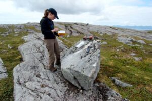
When and how did the first people come to the Americas? The conventional story says that the earliest settlers came via Siberia, crossing the now-defunct Bering land bridge on foot and trekking through Canada when an ice-free corridor opened up between massive ice sheets toward the end of the last ice age. But with recent archaeological evidence casting doubt on this thinking, scientists are seeking new explanations. One dominant, new theory: The first Americans took a coastal route along Alaska’s Pacific border to enter the continent. A new geological study provides compelling evidence to support this hypothesis. By analyzing boulders and bedrock, a research team led by the University at Buffalo shows that part of a coastal migration route became accessible to humans 17,000 years ago. During this period, ancient glaciers receded, exposing islands of southern Alaska’s Alexander Archipelago to air and sun — and, possibly, to human migration. The timing of these events is key: Recent genetic and archaeological estimates suggest that settlers may have begun traveling deeper into the Americas some 16,000 years ago, soon after the coastal gateway opened up. The research will be published online on May 30 in the journal Science Advances. “People are fascinated by these questions of where they come from and how they got there,” says lead scientist Jason Briner, PhD, professor of geology in UB’s College of Arts and Sciences. “Our research contributes to the debate about how humans came to the Americas. It’s potentially adding to what we know about our ancestry and how we colonized our planet.” “Our study provides some of the first geologic evidence that a coastal migration route was available for early humans as they colonized the New World,” says UB geology PhD candidate Alia Lesnek, the study’s first author. “There was a coastal route available, and the appearance of this newly ice-free terrain may have spurred early humans to migrate southward.” The findings do not mean that early settlers definitely traversed Alaska’s southern coast to spread into the Americas: The project examined just one section of the coast, and scientists would need to study multiple locations up and down the coastline to draw firmer conclusions. Still, the work is exciting because it hints that the seafaring theory of migration is viable. The bones of an ancient ringed seal — previously discovered in a nearby cave by other researchers — provide further, tantalizing clues. They hint that the area was capable of supporting human life at the time that early settlers may have been passing through, Briner says. The new study calculates that the seal bones are about 17,000 years old. This indicates that the region was ecologically vibrant soon after the ice retreated, with resources including food becoming available. Co-authors on the research included Briner; Lesnek; Charlotte Lindqvist, PhD, an associate professor of biological sciences at UB and a visiting associate professor at Nanyang Technological University; James Baichtal of Tongass National Forest; and Timothy Heaton, PhD, of the University of South Dakota. A landscape, touched by ice, that tells a story To conduct their study, the scientists journeyed to four islands within the Alexander Archipelago that lie about 200 miles south/southeast of Juneau. The team traveled by helicopter to reach these remote destinations. As soon as the researchers arrived, Briner knew that the islands had once been covered by ice. “The landscape is glacial,” he says. “The rock surfaces are smooth and scratched from when the ice moved over it, and there are erratic boulders everywhere. When you are a geologist, it hits you in the face. You know it immediately: The glacier was here.” To pinpoint when the ice receded from the region, the team collected bits of rock from the surfaces of boulders and bedrock. Later, the scientists ran tests to figure out how long the samples — and thus the islands as a whole — had been free of ice. The researchers used a method called surface exposure dating. As Lesnek explains, “When land is covered by a glacier, the bedrock in the area is hidden under ice. As soon as the ice disappears, however, the bedrock is exposed to cosmic radiation from space, which causes it to accumulate certain chemicals on their surface. The longer the surface has been exposed, the more of these chemicals you get. By testing for these chemicals, we were able to determine when our rock surfaces were exposed, which tells us when the ice retreated. “We use the same dating method for huge boulders called erratics. These are big rocks that are plucked from the Earth and carried to new locations by glaciers, which actually consist of moving ice. When glaciers melt and disappear from a specific region, they leave these erratics behind, and surface exposure dating can tell us when the ice retreated.” For the region that was studied, this happened roughly 17,000 years ago. The case for a coastal migration route In recent years, evidence has mounted against the conventional thinking that humans populated North America by taking an inland route through Canada. To do so, they would have needed to walk through a narrow, ice-free ribbon of terrain that appeared when two major ice sheets started to separate. But recent research suggests that while this path may have opened up more than 14,000 years ago, it did not develop enough biological diversity to support human life until about 13,000 years ago, Briner says. That clashes with archaeological findings that suggest humans were already living in Chile about 15,000 years ago or more and in Florida 14,500 years ago. The coastal migration theory provides an alternative narrative, and the new study may mark a step toward solving the mystery of how humans came to the Americas. “Where we looked at it, the coastal route was not only open — it opened at just the right time,” Lindqvist says. “The timing coincides almost exactly with the time in human history that the migration into the Americas is thought to have occurred.” The research was
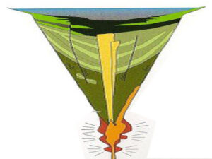
Palagonite Maar Just west of Hood River is a distinctive, short (<500 m) section of stratified orangeish oxidized volcanic tephra and highly fractured lava bombs. This mixture of oxidized volcanic particles ranging down to sub-micrometer sizes mixed with the larger lava bombs is a palagonite tuff. This deposit is the result of a “phreatic” eruption when lava erupted explosively from a volcanic vent through water, like a lake or groundwater. The rapid heating expansion of water to steam blew the rising lava out of the vent as tephra (volcanic rock fragments) ranging from ash-size to volcanic bombs (blobs of lava) up to several inches in diameter. Rapid oxidation of the water-quenched tephra turned the iron content to rust, producing the orangeish color of the tephra. The lava bombs were heavily fractured due to rapid cooling of the blob as it came in contact with the water and as it flew through the air. The tephra deposits dip inward on either side of a central gap toward the gap, with NE dips in the western section and NW dips in the eastern section, forming an inverted cone that converges downward toward the central gap. This feature is a “maar” deposit; an inverted cone of tephra and lava resulting from rapidly rising magma interacting with groundwater causing a steam-driven explosive eruption that builds the surrounding maar. The vent of this maar was in the area of the central gap.