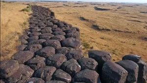
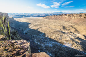
Relive Important Archive Articles

A large number of important articles get buried over time as new articles are added to our website, so here’s a chance to review and relive some of our most important articles. We think you might enjoy reviewing these timeless features.

The Cerutti Mastodon Site – A Bretz Type Controversy of Our Time

In March, while visiting San Diego, I went to the San Diego Museum of Natural History in Balboa Park and toured the remarkable Cerutti Mastodon Site exhibit. This controversial exhibit of a mastodon site is notable for its claim that the mastodon’s bones were broken by humans 130,000 years ago, making it far older than any other such site in North America. The signs at the beginning of the exhibit read as follows; “The Cerutti Mastodon discovery. A San Diego find reveals the earliest evidence of of human life in North America. In 1992, paleontologists from the San Diego Natural History Museum were surveying a highway construction site to identify and salvage any fossils that might be unearthed. “Field paleontologist Richard Cerutti spotted some bones and tusks. Exploring further, the team discovered that these were bones of a mastodon-an extinct relative of elephants. “But Richard noticed something unusual. The bones were mysteriously broken and the pieces separated. “It took 22 years for scientists to solve the riddle. Once they did, they realized that this local site is evidence of human presence on this continent 130,000 years ago-much earlier than we thought possible. “In 2014, scientists made a new discovery about the age of the Cerutti Mastodon Site. How did this happen? Scientists figured out the age of the mastodon bones using radiometric dating. It’s a way of telling how old a rock or fossil is by measuring its radioactive isotopes. “A radioactive isotope transforms into an isotope of a different element over time. If you know the rate at which the “parent” isotope transforms into its “daughter” isotope, measuring the parent-daughter ratio tells you how old the material is. “Scientists used a method that measures the ratio of the radioactive isotope uranium-234 to its daughter isotope thorium-230. Dramatic improvements in this method have made it a highly accurate means of dating very old materials- up to 500,000 years. In 2014, scientists used this method to date bones at the Cerutti Mastodon Site. “The results were clear. The bones are approximately 130,000 years old.” More than two decades after the Cerutti mastodon’s discovery in southern California in 1993, USGS scientist Dr. James Paces was sent several bones of unknown age. The specimens were important because they came from a site with abundant evidence of processing by ancient humans. Advances in analytical capabilities and the understanding of processes that incorporate natural uranium and its decay products in fossil bone provided archaeologists with a radiometric dating tool that, at least in some cases, could confidently and accurately determine ages for these older materials. After analyzing nearly 100 subsamples from multiple specimens, Dr. Paces determined that the mastodon bones—which were still fresh when someone fractured them using hammerstones and rock anvils—were covered with sediments 131,000 years ago, give or take about 9,000 years. This result indicates that some form of archaic humans arrived in the Americas more than 100,000 years earlier than scientists had thought possible. Following the dating of the bones officials at the Natural History Museum began making plans for a permanent exhibit about the discovery. The exhibit opened in 2017. It is very thorough and includes bones, alleged hammerstones, and anvil rocks from the original mastodon site as well as numerous photos and interpretive panels. When J Harlen Bretz first announced in the 1920’s his theory that the scablands of eastern Washington State had been carved out by a cataclysmic flood he met stiff opposition. What he was proposing was so far out of the mainstream of geological thinking of the time that many scientists couldn’t accept it. Schooled in uniformitarianism they believed that earth’s landforms were all created by slow gradual processes operating over time and that an event of the magnitude Bretz was proposing just wasn’t possible. They tried to come up with alternative explanations for the facts Bretz presented that fit in with their current frame of reference. Yale University geologist Richard Foster Flint famously said of certain flood features in the scablands that they presented “a picture of leisurely streams with normal discharge.” The claim by San Diego’s Natural History Museum that the Cerutti site is 130,000 years old is likewise far outside what many scientists of our time are ready to accept. Other similar sites are much younger. For example Sequim’s famous mastodon site is only 13,800 years old. If the San Diego Natural History Museum is correct it totally rewrites the history books about humans in North America. It places humans in North America during a previous interglacial period. It would establish that humans had long since been in North America during the time of the comparatively recent ice-age floods. Critics of the Natural History Museum, and there are many, point to things like what they consider to be a lack of lithics from the site. Others speculate that the signs of bone breakage observed at the site may have been caused by some other creature besides humans or by modern day construction equipment. But the Natural History Museum counters that none of the critics have provided a satisfactory alternative explanation for the evidence that they’ve presented. Cerutti and his team of researchers and the San Diego Natural History Museum remain unequivocal in their conclusion: The Cerutti Mastodon Site is a 130,000 year old archaeological site. – by Mark Sundquist, Puget Lobe Chapter “Ideas without precedent are generally looked upon with disfavor and men are shocked if their conceptions of an orderly world are challenged.” J Harlen Bretz 1928 “Extraordinary claims require extraordinary evidence – each aspect requires the strongest scrutiny,” Chris Stringer

Read More »

Waning Pleistocene Ice Sheet Affected Megaflood Paths and Local Shorelines

Have you ever thought about the how the weight of the ice-age Cordilleran ice sheet might affect the underlying Earth’s crust. There is strong evidence that the crust was depressed hundreds of feet beneath the ice, and since the crust is relatively thin and rigid over a plastic aesthenosphere, that also caused the crust for some distance beyond the ice margins to tilt toward the ice sheet. A new modeling study explored how changes in topography due to the solid Earth’s response to ice sheet loading and unloading might have influenced successive megaflood routes over the Channeled Scablands between 18 and 15.5 thousand years ago. The modeling found that deformation of Earth’s crust may played an important role in directing the erosion of the Channeled Scabland. Results showed that near 18 thousand year old floods could have traversed and eroded parts of two major Channeled Scabland tracts—Telford-Crab Creek and Cheney-Palouse. However, as the ice-age waned and the ice sheet diminished 15.5 thousand years ago, crustal isostatic rebound may have limited megaflood flow into the Cheney–Palouse tract. This tilt dependent difference in flow between tracts was governed by tilting of the landscape, which also affected the filling and overspill of glacial Lake Columbia directly upstream of the tracts. These results highlight one impact of crustal isostatic adjustment on megaflood routes and landscape evolution. Other studies have shown that relative ice-age sea levels were over 300 feet lower worldwide due to the volume of water locked up in ice sheets. Typical depictions of the shoreface extent are generally based on a 300 ft. depth contour, but there is strong evidence that shorelines were up to 200+ ft. higher than present day in marine areas adjacent to ice sheets, again because the crust was depressed by the weight of the ice sheer. A more accurate representation might show a much narrower shoreface in ice-free areas nearer to the ice sheet margin. However, in the Haida Gwaii Strait at the margin of the ice sheet the lower thickness of the ice sheet meant that local shorelines were as much as 550 feet lower than they are today. This was because the much greater thickness of the center of the ice sheet served to push upwards areas at the edge of the continental shelf in a crustal forebulge. It is now widely thought that these emergent ice-free land areas might have provided a viable coastal migration corridor for early peoples making their way to the Americas from Asia during the Pleistocene.

Read More »

Traveling the Ice Age Floods National Geologic Trail

In September 2021 my wife and I took a trip to see what was new along the Ice Age Floods National Geologic Trail and visit some places we did not make it to in our very first trip in 2004. The IAFI chapter brochures were very helpful in learning what there was to see in each area. We also remembered a preview of the National Parks Service unigrid map brochure that will come out hopefully later this year, so be sure and get one when it debuts. The other excellent tool was the online interactive map on the Ice Age Floods Institute website (https://iafi.org/floodscapes/), where you can click on a spot and see a photo and description of the site. All are great planning tools. We drove to Missoula, Montana and stayed there a couple of days as we made day trips. Our first one was to Ovando to see a granite glacial erratic that the Glacial Lake Missoula Chapter had etched and placed at the high-water line. You will find it at Trixi’s Antler Saloon which is a nice place to grab a bite for lunch. The chapter has a number of these high water markers placed already and have more planned to show the full extent of Glacial Lake Missoula. Unfortunately, due to the smoke from the wildfires we were not able to go to Hamilton to see the 8-ton granite erratics outside Ravaili Museum with four interpretive signs outside and additional displays inside. We drove up to the Paradise Center in Paradise, Montana. We had been there before in 2016 for the fall IAFI field trip and they were just dreaming of what the old Paradise Elementary School could become. They have done a wonderful job of making that dream come true. It was one of our favorite spots on this trip. They have dedicated an entire room to the Ice Age Floods story where an extremely accurate 3-D map of Glacial Lake Missoula has lights installed so you can push a button to light up the edge of the ice lobe and other features. Besides information about the Ice Age Floods, the Center also has wonderful displays about the trains & train yard that used to be in Paradise and the history of the Paradise Elementary School. We went to the Natural History Museum in Missoula and enjoyed the panels and video which told the Lake Missoula Floods story and also about Joseph Pardee, a very important pioneer in solving the mystery of these Floods. This museum also displays an amazing amount of taxidermy showing the wildlife and birds in the region. On our way up to Sandpoint, Idaho we passed through Eddy Narrows. Glacial Lake Missoula drained through this canyon going 80 mph leaving horizontal marks high up on the walls. Previously these were thought to be glacial striations, but Pardee speculated that these marks were from huge boulders as they shot through the Narrows. The Narrows is long with few places you can pull over on Highway 200, so it can be hard to really appreciate its scope. We got a good view from the Koo-Koo-Sint Bighorn Sheep Viewing Interpretive Site which has several interpretive signs that talk about the sheep and the geology of the Clark Fork River Valley. We then went over to Farragut State Park at the southern tip of Lake Pend Oreille to view the beginning of the outburst plain that formed the Rathdrum/Spokane Valley aquifer. Across Lake Pend Oreille is Green Monarch Ridge; the terminus of the Purcell Trench which held the 4,000 ft. ice dam that carved the steep walls. The display at the museum has several interpretive panels. The next day we met Consuelo Larrabee who gave us a personal tour of the 40,000 square foot Ice Age Floods Playground in Riverfront Park in Spokane, Washington. She and Melanie Bell, the president of the Cheney-Spokane chapter, did an enormous amount of work as consultants on this fabulous, themed park.  Kids can learn as they play on the three-story Columbian slide tower, Glacial Dam splash pad, log jam climber, an alluvial deposit fossil dig, and more. The park was filled with kids and the adults were enjoying it as much as the kids. We loved watching the excitement of a child as she saw the splash pad water fountains simulate the ice dam starting to rupture and then the cascade of water flooding over the manmade basalt rocks. Along the side of the building are actual basalt columns and the fossil dig led to many exciting discoveries by the children as they dug through the sand to reveal embedded replicas of fossils. Throughout the park are thoughtfully placed benches for people to sit and watch the fun going on around them. There are nine interpretive panels throughout the park adding a wonderful educational benefit to all the fun. This park will be quite a prize for years to come. The next day we drove along Highway 262 to W. McManamon Road to the Drumheller Channels National Natural Landmark. This outlet from the Quincy Basin, with floodwaters going 65 mph eroded not just the topsoil but the underlying basalt which created dramatic channels, basins, potholes and buttes. The viewpoints along the drive had several interpretive panels talking about these wonderful vistas. Since we live in Portland and this trip was to see places we had not recently seen, we skipped over the many wonderful places in the Columbia River Gorge, Willamette Valley & Tualatin. But for your trip, please check out the hundreds of beautiful and interesting sites to see in this region. The last stop for this trip was Cape Disappointment. The Floods debris flushing out the mouth of the Columbia River added substantially to submarine Astoria Fan and sediment cores have shown that ocean currents carried some of this debris all the way down to Cape Mendocino, California. Although not visible from the surface, the Park display has a relief map that shows the Astoria Canyon

Read More »

The Grand Coulee – A Floods Poem

THE GRAND COULEE – A Floods Poem THE GRAND COULEE Older than legends,Younger than mountains,The earth remembersThe Great Inland Sea. And that Sea emptiedIn torrential furyNever imaginedEven in dreams. Down through the canyons,Flood of all riversCarving the couleesTime, time again. Roiled surging waters,Thunder of thunders,Swift toward the oceanReshaping the plain. Gone with the glaciersIs the great Lake Missoula,Gone from remembrance,Like mist in the wind. Yet the story is etchedIn the canyons and couleesLeft for those who imagineTo seek and to find. David Wahl January 4, 2002 Lower Grand Coulee Upper Grand Coulee at Steamboat Rock (left)

Read More »

The Washington 100 Geotourism Guide

Check out this video about the Washington 100, a cool new geotourism website by the Washington Geological Survey featuring 100 places to experience amazing geology in Washington State. Then explore the website itself at wa100.dnr.wa.gov 

Read More »

First Americans Toxic Debate Hobbled Archaeology for Decades

Bluefish Caves directly challenged mainstream scientific thinking. Evidence had long suggested that humans first reached the Americas around 13,000 years ago, when Asian hunters crossed a now submerged landmass known as Beringia, which joined Siberia to Alaska and Yukon during the last ice age. From there, the migrants seemed to have hurried southward along the edges of melting ice sheets to warmer lands in what is now the United States, where they and their descendants thrived. Researchers called these southern hunters the Clovis people, after a distinctive type of spear point they carried. And the story of their arrival in the New World became known as the Clovis first model. Jacques Cinq-Mars, however, didn’t buy that story—not a bit.

Read More »

New Saber-Toothed Cat Species May Have Hunted Rhinos in America

Using detailed fossil comparison techniques, scientists have been able to identify a giant new saber-toothed cat species, Machairodus lahayishupup, which would have prowled around the open spaces of North America between 5 and 9 million years ago. One of the biggest cats ever discovered, M. lahayishupup is estimated in this new study to have a body mass of some 274 kilograms (604 pounds) or so, and possibly even bigger. It’s an ancient relative of the well-known Smilodon, the so-called saber-toothed tiger. A total of seven M. lahayishupup fossil specimens, including upper arms and teeth, were analyzed and compared with other species to identify the new felid, with the fossils collected from museum collections in Oregon, Idaho, Texas, and California. Upper arms are crucial in these cats for killing prey, and the largest upper arm or humerus fossil discovered in the study was about 1.4 times the size of the same bone in a modern-day lion. That gives you an idea of just how hefty and powerful M. lahayishupup would have been. “We believe these were animals that were routinely taking down bison-sized animals,” says paleontologist Jonathan Calede from Ohio State University. “This was by far the largest cat alive at that time.” Rhinoceroses would have been abundant at the same and may have been animals that M. lahayishupup preyed on, alongside camels and sloths significantly bigger than the ones we’re used to today. Peering back so many millions of years into the past isn’t easy, and the researchers say that a more detailed saber-tooth cat family tree is going to be needed to work out exactly where this species fits in. The findings also open up some interesting evolutionary questions about these giant cats. “It’s been known that there were giant cats in Europe, Asia, and Africa, and now we have our own giant saber-toothed cat in North America during this period as well,” says Calede. “There’s a very interesting pattern of either repeated independent evolution on every continent of this giant body size in what remains a pretty hyper-specialized way of hunting, or we have this ancestral giant saber-toothed cat that dispersed to all of those continents. It’s an interesting paleontological question.” Excerpted from SCIENCE ALERT article by DAVID NIELD8 MAY 2021

Read More »

Indigenous Flood Stories from 14,000 Years Ago

On October 7th at Chief Timothy Park near Clarkston, WA at the latest Confluence Story Gathering,  Thomas Morning Owl (Umatilla tribe) noted there are indigenous people’s stories of massive floods going back to 14,000 years ago. While he didn’t elaborate, it would be very interesting to have these stories shared as first-hand accounts of the Ice Age and/or Bonneville Floods. Confluence Story Gatherings are designed to elevate native voices in our understanding of the Columbia River system. This Confluence Story Gathering explored stories and perspectives from Nez Perce homelands, where a panel of indigenous thinkers and storytellers — Allen Pinkham, Sr. (Nez Perce), Thomas Morning Owl (Umatilla) and Jefferson Greene (Warm Springs) — shared their observations. Despite the strong winds, rain and even hail, the stories prevailed. Confluence Project is a community supported nonprofit that connects people to place through art and education. We work in collaboration with Northwest communities, tribes and celebrated artist Maya Lin to create reflective moments that can shape the future of the Columbia River system. We share stories of this river through six public art installations, educational programs, community engagement and a rich digital experience. The six projects span 438 miles from the mouth of the Columbia River to the gateway to Hell’s Canyon, with sites in both Oregon and Washington. These are “teachable places,” transformed and reimagined to explore the confluence of history, culture and ecology in our region. Each work references a passage from the Lewis and Clark journals as a snapshot in time, while comparing it with the deeper story.

Read More »

Share this article:

Like this:

Like Loading...