Jökulhlaups in Alaska’s Wrangell-St. Elias National Park
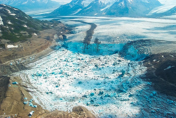
A recent Smithsonian Magazine article gives some interesting insights to present-day Jökulhlaups (glacial outburst floods) that are but minuscule relatives of the cataclysmic Ice Age Floods. Iceberg Lake was on the edge of a western tributary of the Tana Glacier, but in 1999 the lake suddenly vanished. Dammed on its southern end by ice, the water, with persistently warming temperatures, had bored a hole under the ice and escaped through tunnels to emerge ten miles away and empty into the Tana River. The sudden drainage of a glacier-dammed lake is not uncommon. “Some lakes in Wrangell-St. Elias regularly drain,” Loso said. Hidden Creek Lake, for instance, near McCarthy, drains every summer, pouring millions of gallons through channels in the Kennicott Glacier. The water gushes out the terminus of the Kennicott, causing the Kennicott River to flood, an event called a jokulhlaup—an Icelandic word for a glacial-lake outburst flood. “The Hidden Creek jokulhlaup is so reliable,” said Loso, “it has become one of the biggest parties in McCarthy.” But the disappearance of Iceberg Lake was different, and unexpected. It left an immense trench in the ground, the ghost of a lake, and it never filled up again. The roughly six-square-mile mudhole turned out to be a glaciological gold mine. The mud, in scientific terms, was laminated lacustrine sediment. Each layer represented one year of accumulation: coarse sands and silts, caused by high runoff during the summer months, sandwiched over fine-grained clay that settled during the long winter months when the lake was covered in ice. The mud laminations, called varves, look like tree rings. Using radiocarbon dating, Loso and his colleagues determined that Iceberg Lake existed continuously for over 1,500 years, from at least A.D. 442 to 1998. “In the fifth century the planet was colder than it is today,” Loso said, “hence the summer melt was minimal and the varves were correspondingly thin.” The varves were thicker during warmer periods, for instance from A.D. 1000 to 1250, which is called the Medieval Warming Period by climatologists. Between 1500 and 1850, during the little ice age, the varves were again thinner—less heat means less runoff and thus less lacustrine deposition. “The varves at Iceberg Lake tell us a very important story,” Loso said. “They’re an archival record that proves there was no catastrophic lake drainage, no jokulhlaup, even during the Medieval Warming Period.” In a scientific paper about the disappearance of Iceberg Lake, Loso was even more emphatic: “Twentieth-century warming is more intense, and accompanied by more extensive glacier retreat, than the Medieval Warming Period or any other time in the last 1,500 years.” Loso scratched his grizzled face. “When Iceberg Lake vanished, it was a big shock. It was a threshold event, not incremental, but sudden. That’s nature at a tipping point.” One of the most startling, and devastating, consequences of this rapid melting of the ice was the Icy Bay landslide. The Tyndall Glacier, on the southern coast of Alaska, has been retreating so quickly that it is leaving behind steep, unsupported walls of rock and dirt. On October 17, 2015, the largest landslide in North America in 38 years crashed down in the Taan Fjord. The landslide was so enormous it was detected by seismologists at Columbia University in New York. Over 200 million tons of rock slid into the Taan Fjord in about 60 seconds. This, in turn, created a tsunami that was initially 630 feet high and roared down the fjord, obliterating virtually everything in its path even as it diminished to some 50 feet after ten miles. “Alder trees 500 feet up the hillsides were ripped away,” Anderson says. “Glacial ice is buttressing the mountainsides in Alaska, and when this ice retreats, there is a good chance for catastrophic landslides.” In other ranges, such as the Alps and the Himalaya, he says, the melting of “ground ice,” which sort of glues rock masses to mountainsides, can release enormous landslides into populated valleys, with devastating consequences. “For most humans, climate change is an abstraction,” Loso says when I meet him in his office, which is down a long, dark, heavily beamed mine building in Kennecott. “It’s moving so slowly as to be basically imperceptible. But not here! Here glaciers tell the story. They’re like the world’s giant, centuries-old thermometers.” Read the entire article “A Daring Journey Into the Big Unknown of America’s Largest National Park” online at SmithsonianMag.com
NASA Image of the Day: Channeled Scablands
To the non-geologist, the landforms on the Columbia Plateau in eastern Washington might look more like another planet than Earth. Boulders lie strewn across the landscape, amid towering cliffs and plunging holes. Winding channels scar the bedrock. Through the eyes of a geologist, however, the landforms of the so-called Channeled Scablands reveal a past punctuated by violent floods. The network of channels is visible in a natural-color image (below) derived from the Operational Land Imager (OLI) on Landsat 8. The image is a “best-pixel mosaic,” which means it is composed of small parts of many images captured between 2013 and 2018. The technique makes it possible to strip away clouds and haze. The mosaic was then draped over data from NASA’s Shuttle Radar Topography Mission (SRTM) to show the topography. The channels appear dark brown compared to lighter surrounding areas, but they are not wet. (The water-filled Snake and Columbia Rivers are much darker by comparison.) Instead, these channels take on a dark color because the overlying loess has been eroded, exposing underlying volcanic basalt. The massive prehistoric floods that eroded this landscape were not always obvious to scientists. Geologist J Harlen Bretz described in 1923 how water could have sculpted the features. “The channeled scablands are the erosive record of large, high-gradient, glacier-born streams,” he wrote in a research paper. He added: “The magnitude of the erosive changes wrought by these glacial streams is nothing short of amazing.” But for decades, his explanation remained controversial. Scientists have since gained an even better understanding of the events that took place during the last Ice Age 10,000 to 20,000 years ago. As the edge of the Cordilleran ice sheet advanced southward, it formed an ice dam rising about 600 meters (2,000 feet) high along the Clark Fork River. Glacial Lake Missoula grew behind the ice dam and ultimately contained as much water as Lake Erie and Lake Ontario combined. When the dam broke, more than 500 cubic miles of water tore across the region at about 80 miles per hour. The dam grew and broke several times, and the repeated flooding carved out grooves, potholes, and the long channels known as “coulees.” On September 2, 2017, the OLI on Landsat 8 acquired this detailed image of Potholes Coulee. This horseshoe-shaped canyon was formed when floodwaters dropped more than 260 meters (850 feet) in less than 5 kilometers (3 miles) from the Quincy Basin to the Columbia River Valley, stripping away topsoil and eroding the basalt. In modern times, irrigation networks that pull water from the Columbia River have made agriculture productive in places where this rich soil remains. References and Related Reading Bretz, J.H. (1923) The Channeled Scablands of the Columbia Plateau. The Journal of Geology 31(8), 617–649. NASA Earth (2012, February 16) The Legacy of the Megaflood. Accessed April 18, 2018. National Geographic (2017, March 9) Formed by Megafloods, This Place Fooled Scientists for Decades. Accessed April 18, 2018. The Pleistocene Post (2011) Potholes Coulee. Accessed April 18, 2018. The Seven Wonders of Washington State (2015) The Channeled Scablands. Accessed April 18, 2018. Texas University at Austin (1978, June) The Channeled Scabland. Accessed April 18, 2018. U.S. Department of the Interior, Bureau of Reclamation, Columbia Basin Project. Accessed April 18, 2018. NASA Earth Observatory images by Joshua Stevens, using Landsat data from the U.S. Geological Survey and topographic data from the Shuttle Radar Topography Mission (SRTM). Story by Kathryn Hansen. Reprinted from Earth Observatory Instrument(s): Space Shuttle – SRTM Landsat 8 – OLI
6 New ‘Nick On The Rocks’ Episodes
6 new short episodes of ’Nick On The Rocks’ aired on PBS this past winter! Each of these gems are short enough to be taken in by even the busiest of us, and yet have enough information to whet the appetite of even the most intensive of us. Nick is masterful in his presentations and who he draws in to help. Watch them all, you won’t be disappointed. Lake Chelan – Battle of the Ice Sheets (w/ Chris Mattinson) Click HERE to watch. 5 minutes. Chasing Ancient Rivers (w/ Steve Reidel) Click HERE to watch. 5 minutes. Seattle Fault (w/ Sandi Doughton) Click HERE to watch. 5 minutes. Bridge of the Gods Landslide (w/ Jim O’Connor) Click HERE to watch. 5 minutes. Columns of Basalt Lava Click HERE to watch. 5 minutes. Ancient Volcanoes in the Cascades (w/ Daryl Gusey) Click HERE to watch. 5 minutes.
Central Oregon Geoscience Society (COGS) Formed
The Central Oregon Geoscience Society (COGS) has formed as a central-Oregon based, non-profit organization promoting a greater awareness and understanding of the geological sciences through technical presentations, field trips and educational outreach to schools. Plans are to have 8 presentations per year (5 in the spring, 3 in the fall), field trips in the late spring through early fall. Presentations are held at Deschutes Brewery Tap Room (upstairs), 1044 NW Bond Street in Bend. Join us at 6:00 PM for food and beverages, presentation at 7:00 PM. COGS held its inaugural presentation on March 27 with Bart Wills, U.S. Forest Service, speaking on Geothermal Exploration at Newberry Volcano. The next presentation will be on April 24th with Adam Kent, Oregon State University, speaking on Mount Hood: Confessions of an interesting Boring Volcano. Bob Jensen will lead COGS’s inaugural field trip in April exploring the geology of the upper and lower loop trails in Riley Ranch Nature Reserve. This trip will allow a look into the Deschutes River channel where over five million years of Central Oregon’s geologic past are exposed. The wide variety of volcanic and erosional features within the Riley Ranch Nature Reserve makes it one of the most geologically interesting park in the Bend Park & Recreation District system. Keep abreast of upcoming plans via the website CoGeoSoc.org.
13,000 Year-Old Human Footprints Found on BC Island
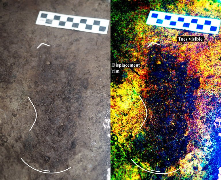
Big feet. Little feet. A heel here. A toe there. A digitally enhanced photo of a footprint found at Calvert Island, British Columbia that researchers dated to 13,000 years old. Credit Duncan McLaren Stamped across the shoreline of Calvert Island, British Columbia, are 13,000-year-old human footprints that archaeologists believe to be the earliest found so far in North America. The finding, which was published Wednesday in the journal PLOS One, adds support to the idea that some ancient humans from Asia ventured into North America by hugging the Pacific coastline, rather than by traveling through the interior. “This provides evidence that people were inhabiting the region at the end of the last ice age,” said Duncan McLaren, an anthropologist at the Hakai Institute and University of Victoria in British Columbia and lead author of the study. “It is possible that the coast was one of the means by which people entered the Americas at that time.” Dr. McLaren and his colleagues stumbled upon the footprints while digging for sediments beneath Calvert Island’s beach sands. Today, the area is covered with thick bogs and dense forests that the team, which included representatives from the Heiltsuk First Nation and Wuikinuxv First Nation, could only access by boat. At the close of the last ice age, from 11,000 to 14,000 years ago, the sea level was six to ten feet lower. The footprints were most likely left in an area that was just above the high tide line. “As this island would only have been accessible by watercraft 13,000 years ago,” Dr. McLaren said, “it implies that the people who left the footprints were seafarers who used boats to get around, gather and hunt for food and live and explore the islands.” They found their first footprint in 2014. While digging about two feet beneath the surface in a 20-square-inch hole, they saw an impression of something foot-shaped in the light brown clay. In 2015 and 2016, they returned and expanded the muddy pit. They discovered several more steps preserved in the sediment. The prints were of different sizes and pointed in different directions. Most were right feet. When the team was finished they had counted 29 in total, possibly belonging to two adults and a child. Each was barefoot. The researchers think that after the people left their footprints on the clay, their impressions were filled in by sand, thick gravel and then another layer of clay, which may have preserved them. Using radiocarbon dating on sediment from the base of some footprint impressions, as well as two pieces of preserved wood found in the first footprint, Dr. McLaren and his team found them to be 13,000 years old. That would make them the oldest preserved human footprints in North America. “It’s not only the footprints themselves that are spectacular and so rare in archaeological context, but also the age of the site,” said Michael Petraglia, an archaeologist from the Max Planck Institute for the Science of Human History in Germany who edited the paper for PLOS One but was not involved in the work. “It suggests an early entrance into the Americas.” Dr. Petraglia said the footprints also provided strong evidence for the coastal movement hypothesis and he added that they may have traveled the so-called “Kelp Highway,” a hypothesis that underwater kelp forests supported ecosystems down the North Pacific coast that helped ancient seafaring people hunt, develop and migrate. “The work is important because it shows the ‘real’ people, not just artifacts or skeletal remains,” said Steve Webb, a biological archaeologist at Bond University in Australia. “However, the footprints are limited in number and don’t shed light on activities or movement that tell us very much.” He added that future hunts for footprints should keep in mind that not everyone from this time period walked around barefoot. If anthropologists are too busy searching for soles, toes and arches, they might miss clues from those who wore animal skin shoes. Reprinted from New York Times – Earliest Known Human Footprints in North America Found on Canadian Island By NICHOLAS ST. FLEUR, March 28, 2018
ESA Maps a Lava Tube for Moon and Mars Expeditions
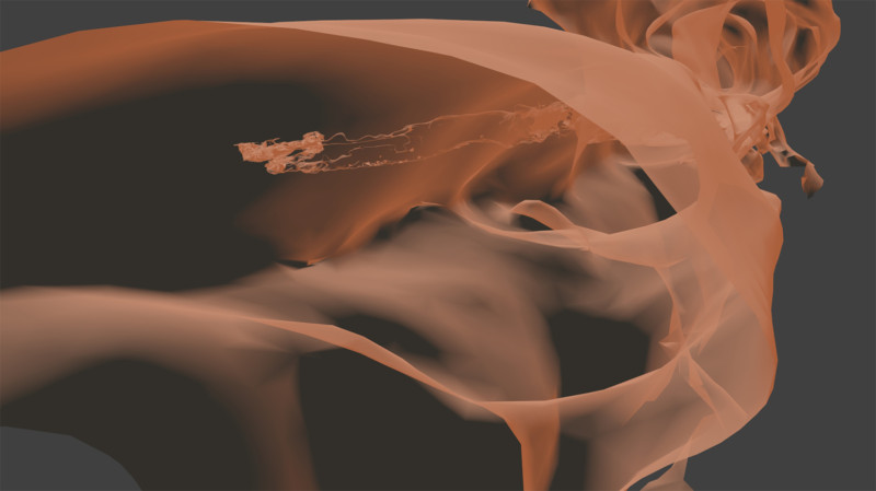
With all deference to the book and movie “The Martian”, wouldn’t you, as part of an interplanetary expedition, prefer to be protected from the radiation, micro-meteorites and extreme temperature fluctuations of the Moon or Martian surface? Though some of the hazards depicted in “The Martian” are way over-dramatized (the thin Martian atmosphere wouldn’t sustain the depicted raging storms), there are still hazards aplenty on the surface. So why not site your habitat in a cozy lava tube, protected from many of those surface nasties. At least that’s some of the reasoning behind a European Space Agency (ESA) effort to map a portion of Spanish lava tube in centimeter-scale detail as part of the ESA’s 2017 Pangaea-X campaign. Some chambers in the 8 km long La Cueva de los Verdes lava tube are large enough to hold residential streets and houses (or a prototype Martian research station/habitat). In less than 3 hours the cave research team mapped the lava tube using the smallest and lightest imaging scanner on the market and a wearable backpack mapper that collects geometric data without a satellite and synchronizes images collected by five cameras and two 3D imaging laser profilers. While the data is still being analyzed, ESA has released this ghostly fly-thru of a 1.3 km portion of the lava tube. Click the play button and prepare to take a pseudo-trip to Mars. So, the next time you visit a cave or lava tube, especially a large one, imagine yourself in a spacesuit on the Moon or Mars and realize that you’re actually an inner-space explorer. But don’t be too surprised at the creatures you may run into, they’re just other inner-space explorers too.
If You Have A Story, We Want to Hear It!
Our members come from varied and interesting walks of life, yet one bond that we share is our interest in the Ice Age Floods. Whether we’re captivated by the compelling stories of the floods, or the magnificent landscapes they helped create, or wanting to understand what’s behind the land we live in, we all share this common bond. And we all have experiences, insights and passions that would also interest others who share this bond. The IAFI website and newsletter are always on the lookout for short articles and captivating images related to these experiences, insights and passions that can, and probably should be shared with others. We encourage you to occasionally take a moment to share a short ‘floods’ story about your favorite place, or something you’ve done, or even what the floods places and stories have meant to you. We also want to share news, information and stories from all our widespread chapter areas, so your contributions can help others find, experience or think about something or some place they might have not been aware of before. We’re interested in short articles, longer than a Facebook post but generally shorter than a magazine article (100-500 words), that even loosely relate to the Ice Age Floods. For example, we’ve featured articles about field excursions, special places to be visited, shared experiences, technical notes, even stories about love found through the IAFI. And don’t worry if you’re not a ‘writer’, our editors will gently mold your story to enhance and fit it to our formats. Also, since images are often worth a thousand words, we strongly encourage you to include a compelling image or two that help tell the story. Just email the story and mages to Newsletter@IAFI.org, and thank you for sharing.
What’s Beneath Our Feet?

“Beneath Our Feet: Mapping the World Below” plumbs the depths of the question, “What’s beneath our feet?” through maps, images and archaeological artifacts. The exhibition explores nearly 400 years of maps and objects in an attempt to find out why and how humans imagine subterranean landscapes including caves, mines and water tables. Colorful and complicated images reflect the biases of long past and recent days and the concerns of their authors, including the United States’ desire to appropriate the natural resources of Native American lands and a 17th-century Jesuit priest’s attempt to use Scripture to create a framework for Earth’s geology. Catch the exhibition online, including a bibliography, reading lists and a 3-D tour of the Boston Public Library’s Norman B. Leventhal Map Center gallery itself. As you explore nearly 400 years of maps and images of the world below, you can compare the historical viewpoint with the modern, and see how we have advanced our perception and depiction of what lies beneath.
Indigenous Flood Stories from 14,000 Years Ago
On October 7th at Chief Timothy Park near Clarkston, WA at the latest Confluence Story Gathering, Thomas Morning Owl (Umatilla tribe) noted there are indigenous people’s stories of massive floods going back to 14,000 years ago. While he didn’t elaborate, it would be very interesting to have these stories shared as first-hand accounts of the Ice Age and/or Bonneville Floods. Confluence Story Gatherings are designed to elevate native voices in our understanding of the Columbia River system. This Confluence Story Gathering explored stories and perspectives from Nez Perce homelands, where a panel of indigenous thinkers and storytellers — Allen Pinkham, Sr. (Nez Perce), Thomas Morning Owl (Umatilla) and Jefferson Greene (Warm Springs) — shared their observations. Despite the strong winds, rain and even hail, the stories prevailed. Confluence Project is a community supported nonprofit that connects people to place through art and education. We work in collaboration with Northwest communities, tribes and celebrated artist Maya Lin to create reflective moments that can shape the future of the Columbia River system. We share stories of this river through six public art installations, educational programs, community engagement and a rich digital experience. The six projects span 438 miles from the mouth of the Columbia River to the gateway to Hell’s Canyon, with sites in both Oregon and Washington. These are “teachable places,” transformed and reimagined to explore the confluence of history, culture and ecology in our region. Each work references a passage from the Lewis and Clark journals as a snapshot in time, while comparing it with the deeper story.
Share the Floods News That’s Fit to Print
Do you write and/or edit well? Do you like knowing what’s going on in your IAFI chapter? Do you think that news should be shared with others? Then we have a SMALL job for you that can be a BIG help for your chapter and for the Ice Age Floods Institute in general. Every IAFI chapter has news and events that should be shared with other chapter members and maybe other chapters. We have an active website, social media, and a newsletter to share them on. But sometimes the news and events can get skipped over when the chapter leaders get overloaded or may not be particularly comfortable with writing to inform and interest others. If you write well and can find a little time each month we will show you how you can easily help us get the word out about important news and events. As a result you’ll help your chapter grow and become more active, and you’ll be one of the first to know about news and events that are happening. If this sounds like something you can do to help your chapter, please contact your chapter president (if you’re not sure who that is, visit https://iafi.org/about-iafi/board-directory/) and we’ll get you plugged in.