Tualatin Ice Age Foundation Established
A Tualatin, Oregon Ice Age Foundation has been established to provide educational and economic opportunities for area residents, students, businesses and visitors. Local interest in ancient ice-age animals started in the 1970s when a Portland State University college student dug up half of a mastodon skeleton in Tualatin, which now is on display at the Tualatin Library along with several other ancient animal bones from such as mammoths, giant sloth, and bison. In 2018 a Foundation board was created to guide the foundation and raise funds for the center. The board includes Portland State University Geology Professor Emeritus Scott Burns as President; Yvonne Addington, Tualatin Historical Society; Linda Moholt, Executive Director of Tualatin Chamber of Commerce; Paul Hennon, retired Tualatin Parks Director; Jerianne Thompson, Tualatin Librarian; and Rick and Sylvia Thompson of the Ice Age Floods Institute, Lower Columbia chapter. Prior to the Foundation being established, an Ice Age Heritage Tourism Plan, funded by Washington County Visitor’s Association, which contained recommendations for further development by an international consultant, Bill Baker, owner of Total Destination Management. Baker recommended a new Ice Age Interpretive Center to house more of the collections and educate residents and visitors. According to Baker, “the Tualatin area was front and center for one of the greatest natural events of the last ice advance: a series of colossal floods that roared down the Columbia Gorge and pooled in the Tualatin and Willamette Valleys between 18,000 and 15,000 years ago. The entire Tualatin area landscape was shaped by those floods.” Baker saw important economic development, jobs and educational opportunities and recommended a new Tualatin Ice Age Foundation to implement opportunities and raise funds for a Tualatin Ice Age Interpretive Center. Portland State University, the University of Oregon and the Ice Age Floods Institute, Lower Columbia chapter have, for several years, been assisting the Tualatin Historical Society in seeking the prehistory of Tualatin. The National Park Service has identified Tualatin as a key Ice Age Floods National Geologic Trail hub. The City has continued their efforts to display their ice age prehistory by the development of the Tualatin River Greeway Trail and Fred Bruning, chief executive for Center Cal shopping centers, donating to the public, a $220,000 bronze statue of the Tualatin Mastodon. To date, many ancient animal bones and huge multi-ton erratics carried here by roaring floods have been found. Private donations of bones continue to be offered as we seek funding for this unusual historical project of building our interpretive center. Tualatin invites you to come see the displays and exhibits we already have at the library, Tualatin Heritage Center, in our parks and walkways and in the future in our Ice Age Interpretitive Center. For more information on Tualatin’s ice age history go to: https://tualatinchamber.com/visitor/ice-age/.
Ice Age Discovered – Stev Ominski
For Mountain residents the discovery of Stev Ominski’s art could be attributed to his Siamese cats, Lewis and Clark. Except the true discovery of Ominski’s work has gone far beyond. The Rhododendron resident’s recent work titled “Age’s End” depicts the classic view up the Columbia River Gorge during a Missoula Ice Age flood which occurred some 20,000 years ago. This work – 24 inches high, 48 inches wide, rendered by acrylic on canvas – attracted the attention of the Oregon Historical Society (OHS). “The collections manager (from OHS), Nicole Yasuhara, contacted me out of the blue and asked if they might use “Age’s End” to represent the Ice Age floods in Oregon for their new permanent exhibit Experience Oregon (which is) now open,” Ominski told The Mountain Times. “Of course, I was both pleased and honored to have been selected by OHS. They purchased a digital file and some limited use rights.” The recent discovery element didn’t end there. Shortly after that recognition Ominski was contacted by a graphic designer (Steve Johnston) who was working with a group at the State Capitol installing an exhibit on the roof of the dome and they thought Ominski’s depiction of the Ice Age floodwaters slamming into Beacon Rock would fit in nicely with the exhibit. “The Inundation of Beacon Rock” in the Columbia River Gorge is now a part of the east-facing interpretive panel on the capitol’s dome roof. “I’ve been working on this suite of Ice Age floods imagery for over 25 years with the help and input from my friends and colleagues in the geologic community,” he said. The result has been that these works have been exhibited in selected natural history museums and venues as well as used in lectures by educators and newspapers and magazines and field guides, before the recent local discoveries. “It’s been an ongoing career commitment,” Ominski added. Also appearing on Page 1 – “The Rowena Incident” – features Ominski feigning a pending mammoth trampling. The mammoth size is in stride with the subject matter, as the piece is 9.5 feet by 10 feet and is part of a permanent collection at The Discovery Center in The Dalles. The “Incident” is an acrylic on canvas with the selfie photo shot on a tripod with timer. “I’m 12 years older now,” Ominski said of the enormous canvas. “But I look much the same … with a bit longer, grayer hair in my beard – the shaggy badger look.” Ominski, 67, is primarily self-taught, and began his professional career in the fine arts in 1970 working initially on landscapes and subjects from the natural world. His studio is open to free tours in Timberline Rim. Make your own discovery of Ominski’s art by contacting him at stev@stevominski.com. By Larry Berteau/MT, Reprinted from The Mountain Times
“Gorge-ous Night Out” in Olympia
For the past four years and more, Gorge people and businesses have provided Oregon and Washington legislators and staff a casual “Gorge-ous Night Out” evening event to remind them and raise their awareness of the Columbia River Gorge. The intent of these matching events in both Salem and Olympia is not to lobby the legislators for anything in particular, but to remind them that we’re here, we’re vibrant, and we’re an economic and cultural force for both states. The IAFI Columbia River Gorge Chapter has been part of most of these events, educating the legislators about the Ice Age Floods story, and citing the economic role that Floods tourism can and does play in both local and state economies. It is somewhat surprising how few of the legislators have even visited some of the spectacular Floods sites throughout the region. So we premiered for them some of the new chapter tourism brochures we plan to release soon, and encouraged them to “get out on the road” for an awe inspiring look at the landscape and people they represent. We even agreed to requests for guided tours of Gorge geology from a couple of legislators and their staff. What better way to entertain and educate them while building a relationship that we can count on when we do need to ask them for their support.
“Hiding in Plain Sight”
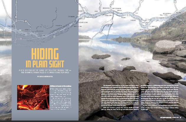
Millions of people who visit and pass through the Gorge each year don’t realize the scope of the cataclysmic stories behind the stunning and tranquil beauty they are surrounded by. The Spring 2019 edition of The Gorge Magazine (page 50) attempts to address that premise with a feature article about the geology of the Columbia River Gorge titled “Hiding in Plain Sight“. The author, Gregg Harrington, who is not a geologist, used a private tour with Lloyd DeKay, president of the Columbia River Gorge Chapter, as well as other local geologists as a basis for much of the article. The article touches on 40 million years of Gorge geology, including the Ice Age Floods, and highlights some of the more interesting geological features of this popular tourist destination. Hopefully, articles like this, along with IAFI field trips, lectures and website, will help many recognize and realize some of the tumultuous story that lies behind the enchanting scenery, and make them “never see the Gorge in the same way again”. The magazine is available online and begins at page 50. We had hoped for an Ice Age Floods Institute website mention, but a planned “For more information” section was not included in the article. Still, the article covers a lot of interesting geology of an extremely popular destination, and an article like this is a significant contribution to our efforts to inform and educate the public about the Ice Age Floods.
Ice Age Floods’ Eye Candy
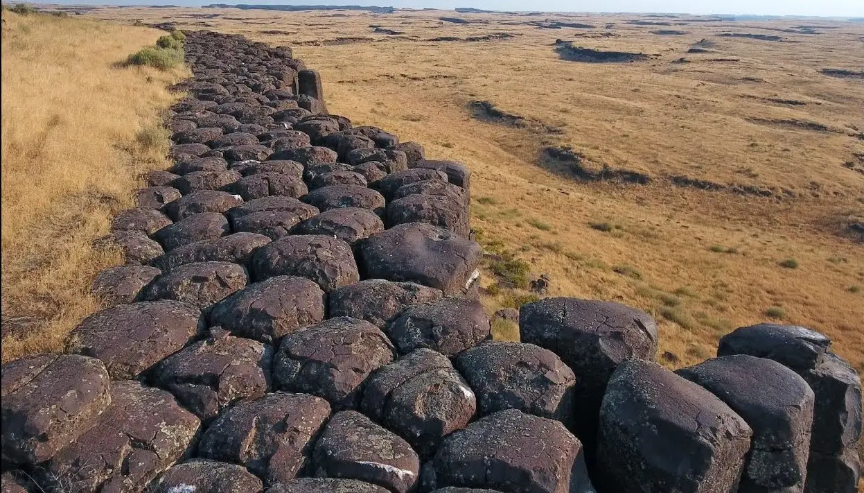
Check out Bruce Bjornstad’s Ice Age Floodscapes YouTube channel. A growing library of surreal aerial video and pics of other-worldly megaflood features.These drone videos and images that can only be achieved and appreiciated from close range in the air give a unique perspective on large landscape features, such as: Gardena Cliffs Rhythmites, Streamlined Palouse Hills, Quincy Lakes Erratic, Moses Coulee, Castle Lake Cataract, Frenchman Coulee, Martin Falls Cataract, Reach Ice Age Floods’ Tours – 2017, Scabland Coulees, Williams Lake Cataract, The Great Blade, Lake Sacajawea Flood Bar, West Bar Giant Current Ripples, Devils Canyon Coulee, Missoula Flood Rhythmites, Ice-Rafted Erratics and Bergmounds, Wallula Gap, Dry Falls, Deep Lake Potholes, and Drumheller Channels
My Hill
As a city kid in the ‘60s my family occasionally visited my grandparents in the farm country of Washington State’s Waterville plateau. My grandfather and two uncles were wheat farmers near the small town of Withrow, the future site of which had been partly hedged in by the Okanagan lobe of the Cordilleran Ice Sheet many thousands of years ago. Sometimes my father and I would join my uncles on the dusty 15-minute drive “out in the hills” to the sagebrush-surrounded corral, well house and large cement watering trough that served the cattle herd pastured there. Overlooking the corral was a tall hill I would sometimes climb while the trough was refilling. Warned to beware of rattlesnakes, a tiring five- or ten-minute ascent would get me to the top. Astride a large boulder, I would survey the corral far below, the sound of the pump engine distantly laboring. Around me was a panorama of other hills, about whose origins it had never occurred to me to wonder. “My hill” was steep enough that even oblong rocks I tossed down its flank would often bounce and roll clear to the bottom. On occasion, this would elicit salty, muffled hollering from Dad to cease and desist. I’m a half-century older, now, but I wish I had then understood the remarkable history of my hill. How would it have felt at that young age to know that a vast ice sheet had blanketed this terrain some 12,000 years earlier and that the hill I stood on had been its progeny? That, as that glacier began to melt, streams and rivulets had formed on its immense surface? That small sinkholes and other weaknesses in the rotting ice had allowed those waters to sculpt caverns inside the glacier? That those waters carried copious quantities of sediment and rock debris captured as the glacier eroded its way hundreds of miles southward? That my hill, like an embryo within an icy womb, had begun to grow inside one of those expanding interior caverns, ultimately to be deposited on solid ground as a kame, a lasting testament to the retreating glacier? Would I have deduced that the glacier had been at least as thick upon the land as my kame was high above the corral below me? That the erratic boulder on which I sat had been deposited on that kame like a cherry atop a geological sundae? I formed an early affection for the Withrow country because of the many relatives who, not so long ago, had peopled that farmland. It’s strange to contemplate that they are mostly gone from this land now, making it seem somewhat alien to me for their absence. And yet that hill remains, a mute sentinel having witnessed the glacier that birthed it, the quiet passage of the millennia, grandpa’s construction of that watering trough in 1948, and the naive delight of a young city kid climbing its flanks in the 1960s. Dan Jordan – IAFI Wenatchee Erratics Chapter
New – Lower Columbia Chapter Brochure
The Lower Columbia Chapter of IAFI recently produced the third IAFI chapter-specific “Our Cataclysmic Floodscapes” brochure, a guide to several of the key Ice Age Floods sites in the Portland Basin. This multi-panel brochure includes brief descriptions and map locations for five key sites, The Story of the Great Floods, Interesting Flood Facts, information about the Lower Columbia Chapter, and more. Expanded out the brochure measures 18″x23″, but it is folded to a rack card size for distribution to visitor centers. Click here to view a PDF of the brochure, and for more information about where a brochure can be obtained please contact Rick Thompson, President of the Lower Columbia Chapter (Rick@GigaFlood.com).
2018 Annual IAFI Field Trip – Lower Columbia Chapter
We started our field trip at the Tualatin library where the bones of a number of ice age mega-fauna are on display. Yvonne Addington led us through the displays and explained some of her role in arranging to have the bones in Tualatin where they were found. After the library we took a stroll on the Tualatin River Greenway Trail where we were instructed by several members of the Rivers of Life Youth Tourism Corp. who volunteered to be docents on the trail. We viewed signs, erratic boulders, casts of the mega-fauna and granite insets with maps and timelines. This $3.8 million trail was put in a couple years ago as part of Tualatin’s ice age identity as well as the $230,000 bronze statue of a young mastodon and a stylized image of the boy who dug it up only about a mile from where the bronze is today. Most of the actual skeleton of the mastodon is now on display in the library. After viewing the statue we went to the neighboring town of West Linn. At Fields Bridge Park we walked the nature trail with its three kiosks revealing the story of the ice age floods and the Willamette Meteorite that landed not far from there when the iceberg it was carried in was grounded on the hillside. From Fields Bridge Park we traveled east on Willamette Falls Drive over the gravel bar that the town of Willamette was built on. We then stopped at the I-205 overlook to see Willamette Falls. This Falls is the second largest in the United States by volume after Niagara Falls. Since this has been a fairly dry year it was easy to see the basalt rocks that the river cascades over. After lunch at Tualatin Community Park we took a short drive to the Tualatin Heritage Center; home of the Tualatin History Society. It is here where the molar and tusk from the Tualatin mastodon is housed as well as a collection of ice rafted boulders from the surrounding area. Yvonne Addington, former president of the Tualatin Historical Society, described the display of news articles, photographs and book covers telling the story of the Center and the ice age features. Our next stop, the Tualatin Commons, has a man-made lake with undulating hand-railing representing the wave action of the Ice Age floods and glass drinking fountains representing icebergs in those floods along with several ice rafted boulders; one being an argillite. Partly for fun and partly to see how a community can capitalize on an ice age idea we went to Ibach Park with its symbolic ice age floods play structures. The spongy blue pavement represented the water; some of it including ripples with icebergs. In the sand area children can dig for replica fossils and with the water feature they are able to make their own ice age floods through a collection of ice rafted erratics. We viewed the sign that for the last 20 years has been telling people about the ice age floods, the Willamette Meteorite, the mastodon and the local history. This award-winning park and its structures and signage was years ahead of other areas in adopting the ice age floods theme. Click here to view the full article with many more pictures. Between the towns of Tualatin and Sherwood there is a series of ice age flood channels that funneled the water from the Tualatin Valley into the Willamette Valley. This area is called the Tonquin Scablands. We stopped to view an erosional remnant of two basalt flows separated by a soil horizon and Coffee Lake, a kolk lake, created when two flood channels converged and formed a vortex that removed rock and soil leaving what is now a coffee-colored lake. We then drove along the largest of the 14 Tonquin Flood Channels to an area where we could get out and view that channel both north and south.
Ice Age Features in Shallow Waters
Many of the features left behind by the ice age floods are not apparent to the average visitor to areas where the floods were relatively shallow, such as the Bitterroot River valley south of Missoula, Montana. The Bitterroot Valley has erratics and subtle strandlines in several locations. J.T. Pardee, the Montana geologist who in the early 1900’s identified the source of the water for Bretz’s flood, published a paper and sketches specifically about the Bitterroot valley, where he was living at the time. These features can be used to tell the Ice Age Floods story if put together in a useable format. That is just what happened this summer when Jessica Dufresne, a local elementary school librarian, was selected to develop a curriculum aimed at 4th-8th grades under the National Park Service’s Teacher Ranger Teacher program. The program is aimed at linking to lesser known park units such as the Ice Age Floods National Geographic Trail to underserved student populations and offers professionals the opportunity to learn about the resources and educational materials available through the National Park Service. Dufresne, daughter of Glacial Lake Missoula chapter vice president Lynne Dickman, grew up with geology and always found it interesting. Now she can share that enthusiasm with other teachers and young learners. Other partners in the grant were the Montana Natural History Center and the Bitterroot Cultural Heritage trust. The Glacial Lake Missoula chapter also assisted in locating these features and plans to add them to its field trips and its map and guide.
Boulderstrewn – Bretz’s Historical Home
“Boulderstrewn” is the home J Harlen Bretz built in the Chicago suburbs in the 1920’s and died in on his 98th birthday. Much of Bretz is still there, and since purchasing Boulderstrewn over 10 years ago the current owner has toiled to resurrect Bretz’s presence on the property. The owner created a rock garden of many specimens that remain on the property, which had been slowly getting buried. Many monuments Bretz built are still there – a travertine bird bath, a sandstone sundial and a concretion on a pedestal. Inside the house, besides an updated kitchen, it’s very much the same as during the time of Bretz and Fanny. The basement features Bretz’s still usable cold shower (no hot water just as Bretz liked it) and soap dish (though someone painted the shower white). Bretz’ secret wine cellar room is also still there, though the gate and intricate lock system is gone. Little remnants of his boobytraps are everywhere, as well as old bottles from his winemaking days and a few license plates. The Garden Cabin with a beautiful stone fireplace he built in the back of the yard for Fanny to do her art is still there, recently fully restored and rescued from sinking into the ground. As you can see in the photos on the AirBnB site the property appears to be in impeccable shape. The current owner, Peter Doran, no longer lives in the area and is unable to continue supporting the house expenses. So he is considering options from AirBnB to selling the property, and is receptive to interest and other suggestions. If anyone has, or knows of someone who has an interest in or ideas for preserving this bit of Bretz’s historical legacy please get in touch with him at peter.t.doran@gmail.com.