Explore the Ice Age Floods with 12 New IAFI Brochures

IAFI has compiled 12 brand-new, full-color brochures into a packaged set to help guide you in visiting spectacular ice-age features across all of our 11 Ice Age Floods chapter areas. With these brochures as your guides you can explore the paths of the Ice Age Floods from Montana through Idaho, central Washington and northern Oregon, and even delve into the many glacial features of northwest Washington. Click on any of the brochure covers below to see a full size printable PDF version (note: you’ll need to scale down to print on 8.5×11 letter size paper). Packets of all 12 full-size brochures are NOW available through the IAFI Store and at participating local outlets. Click a cover to open a PDF of any of the brochures below
Become An Ice Age Floods Junior Ranger
The National Park Service has developed a new Junior Ranger Program for the Ice Age Floods National Geologic Trail. They’ve developed a Megaflood Adventure Junior Ranger Activity Book in three separate section to help guide Junior Rangers in seeing what they can find as they explore the area of the Ice Age Floods.They will be working on a reduced size version that will be fillable online, but for now the three sections that form the complete book must be downloaded and printed: Megaflood Adventure section 1 Megaflood Adventure section 2 Megaflood Adventure section 3 To receive the Junior Ranger badge when the three sections are complete, mail the booklet to: Ice Age Floods Junior Ranger 1008 Crest Drive Coulee Dam, WA 99116 They will be adding more in-person sites as the program grows. They would also love to receive feedback! Please send an email to let us know what you liked, what worked well for you, and ways that the program can be improved.
Ice Age Floods Playscape in Spokane Riverfront Park
By late summer or early fall of 2020, Riverfront Park will have an interactive playground that will be almost an acre in size. The great ice age floods that shaped the Inland Northwest also are shaping the new playground on the North Bank of Riverfront Park. The playground’s theme is Ice Age Floods, which will allow kids to both play and learn about Spokane’s history at the same time. Designers thought to add this theme since the Ice Age Floods had a significant impact on Spokane’s geology. “That parcel has always felt like an outlier,” says Dell Hatch, a landscape architect and principal in charge of the North Bank project for Bernardo|Wills Architects (BWA), “so it’s really cool to integrate that north side as another element of the park. Kids are going to be able to discover as they play, in the sand areas and as water moves through the playground, They’re going to be learning without even knowing they’re learning.” Soon the space will be home to a wheels park for skateboards, inline skates and scooters, new Hoopfest courts, parking served by improved access off Washington Street, and a new operations building to serve the park’s back-of-house needs. The North Bank will also connect with the soon-to-be-built Sportsplex, located on the basalt bluff above. But the centerpiece will be a 1-acre-plus destination playground themed around the Ice Age Floods that carved out the Spokane River Gorge some 15,000 years ago. “You are going to see some water play features, you’ll see some geology features too, some rocks in different elements the kids can climb around as they learn what the geology of eastern Washington is and why it is so special to our region,” said Fianna Dickson with Spokane Parks and Recreation. Some playground features will help children learn about nature and geology, like a stream that teaches about currents and damming. A climbing wall, rope suspension bridge, large rocks that children can climb, a splash pad, and a 30-foot tall climbing tower with tube slides, would be play elements in the park. “We’re working with Nigel Davies [a geologist from EWU], and we’ve held a workshop with the Ice Age Floods Institute,” says Bill LaRue, a landscape architect with BWA and project manager for the North Bank. “We’re working in like five or six different types of basalt, fossils of local flora and fauna — even a petrified forest.”
IAFI Board Begins Strategic Plan Update
Strategy has many definitions, but generally involves setting strategic goals, determining actions to achieve the goals, and mobilizing resources to execute the actions. Strategy can be planned or can be observed as a pattern of activity as the organization adapts to its environment or competes. A strategic plan defines an organization’s priorities, directions and resource allocations to guide its decision making, and it’s useful for guiding and informing an organization’s teams and other, as well as for documenting progress. The last time IAFI updated its strategic plan was in 2011, so the board of directors a initiated a thorough review at their recent Sept meeting. While the basic priority areas remain unchanged (Membership Services, Education and Outreach, Trail Advocacy, Finance and Administration), many of the previous goals and strategies have been met or are outdated. Teams were assigned to review and develop new goals and strategies for each of the priority areas. The whole board will then prioritize, choose, and allocate resources for the goals IAFI will focus on for the next few years. Expect to hear more about this process in coming months.
Model for a Missoula Flood
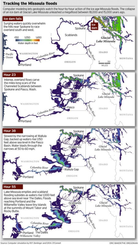
ICYMI (in case you missed it) — Floodwaters rise more than 1,000 feet as they slam into the Columbia River Gorge from the east. The torrent blasts through the narrows at 60 mph, carrying truck-size boulders and house-size icebergs. Reaching Portland, water loaded with gravel and dirt roils to a depth of 400 feet, leaving tiny islands at the summits of Mount Tabor and Rocky Butte. Geologists have spent decades piecing together evidence to tell the story of the great Missoula floods that reshaped much of Oregon and Washington between 18,000 and 15,000 years ago. Now scientists have found a way to travel back in time to watch the megafloods unfold, in a virtual bird’s eye view. Their computer simulation displays the likely timing and play-by-play action, starting with the collapse of an ice dam and outpouring of a lake 200 miles across and 2,100 feet deep. The computer model, developed by Roger Denlinger with the U.S. Geological Survey in Vancouver and Colorado-based geophysicist Daniel O’Connell, is filling gaps in scientific explanations of the floods and the baffling landforms they left, including the fabled Channeled Scablands — scars hundreds of miles long cut into the bedrock of eastern Washington and visible from outer space. The simulations also may help settle a lingering scientific controversy about what caused the repeating ice-age catastrophes. “It’s just really powerful visualization that gives a sense of the scale of the floods, how they came down through the channel system and backed up the big tributary valleys,” said Jim O’Connor, a hydrologist with the U.S. Geological Survey in Portland who has written extensively on the Missoula floods. He said the modeling work provides the first “really good information” on the timing of events. During the last ice age, a continent-spanning ice sheet built from massively expanded glaciers descended from the Canadian Rocky Mountains to reach deep into Washington, Idaho and Montana. Glacial Lake Missoula formed behind a miles-long dam of ice across what is now the valley of the Clark Fork and Pend Oreille rivers running from Montana to northeast Washington. The dam formed and collapsed dozens of times over a span of three thousand years. In the simulation of one of the largest possible floods, raging water quickly overwhelms the hills near Spokane and races overland to the south and west. The intense, overland flows carve the miles-long scars of the scablands between Spokane and Pasco, Wash. Thirty-eight hours later, swirling, mud-darkened waters converge at the narrowing of the Columbia at Wallula Gap, where the backed-up flow rises 850 feet above river level (1,150 feet above sea level). An immense volume of water blasts through the narrows at fire-hose velocity. Flow exceeds 1.3 billion gallons per second — a thousand times greater than the Columbia’s average flows today. Lake Missoula’s water, all 550 cubic miles of it, drains in 55 hours — less than three days — according to the model. At that time, the flood surge peaks in the Columbia Gorge at The Dalles, rising 950 feet above river level (1,000 feet above sea level), spilling over the gorge walls in places, and flooding the valleys of tributaries for miles upstream. Inundation of the Willamette Valley peaks on the seventh day after dam burst, in the simulation. Flooding reaches as far south as Eugene. Loaded with mud and gravel, the flood dumps sediment across the entire valley. Repeated floods build a layer 100 feet thick in Woodburn. Such a vast inundation, far greater than anything ever witnessed in historical time, seemed impossible to geologists in the 1920s, when J Harlen Bretz proposed that the scablands resulted from a catastrophic flood, not eons of gradual erosion. The idea didn’t gain mainstream acceptance until the 1960s. Since then, geologists have found evidence that Lake Missoula emptied catastrophically dozens of times during the last ice age. But controversy persists. A few scientists assert that the cataclysmic floods must have had multiple sources, not just an outburst from Lake Missoula. John Shaw of the University of Alberta in Edmonton, for instance, has proposed that an enormous reservoir beneath the ice sheet over much of central British Columbia boosted the flooding. The new simulation suggests that discharge from Lake Missoula alone would have been powerful enough. The simulated flood reaches peak stages all along its route that match the evidence visible today in sediment, with one big exception: At Wallula Gap, water levels in the simulation fell short by as much as 130 feet. “It’s pretty clear, if Lake Missoula is enough to hit all the other high water marks, you don’t need another source of water,” Denlinger said. Calculating the convoluted paths of such a massive flood requires an immense amount of number crunching. Simulating one flood requires more than 8 months of computer time, Denlinger said. But the computer simulation isn’t likely to end the debate. The fact that it can’t reproduce the maximum flooding at Wallula Gap leaves room for doubts. And some experts say there is direct evidence for an additional source of flood waters from beneath the ice sheet that covered the Okanagan Valley. “It is conceivable that other valleys in southern British Columbia contributed water to the scablands but the field evidence necessary to test these possibilities has not been fully documented,” said earth scientist Jerome-Etienne Lesemann at the University of Aarhus in Denmark. “There are a number of unanswered questions,” he said. “That makes the whole Channeled Scablands story a really interesting and intriguing geological puzzle.” Reprinted from The Oregonian, original article by Joe Rojas-Burke, 2010
11+1 New Ice Age Floods Chapter Brochures
Individualized brochures for each of the eleven IAFI chapters highlighting several local Floods features have been an Ice Age Floods Institute dream for the past several years, and we’re finally awakening from that dream. It began when the Lake Lewis Chapter produced a stunningly beautiful and informative 18″x24″, 24-panel, 6-fold brochure several years ago that highlighted five “Must See” Floodscapes in the south-central Columbia River Basin. Chapter representatives on the IAFI Board were so taken with the brochure that they all agreed each chapter should produce a similar brochure for their area. Unfortunately a major fly in the ointment was that no other chapter had the professional expertise to do the job. Rick Thompson of the Lower Columbia Chapter poured many frustrating hours over a couple of years into producing a similar brochure for his chapter. He eventually found an incredibly helpful resource in Ken Manske (NorthwestArtMall.com) who compiled Rick’s opus into printable form and got it printed. So now there were two brochures, but at such an expense in time, frustration, and cost that most other chapters were unable or unwilling to take on the task. Fortunately, Lloyd DeKay of the Columbia River Gorge Chapter was willing (or crazy enough) to take on the overall project under the guidance of Ken Manske (northwestArtMall.com). Ken offered a critical suggestion to change the format to a 12″x18″, 6-panel, industry-standard tri-fold design that would cost 60% less to print. Based on that suggestion, since last October Lloyd has used Inkscape, an open-source Adobe Illustrator-like program, with input from Ken and each chapter’s representatives, to design and compile new brochures in that format for the Columbia River Gorge, Puget Lobe, Wenatchee Valley Erratics, Glacial Lake Missoula, Palouse Falls, Cheney-Spokane, Coeur du Deluge, Ellensburg chapters and redesign the Lake Lewis and Lower Columbia brochures in the same format. Work is nearly complete on the final Lower Grand Coulee brochure. Because stocks of the general IAFInstitute 9″x12″ tri-fold were running low, that brochure has also been redesigned and printed. All 12 brochures are available individually and as a complete set. We can all learn from this exciting set of new brochures, each highlighting five or more local features, to help guide members, their visitors, and tourists in exploring the fascinating story of the Ice Age Floods all along and beyond the Ice Age Floods National Geologic Trail.
PacNW Geology Videos – Nick Zentner

Do you want to learn about the fascinating general geology of the Pacific Northwest? Well, perhaps the easiest and one of the most ways to do that is to watch some of the many videos Nick Zentner and his film crews have made and posted on YouTube. Nick has been the host of a dizzying number of short (2 Minute Geology) to long (1+ hour free public lecture) videos covering everything PacNW geologic from 40+ million year old continental accretion to ice-age floods, flood basalts to our awesome volcanoes, huge landslides, and even earthquakes yet to happen. Nick is an award-winning professor of geology at Central Washington University in Ellensburg, WA. His is an ongoing crusade to bring the drama of Northwest geology to life for everyone – not just academics and die-hard rock hounds. Pacing and narrating with gee-whiz enthusiasm, Nick combines simplicity and scientific rigor, presenting his subject matter in a way that’s stimulating, fun and educational to students and the general public. Here are links to some of his YouTube channels and the topics you’ll find there: Huge Floods Channel – 2-Minute Geology Series – 13 videos including: Geology Video Blooper – Columnar Basalt – 0:54 Columnar Basalt – Geologist explains spectacular stone columns – 2:31 What is a Coulee? 2:36 Erratic Boulders – Rafted in Icebergs by the Ice Age Floods – 2:37 Giant Current Ripples Created by the Ice Age Floods – 2:51 Pillow Basalt (Lavas) and Palagonite. Result of lava flowing into water – 2:52 Columbia River Basalt Group – Related to Cascade Volcanoes? 2:59 The White Bluffs at Hanford Reach – Columbia River Free Flowing Stretch – 3:00 What is a meander – Geologist describes meandering streams, rivers and oxbow lakes – 3:02 Petrified Wood – 15 million-year-old Petrified Tree – 3:31 Seattle Earthquake Fault – Beneath Largest City in the Pacific Northwest 3:42 Wenatchee Washington – Ice Age Floods Geology – 4:34 Palouse Falls and the Palouse River Canyon – Ice Age Floods Features – 5:12 Nick Zentner Channel – Roadside Geology Series – 7 videos including: Frenchman Coulee: Central Rocks – Roadside Geology #1 – 10:48 Vantage Erratics: Central Rocks – Roadside Geology #2 – 11:55 Yakima River Rocks: Central Rocks – Roadside Geology #3 – 10:36 Yakima River Canyon: Central Rocks – Roadside Geology #4 – 11:55 Thorp Moraine: Central Rocks – Roadside Geology #5 – 8:38 Thorp Lahars: Central Rocks – Roadside Geology #6 – 9:37 Dry Falls: Central Rocks – Roadside Geology #7 – 9:50 Nick On The Rocks – 18 videos, including: Seattle Fault – 4:01 Yakima River Canyon – 4:16 Lake Chelan — Battle of the Ice Sheets – 4:24 Puget Sound’s Exotic Terranes – 4:25 Dry Falls – 4:37 Chasing Ancient Rivers – 4:42 Ice Age Mystery of Lake Lewis – 4:42 Bridge of the Gods Landslide – 4:44 Steamboat in the Desert – 4:50 Mt Rainier’s Osceola MudFlow – 4:51 Ghost Forests – 4:54 Ancient Cascades Volcanoes – 5:01 Columns of Basalt Lava – 5:01 Giant Lava Flows – 5:06 Liberty Gold Mines – 5:07 Mount Stuart – From Mexico? – 5:11 Giant Ripples in the Scablands – 5:11 Goldilocks Miracle of the Palouse – 5:20 Downtown Geology Lectures – CWU Geology Series – 14 videos, including: Supercontinents and the Pacific Northwest – 56:33 Ancient Rivers of the Pacific Northwest – 57:17 Liberty Gold and the Yellowstone Hotspot – 58:05 Tsunami In Our Future – 59:09 “Bing Crosby, the Sunset Highway and the Channeled Scablands” – 1:01:24 Flood Basalts of the Pacific Northwest – 1:02:35 Great Earthquakes of the Pacific Northwest – 1:04:01 Hells Canyon and the Ringold Formation – 1:04:35 Bridge of the Gods Landslide – 1:05:22 Mount Rainier’s Osceola Mudflow – 1:05:52 Lake Chelan Geology – 1:07:18 Exotic Terranes of the Pacific Northwest – 1:09:23 Floods of Lava and Water – 1:10:18 Supervolcanoes in the Pacific Northwest – 1:10:50 Ghost Volcanoes in the Cascades – 1:11:15 Plant Fossils in the Pacific Northwest – 1:13:17 Dating the Ice Age Floods – 1:26:23 TEDxYakimaSalon | Nick Zentner Sharing Geology
Grand Coulee Dam Story
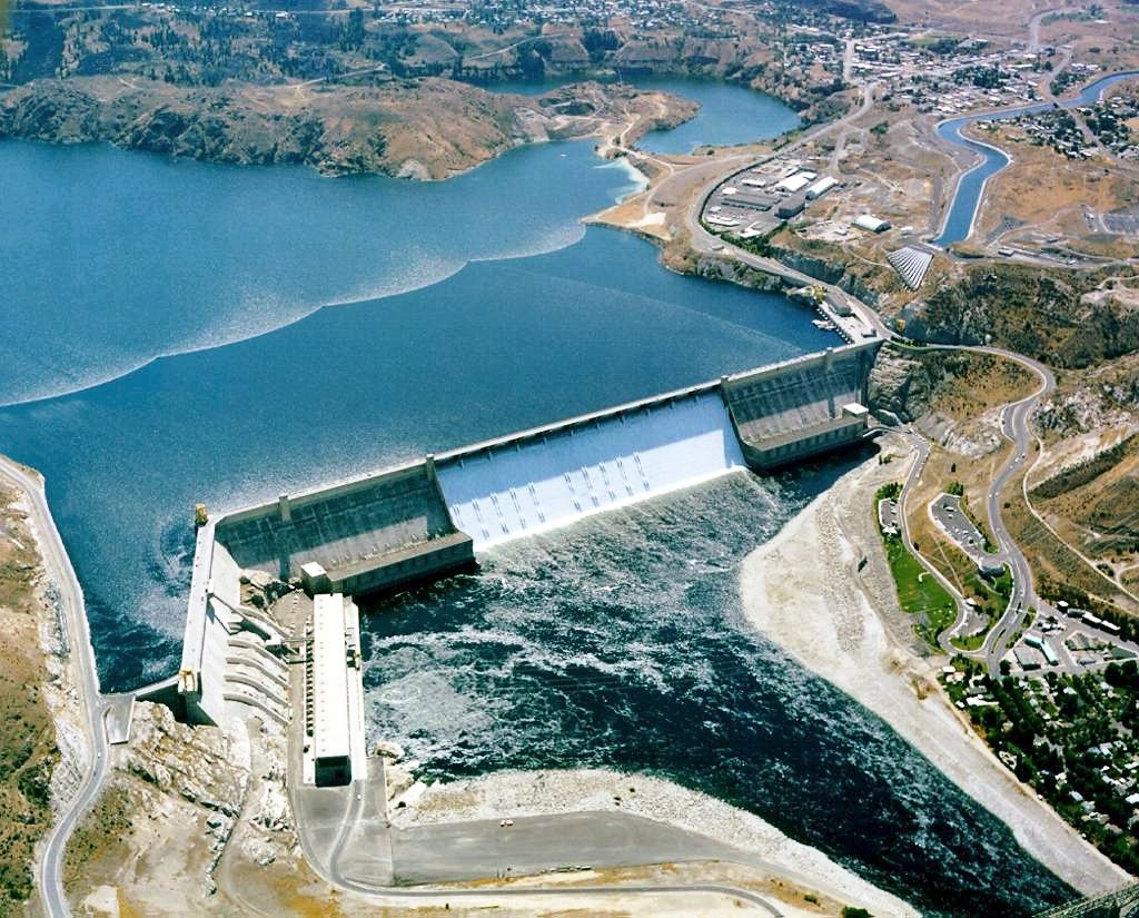
1918 story in the Wenatchee World that Bill Dietrich (former Columbian reporter and later with The Seattle Times) says in his wonderful 1995 book Northwest Passage — The Great Columbia River , “is probably the single most famous newspaper article in Pacific Northwest history. . . It is generally credited for launching the long debate about Grand Coulee Dam.” Students, fans and the mildly curious about any or all of: Grand Coulee Dam, The Columbia River, the massive Columbia Basin irrigation project, Eastern Washington in general, Washington state history, will find this article interesting.
Oral/Pictorial Video History of the Palouse Area
This 1/2-hour video begins with the Ice Age Floods impact on the Palouse area, then goes on with a fascinating oral and pictorial history of the area. The video was produced by Mortimore Productions for the Whitman County Library with materials and information provided by a bevy of contributors, including several IAFI members. This is a must view if you’re planning to travel to the Palouse Falls Chapter. In this stunning video you’ll learn about the Floods impact, early settlers, mule trains, sheep herders, and so much more that will make the event ever more personal and relevant. Whitman County Library – Ice Age v06 from Mortimore Productions on Vimeo.
Why pay dues to IAFI????
Membership in IAFI did not grow last year, and more than a couple of local program participants I know do not belong. They may have personal reasons for this decision, but I decided to look at the cost/benefit for myself (disclaimer – I am not a board member). Most of the revenue of the Ice Age Floods Institute is from dues – dues that it shares 50-50 with member chapters, leaving it with a very modest $13,000 to spend. The rest of the budget is made up from a few donations (under $1000), income from sales from the store ($1500), field trips ($800), and income that is offset by expenses (such as brochures). This is not a large budget to work with. Some of the budget goes to contracted staff services, some is paid out for costs related to board meetings, and the rest goes to operating costs such as insurance and banking services. Some vital services – such as the website – are largely provided by volunteer effort. So what is the benefit of paying dues? While you do get a break on anything purchased from the IAFI bookstore, and on the cost of some field trips, many of the benefits of joining a mission driven organization are more intangible. The benefits include the continued existence of an organization to accomplish goals that you feel are important, helping you, the member, direct your volunteer activities in a way that promotes those goals; by providing a mechanism to receive grants and donations to carry out these activities; and by guiding others in a way that gets things done that couldn’t be finished by a few people working alone. The achievements of the organization as a whole are impressive – look at the “year in review” in the January 2019 Newsletter. The list includes lectures and field trips open to the public, brochures and educational materials, visits to classrooms and community organizations, the website, the newsletter, and partnerships and collaboration with related organizations. These activities are carried out primarily by local chapters and members on a volunteer basis – so a volunteer might feel his/her time is enough of a contribution, and actual membership and dues are not needed. While valuable – even critical – these activities should achieve more when carried out in a framework provided by the central organization. So when deciding whether to send in that annual check, you need to evaluate not what monetary benefits you might receive but whether your goals align with those of the central organization and whether the central organization is effective in achieving those goals. If so, get out your checkbook/credit card/cash and give generously. If not, let your board members know what should be changed to gain your support. Sherry McLaughlin – Glacial Lake Missoula Chapter