IAFI Covid-Focus: On-line Meetings and Presentations
On June 20th the IAFI Board of Directors had an on-line meeting to plan our activities for the remainder of this year. With the Covid-19 infection rate increasing in many areas because of the easing of restrictions, it seems prudent to focus most of our activities on on-line meetings and presentations. This way we continue to provide educational programs while protecting the health of our members. Several chapters are taking different approaches to maintain some degree of member activities during this period, including: Conducting Zoom meetings for chapter members Conducting Zoom presentations by invited speakers for chapter members and the general public Leading “car caravan” field trips Recording and sharing “virtual” field trips Emailing ‘Photo of the Week’ to chapter members Partnering with other institutions and groups for educational programs Installing signs and markers and sharing news announcements with members Highway clean-up as a chapter activity while maintaining social distancing Watch for notices from chapters and on this website as events are scheduled. We look forward to the time we can resume more in-person activities.
Nick Zentner – More Geology Videos

Are you looking for new geology videos? Nick Zentner has done a long series live geology lectures from his home in Ellensburg and posted them online to his YouTube channel https://www.youtube.com/user/GeologyNick/videos He is now recording a series of “Nick on the Fly” virtual field trips and posting them on the same YouTube channel https://www.youtube.com/user/GeologyNick/videos Join Nick as he explores the geology of the Pacific NW and many other topics.
Trashcano, Geologists Just Wanna Have Fun
Geologist, Dr. Chad Pritchard, explores the gas expansion phenomenon that powered the May 18, 1980 Mt. St. Helens plinian eruption. Of course, not everyone has a supply of liquid nitrogen to experiment with — and that’s probably a good thing. Enjoy!
Resources for Kids Learning Science at Home
Do you have kids at home and you’re looking for educational resources for learning about science? Washington Geological Survey has tons of cool information about Washington’s geology to read about! Check out these pages!
DECIPHERING THE CHANNELED SCABLANDS FIELD WORK CONTINUES
In August, Scott David, a postdoctoral researcher and Karin Lehnigk, a 2nd year PhD candidate from the University of Massachusetts visited the scablands for a week to do field studies. Karin was in search of granite erratics. Samples of these were taken to be processed for Beryllium-10 exposure dating, a robust geochemical technique which enables researchers to determine how long the object sampled has been sitting on the surface of the Earth. This information combined with computer simulations of a range of flood sizes is to test the hypothesis that the earliest floods through the Cheney-Palouse Scabland Tract were also the largest. Scott was in search of potholes. Measuring the geometry of potholes and the rocks that comprise them in a variety of locations, he is using these measurements in numerical and physical modeling experiments to explore what erosion mechanisms could generate these massive features. Were they produced by retreating waterfalls, rocks circulating at the base of the flow, large scale turbulence, or some combination of these mechanisms? The results of the study should provide insight into how the remarkable canyons that comprise the Channeled Scablands formed. On a Friday afternoon, I met up with them in Ritzville and proceeded to some granite erratics near Cow Creek southeast of town to take samples. They spent the night at our house in Washtucna and were thrilled to have hot showers, a home-cooked meal and soft beds. The days before they slept in tents on a gravel parking lot. The next morning, Chad Pritchard from EWU joined us as we took measurements from four pot-holes along the south side of Washtucna Coulee between Washtucna and Hooper. They also took granite samples from the Midcanyon Bar near Lyons Ferry before returning to the Grand Coulee area. The results of their studies were not available at time of printing. Article by Lloyd Stoess in The Scablander
‘Nick From Home’ geology livestreams continue
‘Nick From Home’ geology livestreams continue…5 new videos per week. Join us live! https://www.youtube.com/user/GeologyNick/featured Geology lessons for students of all ages. Watch replays below. 6:00 pm on Tuesdays, Wednesdays, & Thursdays 10:00 am on Saturdays & Sundays #15 Bridge of the Gods Sunday, April 5 @ 10:00 am #14 Great Earthquakes Saturday, April 4 @ 10:00 am #13 Ghost Volcanoes https://youtu.be/Lk57el9Exs0 #12 Cascade Volcanoes https://youtu.be/vdqFgV-NLbY #11 Olympic Peninsula https://youtu.be/sFw3h8OROLU #10 Baja BC Exotic Terranes https://youtu.be/b-td-r-8ByI #9 Supercontinents https://youtu.be/59lzPcDeSWc #8 Liberty Gold w/ Rob Repin https://youtu.be/XV82f_cdcPc #7 Ginkgo Petrified Forest https://youtu.be/jWhlMLFXW2I #6 Flood Basalts https://youtu.be/RH6N93j_D-o #5 Ellensburg Blue Agates https://youtu.be/dmPtgFsYvpA #4 Ancient Rivers https://youtu.be/nFG_WOnF58U #3 Ice Age Floods https://youtu.be/o9ZaLLGAxO8 #2 Earthquakes https://youtu.be/UJ7YsbGjJG0 #1 Volcanoes https://youtu.be/UnXNXtwuG3Y
Use Social Distancing Time to Explore the Floods with Our Interactive Online Map
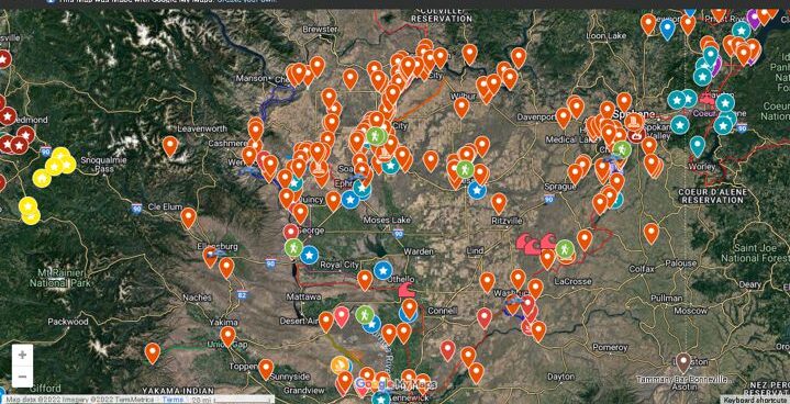
If you’ve ever tried to explore the Ice-Age Floods with a guidebook you’ll know how difficult and frustrating it can be to find and learn about the features in the area you’re visiting. Well, there’s now a solution to that problem; an interactive map that’s available wherever you have internet access. The map features over 300 points of interest throughout our 4-state area, with a description and images that slide out when you click on one of the markers. More features are being added all the time, and we’re planning to expand the map with features related to the Lake Bonneville Flood event that rampaged through the area during the time of the Ice-Age Floods. Since this is an internet-based map, it’s also easy to get driving directions to the site from wherever you are starting from. You can also easily build an informative field trip, exploring and learning about a number of other nearby features with just a few clicks of your mouse. We feel this may be the most useful field guide ever developed to explore ice-age Floods and glacial features throughout our 4-state region. AND it’s absolutely FREE! The only shortcomings we see are 1) the map requires internet access, which isn’t always available in far-flung areas of our region, and 2) we may not have every point-of-interest on the map (YET!). If we’re missing something you think is important we encourage you to submit your suggestion. We also appreciate any comments and/or corrections by email to Webmaster@IAFI.org. We sincerely hope you enjoy using this guide to poke around these fascinating ice-age features.
RIP – Tom Foster, Remarkable IAF Chronicler
We very sadly report that Tom Foster passed away recently of an apparent heart attack while home sleeping with a chest cold. Tom was a talented photographer and videographer who worked tirelessly behind the cameras with our own Nick Zentner to bring PacNW geology and the story of the Ice Age Floods to life through photographs and videos. His HugeFloods.com website was also a rich resource for images and information about the Ice Age Floods. His obituary has more details about this remarkable man: Thomas Alan Foster, 60, with his love for the outdoors, died at his home in Pasco, WA March 4. Tom took great pleasure photographing beautiful Northwest scenery including Ice Age Flood features. He learned the art from his father John P Foster, professor emeritus at Central Washington University. Tom was born September 18, 1959 in Roswell, NM to John and his wife Barb. His family was proud when he achieved the rank of Eagle Scout. A graduate of Ellensburg High School, he took classes at CWU and Edmonds Community College. Tom will be sorely missed by all who gained understanding and pleasure from the work behind the camera that he shared with us all.
IAFI – 2019 Year in Review
2019 Year-End Report (January 9, 2020) 25 Years/10 Years – For twenty-five years we have been enjoying helping people of all ages and backgrounds learn about the ice age floods. For the last ten years we have also been helping people learn about the Ice Age Floods National Geologic Trail. Our annual plan of work varies somewhat from chapter to chapter and from year to year. Listed below is a summary of some of our major Institute activities during 2019. Institute Membership – Our members provide most of our support and much of the reason for the various materials, activities and events we provide. In 1996, we had 11 members. At the end of 2019, we had 723 members (501 memberships) from 15 states and 1 Canadian province. Some of our members have supported us for many years. We thank all of you for your continued support. Programs for our members and other people interested in the floods – Outreach to inform and educate the public about the Ice Age Floods and their long-lasting impact on our area is a key part of the IAFI mission. Our local chapter programs are possibly the most effective way we meet this challenge. Two of the more important ways we help people learn about the Ice Age Floods are with lectures and field trips. In 2019, we sponsored 50 Lectures attended by 2327 people. We sponsored 17 Field Trips with 515 attendees. We also had 12 hikes for 142 attendees. We have also significantly increased our online outreach, typically garnering thousands of views each week of interesting articles and features through our Facebook, website and newsletters. Participation in Community Events – Participation in community events is another great way to share our message and draw new interest to the Ice Age Floods and our organization. Again in 2019, our chapters participated with presentations and display booths at a great many community events throughout our four-state floods area. Some examples include: booths at community fairs, lectures and field trips at the Othello Sandhill Crane Festival, Cheney-Mayfest, Earth Day celebrations, Clark Fork Days, Boy Scouts of America meetings, the Maryhill Museum, and many others. Working with schools (K-12 and higher education) – Bringing the floods’ stories to students may be the most important way we can capture the interest and involvement of new generations. Some of our activities in 2019 are listed below. Wenatchee chapter worked with 300 elementary students thru the Wenatchee Valley Museum and Cultural Center The Coeur du Deluge Chapter distributed copies of their new ice age floods map to schools in the Sandpoint area. Lake Lewis Chapter worked with the Kennewick School District’s Community Education Program. Also worked with the WSU Tri-cities program. Puget Lobe Chapter did outreach for Tahoma School District: integrating floods curriculum into 10th grade science. Glacial Lake Missoula Chapter: worked with Meadow Hill Jr. High – combined science media and art project. A movie, a program and new floods original artwork for gym. New educational materials – To help people learn about the floods we are continually developing new ways of communicating information to people. Here are some examples from 2019. All of our chapters now have new high quality brochures with highlighted floods features in their area. We also have an updated IAFI brochure. The Institute is continuing work on our Floods Features on-line exploration map. Bruce Bjornstad has submitted his new coffee-table sized book entitled: Ice Age Floodscapes of the Pacific Northwest: A Visual Portrait to his publisher (Springer-Nature). It consists of about 180 pages of world-class photographs of ice-age floods features from throughout the floods area. It will be an instant classic and we are anxiously waiting its release. We will let you know about this with a post on our website as soon as it is available. Nick Zentner from Central Washington University continues to delight and inform us about the geology of Washington with his internet series Nick on the Rocks. Wenatchee – is working on a new display for Butte and Basin topography on Babcock bench. Coeur du Deluge – released a two-sided geologic map in honor of Roy Breckenridge. Side One: Glacial Geologic Map of North Idaho and Side Two: Shaded Relief map of northern Idaho and parts of western Montana and eastern Washington. Lake Lewis – three new floodscape videos by Bruce Bjornstad have been posted on YouTube. The chapter is assisting with interpretive signs for Candy Mountain. Cheney-Spokane – installed interpretive signs for Ice Age Floods playground, Riverfront Park, Spokane, WA Columbia River Gorge – developed 1 new IAFI Brochure and 11 new IAFI chapter brochures, and a major update to an interactive floodscapes exploration map on the website Glacial Lake Missoula – developed a summary video for a new display that illustrates the filling, dam failure and draining of Glacial Lake Missoula. Detailed videos are synched to lesson plans teachers can use in the classroom. Partnerships and collaboration with other organizations – We are always looking for other organizations to work with. This is a great way to share resources and knowledge. Here are some of the organizations we worked with in 2019. We thank them for sharing our interest in the Ice Age Floods. Wenatchee – Wenatchee Valley Museum and Cultural Center, Port of Quincy (Babcock Bench), Othello Sandhill Crane Festival Coeur Du Deluge – Idaho Master Naturalist Program Lake Lewis– Friends of Badger Mountain, Benton County Parks, The Hanford Reach Interpretative Center, Visit Tri-Cities, East Benton County Historical Museum, Franklin County Historical Museum Cheney-Spokane – Spokane Riverfront Park board, Ice Age Floods Playground Palouse Falls – Whitman County Library, Lower Columbia Libraries, Lacrosse Community Pride Lower Columbia – Tualatin Heritage Center, City of Tualatin, Tualatin Chamber of Commerce, Tualatin Ice Age Foundation, Friends of Vista House Columbia River Gorge – Oregon Master Naturalist Program, Columbia Gorge Discovery Center Glacial Lake Missoula – Montana Natural History Center Lower Grand Coulee – Coulee Corridor Consortium- Coulee Corridor National Scenic Byway; Coulee Corridor Area State Parks; Columbia Basin Trails Association Promoting Tourism
New Release – Glacial Geology Maps of North Idaho

IAFI Store is proud to offer a new, two-sided Glacial Geology of North Idaho map that includes a GLACIAL GEOLOGIC MAP OF NORTH IDAHO on one side and a SHADED RELIEF MAP OF NORTHERN IDAHO AND PARTS OF WESTERN MONTANA AND EASTERN WASHINGTON on the other side.The maps are 33.75” x 21.5” in size and are available as both flat and folded versions at a price of $9.95 + tax and shipping. The GLACIAL GEOLOGIC MAP OF NORTH IDAHO is a color map produced at the scale of approximately 1/175,000 that represents over 30 years of research and field work by Dr. Roy Breckenridge, former Idaho State Geologist and VP of the IAFI Coeur du Deluge Chapter. The second author of this map was Dean Garwood who, following Roy’s passing, organized Roy’s information and used his GIS skills to put together multiple information layers to produce the final map. The map is in commemoration of Roy and his dedication to the fields of geology and education and his commitment to our chapter and the Ice Age Floods Institute. The SHADED RELIEF MAP OF NORTHERN IDAHO AND PARTS OF WESTERN MONTANA AND EASTERN WASHINGTON is a shaded, colorized relief map generated by Dean Garwood, overlain with other important geographic information to make the map more useful. The shaded relief map was printed at a scale of approximately 1/198,000 and covers a larger area of the Inland Northwest. The Coeur du Deluge Chapter, a member of the non-profit Ice Age Floods Institute (IAFI), is a committed advocate, educator and marketer of the Ice Age Floods experience as a significant international natural and cultural heritage phenomenon. The production and distribution of this two-sided map is done in accordance with our Mission as an educational non-profit, more concerned with the map’s distribution than profits, which is the reason the map is priced less than $10. We plan to provide a set of maps free of charge to any local school and any local library in North Idaho, and to sell the maps through various outlets, primarily in Sandpoint and in Coeur d’Alene and Spokane, as well as through the Ice Age Floods Institute Store and Keokee Publishing.