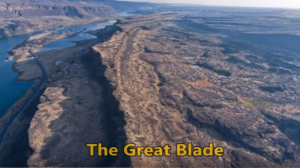
Relive Important Archive Articles

A large number of important articles get buried over time as new articles are added to our website, so here’s a chance to review and relive some of our most important articles. We think you might enjoy reviewing these timeless features.

Glacial Lake Missoula – Inspired Classroom Videos

The Glacial Lake Missoula chapter has worked with Inspired Classroom LLC to produce a series of 9 short (3-7 minute) videos exploring different aspects of the Ice Age Floods in the Glacial Lake Missoula area. The entire set is posted to the Inspired Classroom LLC YouTube channel, including a full 31 minute version (below) that compiles the entire set. 

Read More »

Could a Glacial Outburst Flood Repeat the “Younger Dryas” Cooling Event?

An ancient flood seems to have stalled the circulation of the oceans, plunging the Northern Hemisphere into a millennium of near-glacial conditions. Thirteen thousand years ago, an ice age was ending, the Earth was warming, the oceans were rising. Then something strange happened – the Northern Hemisphere suddenly became much colder, and stayed that way for more than a thousand years. For some time, scientists have been debating how this major climatic event – called the “Younger Dryas” – happened. The question has grown more urgent: Its answer may involve the kind of fast-moving climate event that could occur again. This week, a scientific team made a new claim to having found that answer. On the basis of measurements taken off the northern coasts of Alaska and Canada in the Beaufort Sea, the scientists say they detected the signature of a huge glacial flood event that occurred around the same time. This flood, they posit, would have flowed from the Arctic into the Atlantic Ocean and shut down the crucial circulation known as the “Atlantic meridional overturning circulation” (or AMOC) – plunging Europe and much of North America back into cold conditions. “Even though we were in an overall warming period, this freshwater, exported from the Arctic, slowed down the vigor, efficiency of the meridional overturning, and potentially caused the cooling observed strongly in Europe,” said Neal Driscoll, one of the study’s authors and a professor at the Scripps Institution of Oceanography. The work, published in Nature Geoscience, was led by Lloyd Keigwin of the Woods Hole Oceanographic Institution along with researchers at that institution, Scripps and Oregon State University. The result remains contested, though, with other researchers still arguing for different theories of what caused the Younger Dryas – including a very differently routed flood event that would have entered the ocean thousands of miles away. Nonetheless, the story is relevant because today, we’re watching another – or rather, a further – deglaciation, as humans cause a warming of the planet. There is also evidence that the Atlantic circulation is weakening again, although scientists certainly do not think a total shut-off is imminent, and are still debating the causes of what is being observed. Either way, the new research underscores that as the Earth warms and its ice melts, major changes can happen in the oceans. And could happen again. The researchers behind the current study, working on board the U.S. Coast Guard Cutter Healy, analyzed sediments of deep ocean mud, which contain the shells of long-dead marine organisms called foraminifera. In those shells, the scientists detected a long-sought-after anomaly recorded in the language of oxygen atoms. The shells contained a disproportionate volume of oxygen−16, a lighter form (or isotope) of the element that is found in high levels in glaciers. That is because oxygen−16, containing two fewer neutrons and therefore lighter than oxygen−18, evaporates more easily from the ocean but does not rain out again as readily. As a result, it often falls as snow at high latitudes and is stored in large bodies of ice. “This is the smoking gun for fingerprinting glacial lake outbursts,” Driscoll said. And that means the findings may also represent the trigger for the Younger Dryas. The thinking is that as the ice age ended and the enormous Laurentide ice sheet atop North America began to retreat, the resulting meltwater fed a bevy of large lakes atop the depressed surface of the continent. That included the massive glacial Lake Agassiz, which stretched from the Great Lakes northwestward across much of Canada. The approximate maximum extents of major glacial lakes that formed from the retreat of the western Laurentide Ice Sheet. (Shannon Klotsko, Scripps Institution of Oceanography, University of California at San Diego) Prior research had shown that for a while, much of the resulting freshwater drained down the Mississippi River and into the Gulf of Mexico. But at some point, as the ice sheet continued to shrink, the flow of water appears to have been suddenly rerouted to the north or to the east, where it could do more potential damage to the ocean circulation in the Atlantic. There has long been scientific debate about where all the meltwater actually entered the ocean, though – with some contending that it would have occurred through the St. Lawrence River, which flows past today’s Montreal and Quebec City and thus out into the Atlantic. The new research holds that, instead, the floodwater exited through the Mackenzie River, which stretches across today’s Northwest Territories, emptying straight into the Arctic Ocean. It would certainly have been an enormous flow of fresh water. “I would say somewhere between the Mississippi and the Amazon,” Keigwin said. That could have interfered with the Atlantic circulation, which is crucial because it carries warm water northward, and so heats higher latitudes. Eventually, the waters of the circulation become very cold as they travel northward, but because they are also quite salty, they sink because of their high density and travel back south again. Freshening is therefore the Achilles’ heel of the circulation. And the new study argues that although the glacial water would have entered the seas very far away near the present Alaska-Canada border, it would have then circulated around the Arctic, eventually traveling south past Greenland and entering the key regions that are crucial to the overturning circulation, which tend to be off Greenland’s southern coasts. Not everyone is convinced, though – including some researchers who have previously published results suggesting that the outburst flood or flow was instead to the east, through the St. Lawrence River. “They have produced a nice signal of the release of freshwater into the Arctic Ocean, but the conclusions are based on an uncertain chronology which, when trying to tie together events so closely, requires some independent confirmation,” Peter Clark, an Oregon State University geoscientist who has published evidence supporting the St. Lawrence River theory, said in an email. Anders Carlson, Clark’s co-author and colleague at Oregon State University, sent a geological study finding that, as he put

Read More »

Lava + Ice + Water = Floods Geology

Floods of lava (Columbia River Basalts) and Ice Age Floods of water (Lake Missoula floods and the Bonneville Flood) are world-famous topics among geologists. To have both sets of floods in the same area means the geology of the Inland Northwest is truly Disneyland for Geologists! The program begins in Lewiston, Idaho where the floods of lava and water are beautifully on display near the mouth of Hells Canyon. Early on, the Columbia River Basalts – eruptions of fluid lava from deep fissures – are featured. The Missoula Floods from Montana and the Bonneville Flood from Utah – the Ice Age Floods – are surveyed at an introductory level. And finally, the interaction between bedrock and fluid dynamics of the floodwater are highlighted through discussion of Ice Age erosional and depositional landforms. Key locations in the Pacific Northwest are featured, including the Snake River Canyon, Grand Coulee, Dry Falls, the Drumheller Channels, Wallula Gap, and the Columbia River Gorge. Tom Foster and Nick Zentner (Central Washington University) had been hiking together in eastern Washington for years. The result? A series of short videos that showcase geological wonders in the Pacific Northwest. This 16-minute video – Huge Floods in the Pacific Northwest – offers an introductory overview of spectacular geologic events that impacted much of Washington, Oregon, and Idaho. More than a dozen “2 Minute Geology” episodes are now available on Nick’s 2-Minute Geology YouTube channel.

Read More »

Model for a Missoula Flood

ICYMI (in case you missed it) — Floodwaters rise more than 1,000 feet as they slam into the Columbia River Gorge from the east. The torrent blasts through the narrows at 60 mph, carrying truck-size boulders and house-size icebergs. Reaching Portland, water loaded with gravel and dirt roils to a depth of 400 feet, leaving tiny islands at the summits of Mount Tabor and Rocky Butte. Geologists have spent decades piecing together evidence to tell the story of the great Missoula floods that reshaped much of Oregon and Washington between 18,000 and 15,000 years ago. Now scientists have found a way to travel back in time to watch the megafloods unfold, in a virtual bird’s eye view. Their computer simulation displays the likely timing and play-by-play action, starting with the collapse of an ice dam and outpouring of a lake 200 miles across and 2,100 feet deep. The computer model, developed by Roger Denlinger with the U.S. Geological Survey in Vancouver and Colorado-based geophysicist Daniel O’Connell, is filling gaps in scientific explanations of the floods and the baffling landforms they left, including the fabled Channeled Scablands — scars hundreds of miles long cut into the bedrock of eastern Washington and visible from outer space. The simulations also may help settle a lingering scientific controversy about what caused the repeating ice-age catastrophes. “It’s just really powerful visualization that gives a sense of the scale of the floods, how they came down through the channel system and backed up the big tributary valleys,” said Jim O’Connor, a hydrologist with the U.S. Geological Survey in Portland who has written extensively on the Missoula floods. He said the modeling work provides the first “really good information” on the timing of events. During the last ice age, a continent-spanning ice sheet built from massively expanded glaciers descended from the Canadian Rocky Mountains to reach deep into Washington, Idaho and Montana. Glacial Lake Missoula formed behind a miles-long dam of ice across what is now the valley of the Clark Fork and Pend Oreille rivers running from Montana to northeast Washington. The dam formed and collapsed dozens of times over a span of three thousand years. In the simulation of one of the largest possible floods, raging water quickly overwhelms the hills near Spokane and races overland to the south and west. The intense, overland flows carve the miles-long scars of the scablands between Spokane and Pasco, Wash. Thirty-eight hours later, swirling, mud-darkened waters converge at the narrowing of the Columbia at Wallula Gap, where the backed-up flow rises 850 feet above river level (1,150 feet above sea level). An immense volume of water blasts through the narrows at fire-hose velocity. Flow exceeds 1.3 billion gallons per second — a thousand times greater than the Columbia’s average flows today. Lake Missoula’s water, all 550 cubic miles of it, drains in 55 hours — less than three days — according to the model. At that time, the flood surge peaks in the Columbia Gorge at The Dalles, rising 950 feet above river level (1,000 feet above sea level), spilling over the gorge walls in places, and flooding the valleys of tributaries for miles upstream. Inundation of the Willamette Valley peaks on the seventh day after dam burst, in the simulation. Flooding reaches as far south as Eugene. Loaded with mud and gravel, the flood dumps sediment across the entire valley. Repeated floods build a layer 100 feet thick in Woodburn. Such a vast inundation, far greater than anything ever witnessed in historical time, seemed impossible to geologists in the 1920s, when J Harlen Bretz proposed that the scablands resulted from a catastrophic flood, not eons of gradual erosion. The idea didn’t gain mainstream acceptance until the 1960s. Since then, geologists have found evidence that Lake Missoula emptied catastrophically dozens of times during the last ice age. But controversy persists. A few scientists assert that the cataclysmic floods must have had multiple sources, not just an outburst from Lake Missoula. John Shaw of the University of Alberta in Edmonton, for instance, has proposed that an enormous reservoir beneath the ice sheet over much of central British Columbia boosted the flooding. The new simulation suggests that discharge from Lake Missoula alone would have been powerful enough. The simulated flood reaches peak stages all along its route that match the evidence visible today in sediment, with one big exception: At Wallula Gap, water levels in the simulation fell short by as much as 130 feet. “It’s pretty clear, if Lake Missoula is enough to hit all the other high water marks, you don’t need another source of water,” Denlinger said. Calculating the convoluted paths of such a massive flood requires an immense amount of number crunching. Simulating one flood requires more than 8 months of computer time, Denlinger said. But the computer simulation isn’t likely to end the debate. The fact that it can’t reproduce the maximum flooding at Wallula Gap leaves room for doubts. And some experts say there is direct evidence for an additional source of flood waters from beneath the ice sheet that covered the Okanagan Valley. “It is conceivable that other valleys in southern British Columbia contributed water to the scablands but the field evidence necessary to test these possibilities has not been fully documented,” said earth scientist Jerome-Etienne Lesemann at the University of Aarhus in Denmark. “There are a number of unanswered questions,” he said. “That makes the whole Channeled Scablands story a really interesting and intriguing geological puzzle.” Reprinted from The Oregonian, original article by Joe Rojas-Burke, 2010

Read More »

Smithsonian Article about the Ice Age Floods

Ice Age Floods Smithsonian Article Devastating Ice Age Floods That Occurred in the Pacific Northwest Fascinate ScientistsThe Scablands were formed by tremendous and rapid change, and may have something to teach us about geological processes on Marsby Riley Black – Science Correspondent – April 19, 2022 for Smithsonian Magazine The Earth seems to change slowly. Continents shift by about half an inch in a year. Sea levels rise by less than a quarter of an inch in the same amount of time. Mountains are constantly being eroded but, to us, seem to stand today just as they did yesterday and the day before. Our planet’s geological history often seems like one of slow, grinding change. But that’s hardly the whole story. Sometimes geological change comes startlingly, violently fast, leaving scars on the Earth’s surface. The Channeled Scablands of the Pacific Northwest, a landscape full of flat-topped plateaus that rise between steep-walled canyons, are among the vastly-altered landscapes that have caused researchers to rethink what they previously presumed. The geologic wounds are dramatic evidence that quick and catastrophic changes have played a significant role in shaping our planet. The Scablands, principally located in southeastern Washington state, bear the signs of an incredible Ice Age event. Between 14,000 and 18,200 years ago, huge glacial lakes on the boundaries of ice sheets burst from their natural dams and rushed over the landscape, scouring the hills and dropping massive stones as they went. Entire hills were washed away as the floodwaters dumped gravel, boulders and sediment in new places, almost like shaking a great geological Etch-a-Sketch. But this is a relatively new understanding, only broadly accepted since the 1970s. It took decades for geologists to construct even an outline of what the Scablands represent, a realization that proved to be a turning point for science. For if intense floods could carve such features once in Earth’s history, surely they could have changed landscapes at other times and in other places—even those as far away as the Martian surface. Geologists only began to pick up on the story of the Scablands a century ago. In the 1920s, naturalist J Harlen Bretz wrote several descriptive papers on the strange basins and odd channels of the area. Those channels had been created by moving water, but the way water had once flowed through the area seemed to make no sense. “The channels run uphill and downhill, they unite and they divide, they head on the back-slopes and cut through the summit,” Bretz wrote, “they could not be more erratically and impossibly designed.” The only reasonable conclusion, Bretz proposed, was that the Scablands were created by massive and short-lived floods. Bretz’s colleagues were not ready for such a conclusion. Ever since geology came into its own as a science in the 19th century, much of the field has been influenced by the concept of uniformitarianism—that the present is the key to the past. In a broad sense, that’s an excellent rule. The Earth is still changing, and many of those alterations—from erosion to volcanic eruptions—also occurred in the past. But some additional stipulations to the older formulation of the idea were unnecessarily taken as truth. One of them was that the Earth is changing at a slow, gradual rate and that quick, catastrophic change was impossible. Bretz’s idea for how the Scablands formed flew in the face of what many geologists accepted. Channels were carved over long periods of time by rivers, other geologists thought, not by sudden floods. To Bretz, the evidence was unmistakable. Among other things, the Scablands contained layers of gravel hundreds of feet high. Slow-moving streams couldn’t have left such vast accumulations. Pieces of gravel are larger and heavier than particles of sand or silt, requiring faster-moving water to pick up the gravel and transport it. Gravel deposits as tall as skyscrapers must have required an incredible amount of fast-flowing water. The pattern was consistent with the underlying geology of the area, as well. The rock beneath the massive flood deposits was relatively friable volcanic rock, easily broken and carved. The fragility of these rock layers allowed the floods to gouge out channels and canyons in a way that harder rocks would have been more resistant to. Yet the fact that Bretz couldn’t identify the source of the floodwaters caused many to dismiss his idea, and it wasn’t until evidence of similar events—such as Ice Age flood beds found in Montana—that other experts began to reconsider what Bretz had proposed. Eventually, by the 1970s, dismissive geologists changed their tune. Something catastrophic truly did transpire to create the Scablands. Not that the behavior or history of such floods are completely understood. “There are loads of outstanding questions and many people are thinking carefully about the Scablands,” says University of Washington geology PhD candidate Kelsay Stanton. Even though experts are confident that vast glacial lakes provided the water for the floods, the precise volumes of the repeated floods are unknown, and the timing of the dozens of outbursts has yet to be determined in detail. “The glacial outburst flooding of the Pacific Northwest is hardly a closed subject,” Stanton says. Part of what’s allowing geologists to keep going back to the Scablands is that the tools available to scientists have changed a great deal since Bretz’s time. “There are lots of geochronology and computer modeling methods now that weren’t available when Bretz and other early researchers were mapping the area,” says University of Massachusetts Amherst geology PhD candidate Karin Lehnigk. These repeated floods affected the ocean, she notes, with the influx of freshwater reducing the saltiness of the northern Pacific for years and altering the way colder, saltier water in deep ocean layers circulated. The floods affected more than the land they ran over, and have acted as models for how our modern glaciers might alter ocean circulation as they melt due to global warming. New, broad scale methodologies can offer some of these insights and these refined techniques have proved to be critical, as no one has ever

Read More »

The Cerutti Mastodon Site – A Bretz Type Controversy of Our Time

In March, while visiting San Diego, I went to the San Diego Museum of Natural History in Balboa Park and toured the remarkable Cerutti Mastodon Site exhibit. This controversial exhibit of a mastodon site is notable for its claim that the mastodon’s bones were broken by humans 130,000 years ago, making it far older than any other such site in North America. The signs at the beginning of the exhibit read as follows; “The Cerutti Mastodon discovery. A San Diego find reveals the earliest evidence of of human life in North America. In 1992, paleontologists from the San Diego Natural History Museum were surveying a highway construction site to identify and salvage any fossils that might be unearthed. “Field paleontologist Richard Cerutti spotted some bones and tusks. Exploring further, the team discovered that these were bones of a mastodon-an extinct relative of elephants. “But Richard noticed something unusual. The bones were mysteriously broken and the pieces separated. “It took 22 years for scientists to solve the riddle. Once they did, they realized that this local site is evidence of human presence on this continent 130,000 years ago-much earlier than we thought possible. “In 2014, scientists made a new discovery about the age of the Cerutti Mastodon Site. How did this happen? Scientists figured out the age of the mastodon bones using radiometric dating. It’s a way of telling how old a rock or fossil is by measuring its radioactive isotopes. “A radioactive isotope transforms into an isotope of a different element over time. If you know the rate at which the “parent” isotope transforms into its “daughter” isotope, measuring the parent-daughter ratio tells you how old the material is. “Scientists used a method that measures the ratio of the radioactive isotope uranium-234 to its daughter isotope thorium-230. Dramatic improvements in this method have made it a highly accurate means of dating very old materials- up to 500,000 years. In 2014, scientists used this method to date bones at the Cerutti Mastodon Site. “The results were clear. The bones are approximately 130,000 years old.” More than two decades after the Cerutti mastodon’s discovery in southern California in 1993, USGS scientist Dr. James Paces was sent several bones of unknown age. The specimens were important because they came from a site with abundant evidence of processing by ancient humans. Advances in analytical capabilities and the understanding of processes that incorporate natural uranium and its decay products in fossil bone provided archaeologists with a radiometric dating tool that, at least in some cases, could confidently and accurately determine ages for these older materials. After analyzing nearly 100 subsamples from multiple specimens, Dr. Paces determined that the mastodon bones—which were still fresh when someone fractured them using hammerstones and rock anvils—were covered with sediments 131,000 years ago, give or take about 9,000 years. This result indicates that some form of archaic humans arrived in the Americas more than 100,000 years earlier than scientists had thought possible. Following the dating of the bones officials at the Natural History Museum began making plans for a permanent exhibit about the discovery. The exhibit opened in 2017. It is very thorough and includes bones, alleged hammerstones, and anvil rocks from the original mastodon site as well as numerous photos and interpretive panels. When J Harlen Bretz first announced in the 1920’s his theory that the scablands of eastern Washington State had been carved out by a cataclysmic flood he met stiff opposition. What he was proposing was so far out of the mainstream of geological thinking of the time that many scientists couldn’t accept it. Schooled in uniformitarianism they believed that earth’s landforms were all created by slow gradual processes operating over time and that an event of the magnitude Bretz was proposing just wasn’t possible. They tried to come up with alternative explanations for the facts Bretz presented that fit in with their current frame of reference. Yale University geologist Richard Foster Flint famously said of certain flood features in the scablands that they presented “a picture of leisurely streams with normal discharge.” The claim by San Diego’s Natural History Museum that the Cerutti site is 130,000 years old is likewise far outside what many scientists of our time are ready to accept. Other similar sites are much younger. For example Sequim’s famous mastodon site is only 13,800 years old. If the San Diego Natural History Museum is correct it totally rewrites the history books about humans in North America. It places humans in North America during a previous interglacial period. It would establish that humans had long since been in North America during the time of the comparatively recent ice-age floods. Critics of the Natural History Museum, and there are many, point to things like what they consider to be a lack of lithics from the site. Others speculate that the signs of bone breakage observed at the site may have been caused by some other creature besides humans or by modern day construction equipment. But the Natural History Museum counters that none of the critics have provided a satisfactory alternative explanation for the evidence that they’ve presented. Cerutti and his team of researchers and the San Diego Natural History Museum remain unequivocal in their conclusion: The Cerutti Mastodon Site is a 130,000 year old archaeological site. – by Mark Sundquist, Puget Lobe Chapter “Ideas without precedent are generally looked upon with disfavor and men are shocked if their conceptions of an orderly world are challenged.” J Harlen Bretz 1928 “Extraordinary claims require extraordinary evidence – each aspect requires the strongest scrutiny,” Chris Stringer

Read More »

Missoula Flood Rhythmites

Lake Missoula filled many times and emptied catastrophically in many Missoula Floods. Rhythmite sequences [a series of repeated beds of similar origin] at numerous localities provide this evidence: slack-water rhythmites in backflooded tributary valleys below the dam indicate multiple floods, and varved rhythmites in Lake Missoula attest to multiple fillings of the lake. Below the dam, most slack-water rhythmites are graded beds deposited by flood bores surging up tributary streams. They grade upward from coarse sand and gravel to silt, with occasional ice-rafted erratics. The tops of some rhythmites are marked by thin paleosols, or buried soil horizons, which indicate a period of subaerial exposure. Thus, each rhythmite represents a separate flood event, and each deposit records multiple floods. The most complete record occurs at Sanpoil Valley, an embayment on the north side of Lake Columbia, where varved rhythmites document 89 flood events, with the period of time between floods initially increasing to a maximum of about 50 years and then decreasing to less than 10 years. Thousands of varves were deposited in Lake Missoula. At the best-known Ninemile locality near Missoula, about 40 rhythmites consist of varves overlain by a sand/silt layer. The varves were deposited on the floor of Lake Missoula, and the sand/silt layers represent subaerial exposure and deposition in a stream. The number of varves in each rhythmite varies from 9 to 40, decreasing regularly upward, and the total number of varves is just less than one thousand. An interpretation of these data would suggest: [1] Lake Missoula filled and emptied [in a catastrophic flood] about 40 times, [2] it took 9 to 40 years to fill the lake, each successive lake requiring less time, and [3] the process was repeated over a period of about one thousand years. Because Ninemile is about in the middle of the very long lake, the record here would not provide a complete history of the lake. Correlating Ninemile with the downstream record would suggest these events were in the latter half of the entire flood history.

Read More »

New Saber-Toothed Cat Species May Have Hunted Rhinos in America

Using detailed fossil comparison techniques, scientists have been able to identify a giant new saber-toothed cat species, Machairodus lahayishupup, which would have prowled around the open spaces of North America between 5 and 9 million years ago. One of the biggest cats ever discovered, M. lahayishupup is estimated in this new study to have a body mass of some 274 kilograms (604 pounds) or so, and possibly even bigger. It’s an ancient relative of the well-known Smilodon, the so-called saber-toothed tiger. A total of seven M. lahayishupup fossil specimens, including upper arms and teeth, were analyzed and compared with other species to identify the new felid, with the fossils collected from museum collections in Oregon, Idaho, Texas, and California. Upper arms are crucial in these cats for killing prey, and the largest upper arm or humerus fossil discovered in the study was about 1.4 times the size of the same bone in a modern-day lion. That gives you an idea of just how hefty and powerful M. lahayishupup would have been. “We believe these were animals that were routinely taking down bison-sized animals,” says paleontologist Jonathan Calede from Ohio State University. “This was by far the largest cat alive at that time.” Rhinoceroses would have been abundant at the same and may have been animals that M. lahayishupup preyed on, alongside camels and sloths significantly bigger than the ones we’re used to today. Peering back so many millions of years into the past isn’t easy, and the researchers say that a more detailed saber-tooth cat family tree is going to be needed to work out exactly where this species fits in. The findings also open up some interesting evolutionary questions about these giant cats. “It’s been known that there were giant cats in Europe, Asia, and Africa, and now we have our own giant saber-toothed cat in North America during this period as well,” says Calede. “There’s a very interesting pattern of either repeated independent evolution on every continent of this giant body size in what remains a pretty hyper-specialized way of hunting, or we have this ancestral giant saber-toothed cat that dispersed to all of those continents. It’s an interesting paleontological question.” Excerpted from SCIENCE ALERT article by DAVID NIELD8 MAY 2021

Read More »