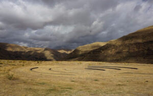
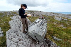
Relive Important Archive Articles

A large number of important articles get buried over time as new articles are added to our website, so here’s a chance to review and relive some of our most important articles. We think you might enjoy reviewing these timeless features.

Hiking Drumheller Channels

Hiking Drumheller Channels Ice Age Floods National Geologic Trail There are scads of hiking trails all through Drumheller Channels National Natural Landmark. On a cloudy day in early June we took off on a couple of exploratory hikes that were simply amazing. We first proceeded south from the parking lot at Lower Goose Lake, running through late Spring wildflowers, eventually looking for one of Bruce Bjornstad’s geocaches. We wandered over hills and down into deeper valleys, always surrounded by the towering walls of basalt defining that section of Drumheller Channels. Along the way we found an area of apparent Kolk depressions with odd spires of basalt poking up out of the middle of a central mound. Soon we passed through a reedy area that bounded the southern edge of Lower Goose Lake. We continued on south to the edge of Black Lake where the geocache was supposed to be, but after 20 minutes with 4 of us looking in the area of the GPS coordinates, we finally decided the cache was no longer there and headed back. The hike was easy, very pleasant, and mercifully cool due to the cloudy morning. We then drove north across the O’Sullivan Dam, and back south through Columbia National Wildlife Refuge to the W. McManamon Road entrance to Crab Creek Marsh Unit #3 and the Basalt Columns at Drumheller Trailhead, the kickoff point to go to the top of “Nick’s Columns”. Nick Zentner’s videos about the columns are great, but the blooper where his rock hammer falls down between columns is priceless. We just had to see those columns for ourselves, and we weren’t disappointed. It’s interesting how only the columns along the edge are free standing, while those inboard are packed around with sediment. The little rain the area gets probably washed the sediment out of the spaces between the bordering columns. After walking around for a while we made our way back to the car and drove to the Drumheller Channels National Natural Landmark overlook for a final sweeping viewpoint. The entire area is huge and worth several days of exploring, but it’s also pretty easy to have a great time in just a few hours. This is a place you just have to experience. Quick Facts  Location: Adams County, Washington 99371

Read More »

Bering Land Bridge Formed Surprisingly Late During Last Ice Age

By reconstructing the sea level history of the Bering Strait, scientists found that the strait remained flooded and the Bering Land Bridge connecting Asia to North America did not emerge until around 35,700 years ago, less than 10,000 years before the height of the last ice age (known as the Last Glacial Maximum), and not long before humans are thought to have begun migrating into the Americas. The new findings indicate that the growth of the ice sheets—and the resulting drop in sea level—occurred surprisingly quickly and much later in the glacial cycle than previous studies had suggested. “It means that more than 50 percent of the global ice volume at the Last Glacial Maximum grew after 46,000 years ago,” said Tamara Pico, assistant professor of Earth and planetary sciences at UC Santa Cruz and a corresponding author of the paper. “This is important for understanding the feedbacks between climate and ice sheets, because it implies that there was a substantial delay in the development of ice sheets after global temperatures dropped.” Global sea levels drop during ice ages as more and more of Earth’s water gets locked up in massive ice sheets, but the timing of these processes has been hard to pin down. During the Last Glacial Maximum, which lasted from about 26,500 to 19,000 years ago, ice sheets covered large areas of North America. Dramatically lower sea levels uncovered a vast land area known as Beringia that extended from Siberia to Alaska and supported herds of horses, mammoths, and other Pleistocene fauna. As the ice sheets melted, the Bering Strait became flooded again around 13,000 to 11,000 years ago. The new findings are interesting in relation to human migration because they shorten the time between the opening of the land bridge and the arrival of humans in the Americas. The timing of human migration into North America remains unresolved, but some studies suggest people may have lived in Beringia throughout the height of the ice age. “People may have started going across as soon as the land bridge formed,” Pico said. The new study used an analysis of nitrogen isotopes in seafloor sediments to determine when the Bering Strait was flooded during the past 46,000 years, allowing Pacific Ocean water to flow into the Arctic Ocean. First author Jesse Farmer at Princeton University led the isotope analysis, measuring nitrogen isotope ratios in the remains of marine plankton preserved in sediment cores collected from the seafloor at three locations in the western Arctic Ocean. Because of differences in the nitrogen composition of Pacific and Arctic waters, Farmer was able to identify a nitrogen isotope signature indicating when Pacific water flowed into the Arctic. Pico, whose expertise is in sea level modeling, then compared Farmer’s results with sea level models based on different scenarios for the growth of the ice sheets. “The exciting thing to me is that this provides a completely independent constraint on global sea level during this time period,” Pico said. “Some of the ice sheet histories that have been proposed differ by quite a lot, and we were able to look at what the predicted sea level would be at the Bering Strait and see which ones are consistent with the nitrogen data.” The results support recent studies indicating that global sea levels were much higher prior to the Last Glacial Maximum than previous estimates had suggested, she said. Average global sea level during the Last Glacial Maximum was about 130 meters (425 feet) lower than today. The actual sea level at a particular site such as the Bering Strait, however, depends on factors such as the deformation of the Earth’s crust by the weight of the ice sheets. “It’s like punching down on bread dough—the crust sinks under the ice and rises up around the edges,” Pico said. “Also, the ice sheets are so massive they have gravitational effects on the water. I model those processes to see how sea level would vary around the world and, in this case, to look at the Bering Strait.” The findings imply a complicated relationship between climate and global ice volume and suggest new avenues for investigating the mechanisms underlying glacial cycles. In addition to Pico and Farmer, the coauthors include Ona Underwood and Daniel Sigman at Princeton University; Rebecca Cleveland-Stout at the University of Washington; Julie Granger at the University of Connecticut; Thomas Cronin at the U.S. Geological Survey; and François Fripiat, Alfredo Martinez-Garcia, and Gerald Haug at the Max Planck Institute for Chemistry in Germany. This work was supported by the National Science Foundation. Published  in Proceedings of the National Academy of Sciences. Reprinted from UC Santa Cruz Newsletter, By Tim Stephens

Read More »

Steamboat Rock

Steamboat Rock lies at the very northern end of the Grand Coulee. At over 1 mile long, ⅔ mile wide, and 800 feet high. The basalt-topped butte standing alone in the middle of the coulee, almost completely surrounded by the waters of Banks Lake is an incredible sight. It was left behind by erosion of both the Ice Age Floods that carved the Grand Coulee, and the Okanogan Lobe of the ice-age continental ice sheet. Because this area is near the thinning outer margin of the Columbia River Basalt extent, it’s easy to see Columbia River Basalt directly overlying older granitic basement from the trails around the base. A steep climb on a well constructed trail leads to the broad top of Steamboat Rock where the views are truly expansive, encompassing a full 360° panorama. It’s also easy to find granitic erratics and glacial till atop the butte that attest to the fact that the Okanagan Lobe overrode Steamboat Rock during the most recent Ice-Age glacial advance. The campgrounds at the State Park are spacious and well laid out. There is easy access to both the trails and to Banks Lake for fishing, boating and swimming. Most of the water in Banks Lake has been pumped up from the Columbia River’s Lake Roosevelt, and impounded by a dam 20 miles south at Coulee City. Banks Lake is a key element in the Columbia Basin Project that supplies water for the verdant agricultural areas to the south in an otherwise quite dry, high desert environment. Some other interesting places to explore in the area include Northrup Canyon, Grand Coulee Dam, and the quixotic Gehrke Windmill Garden just north of Electric City.

Read More »

Columbia Gorge Geology in 22:22 Minutes

This video by Tom Foster and Nick Zentner about the Columbia River Gorge features an incredible variety of geology and human history as it slices through the Cascade Range of the Pacific Northwest. The Columbia River Basalts, the Missoula Floods, the Bonneville Flood, the Bridge of the Gods, Celilo Falls, Multnomah Falls, Beacon Rock, Lewis and Clark, the Oregon Trail, the Columbia River Highway, and more!

Read More »

Uncovering a Columbian Mammoth

There’s a Columbian Mammoth hiding out in Coyote Canyon down Kennewick way, and MCBONES Research Center Foundation is working to uncover his/her hiding place. For a small contribution you can tour this hide-and-seek site, or you can volunteer to help uncover the hidden mammoth. Sound interesting? Find out more in this short video produced by Mark Harper of “Smart Shoot“, or visit the MCBONES website. The Mid-Columbia Basin Old Natural Education Sciences (MCBONES) Research Center Foundation provides local K-12 teachers and their students, as well as other volunteers, an opportunity to actively participate in laboratory and field-based research in paleontology, geology, paleoecology, and other natural sciences primarily within the Mid-Columbia Region of southeast Washington State.

Read More »

Traveling the Ice Age Floods National Geologic Trail

In September 2021 my wife and I took a trip to see what was new along the Ice Age Floods National Geologic Trail and visit some places we did not make it to in our very first trip in 2004. The IAFI chapter brochures were very helpful in learning what there was to see in each area. We also remembered a preview of the National Parks Service unigrid map brochure that will come out hopefully later this year, so be sure and get one when it debuts. The other excellent tool was the online interactive map on the Ice Age Floods Institute website (https://iafi.org/floodscapes/), where you can click on a spot and see a photo and description of the site. All are great planning tools. We drove to Missoula, Montana and stayed there a couple of days as we made day trips. Our first one was to Ovando to see a granite glacial erratic that the Glacial Lake Missoula Chapter had etched and placed at the high-water line. You will find it at Trixi’s Antler Saloon which is a nice place to grab a bite for lunch. The chapter has a number of these high water markers placed already and have more planned to show the full extent of Glacial Lake Missoula. Unfortunately, due to the smoke from the wildfires we were not able to go to Hamilton to see the 8-ton granite erratics outside Ravaili Museum with four interpretive signs outside and additional displays inside. We drove up to the Paradise Center in Paradise, Montana. We had been there before in 2016 for the fall IAFI field trip and they were just dreaming of what the old Paradise Elementary School could become. They have done a wonderful job of making that dream come true. It was one of our favorite spots on this trip. They have dedicated an entire room to the Ice Age Floods story where an extremely accurate 3-D map of Glacial Lake Missoula has lights installed so you can push a button to light up the edge of the ice lobe and other features. Besides information about the Ice Age Floods, the Center also has wonderful displays about the trains & train yard that used to be in Paradise and the history of the Paradise Elementary School. We went to the Natural History Museum in Missoula and enjoyed the panels and video which told the Lake Missoula Floods story and also about Joseph Pardee, a very important pioneer in solving the mystery of these Floods. This museum also displays an amazing amount of taxidermy showing the wildlife and birds in the region. On our way up to Sandpoint, Idaho we passed through Eddy Narrows. Glacial Lake Missoula drained through this canyon going 80 mph leaving horizontal marks high up on the walls. Previously these were thought to be glacial striations, but Pardee speculated that these marks were from huge boulders as they shot through the Narrows. The Narrows is long with few places you can pull over on Highway 200, so it can be hard to really appreciate its scope. We got a good view from the Koo-Koo-Sint Bighorn Sheep Viewing Interpretive Site which has several interpretive signs that talk about the sheep and the geology of the Clark Fork River Valley. We then went over to Farragut State Park at the southern tip of Lake Pend Oreille to view the beginning of the outburst plain that formed the Rathdrum/Spokane Valley aquifer. Across Lake Pend Oreille is Green Monarch Ridge; the terminus of the Purcell Trench which held the 4,000 ft. ice dam that carved the steep walls. The display at the museum has several interpretive panels. The next day we met Consuelo Larrabee who gave us a personal tour of the 40,000 square foot Ice Age Floods Playground in Riverfront Park in Spokane, Washington. She and Melanie Bell, the president of the Cheney-Spokane chapter, did an enormous amount of work as consultants on this fabulous, themed park.  Kids can learn as they play on the three-story Columbian slide tower, Glacial Dam splash pad, log jam climber, an alluvial deposit fossil dig, and more. The park was filled with kids and the adults were enjoying it as much as the kids. We loved watching the excitement of a child as she saw the splash pad water fountains simulate the ice dam starting to rupture and then the cascade of water flooding over the manmade basalt rocks. Along the side of the building are actual basalt columns and the fossil dig led to many exciting discoveries by the children as they dug through the sand to reveal embedded replicas of fossils. Throughout the park are thoughtfully placed benches for people to sit and watch the fun going on around them. There are nine interpretive panels throughout the park adding a wonderful educational benefit to all the fun. This park will be quite a prize for years to come. The next day we drove along Highway 262 to W. McManamon Road to the Drumheller Channels National Natural Landmark. This outlet from the Quincy Basin, with floodwaters going 65 mph eroded not just the topsoil but the underlying basalt which created dramatic channels, basins, potholes and buttes. The viewpoints along the drive had several interpretive panels talking about these wonderful vistas. Since we live in Portland and this trip was to see places we had not recently seen, we skipped over the many wonderful places in the Columbia River Gorge, Willamette Valley & Tualatin. But for your trip, please check out the hundreds of beautiful and interesting sites to see in this region. The last stop for this trip was Cape Disappointment. The Floods debris flushing out the mouth of the Columbia River added substantially to submarine Astoria Fan and sediment cores have shown that ocean currents carried some of this debris all the way down to Cape Mendocino, California. Although not visible from the surface, the Park display has a relief map that shows the Astoria Canyon

Read More »

23,000 Year Old Human Footprints Found in New Mexico

Articles in Science Alert and the New York Times report on a well documented age for many sets of human footprints as old as 23,000 years in the ancient lake shore sands of White Sands, New Mexico. “The footprints were first discovered in 2009 by David Bustos, the park’s resource program manager. Over the years, he has brought in an international team of scientists to help make sense of the finds. Together, they have found thousands of human footprints across 80,000 acres of the park. One path was made by someone walking in a straight line for a mile and a half. Another shows a mother setting her baby down on the ground. Other tracks were made by children.” Beginning in 2019, two United States Geological Survey (USGS) research scientists, Dr. Jeffrey Pigati and Kathleen Springer, began working on the site and found ancient seeds of ditch grass associated with various sets of footprints. The oldest footprints so far have been found in seed beds radiocarbon age-dated as old as 22,800 years, and the youngest footprints dated to about 21,130 years ago. Some scientists still have concerns the seeds might have absorbed older carbon from the lake waters. But in general this research is strongly indicative that humans were present in the Americas long before the generally accepted 15,600-year-old footprint found in Chile or the 13,000 year age of human tools found near Clovis, NM. If humans were well established in New Mexico 23,000 years ago, they must have started spreading down from Alaska long before that. “That starts to wind back the clock,” said Dr. Reynolds of Bournemouth University. Some researchers feel the migration might have been along the coast during the last major ice advance of the Pleistocene, while others argue people could have traveled inland more than 32,000 years ago, before Ice Age glaciers reached their maximum extent and blocked off that route. Regardless of the possible migration route, this new evidence opens up new possibilities that humans may have been present in our local area even before the earliest of the Ice Age Floods, about 18,000 years ago. While the floods could have wiped away most traces of early people in the area, the window of human habitation may be much greater than scientifically documented to date.  

Read More »

Share this article:

Like this:

Like Loading...