Ice Age Floods: A Journey of Awakening – Susan Langsley
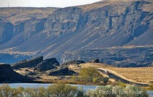
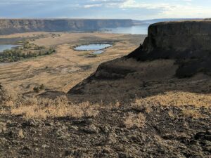
Do you ever hear the Led Zepplin song “Kashmir” in your head when contemplating the Ice Age Floods? “I am a traveler of both time and space. To be where I have been” –Robert Plant, Led Zepplin’s Kashmir My 11-year old daughter and I are on a 5-day, 4-night raft trip on the Lower Salmon river and we are having the time of our lives! Sun, sand, water, lovely food, games and some of the finest nicest Eastern Oregonians we have ever met. One of the guides is a sensitive and strapping young man who is a student at U of Oregon. He’s both an English major and a Geology major. What do you with that? You write about the soul of the earth, true love and adventure, river stories, deep thoughts that cross scientific paradigms. I see him becoming a teacher someday, maybe a science teacher like his Dad. And he’s a kayaker like me. What is so amazing about the Eastern Oregon guides is their familiarity with, connection to, and love of the river and land. They don’t fight traffic or get on the morning commute treadmill every day. There are no stoplights in the whole of Wallowa County, and the only food franchise is a Subway sandwich shop, no Costco or Walmart. Sure, they have school and work, but they are connected to and love the land they live on in deeper ways that us city folks miss. They are here to tell us about the land. They are guides. The 4th day on the river we pass a group of pillar-like rocks with beautiful symmetry. “That’s columnar basalt” my guide says, “The geologist who figured out the floods and travelled around these parts was J Harlan Bretz”. “J Harlan Bretz” I repeat, carefully, committing to memory. When I returned home to talk to my friend (who was a geology major at Wesleyan) about the trip, she replies “’J Harlan Bretz,’ Oh yes, I have all his books!” An Amazon search and I begin by reading a biography of J Harlan Bretz, “Bretz’s Flood” by John Soennichsen- (some guy from Eastern Washington… hmmm). And guess what: It’s so well-written, I can’t put it down! I am enthralled cover-to-cover with the character of J Harlan Bretz, his teaching method of taking students to the field (and floating them downstream on large Sequoia logs, upon occasion), his love of life, the serendipity of his study of the USGS Quincy Basin topo map when it first published, many summers spent driving around and measuring the Channeled Scablands, presenting his field evidence and theories at the Cosmos Club in Washington DC, and most of all his ability to KNOW he was RIGHT when all his colleagues scoffed and dismissed his theories. Now THAT man was a pillar of strength. Perhaps like a column of basalt? If he were alive today, Harlan Bretz could stand up to money-motivated physicians – the bad kind, nepotism in the school district, gossipers and bullies, and other types of corruption, all of which I have had to do to defend my younger child against since. J Harlan Bretz helped me to do this. He was a GREAT man! “All I see turns to brown.. And fills my eyes with sand as I try not see the wasted land” – Kashmir by Led Zepplin What was it about those floods, biblical in nature, that left behind a story of such jaw-dropping inspiration? Who are these people who live in Eastern Oregon and Washington and are so inspired by the landscapes there they are called to find new ways to study it, publish, write fantastic biographies? I continued my search to find other scholars of the Ice Age Floods, and that led me next to Nick Zentner and Bruce Bjornstadt. To be continued…