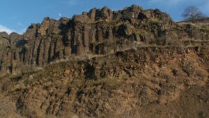
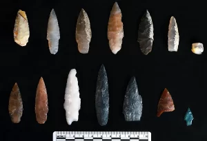
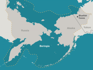
Relive Important Archive Articles

A large number of important articles get buried over time as new articles are added to our website, so here’s a chance to review and relive some of our most important articles. We think you might enjoy reviewing these timeless features.

13,000 Year-Old Human Footprints Found on BC Island

Big feet. Little feet. A heel here. A toe there. A digitally enhanced photo of a footprint found at Calvert Island, British Columbia that researchers dated to 13,000 years old. Credit Duncan McLaren Stamped across the shoreline of Calvert Island, British Columbia, are 13,000-year-old human footprints that archaeologists believe to be the earliest found so far in North America. The finding, which was published Wednesday in the journal PLOS One, adds support to the idea that some ancient humans from Asia ventured into North America by hugging the Pacific coastline, rather than by traveling through the interior. “This provides evidence that people were inhabiting the region at the end of the last ice age,” said Duncan McLaren, an anthropologist at the Hakai Institute and University of Victoria in British Columbia and lead author of the study. “It is possible that the coast was one of the means by which people entered the Americas at that time.” Dr. McLaren and his colleagues stumbled upon the footprints while digging for sediments beneath Calvert Island’s beach sands. Today, the area is covered with thick bogs and dense forests that the team, which included representatives from the Heiltsuk First Nation and Wuikinuxv First Nation, could only access by boat. At the close of the last ice age, from 11,000 to 14,000 years ago, the sea level was six to ten feet lower. The footprints were most likely left in an area that was just above the high tide line. “As this island would only have been accessible by watercraft 13,000 years ago,” Dr. McLaren said, “it implies that the people who left the footprints were seafarers who used boats to get around, gather and hunt for food and live and explore the islands.” They found their first footprint in 2014. While digging about two feet beneath the surface in a 20-square-inch hole, they saw an impression of something foot-shaped in the light brown clay. In 2015 and 2016, they returned and expanded the muddy pit. They discovered several more steps preserved in the sediment. The prints were of different sizes and pointed in different directions. Most were right feet. When the team was finished they had counted 29 in total, possibly belonging to two adults and a child. Each was barefoot. The researchers think that after the people left their footprints on the clay, their impressions were filled in by sand, thick gravel and then another layer of clay, which may have preserved them. Using radiocarbon dating on sediment from the base of some footprint impressions, as well as two pieces of preserved wood found in the first footprint, Dr. McLaren and his team found them to be 13,000 years old. That would make them the oldest preserved human footprints in North America. “It’s not only the footprints themselves that are spectacular and so rare in archaeological context, but also the age of the site,” said Michael Petraglia, an archaeologist from the Max Planck Institute for the Science of Human History in Germany who edited the paper for PLOS One but was not involved in the work. “It suggests an early entrance into the Americas.” Dr. Petraglia said the footprints also provided strong evidence for the coastal movement hypothesis and he added that they may have traveled the so-called “Kelp Highway,” a hypothesis that underwater kelp forests supported ecosystems down the North Pacific coast that helped ancient seafaring people hunt, develop and migrate. “The work is important because it shows the ‘real’ people, not just artifacts or skeletal remains,” said Steve Webb, a biological archaeologist at Bond University in Australia. “However, the footprints are limited in number and don’t shed light on activities or movement that tell us very much.” He added that future hunts for footprints should keep in mind that not everyone from this time period walked around barefoot. If anthropologists are too busy searching for soles, toes and arches, they might miss clues from those who wore animal skin shoes. Reprinted from New York Times – Earliest Known Human Footprints in North America Found on Canadian Island By NICHOLAS ST. FLEUR, March 28, 2018

Read More »

Frenchman Coulee

Frenchman Coulee Ice Age Floods National Geologic Trail Frenchman Coulee is a short drive north and west from the Silica Road exit 123 off US-90, along the Old Vantage Road. It is one of the most beautiful features left behind by the great Ice Age Floods. Several of those massive floods, up to 700 ft (213 m) deep, created Frenchman Coulee, its Potholes Coulee neighbor to the north, and scoured the bizarrely eroded surface of Babcock Bench, preferentially eroding weaker rock out of the top of the Grand Ronde Member of Columbia River Basalt. Frenchman Coulee is actually a dual coulee and cataract system, Frenchman Coulee and Echo Basin, separated by a remnant rock blade that sports tall basalt columns attracting rock climbers like bees to flowers. The Feathers is probably the most popular climbing area in the region. Hiking trails, some barely discernible, lead along and atop the rock blade, affording spectacular views of both coulees. Frenchman Coulee also has a waterfall in the eastern section of the Coulee that is accessible by foot. Other hiking and biking trails explore the floor of the coulee and continue over 15 miles north along Babcock Bench, perched high above and adjacent to the Columbia River, past Potholes Coulee and on to Crescent Bar. Quick Facts  Location: Old Vantage Highway, Quincy, WA 98848 A primarily destination for hikers, mountain bikers and rock climbers with the fascinating rock formations of the Gorge making for a great challenge

Read More »

The Great Blade – Bruce Bjornstad Video

“…there were a few double falls each member of which receded at approximately the same rate, so that the island in mid-channel became very much elongated, like a great blade, as the falls receded and the canyons lengthened.” J Harlen Bretz (1928) A tall, narrow basalt ridge, coined “The Great Blade” by J Harlen Bretz, parallels Lower Grand Coulee east of Lake Lenore. The blade is the product of Ice Age floods that repeatedly rampaged Grand Coulee as recently as 15,000 years ago. Most of the floods appear to have come from sudden outbursts from glacial Lake Missoula. During flooding the coulees on either side of the Great Blade were filled with up to 800 ft turbid water. The largest floods also overtopped the Great Blade, submerging the site under at least another 100 ft of floodwater. On the west side of the blade, where Lake Lenore is located, lies the Lower Grand Coulee, which ultimately migrated 10 miles northward – all the way to Dry Falls. On the east side of the blade is the higher East Lenore Coulee, which migrated a shorter distance (~3 mi) to Dry Coulee. Like a gigantic rib the Great Blade is tallest and narrowest at its south end, widening to the north. The blade extends for almost four miles from where the head of East Lenore Coulee intersects Dry Coulee. In places the blade narrows to as little as 800 ft wide. Video produced by Bruce Bjornstad for Ice Age Floodscapes

Read More »

“Hiding in Plain Sight”

Millions of people who visit and pass through the Gorge each year don’t realize the scope of the cataclysmic stories behind the stunning and tranquil beauty they are surrounded by. The Spring 2019 edition of The Gorge Magazine (page 50) attempts to address that premise with a feature article about the geology of the Columbia River Gorge titled “Hiding in Plain Sight“. The author, Gregg Harrington, who is not a geologist, used a private tour with Lloyd DeKay, president of the Columbia River Gorge Chapter, as well as other local geologists as a basis for much of the article. The article touches on 40 million years of Gorge geology, including the Ice Age Floods, and highlights some of the more interesting geological features of this popular tourist destination. Hopefully, articles like this, along with IAFI field trips, lectures and website, will help many recognize and realize some of the tumultuous story that lies behind the enchanting scenery, and make them “never see the Gorge in the same way again”. The magazine is available online and begins at page 50. We had hoped for an Ice Age Floods Institute website mention, but a planned “For more information” section was not included in the article. Still, the article covers a lot of interesting geology of an extremely popular destination, and an article like this is a significant contribution to our efforts to inform and educate the public about the Ice Age Floods.

Read More »

Pillow Basalt and Palagonite – Lava Flowing into Water

Pillow basalt and palagonite are the result of lava flowing into water. We have a striking example in the Columbia River Gorge at the intersection of Hwy 30 and US 197 at the east end of The Dalles. This video gives a good idea of how these basalt pillows form and what they look like. 

Read More »

Explore the Columbia River Gorge

The Columbia River Gorge is an incredibly popular area to visit, and that’s for good reason, the setting is uniquely spectacular. The Gorge encompasses: Easily accessible ecozones that range through boreal conifer forests, oak woodlands, high desert grasslands and alpine environments in only 40 miles, Dazzling viewpoints and scenery, including beautiful waterfalls that cascade over the high basalt ramparts that bound the relatively narrow Gorge and the majestic Columbia River running through it, Mt. Adams, Mt. St. Helens and Mt. Hood, imposing snow-covered stratovolcanoes lying less than 40 miles north and south of the Gorge, Picturesque small towns that are bounded by extensive federally- and state-protected natural areas throughout the length of the Gorge, Abundant recreation opportunities including hiking, road/mountain biking, windsurfing and kiteboarding, whitewater kayaking and rafting, fishing, hunting, alpine/cross-country skiing and snowshoeing, Numerous award-winning wineries and breweries, restaurants and pubs, shops, galleries, museums, parks, hotels and campgrounds, And all this is lying at the back doorstep of Portland, Oregon. The Gorge is also a geologic wonderland, exposing stories about: The 40 million year history of the Columbia River, The series of massive Columbia River Basalt flows 18-12 million years ago, The rise of the Cascade Mountain Range since about 5 million years ago, The passage of numerous, up to 1000 feet deep Ice Age Floods that reshaped the Gorge 18-14 thousand years ago, Tectonic faulting and folding, landslides, earthquakes, forest fires, and The often intertwined lives and stories of the people who have lived here. Of course, with all this bounty the area is also a robust tourist mecca, which can mean limited accommodations for summer crowds. Most attractions are easy to drive to, but bus tours and river cruises are also available. Due to the popularity, some of the iconic attractions now seasonally restrict vehicle access and require permits.

Read More »

Missoula Flood Rhythmites

Lake Missoula filled many times and emptied catastrophically in many Missoula Floods. Rhythmite sequences [a series of repeated beds of similar origin] at numerous localities provide this evidence: slack-water rhythmites in backflooded tributary valleys below the dam indicate multiple floods, and varved rhythmites in Lake Missoula attest to multiple fillings of the lake. Below the dam, most slack-water rhythmites are graded beds deposited by flood bores surging up tributary streams. They grade upward from coarse sand and gravel to silt, with occasional ice-rafted erratics. The tops of some rhythmites are marked by thin paleosols, or buried soil horizons, which indicate a period of subaerial exposure. Thus, each rhythmite represents a separate flood event, and each deposit records multiple floods. The most complete record occurs at Sanpoil Valley, an embayment on the north side of Lake Columbia, where varved rhythmites document 89 flood events, with the period of time between floods initially increasing to a maximum of about 50 years and then decreasing to less than 10 years. Thousands of varves were deposited in Lake Missoula. At the best-known Ninemile locality near Missoula, about 40 rhythmites consist of varves overlain by a sand/silt layer. The varves were deposited on the floor of Lake Missoula, and the sand/silt layers represent subaerial exposure and deposition in a stream. The number of varves in each rhythmite varies from 9 to 40, decreasing regularly upward, and the total number of varves is just less than one thousand. An interpretation of these data would suggest: [1] Lake Missoula filled and emptied [in a catastrophic flood] about 40 times, [2] it took 9 to 40 years to fill the lake, each successive lake requiring less time, and [3] the process was repeated over a period of about one thousand years. Because Ninemile is about in the middle of the very long lake, the record here would not provide a complete history of the lake. Correlating Ninemile with the downstream record would suggest these events were in the latter half of the entire flood history.

Read More »

Waning Pleistocene Ice Sheet Affected Megaflood Paths and Local Shorelines

Have you ever thought about the how the weight of the ice-age Cordilleran ice sheet might affect the underlying Earth’s crust. There is strong evidence that the crust was depressed hundreds of feet beneath the ice, and since the crust is relatively thin and rigid over a plastic aesthenosphere, that also caused the crust for some distance beyond the ice margins to tilt toward the ice sheet. A new modeling study explored how changes in topography due to the solid Earth’s response to ice sheet loading and unloading might have influenced successive megaflood routes over the Channeled Scablands between 18 and 15.5 thousand years ago. The modeling found that deformation of Earth’s crust may played an important role in directing the erosion of the Channeled Scabland. Results showed that near 18 thousand year old floods could have traversed and eroded parts of two major Channeled Scabland tracts—Telford-Crab Creek and Cheney-Palouse. However, as the ice-age waned and the ice sheet diminished 15.5 thousand years ago, crustal isostatic rebound may have limited megaflood flow into the Cheney–Palouse tract. This tilt dependent difference in flow between tracts was governed by tilting of the landscape, which also affected the filling and overspill of glacial Lake Columbia directly upstream of the tracts. These results highlight one impact of crustal isostatic adjustment on megaflood routes and landscape evolution. Other studies have shown that relative ice-age sea levels were over 300 feet lower worldwide due to the volume of water locked up in ice sheets. Typical depictions of the shoreface extent are generally based on a 300 ft. depth contour, but there is strong evidence that shorelines were up to 200+ ft. higher than present day in marine areas adjacent to ice sheets, again because the crust was depressed by the weight of the ice sheer. A more accurate representation might show a much narrower shoreface in ice-free areas nearer to the ice sheet margin. However, in the Haida Gwaii Strait at the margin of the ice sheet the lower thickness of the ice sheet meant that local shorelines were as much as 550 feet lower than they are today. This was because the much greater thickness of the center of the ice sheet served to push upwards areas at the edge of the continental shelf in a crustal forebulge. It is now widely thought that these emergent ice-free land areas might have provided a viable coastal migration corridor for early peoples making their way to the Americas from Asia during the Pleistocene.

Read More »

Share this article:

Like this:

Like Loading...