Julie Bishop – Coeur du Deluge Volunteer
Julie Bishop is a founding member of the Coeur du Deluge Chapter of the ice Age Floods Institute and the


Julie Bishop is a founding member of the Coeur du Deluge Chapter of the ice Age Floods Institute and the

We’re reaching out to ask for your help. As we work toward our mission of promoting public awareness and education
This year’s IAFI June Jamboree delved into the fascinating geological history of Spokane Valley, contrasting it with the iconic Grand
“Scabland” – the Movie, A Google Earth Odyssey “Scabland” is a media complement to CWU Professor Nick Zentner’s 2023-2024 A-Z
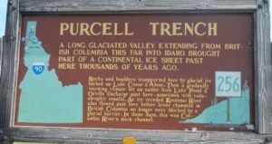
SOME LOCAL NORTHERN IDAHO ICE AGE FLOODS and GLACIAL FEATURES Purcell Trench – This structurally formed valley became the passageway for the

Ice Age Floods Fourth Grade Curriculum Development One of the missions of the Ice Age Floods Institute is to educate

Our chapter grew out of several locals, referred to as “belt nerds,” who were mainly interested in the Belt Rocks and the Purcell Trench but who also had some peripheral interest in the Ice Age Floods. Their interests did not result in much contact with the Ice Age Floods Institute (IAFI). Fortunately for us, Julie Bishop contacted the IAFI and got the process to become a chapter underway. According to our records, Julie is the only one who has been a member of the Coeur Du Deluge Chapter since its beginning.
We were not the first IAFI Chapter established, but we were not the last. The Coeur Du Deluge Chapter was established in 2005 along with the Lower Columbia Chapter. Since then, five more chapters have been established covering the four states of Washington, Oregon, Idaho, and Montana. Our chapter was served well by our two former Presidents, Jon Burkhart and Sylvie White. Tony Lewis is our present President.
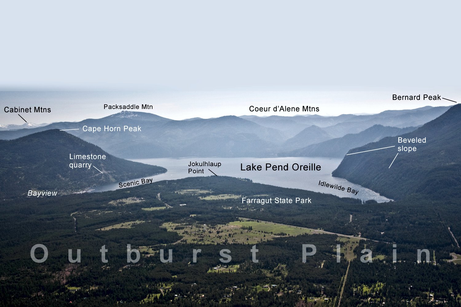
As expressed in our chapter’s name, Coeur du Deluge, our chapter is in the “Heart of the Flood!” Or as we like to say, “Where the Floods Began!” which includes the Glacial Ice Dam, the Outburst Plain and the flood deposits that make up the Rathdrum Prairie Aquifer. We are fortunate to have two state parks (Farragut SP and Round Lake SP) in our area. Both provide great examples of Ice Age Flood related features. These parks also have campgrounds and host Ice Age Floods talks and field trips.
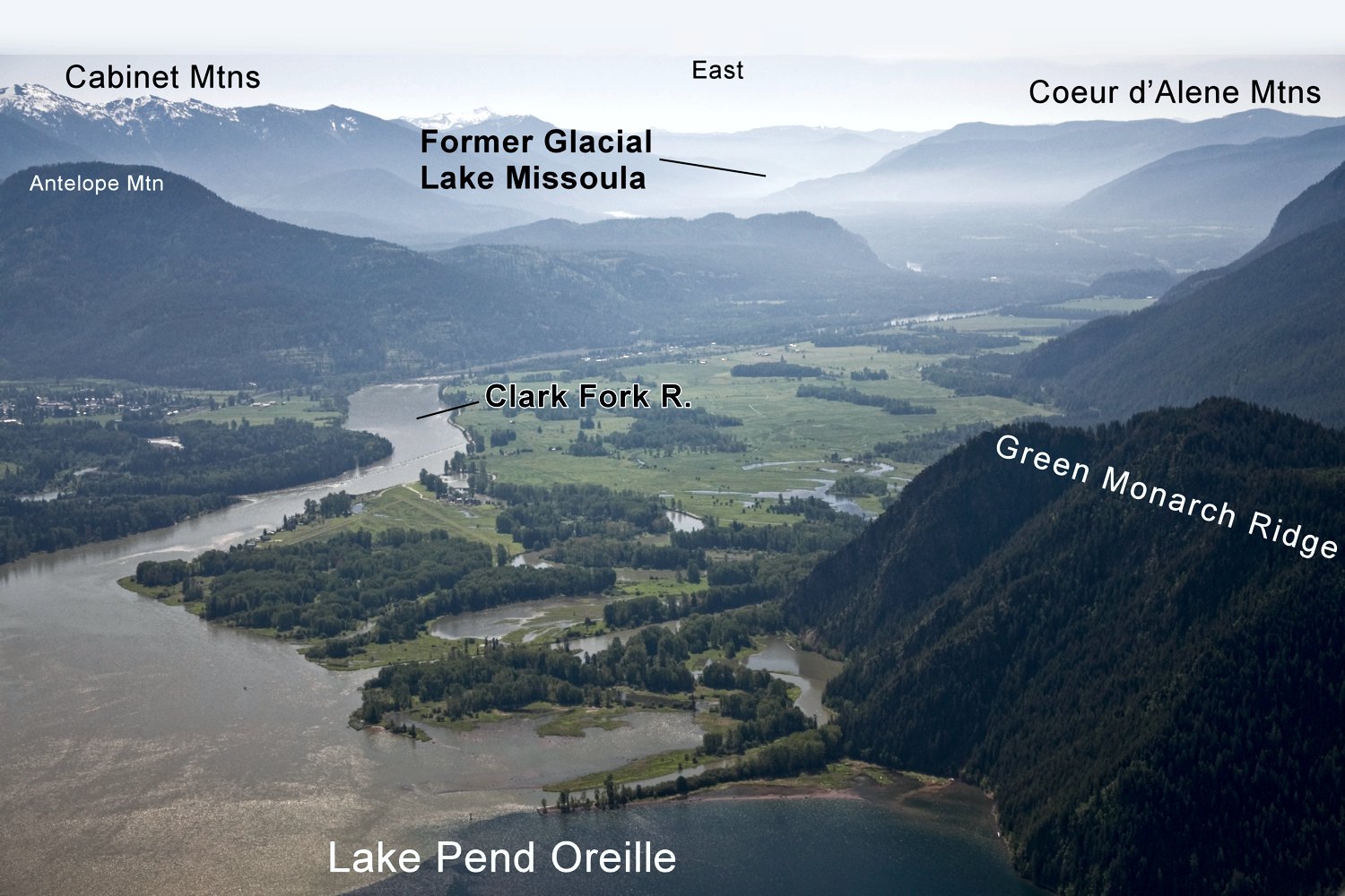
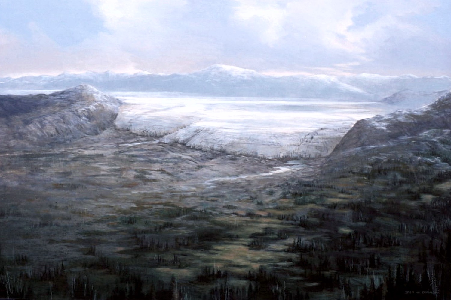
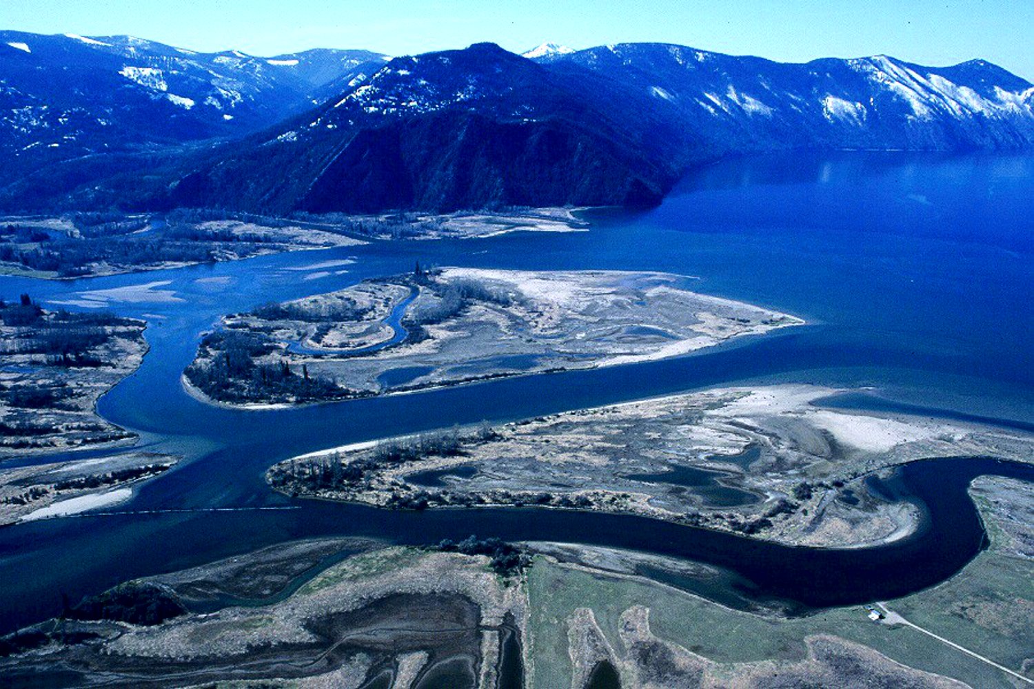
Lake Pend Oreille, the largest and deepest lake in Idaho and a major Ice Age Floods feature, is in our area of interest. When it was filled with ice up to 4,000 feet deep, it was part of the Ice Dam that helped create Glacial Lake Missoula. Lake Pend Oreille boat tours of the north shore, the shear-face of the Green Monarchs, and the Clark Fork Delta are all used to tell part of our Ice Age Floods story.
We publicize our Ice Age Floods story through indoor and outdoor public lectures, grade school presentations, field trips and, as mentioned, the occasional boat tour. Every year several IAF lectures and field trips are provided at the request of the Idaho Master Naturalist Program, the Idaho Native Plant Society and Farragut State Park.

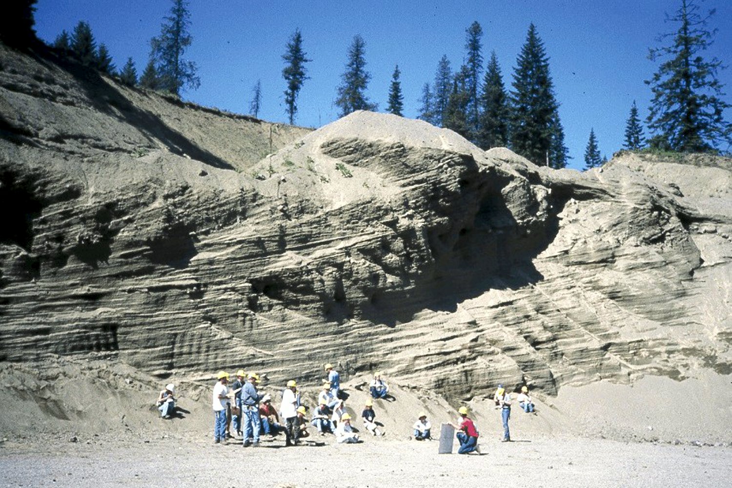
Our chapter was fortunate to have Roy Breckenridge and Dean Garwood, two excellent geologists with deep pockets of information on the Ice Age Floods, as chapter members willing to share their knowledge with us for over a decade. Roy Breckenridge, Director and State Geologist for the Idaho Geological Survey, mapped the surficial geology of most of North Idaho and was responsible for establishing the foundation for almost all of the field trips that we still take. Dean Garwood, Roy’s student and field assistant, also assisted with our field trips and, more importantly, finalized the maps that he and Roy were working on after Roy passed. More on this map is in the Special Events section.
There are many others who have supported the Coeur du Deluge Chapter over these almost 20 years of the chapter’s existence, and I would like to recognize their contributions. Of course, I will inadvertently forget some and for that I apologize. I have already acknowledged the past Presidents so on to the others that have supported our efforts to learn about and promote information about the Ice Age Floods. The one person who has been actively involved in the founding and fostering of the Coeur du Deluge Chapter since its inception is Julie Bishop. There is a good chance that without Julie’s efforts in the early founding of the chapter and her continued involvement there would be no Coeur du Deluge Chapter. I have been fortunate to work with her for about 10 years and know that she has made my job a lot easier and continues to serve as our chapter’s Treasurer. Nancy Low managed the Store in a Box for our chapter for over a decade and is still an active member. Other noted supporters and longtime members are Carol and Irv Jenkins, Keokee Company and Publishing Inc., Harry Menser, Nancy and Tom Renk, Patrick Meyers, Ron Mamajek and Denise Zembryki, Neil and Ann Wimberley and Selma Bair. An extra donation from Shell Oil Company is received through Irv Jenkins’ efforts. Thanks to all of you for your continued support.
Special Events

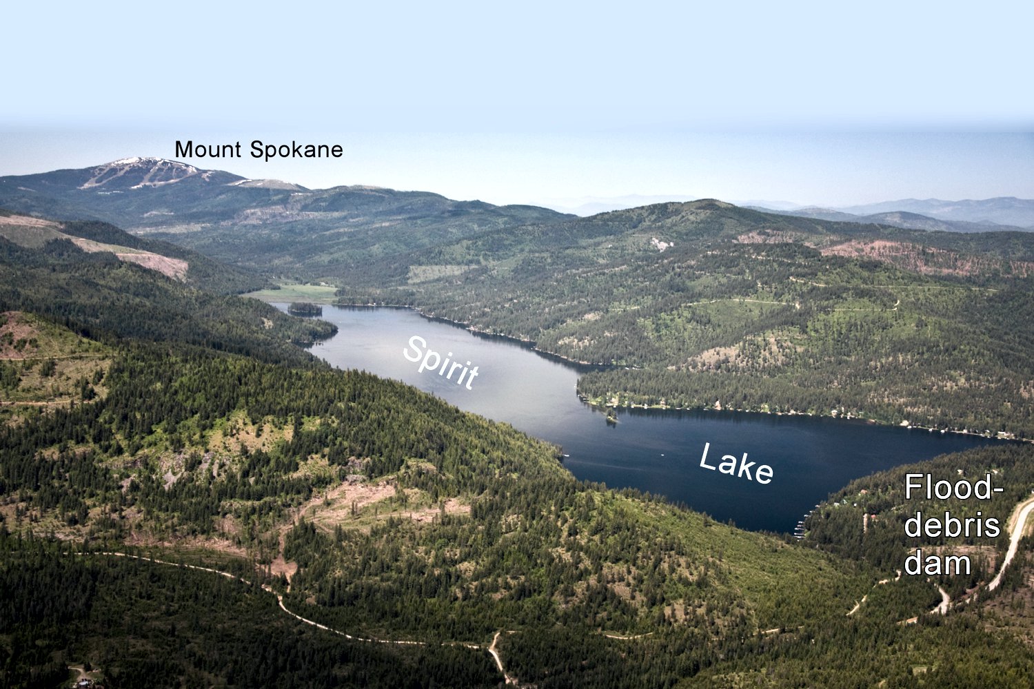
Two Special Events come to mind. The first was in 2013, when our chapter hosted the annual meeting of the Ice Age Floods Institute. Roy Breckenridge was the main organizer and leader of our field trips, along with Jack Nisbet and Dean Garwood. It was our chapter’s chance to “expose” our Ice Age Floods landscape to others in the Pacific Northwest, and it was a resounding success. The one-day field trip covered most of North Idaho from the ID/MT border to Sandpoint, ID and then south to Farragut State Park and on to Spirit Lake. This has become the cornerstone for many of our chapter’s subsequent field trips. Roy and Dean provided in-depth knowledge of the physical landscape, whereas Jack provided depth and breadth of information on the historical and cultural landscape of the region.
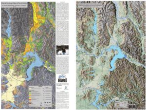 The second Special Event was the publication of a two-sided approximately 2 ft. by 3 ft. full color map. This two-sided map includes a map titled Glacial Geologic Map of North Idaho on the front and Shaded Relief Map of Northern Idaho and parts of Western Montana and Eastern Washington on the back side. The Glacial Geologic Map of North Idaho represents over 30 years of research and field work by Dr. Roy Breckenridge, former Idaho State Geologist. The second author of this map is Dean Garwood, who following Roy’s passing organized Roy’s information and using his GIS skills put together multiple layers of information to produce the final map. The map is in commemoration of Roy and his dedication to the fields of Geology and Education and his commitment to our chapter and the Ice Age Floods Institute. The backside of the map is a colorized shaded relief model overlain with other important geographic information created and generated by Dean Garwood.
They were both one-time events that cannot be repeated; however, we do try to mimic and expand the field trips and utilize the two-sided map to promote a better understanding of the Ice Age Floods.

 Our chapter usually organizes several field trips a year for various groups, such as elementary schools, retirement facilities, state parks and volunteer groups such as the Native Plant Society and the Idaho Master Naturalist Program. Usually, the field trips are preceded by an earlier lecture on the Ice Age Floods and their impact on North Idaho topped by the fact that Sandpoint, Coeur d’Alene and many other physical and cultural features we take for granted would not exist if the Ice Age Floods had not happened. In addition to all the cities and towns that owe their existence to the Ice Age Floods and their deposits, think of the many lakes (Lake Pend Oreille, Lake Coeur d’Alene and others) along with the ground water resource that support the outdoor recreation activities, industry and population in the Rathdrum Prairie/Spokane Valley.
Along with the field trips by car and bus we have organized and/or assisted other groups in putting on Field Trips by Boat! Weather permitting, these trips always turn out to be a success. The trips usually cruise along the north shore of Lake Pend Oreille, past Hope and up the Clark Fork River Delta. Then if pre-arranged, the tour boat travels along the face of the Green Monarchs where the southward moving glacier from the Purcell Trench would have crashed against and grinding into the massive Green Monarchs. Upon being impeded by the Green Monarch the Purcell Trench Glacial Lobe, several sublobes formed. One sublobe pushed eastward forming the ice plug that blocked the Clark Fork River. Another sublobe moved southward filling the valley now occupied by Lake Pend Oreille with glacial ice and eventually covering most of what is now Farragut State Park. Major transportation arteries moving through Sandpoint are largely located where the glacial lobes and sublobes were located. It is a great educational tour.
My First Interaction with a Local Ice Age Floods Enthusiast
The Coeur du Deluge Chapter of the Ice Age Floods Institute is perhaps the smallest of the IAFI chapters. We are located in a rural but exceptionally scenic location and as stated earlier, it is where the Floods began. Which reminds me of a story. Long ago when I began my tenure as Chapter President, I was interviewed by Dave Gunter for the local paper, The Daily Bee. Dave did a great job of interviewing and writing up the story of the Ice Age Floods. However, when I read his article, I immediately knew that I was in trouble because he correctly quoted me as saying “I love living right where the floods started!” And I was sure someone would question the audacity of my statement since I lived on Sagle Peninsula, over 40 miles by car from the mouth of the Clark Fork River. The article was printed on Sunday and on Monday I got a phone call. It was from a ninety-some year-old lady named Mary McFarland who lived on the Clark Fork River a couple miles from the mouth of the Clark Fork River delta. She asked me where I lived, and I told her. She then told me in no such words that I did NOT live where the floods started, but she did! She then told me that her father knew J Harlan Bretz, and when she was 10 years old she was in the field with her father and Bretz. She then told me about all the literature she had on the Ice Age Floods. I responded that she must know more about the floods than I did to which she responded, “Yes, I do!” I immediately knew that I liked this lady and later got to visit with her several times at her home “right where the Ice Age Floods started.”
This document was authored by Tony Lewis with assistance from Julie Bishop. Tony Lewis is responsible for all the grammar and factual mistakes.