New – Lower Columbia Chapter Brochure
The Lower Columbia Chapter of IAFI recently produced the third IAFI chapter-specific “Our Cataclysmic Floodscapes” brochure, a guide to several of the key Ice Age Floods sites in the Portland Basin. This multi-panel brochure includes brief descriptions and map locations for five key sites, The Story of the Great Floods, Interesting Flood Facts, information about the Lower Columbia Chapter, and more. Expanded out the brochure measures 18″x23″, but it is folded to a rack card size for distribution to visitor centers. Click here to view a PDF of the brochure, and for more information about where a brochure can be obtained please contact Rick Thompson, President of the Lower Columbia Chapter (Rick@GigaFlood.com).
2018 Annual IAFI Field Trip – Lower Columbia Chapter
We started our field trip at the Tualatin library where the bones of a number of ice age mega-fauna are on display. Yvonne Addington led us through the displays and explained some of her role in arranging to have the bones in Tualatin where they were found. After the library we took a stroll on the Tualatin River Greenway Trail where we were instructed by several members of the Rivers of Life Youth Tourism Corp. who volunteered to be docents on the trail. We viewed signs, erratic boulders, casts of the mega-fauna and granite insets with maps and timelines. This $3.8 million trail was put in a couple years ago as part of Tualatin’s ice age identity as well as the $230,000 bronze statue of a young mastodon and a stylized image of the boy who dug it up only about a mile from where the bronze is today. Most of the actual skeleton of the mastodon is now on display in the library. After viewing the statue we went to the neighboring town of West Linn. At Fields Bridge Park we walked the nature trail with its three kiosks revealing the story of the ice age floods and the Willamette Meteorite that landed not far from there when the iceberg it was carried in was grounded on the hillside. From Fields Bridge Park we traveled east on Willamette Falls Drive over the gravel bar that the town of Willamette was built on. We then stopped at the I-205 overlook to see Willamette Falls. This Falls is the second largest in the United States by volume after Niagara Falls. Since this has been a fairly dry year it was easy to see the basalt rocks that the river cascades over. After lunch at Tualatin Community Park we took a short drive to the Tualatin Heritage Center; home of the Tualatin History Society. It is here where the molar and tusk from the Tualatin mastodon is housed as well as a collection of ice rafted boulders from the surrounding area. Yvonne Addington, former president of the Tualatin Historical Society, described the display of news articles, photographs and book covers telling the story of the Center and the ice age features. Our next stop, the Tualatin Commons, has a man-made lake with undulating hand-railing representing the wave action of the Ice Age floods and glass drinking fountains representing icebergs in those floods along with several ice rafted boulders; one being an argillite. Partly for fun and partly to see how a community can capitalize on an ice age idea we went to Ibach Park with its symbolic ice age floods play structures. The spongy blue pavement represented the water; some of it including ripples with icebergs. In the sand area children can dig for replica fossils and with the water feature they are able to make their own ice age floods through a collection of ice rafted erratics. We viewed the sign that for the last 20 years has been telling people about the ice age floods, the Willamette Meteorite, the mastodon and the local history. This award-winning park and its structures and signage was years ahead of other areas in adopting the ice age floods theme. Click here to view the full article with many more pictures. Between the towns of Tualatin and Sherwood there is a series of ice age flood channels that funneled the water from the Tualatin Valley into the Willamette Valley. This area is called the Tonquin Scablands. We stopped to view an erosional remnant of two basalt flows separated by a soil horizon and Coffee Lake, a kolk lake, created when two flood channels converged and formed a vortex that removed rock and soil leaving what is now a coffee-colored lake. We then drove along the largest of the 14 Tonquin Flood Channels to an area where we could get out and view that channel both north and south.
Boulderstrewn – Bretz’s Historical Home
“Boulderstrewn” is the home J Harlen Bretz built in the Chicago suburbs in the 1920’s and died in on his 98th birthday. Much of Bretz is still there, and since purchasing Boulderstrewn over 10 years ago the current owner has toiled to resurrect Bretz’s presence on the property. The owner created a rock garden of many specimens that remain on the property, which had been slowly getting buried. Many monuments Bretz built are still there – a travertine bird bath, a sandstone sundial and a concretion on a pedestal. Inside the house, besides an updated kitchen, it’s very much the same as during the time of Bretz and Fanny. The basement features Bretz’s still usable cold shower (no hot water just as Bretz liked it) and soap dish (though someone painted the shower white). Bretz’ secret wine cellar room is also still there, though the gate and intricate lock system is gone. Little remnants of his boobytraps are everywhere, as well as old bottles from his winemaking days and a few license plates. The Garden Cabin with a beautiful stone fireplace he built in the back of the yard for Fanny to do her art is still there, recently fully restored and rescued from sinking into the ground. As you can see in the photos on the AirBnB site the property appears to be in impeccable shape. The current owner, Peter Doran, no longer lives in the area and is unable to continue supporting the house expenses. So he is considering options from AirBnB to selling the property, and is receptive to interest and other suggestions. If anyone has, or knows of someone who has an interest in or ideas for preserving this bit of Bretz’s historical legacy please get in touch with him at peter.t.doran@gmail.com.
Ice Age Floods: A Journey of Awakening – Susan Langsley
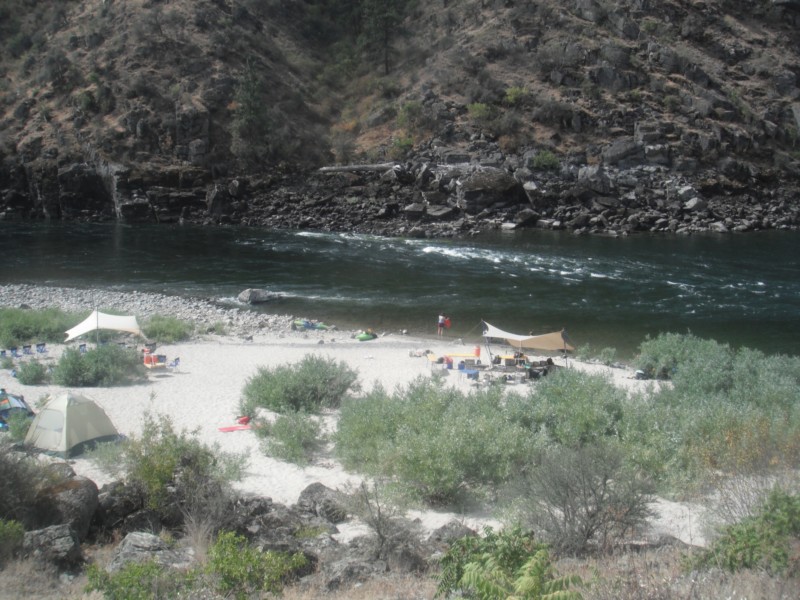
Do you ever hear the Led Zepplin song “Kashmir” in your head when contemplating the Ice Age Floods? “I am a traveler of both time and space. To be where I have been” –Robert Plant, Led Zepplin’s Kashmir My 11-year old daughter and I are on a 5-day, 4-night raft trip on the Lower Salmon river and we are having the time of our lives! Sun, sand, water, lovely food, games and some of the finest nicest Eastern Oregonians we have ever met. One of the guides is a sensitive and strapping young man who is a student at U of Oregon. He’s both an English major and a Geology major. What do you with that? You write about the soul of the earth, true love and adventure, river stories, deep thoughts that cross scientific paradigms. I see him becoming a teacher someday, maybe a science teacher like his Dad. And he’s a kayaker like me. What is so amazing about the Eastern Oregon guides is their familiarity with, connection to, and love of the river and land. They don’t fight traffic or get on the morning commute treadmill every day. There are no stoplights in the whole of Wallowa County, and the only food franchise is a Subway sandwich shop, no Costco or Walmart. Sure, they have school and work, but they are connected to and love the land they live on in deeper ways that us city folks miss. They are here to tell us about the land. They are guides. The 4th day on the river we pass a group of pillar-like rocks with beautiful symmetry. “That’s columnar basalt” my guide says, “The geologist who figured out the floods and travelled around these parts was J Harlan Bretz”. “J Harlan Bretz” I repeat, carefully, committing to memory. When I returned home to talk to my friend (who was a geology major at Wesleyan) about the trip, she replies “’J Harlan Bretz,’ Oh yes, I have all his books!” An Amazon search and I begin by reading a biography of J Harlan Bretz, “Bretz’s Flood” by John Soennichsen- (some guy from Eastern Washington… hmmm). And guess what: It’s so well-written, I can’t put it down! I am enthralled cover-to-cover with the character of J Harlan Bretz, his teaching method of taking students to the field (and floating them downstream on large Sequoia logs, upon occasion), his love of life, the serendipity of his study of the USGS Quincy Basin topo map when it first published, many summers spent driving around and measuring the Channeled Scablands, presenting his field evidence and theories at the Cosmos Club in Washington DC, and most of all his ability to KNOW he was RIGHT when all his colleagues scoffed and dismissed his theories. Now THAT man was a pillar of strength. Perhaps like a column of basalt? If he were alive today, Harlan Bretz could stand up to money-motivated physicians – the bad kind, nepotism in the school district, gossipers and bullies, and other types of corruption, all of which I have had to do to defend my younger child against since. J Harlan Bretz helped me to do this. He was a GREAT man! “All I see turns to brown.. And fills my eyes with sand as I try not see the wasted land” – Kashmir by Led Zepplin What was it about those floods, biblical in nature, that left behind a story of such jaw-dropping inspiration? Who are these people who live in Eastern Oregon and Washington and are so inspired by the landscapes there they are called to find new ways to study it, publish, write fantastic biographies? I continued my search to find other scholars of the Ice Age Floods, and that led me next to Nick Zentner and Bruce Bjornstadt. To be continued…
IAFI – GuideStar Bronze
Ice Age Floods Institute was recently recognized for our transparency with a 2018 Bronze Seal on our GuideStar Nonprofit Profile! GuideStar is the world’s largest source of information on nonprofit organizations. More than 8 million visitors per year and a network of 200+ partners use GuideStar data to grow support for nonprofits. In order to get the 2018 Bronze Seal, Ice Age Floods Institute shared important information with the public using our profile on GuideStar. Now our community members and potential donors can find out more about our mission and programs. Check out our GuideStar Nonprofit Profile and tell us what you think.
13,000 Year-Old Human Footprints Found on BC Island
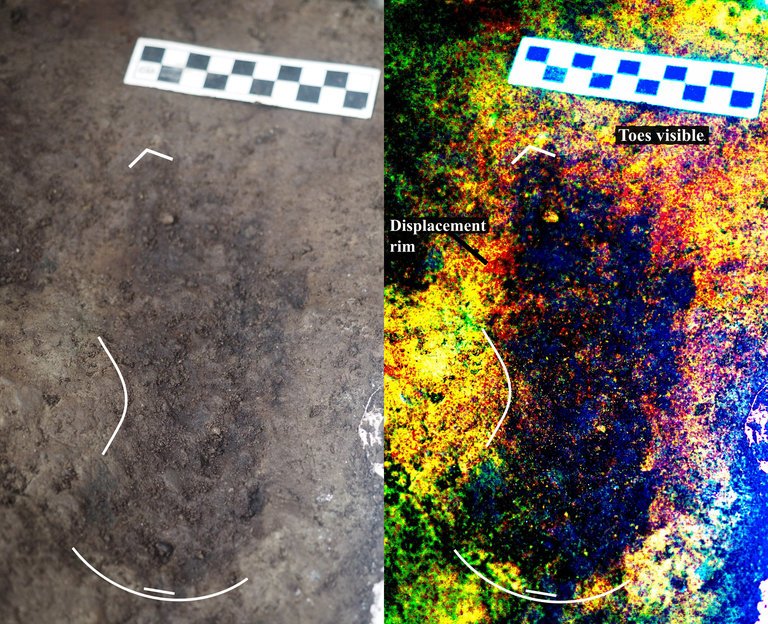
Big feet. Little feet. A heel here. A toe there. A digitally enhanced photo of a footprint found at Calvert Island, British Columbia that researchers dated to 13,000 years old. Credit Duncan McLaren Stamped across the shoreline of Calvert Island, British Columbia, are 13,000-year-old human footprints that archaeologists believe to be the earliest found so far in North America. The finding, which was published Wednesday in the journal PLOS One, adds support to the idea that some ancient humans from Asia ventured into North America by hugging the Pacific coastline, rather than by traveling through the interior. “This provides evidence that people were inhabiting the region at the end of the last ice age,” said Duncan McLaren, an anthropologist at the Hakai Institute and University of Victoria in British Columbia and lead author of the study. “It is possible that the coast was one of the means by which people entered the Americas at that time.” Dr. McLaren and his colleagues stumbled upon the footprints while digging for sediments beneath Calvert Island’s beach sands. Today, the area is covered with thick bogs and dense forests that the team, which included representatives from the Heiltsuk First Nation and Wuikinuxv First Nation, could only access by boat. At the close of the last ice age, from 11,000 to 14,000 years ago, the sea level was six to ten feet lower. The footprints were most likely left in an area that was just above the high tide line. “As this island would only have been accessible by watercraft 13,000 years ago,” Dr. McLaren said, “it implies that the people who left the footprints were seafarers who used boats to get around, gather and hunt for food and live and explore the islands.” They found their first footprint in 2014. While digging about two feet beneath the surface in a 20-square-inch hole, they saw an impression of something foot-shaped in the light brown clay. In 2015 and 2016, they returned and expanded the muddy pit. They discovered several more steps preserved in the sediment. The prints were of different sizes and pointed in different directions. Most were right feet. When the team was finished they had counted 29 in total, possibly belonging to two adults and a child. Each was barefoot. The researchers think that after the people left their footprints on the clay, their impressions were filled in by sand, thick gravel and then another layer of clay, which may have preserved them. Using radiocarbon dating on sediment from the base of some footprint impressions, as well as two pieces of preserved wood found in the first footprint, Dr. McLaren and his team found them to be 13,000 years old. That would make them the oldest preserved human footprints in North America. “It’s not only the footprints themselves that are spectacular and so rare in archaeological context, but also the age of the site,” said Michael Petraglia, an archaeologist from the Max Planck Institute for the Science of Human History in Germany who edited the paper for PLOS One but was not involved in the work. “It suggests an early entrance into the Americas.” Dr. Petraglia said the footprints also provided strong evidence for the coastal movement hypothesis and he added that they may have traveled the so-called “Kelp Highway,” a hypothesis that underwater kelp forests supported ecosystems down the North Pacific coast that helped ancient seafaring people hunt, develop and migrate. “The work is important because it shows the ‘real’ people, not just artifacts or skeletal remains,” said Steve Webb, a biological archaeologist at Bond University in Australia. “However, the footprints are limited in number and don’t shed light on activities or movement that tell us very much.” He added that future hunts for footprints should keep in mind that not everyone from this time period walked around barefoot. If anthropologists are too busy searching for soles, toes and arches, they might miss clues from those who wore animal skin shoes. Reprinted from New York Times – Earliest Known Human Footprints in North America Found on Canadian Island By NICHOLAS ST. FLEUR, March 28, 2018
ESA Maps a Lava Tube for Moon and Mars Expeditions

With all deference to the book and movie “The Martian”, wouldn’t you, as part of an interplanetary expedition, prefer to be protected from the radiation, micro-meteorites and extreme temperature fluctuations of the Moon or Martian surface? Though some of the hazards depicted in “The Martian” are way over-dramatized (the thin Martian atmosphere wouldn’t sustain the depicted raging storms), there are still hazards aplenty on the surface. So why not site your habitat in a cozy lava tube, protected from many of those surface nasties. At least that’s some of the reasoning behind a European Space Agency (ESA) effort to map a portion of Spanish lava tube in centimeter-scale detail as part of the ESA’s 2017 Pangaea-X campaign. Some chambers in the 8 km long La Cueva de los Verdes lava tube are large enough to hold residential streets and houses (or a prototype Martian research station/habitat). In less than 3 hours the cave research team mapped the lava tube using the smallest and lightest imaging scanner on the market and a wearable backpack mapper that collects geometric data without a satellite and synchronizes images collected by five cameras and two 3D imaging laser profilers. While the data is still being analyzed, ESA has released this ghostly fly-thru of a 1.3 km portion of the lava tube. Click the play button and prepare to take a pseudo-trip to Mars. So, the next time you visit a cave or lava tube, especially a large one, imagine yourself in a spacesuit on the Moon or Mars and realize that you’re actually an inner-space explorer. But don’t be too surprised at the creatures you may run into, they’re just other inner-space explorers too.
If You Have A Story, We Want to Hear It!
Our members come from varied and interesting walks of life, yet one bond that we share is our interest in the Ice Age Floods. Whether we’re captivated by the compelling stories of the floods, or the magnificent landscapes they helped create, or wanting to understand what’s behind the land we live in, we all share this common bond. And we all have experiences, insights and passions that would also interest others who share this bond. The IAFI website and newsletter are always on the lookout for short articles and captivating images related to these experiences, insights and passions that can, and probably should be shared with others. We encourage you to occasionally take a moment to share a short ‘floods’ story about your favorite place, or something you’ve done, or even what the floods places and stories have meant to you. We also want to share news, information and stories from all our widespread chapter areas, so your contributions can help others find, experience or think about something or some place they might have not been aware of before. We’re interested in short articles, longer than a Facebook post but generally shorter than a magazine article (100-500 words), that even loosely relate to the Ice Age Floods. For example, we’ve featured articles about field excursions, special places to be visited, shared experiences, technical notes, even stories about love found through the IAFI. And don’t worry if you’re not a ‘writer’, our editors will gently mold your story to enhance and fit it to our formats. Also, since images are often worth a thousand words, we strongly encourage you to include a compelling image or two that help tell the story. Just email the story and mages to Newsletter@IAFI.org, and thank you for sharing.
What’s Beneath Our Feet?
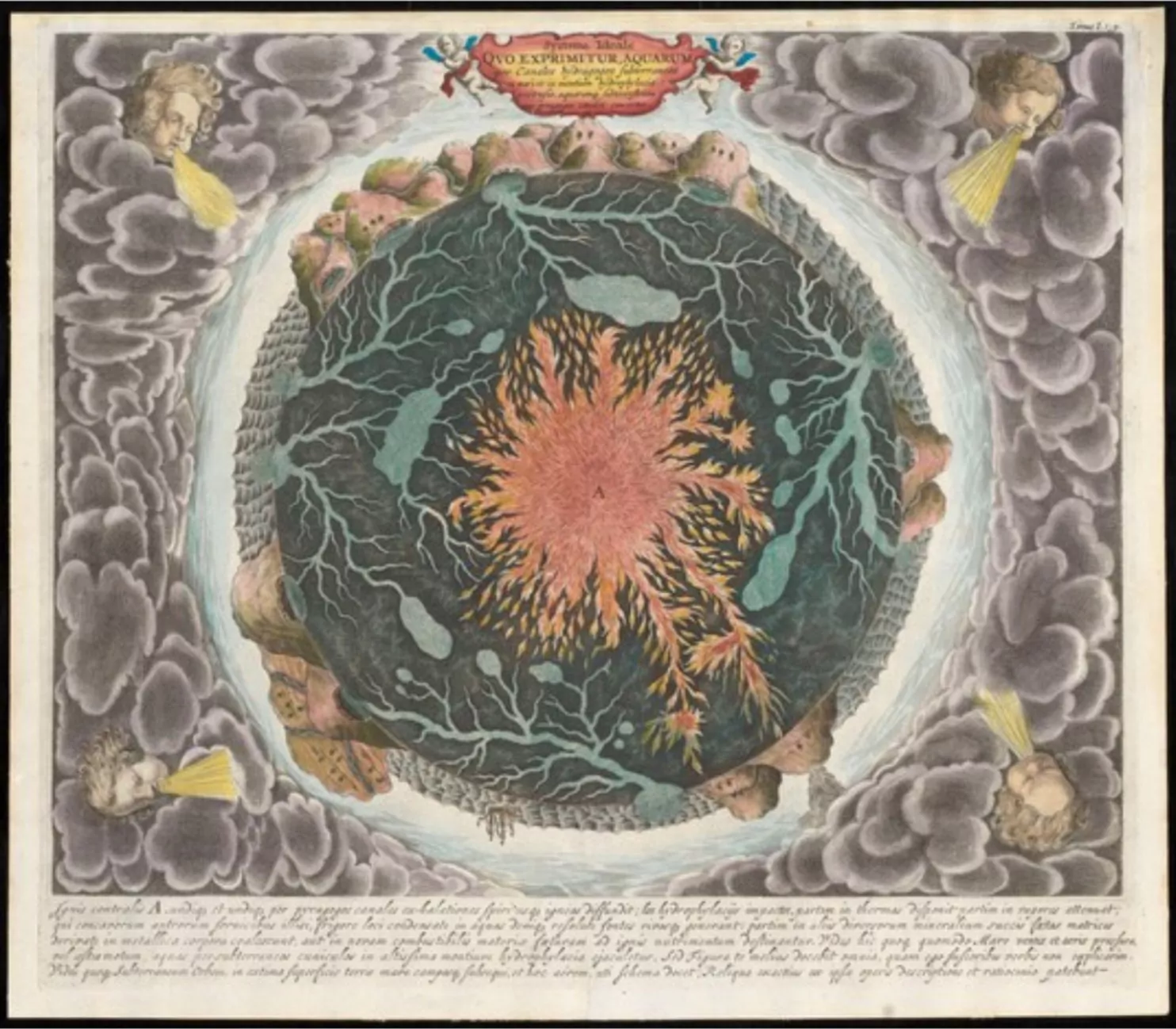
“Beneath Our Feet: Mapping the World Below” plumbs the depths of the question, “What’s beneath our feet?” through maps, images and archaeological artifacts. The exhibition explores nearly 400 years of maps and objects in an attempt to find out why and how humans imagine subterranean landscapes including caves, mines and water tables. Colorful and complicated images reflect the biases of long past and recent days and the concerns of their authors, including the United States’ desire to appropriate the natural resources of Native American lands and a 17th-century Jesuit priest’s attempt to use Scripture to create a framework for Earth’s geology. Catch the exhibition online, including a bibliography, reading lists and a 3-D tour of the Boston Public Library’s Norman B. Leventhal Map Center gallery itself. As you explore nearly 400 years of maps and images of the world below, you can compare the historical viewpoint with the modern, and see how we have advanced our perception and depiction of what lies beneath.
Share the Floods News That’s Fit to Print
Do you write and/or edit well? Do you like knowing what’s going on in your IAFI chapter? Do you think that news should be shared with others? Then we have a SMALL job for you that can be a BIG help for your chapter and for the Ice Age Floods Institute in general. Every IAFI chapter has news and events that should be shared with other chapter members and maybe other chapters. We have an active website, social media, and a newsletter to share them on. But sometimes the news and events can get skipped over when the chapter leaders get overloaded or may not be particularly comfortable with writing to inform and interest others. If you write well and can find a little time each month we will show you how you can easily help us get the word out about important news and events. As a result you’ll help your chapter grow and become more active, and you’ll be one of the first to know about news and events that are happening. If this sounds like something you can do to help your chapter, please contact your chapter president (if you’re not sure who that is, visit https://iafi.org/about-iafi/board-directory/) and we’ll get you plugged in.