Explore the Ice Age Floods with 12 New IAFI Brochures

IAFI has compiled 12 brand-new, full-color brochures into a packaged set to help guide you in visiting spectacular ice-age features across all of our 11 Ice Age Floods chapter areas. With these brochures as your guides you can explore the paths of the Ice Age Floods from Montana through Idaho, central Washington and northern Oregon, and even delve into the many glacial features of northwest Washington. Click on any of the brochure covers below to see a full size printable PDF version (note: you’ll need to scale down to print on 8.5×11 letter size paper). Packets of all 12 full-size brochures are NOW available through the IAFI Store and at participating local outlets. Click a cover to open a PDF of any of the brochures below
Become An Ice Age Floods Junior Ranger
The National Park Service has developed a new Junior Ranger Program for the Ice Age Floods National Geologic Trail. They’ve developed a Megaflood Adventure Junior Ranger Activity Book in three separate section to help guide Junior Rangers in seeing what they can find as they explore the area of the Ice Age Floods.They will be working on a reduced size version that will be fillable online, but for now the three sections that form the complete book must be downloaded and printed: Megaflood Adventure section 1 Megaflood Adventure section 2 Megaflood Adventure section 3 To receive the Junior Ranger badge when the three sections are complete, mail the booklet to: Ice Age Floods Junior Ranger 1008 Crest Drive Coulee Dam, WA 99116 They will be adding more in-person sites as the program grows. They would also love to receive feedback! Please send an email to let us know what you liked, what worked well for you, and ways that the program can be improved.
Model for a Missoula Flood
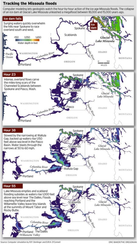
ICYMI (in case you missed it) — Floodwaters rise more than 1,000 feet as they slam into the Columbia River Gorge from the east. The torrent blasts through the narrows at 60 mph, carrying truck-size boulders and house-size icebergs. Reaching Portland, water loaded with gravel and dirt roils to a depth of 400 feet, leaving tiny islands at the summits of Mount Tabor and Rocky Butte. Geologists have spent decades piecing together evidence to tell the story of the great Missoula floods that reshaped much of Oregon and Washington between 18,000 and 15,000 years ago. Now scientists have found a way to travel back in time to watch the megafloods unfold, in a virtual bird’s eye view. Their computer simulation displays the likely timing and play-by-play action, starting with the collapse of an ice dam and outpouring of a lake 200 miles across and 2,100 feet deep. The computer model, developed by Roger Denlinger with the U.S. Geological Survey in Vancouver and Colorado-based geophysicist Daniel O’Connell, is filling gaps in scientific explanations of the floods and the baffling landforms they left, including the fabled Channeled Scablands — scars hundreds of miles long cut into the bedrock of eastern Washington and visible from outer space. The simulations also may help settle a lingering scientific controversy about what caused the repeating ice-age catastrophes. “It’s just really powerful visualization that gives a sense of the scale of the floods, how they came down through the channel system and backed up the big tributary valleys,” said Jim O’Connor, a hydrologist with the U.S. Geological Survey in Portland who has written extensively on the Missoula floods. He said the modeling work provides the first “really good information” on the timing of events. During the last ice age, a continent-spanning ice sheet built from massively expanded glaciers descended from the Canadian Rocky Mountains to reach deep into Washington, Idaho and Montana. Glacial Lake Missoula formed behind a miles-long dam of ice across what is now the valley of the Clark Fork and Pend Oreille rivers running from Montana to northeast Washington. The dam formed and collapsed dozens of times over a span of three thousand years. In the simulation of one of the largest possible floods, raging water quickly overwhelms the hills near Spokane and races overland to the south and west. The intense, overland flows carve the miles-long scars of the scablands between Spokane and Pasco, Wash. Thirty-eight hours later, swirling, mud-darkened waters converge at the narrowing of the Columbia at Wallula Gap, where the backed-up flow rises 850 feet above river level (1,150 feet above sea level). An immense volume of water blasts through the narrows at fire-hose velocity. Flow exceeds 1.3 billion gallons per second — a thousand times greater than the Columbia’s average flows today. Lake Missoula’s water, all 550 cubic miles of it, drains in 55 hours — less than three days — according to the model. At that time, the flood surge peaks in the Columbia Gorge at The Dalles, rising 950 feet above river level (1,000 feet above sea level), spilling over the gorge walls in places, and flooding the valleys of tributaries for miles upstream. Inundation of the Willamette Valley peaks on the seventh day after dam burst, in the simulation. Flooding reaches as far south as Eugene. Loaded with mud and gravel, the flood dumps sediment across the entire valley. Repeated floods build a layer 100 feet thick in Woodburn. Such a vast inundation, far greater than anything ever witnessed in historical time, seemed impossible to geologists in the 1920s, when J Harlen Bretz proposed that the scablands resulted from a catastrophic flood, not eons of gradual erosion. The idea didn’t gain mainstream acceptance until the 1960s. Since then, geologists have found evidence that Lake Missoula emptied catastrophically dozens of times during the last ice age. But controversy persists. A few scientists assert that the cataclysmic floods must have had multiple sources, not just an outburst from Lake Missoula. John Shaw of the University of Alberta in Edmonton, for instance, has proposed that an enormous reservoir beneath the ice sheet over much of central British Columbia boosted the flooding. The new simulation suggests that discharge from Lake Missoula alone would have been powerful enough. The simulated flood reaches peak stages all along its route that match the evidence visible today in sediment, with one big exception: At Wallula Gap, water levels in the simulation fell short by as much as 130 feet. “It’s pretty clear, if Lake Missoula is enough to hit all the other high water marks, you don’t need another source of water,” Denlinger said. Calculating the convoluted paths of such a massive flood requires an immense amount of number crunching. Simulating one flood requires more than 8 months of computer time, Denlinger said. But the computer simulation isn’t likely to end the debate. The fact that it can’t reproduce the maximum flooding at Wallula Gap leaves room for doubts. And some experts say there is direct evidence for an additional source of flood waters from beneath the ice sheet that covered the Okanagan Valley. “It is conceivable that other valleys in southern British Columbia contributed water to the scablands but the field evidence necessary to test these possibilities has not been fully documented,” said earth scientist Jerome-Etienne Lesemann at the University of Aarhus in Denmark. “There are a number of unanswered questions,” he said. “That makes the whole Channeled Scablands story a really interesting and intriguing geological puzzle.” Reprinted from The Oregonian, original article by Joe Rojas-Burke, 2010
11+1 New Ice Age Floods Chapter Brochures
Individualized brochures for each of the eleven IAFI chapters highlighting several local Floods features have been an Ice Age Floods Institute dream for the past several years, and we’re finally awakening from that dream. It began when the Lake Lewis Chapter produced a stunningly beautiful and informative 18″x24″, 24-panel, 6-fold brochure several years ago that highlighted five “Must See” Floodscapes in the south-central Columbia River Basin. Chapter representatives on the IAFI Board were so taken with the brochure that they all agreed each chapter should produce a similar brochure for their area. Unfortunately a major fly in the ointment was that no other chapter had the professional expertise to do the job. Rick Thompson of the Lower Columbia Chapter poured many frustrating hours over a couple of years into producing a similar brochure for his chapter. He eventually found an incredibly helpful resource in Ken Manske (NorthwestArtMall.com) who compiled Rick’s opus into printable form and got it printed. So now there were two brochures, but at such an expense in time, frustration, and cost that most other chapters were unable or unwilling to take on the task. Fortunately, Lloyd DeKay of the Columbia River Gorge Chapter was willing (or crazy enough) to take on the overall project under the guidance of Ken Manske (northwestArtMall.com). Ken offered a critical suggestion to change the format to a 12″x18″, 6-panel, industry-standard tri-fold design that would cost 60% less to print. Based on that suggestion, since last October Lloyd has used Inkscape, an open-source Adobe Illustrator-like program, with input from Ken and each chapter’s representatives, to design and compile new brochures in that format for the Columbia River Gorge, Puget Lobe, Wenatchee Valley Erratics, Glacial Lake Missoula, Palouse Falls, Cheney-Spokane, Coeur du Deluge, Ellensburg chapters and redesign the Lake Lewis and Lower Columbia brochures in the same format. Work is nearly complete on the final Lower Grand Coulee brochure. Because stocks of the general IAFInstitute 9″x12″ tri-fold were running low, that brochure has also been redesigned and printed. All 12 brochures are available individually and as a complete set. We can all learn from this exciting set of new brochures, each highlighting five or more local features, to help guide members, their visitors, and tourists in exploring the fascinating story of the Ice Age Floods all along and beyond the Ice Age Floods National Geologic Trail.
Oral/Pictorial Video History of the Palouse Area
This 1/2-hour video begins with the Ice Age Floods impact on the Palouse area, then goes on with a fascinating oral and pictorial history of the area. The video was produced by Mortimore Productions for the Whitman County Library with materials and information provided by a bevy of contributors, including several IAFI members. This is a must view if you’re planning to travel to the Palouse Falls Chapter. In this stunning video you’ll learn about the Floods impact, early settlers, mule trains, sheep herders, and so much more that will make the event ever more personal and relevant. Whitman County Library – Ice Age v06 from Mortimore Productions on Vimeo.
Why pay dues to IAFI????
Membership in IAFI did not grow last year, and more than a couple of local program participants I know do not belong. They may have personal reasons for this decision, but I decided to look at the cost/benefit for myself (disclaimer – I am not a board member). Most of the revenue of the Ice Age Floods Institute is from dues – dues that it shares 50-50 with member chapters, leaving it with a very modest $13,000 to spend. The rest of the budget is made up from a few donations (under $1000), income from sales from the store ($1500), field trips ($800), and income that is offset by expenses (such as brochures). This is not a large budget to work with. Some of the budget goes to contracted staff services, some is paid out for costs related to board meetings, and the rest goes to operating costs such as insurance and banking services. Some vital services – such as the website – are largely provided by volunteer effort. So what is the benefit of paying dues? While you do get a break on anything purchased from the IAFI bookstore, and on the cost of some field trips, many of the benefits of joining a mission driven organization are more intangible. The benefits include the continued existence of an organization to accomplish goals that you feel are important, helping you, the member, direct your volunteer activities in a way that promotes those goals; by providing a mechanism to receive grants and donations to carry out these activities; and by guiding others in a way that gets things done that couldn’t be finished by a few people working alone. The achievements of the organization as a whole are impressive – look at the “year in review” in the January 2019 Newsletter. The list includes lectures and field trips open to the public, brochures and educational materials, visits to classrooms and community organizations, the website, the newsletter, and partnerships and collaboration with related organizations. These activities are carried out primarily by local chapters and members on a volunteer basis – so a volunteer might feel his/her time is enough of a contribution, and actual membership and dues are not needed. While valuable – even critical – these activities should achieve more when carried out in a framework provided by the central organization. So when deciding whether to send in that annual check, you need to evaluate not what monetary benefits you might receive but whether your goals align with those of the central organization and whether the central organization is effective in achieving those goals. If so, get out your checkbook/credit card/cash and give generously. If not, let your board members know what should be changed to gain your support. Sherry McLaughlin – Glacial Lake Missoula Chapter
Tualatin Ice Age Foundation Established
A Tualatin, Oregon Ice Age Foundation has been established to provide educational and economic opportunities for area residents, students, businesses and visitors. Local interest in ancient ice-age animals started in the 1970s when a Portland State University college student dug up half of a mastodon skeleton in Tualatin, which now is on display at the Tualatin Library along with several other ancient animal bones from such as mammoths, giant sloth, and bison. In 2018 a Foundation board was created to guide the foundation and raise funds for the center. The board includes Portland State University Geology Professor Emeritus Scott Burns as President; Yvonne Addington, Tualatin Historical Society; Linda Moholt, Executive Director of Tualatin Chamber of Commerce; Paul Hennon, retired Tualatin Parks Director; Jerianne Thompson, Tualatin Librarian; and Rick and Sylvia Thompson of the Ice Age Floods Institute, Lower Columbia chapter. Prior to the Foundation being established, an Ice Age Heritage Tourism Plan, funded by Washington County Visitor’s Association, which contained recommendations for further development by an international consultant, Bill Baker, owner of Total Destination Management. Baker recommended a new Ice Age Interpretive Center to house more of the collections and educate residents and visitors. According to Baker, “the Tualatin area was front and center for one of the greatest natural events of the last ice advance: a series of colossal floods that roared down the Columbia Gorge and pooled in the Tualatin and Willamette Valleys between 18,000 and 15,000 years ago. The entire Tualatin area landscape was shaped by those floods.” Baker saw important economic development, jobs and educational opportunities and recommended a new Tualatin Ice Age Foundation to implement opportunities and raise funds for a Tualatin Ice Age Interpretive Center. Portland State University, the University of Oregon and the Ice Age Floods Institute, Lower Columbia chapter have, for several years, been assisting the Tualatin Historical Society in seeking the prehistory of Tualatin. The National Park Service has identified Tualatin as a key Ice Age Floods National Geologic Trail hub. The City has continued their efforts to display their ice age prehistory by the development of the Tualatin River Greeway Trail and Fred Bruning, chief executive for Center Cal shopping centers, donating to the public, a $220,000 bronze statue of the Tualatin Mastodon. To date, many ancient animal bones and huge multi-ton erratics carried here by roaring floods have been found. Private donations of bones continue to be offered as we seek funding for this unusual historical project of building our interpretive center. Tualatin invites you to come see the displays and exhibits we already have at the library, Tualatin Heritage Center, in our parks and walkways and in the future in our Ice Age Interpretitive Center. For more information on Tualatin’s ice age history go to: https://tualatinchamber.com/visitor/ice-age/.
“Gorge-ous Night Out” in Olympia
For the past four years and more, Gorge people and businesses have provided Oregon and Washington legislators and staff a casual “Gorge-ous Night Out” evening event to remind them and raise their awareness of the Columbia River Gorge. The intent of these matching events in both Salem and Olympia is not to lobby the legislators for anything in particular, but to remind them that we’re here, we’re vibrant, and we’re an economic and cultural force for both states. The IAFI Columbia River Gorge Chapter has been part of most of these events, educating the legislators about the Ice Age Floods story, and citing the economic role that Floods tourism can and does play in both local and state economies. It is somewhat surprising how few of the legislators have even visited some of the spectacular Floods sites throughout the region. So we premiered for them some of the new chapter tourism brochures we plan to release soon, and encouraged them to “get out on the road” for an awe inspiring look at the landscape and people they represent. We even agreed to requests for guided tours of Gorge geology from a couple of legislators and their staff. What better way to entertain and educate them while building a relationship that we can count on when we do need to ask them for their support.
“Hiding in Plain Sight”
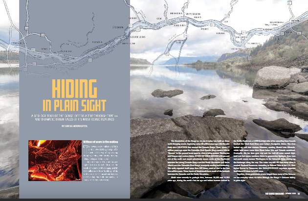
Millions of people who visit and pass through the Gorge each year don’t realize the scope of the cataclysmic stories behind the stunning and tranquil beauty they are surrounded by. The Spring 2019 edition of The Gorge Magazine (page 50) attempts to address that premise with a feature article about the geology of the Columbia River Gorge titled “Hiding in Plain Sight“. The author, Gregg Harrington, who is not a geologist, used a private tour with Lloyd DeKay, president of the Columbia River Gorge Chapter, as well as other local geologists as a basis for much of the article. The article touches on 40 million years of Gorge geology, including the Ice Age Floods, and highlights some of the more interesting geological features of this popular tourist destination. Hopefully, articles like this, along with IAFI field trips, lectures and website, will help many recognize and realize some of the tumultuous story that lies behind the enchanting scenery, and make them “never see the Gorge in the same way again”. The magazine is available online and begins at page 50. We had hoped for an Ice Age Floods Institute website mention, but a planned “For more information” section was not included in the article. Still, the article covers a lot of interesting geology of an extremely popular destination, and an article like this is a significant contribution to our efforts to inform and educate the public about the Ice Age Floods.
My Hill
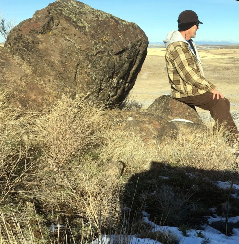
As a city kid in the ‘60s my family occasionally visited my grandparents in the farm country of Washington State’s Waterville plateau. My grandfather and two uncles were wheat farmers near the small town of Withrow, the future site of which had been partly hedged in by the Okanagan lobe of the Cordilleran Ice Sheet many thousands of years ago. Sometimes my father and I would join my uncles on the dusty 15-minute drive “out in the hills” to the sagebrush-surrounded corral, well house and large cement watering trough that served the cattle herd pastured there. Overlooking the corral was a tall hill I would sometimes climb while the trough was refilling. Warned to beware of rattlesnakes, a tiring five- or ten-minute ascent would get me to the top. Astride a large boulder, I would survey the corral far below, the sound of the pump engine distantly laboring. Around me was a panorama of other hills, about whose origins it had never occurred to me to wonder. “My hill” was steep enough that even oblong rocks I tossed down its flank would often bounce and roll clear to the bottom. On occasion, this would elicit salty, muffled hollering from Dad to cease and desist. I’m a half-century older, now, but I wish I had then understood the remarkable history of my hill. How would it have felt at that young age to know that a vast ice sheet had blanketed this terrain some 12,000 years earlier and that the hill I stood on had been its progeny? That, as that glacier began to melt, streams and rivulets had formed on its immense surface? That small sinkholes and other weaknesses in the rotting ice had allowed those waters to sculpt caverns inside the glacier? That those waters carried copious quantities of sediment and rock debris captured as the glacier eroded its way hundreds of miles southward? That my hill, like an embryo within an icy womb, had begun to grow inside one of those expanding interior caverns, ultimately to be deposited on solid ground as a kame, a lasting testament to the retreating glacier? Would I have deduced that the glacier had been at least as thick upon the land as my kame was high above the corral below me? That the erratic boulder on which I sat had been deposited on that kame like a cherry atop a geological sundae? I formed an early affection for the Withrow country because of the many relatives who, not so long ago, had peopled that farmland. It’s strange to contemplate that they are mostly gone from this land now, making it seem somewhat alien to me for their absence. And yet that hill remains, a mute sentinel having witnessed the glacier that birthed it, the quiet passage of the millennia, grandpa’s construction of that watering trough in 1948, and the naive delight of a young city kid climbing its flanks in the 1960s. Dan Jordan – IAFI Wenatchee Erratics Chapter