Fueling Yellowstone’s Supervolcano: A New Tectonic Twist
New research suggests that the Yellowstone supervolcano may not be fueled by a deep “mantle plume” as previously believed. Instead, a study published in Science suggests that the volcano’s activity is driven primarily by tectonic shifts within Earth’s crust. The New “Plumbing” Model For years, scientists debated whether Yellowstone was heated by a deep column of hot rock rising from the Earth’s core. However, researchers using 3D modeling discovered that the magma system is actually controlled by two competing tectonic forces: Crustal Stretching: The lithosphere (outer crust) is being pulled toward the U.S. West Coast. Sinking Plates: An ancient tectonic plate, the Farallon slab, is sinking beneath North America, dragging the lower crust downward. This “tug-of-war” pulls the lithosphere open, allowing magma to migrate from the southwest to the northeast and rise toward the surface. This discovery is a game-changer for volcanic forecasting. By understanding that tectonics—rather than a deep plume—fuel the system, scientists can better predict how the volcano will behave as it moves toward the thicker, colder crust to the east. “Our work changes the understanding of how the magma plumbing system works, so future eruption models have to take this into account.” — Lijun Liu, Geologist at the Chinese Academy of Sciences. This tectonic modeling isn’t just for Yellowstone. It could help researchers better understand other high-hazard systems, such as Toba in Southeast Asia and Taupo in New Zealand, potentially improving volcanic safety worldwide. From an article in LIve Science by Sarah Wild
Ice Age Floods National Geologic Trail Update – April 2026
Hello from the Trail. Spring is bringing renewed energy across the Ice Age Floods National Geologic Trail, and I am pleased to share several updates on ongoing work and collaborations that continue to strengthen how we tell the floods story with our partners. Trail Brochures Heading Out Across the Region The National Park Service recently placed an order with the Government Publishing Office for a new printing of Trail brochures. A total of 21,600 brochures will be distributed to twenty-eight partner organizations across the four-state region. These partners play an essential role in delivering high-quality flood information into the hands of visitors, educators, and residents who want to explore this remarkable landscape. Supporting Long-Range Planning for the Trail Work is underway with planning staff from the Pacific West Regional Office and the Denver Service Center on a Preliminary Planning Project. This early planning effort will allow the National Park Service to begin shaping a more comprehensive management approach for the Trail and ensure that long-term needs and partner expectations are built into future planning conversations. Teacher Workshops and Educational Partnerships The National Park Service is proud to continue partnering with the Education Committee of the Ice Age Floods Institute. The Institute has taken the lead in organizing teacher-training workshops, developing a new fourth-grade curriculum, and launching a grants program to help school districts adopt it. The Institute’s leadership on these efforts is making a measurable difference in how young learners across the region are introduced to the Ice Age floods. New Interpretive Animation The NPS Ice Age floods animation released in January brought a new tool to communities, educators, and interpreters, and we are already hearing excellent feedback. Many partners have found creative ways to use the animation in public programs, museum settings, classrooms, and community presentations. I want to extend sincere thanks to the members of the Ice Age Floods Institute for their support throughout the development of this tool. Its value is clearly demonstrated by how widely and enthusiastically it is being used. Exploring New Technology for Interpretation and Data Sharing The Trail is in the early planning stages of two technology-focused efforts with the National Park Service: Natural Resource Stewardship and Science, Inventory and Monitoring Program. The first is a potential condition assessment to help the Trail better understand the state of key flood features. The second is an exploratory effort to determine whether AI-generated three-dimensional mapping could improve how geologic information is organized and shared. At the Institute’s most recent board meeting, I presented work from Terrain 360 to help illustrate what innovative visualization tools can offer. We will continue to coordinate discussions among subject matter experts and content developers to explore new ways to organize and present data, information, and interpretation related to the Trail. Thank you to the Institute’s members, volunteers, and partners for your continued dedication to the story of the Ice Age floods. I look forward to seeing many of you out on the Trail in the months ahead. Justin Radford National Park Service Ice Age Floods National Geologic Trail
A Landscape of Transitions

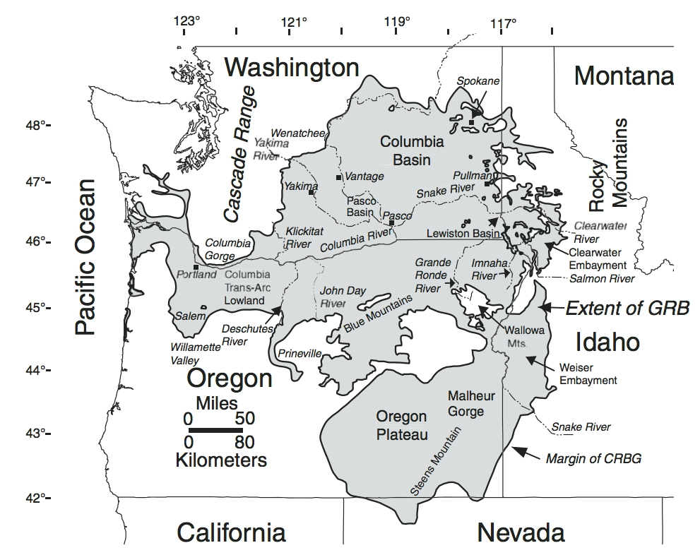
On a cool morning in late March 2026, a group of 16 curious field trip participants stood atop a scenic viewpoint in Richland, Washington looking out over the Pasco Basin, with the Yakima and Columbia Rivers silently flowing below. George Last, a local geologist and field trip leader for the Lake Lewis Chapter of the Ice Age Floods Institute, was explaining a sequence of geologic events that shaped the region surrounding the Tri-Cities. Massive lava flows filled the Columbia Basin with layers of basalt thousands of feet thick. The successive flows combined with tectonic forces uplifted and formed the anticlines along the local section of the Olympic-Wallowa Lineament – on clear display here as a chain of large rolling hills stretching from Rattlesnake Mountain to our northwest to the Horse Heaven Hills southeast of our vantage point. Ancestral rivers, responding to the changes in topography, changed courses across the landscape, cutting new routes towards the Pacific Ocean. Finally, a series of cataclysmic ice age floods roared in from its northerly source, backing up behind the natural constriction of Wallula Gap to form temporary Lake Lewis. The hilltop we occupied would have been completely overtopped by over 400 feet of debris-laden floodwaters. As we looked out onto this geologic foundation, a different landscape emerged in every direction. Our hilltop is capped by a community park. Below us, and along the hillsides of the looming anticlines nearby, the shrub-steppe slopes are blanketed with view-lot homes. Spreading out all around us is a fabric of roadways, housing developments, and commercial and industrial zones. Stretching out to the horizon are the irrigated fields, vineyards and orchards that have been an economic staple of the region since the early days of frontier settlement. Throughout the remainder of our field trip, this juxtaposition of human settlement and natural history is ever-present. A vacant lot, surrounded on three sides by a housing development, hosts an outcrop of the Ringold formation, deposited from the ancestral Columbia River or its tributaries between 3.4 and 8.5 million years ago. An 8.5 million year old basalt flow and Ice Age flood deposits ranging from 780,000 to 220,000 years old lay exposed at various abandoned quarries and borrow pits along our route. Unfortunately, several Ice Age Floods features, previously accessible, are now sequestered behind no trespassing signs or have been lost entirely to new construction. Many participants share stories of excavators uncovering a behemoth of a glacial erratic, to be methodically broken down by hydraulic hammer and hauled away to parts unknown. The final stop on the tour was the Coyote Canyon Mammoth Site outside Kennewick, operated by the MCBONES Research Center Foundation. The site is an active paleontology dig of a Columbian Mammoth, buried in late Pleistocene Ice Age flood deposits and loess. While our guide explains the methodical process of documenting each discovery, tour participants gaze upon a half-buried mammoth bone. One day this fragment will be fully exhumed after resting high in the hills for 17,500 years. It is interesting to think that, like those long buried erratics, this nearly complete skeleton may never have been discovered if not for someone searching with a shovel. It is stories like MCBONES that remind us that amid all of the re-grading, paving, and backfilling, there are stories of discovery and preservation to be shared as well. Conservation and education organizations, in the Tri-Cities and other communities across the Ice Age Floods National Geologic Trail, work tirelessly to preserve natural areas, establish trail networks, and erect educational markers calling attention to the wide variety of plants, animals and geologic features across the landscape. As development continues to expand across this region, the challenge lies in recognizing that the ground beneath our feet is not just a foundation for homes and infrastructure, but a record of deep geologic time and discovery. By fostering a balance between growth and preservation, and by supporting education, research, and access to these remarkable features, we ensure that the stories written in stone–from ancient lava flows to Ice Age floods–remain visible, accessible, and meaningful for generations to come. By John Young, Lake Lewis Chapter of Ice Age Floods Institute
Ice Age Floods Detectives – The Dalles Workshop Report
Every student in the Northwest should experience the incredible science story of the megafloods that shaped our landscape and history. To help bring this story to life, the Ice Age Floods Institute, Engaging Every Student, and our partners are excited to invite K–12 educators to free special training events. Thanks to support from the Avista Foundation, we are offering free hybrid workshops where you will gain access to valuable resources designed to inspire students to investigate their local environment.
Missoula Floods Feature – A Site of Mammoth Proportions
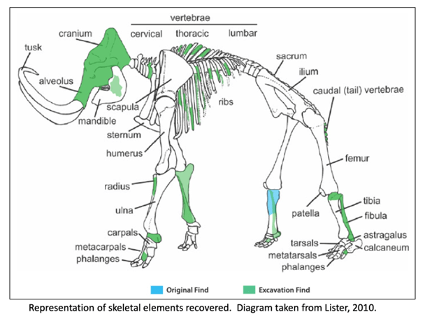
It has been well proven that the Missoula Floods greatly impacted central Washington and there are many examples of the magnitude of the floods, its reach, and dynamics. However, there is still debate on the number, size and timing and dating of these events. What is also less well known are some of the casualties of the floods. At least one feature is helping to tell the story of some of the last floods to grace the landscape. In 2015, a mammoth was discovered at Tonnemaker Hill Farm along the north edge of the Frenchman Hills in Grant County, Washington. Luke Tonnemaker was plowing up an alfalfa field when he made the discovery. Intensive study of the site was led by geologist George Last, paleontologist Bax Barton, local soil scientist and geologist Mark Amara, Gary Kleinknecht, education director, from the MCBONES Research Foundation, a volunteer excavation crew from MCBONES and the Tonnemaker family. The researchers coordinated with farm co-owners, Luke and his father, Kole Tonnemaker, and their wives Amanda and Sonia respectively, to professionally excavate, stabilize retrieved mammoth bones, identify as many bones as possible, and recreate the geology and history of the site. Mammoth remains are not that uncommon in Washington with several hundred animals discovered in the state, though fewer than 100 of those discoveries are located in eastern Washington. What is significant about this mammoth site is that it is one of the few finds that has received this much intensive study. Over 130 bones and bone fragments from a single Columbia mammoth were recovered with about 69 specimens identified. The animal was estimated to be between 25-30 years of age based on characteristics of its dentition, and it even lived with a damaged rib which had healed. George Last prepared diagram The presence of three distinct volcanic ash (tephra) layers and soil analyses suggests that at least four different Missoula flood event episodes are represented in the sediments beneath the mammoth bone bed. Dating of the site revealed that the animal post-dated identified Mount St Helens tephra eruptions that deposited ash in distinct horizons below the bones in water borne deposits. Dates associated with ash samples identified at WSU confirmed two of the layers correspond to Mount St. Helens S series while the topmost tephra shows some compositional variability but had similarities to the J or S series. Tephra ages ranged roughly from 14,000-16.000 years ago. Further dating through Utah State University was provided by optically stimulated luminescence (OSL) samples which gave dates ranging from 16-19,000 years ago. Since the bones are above the highest tephra and OSL sampling sites, the find is definitely younger than 16,000 years ago and was on the edge of one of last Pleistocene Missoula floods slack water lakes to cover this part of Washington. These conclusions were corroborated by analyzing the stratigraphy of the site and describing the soil which confirmed environments of deposition. Since the bones were above the aforementioned tephra layers and OSL sampling locations, and are at the interface of apparent windblown silts and Missoula floods slackwater deposits, it is still unclear how and when the animal died. However, the co-location of the mammoth remains with apparent ice-rafted erratic cobbles and boulders in fine-grained Missoula flood sediments, supports interpretation that the mammoth could have been carried in and left behind by a late breaking Missoula flood. Alternatively, it could have become mired in the mud along the shoreline and/or was killed by predators or even died in a subsequent drier period. Still the intensive studies to date have shown that this is an area with unique geologic history, one that is still unfolding. The Tonnemaker family has the recovered bones on display at their farm store and annually, including 2026, hold tours of the mammoth site during the Othello Sandhill Crane Festival held in March each year. There are a variety of papers, poster presentations and articles published or defended at meetings held by the Northwest Scientific Association and Geological Society of America, and a final report of findings between 2016-2024, with summaries highlighted, is available for viewing at the farm. Article by Mark Amara, Geologist, IAFI Lower Grand Coulee Chapter
A Drone’s Eye View of the Channeled Scablands
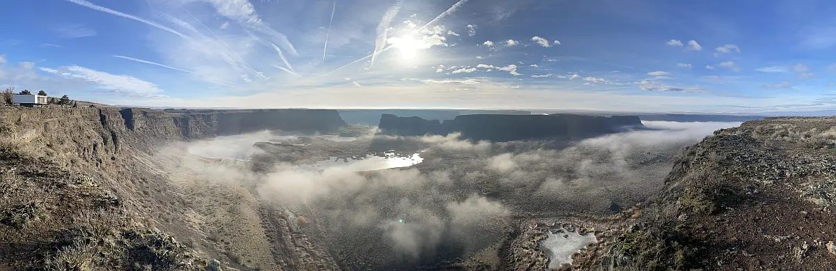
Without aerial views of the Ice Age Flood lands, we would still be debating the origins and nature of these features. Satellite and aircraft photos provide a broad overview of the channeled scablands, but in recent years, drones have given us a low-cost tool for close-up aerial photography. The detailed close-up view of the scablands showcases not only the region’s geology but also its incredible beauty. When I first saw Twin Lakes at sunrise, with the ethereal sight of fog rising from the lakes, I realized drones can help bring the scablands to the public. The dry cataracts at Potholes Coulee are another stunning feature not visible from the Ancient Lakes Trailhead but accessible by small aircraft. The trailhead is a popular starting point for exploring the coulee, with a rugged trail leading to the remnant cataracts that overlook the Columbia River. When the drone turned around and the dry falls came into view, I was awed by the cliffs towering over Babcock Bench. The photos tell a story of raging floods and giant waterfalls that have been silent for thousands of years. Lakeview Ranch (North of Odessa, WA) tells another story. The floodwaters flowing down Lake Creek Coulee spread out in this area, carving a random, chaotic landscape as they entered Crab Creek near Odessa. Bob’s Lakes, central to this area of chaos, are a central feature of this terrain, and the surrounding buttes and cliffs stand as a testament to the flood. A short distance to the northeast of Lakeview Ranch (on state road 21) is an excellent collection of structures called kolks, also called potholes. These are circular depressions drilled out by vortices in the flood waters and are not obvious from the road. All of these channeled scabland features are paradoxically difficult to see from ground level! The first time I flew a drone over Coffeepot Lake, part of the Lake Creek coulee system, the flood channels feeding into the lake became immediately obvious! Another paradox is that extremely high-altitude photos, such as those from satellites or high-altitude aircraft, make finer landscape features less obvious or even invisible. Low-flying aircraft, such as helicopters, are a possibility, but are costly to operate. Drones strike the middle ground with affordability and reasonable photographic scale. Unmanned aircraft have been flying since World War II, but with the mass production of powerful batteries, motors, and microprocessors, the aircraft’s reliability, size, and cost have become accessible to the average person. More Details About Drones Drones put high-quality flying cameras in the hands of geologists and others interested in geology. A drone, also known as an Unmanned Aerial Vehicle (UAV), is controlled by a pilot on the ground using a radio control system. The drone uses a high-quality camera to take images. So what can all of this fancy technology do? Many things! Search and rescue, mapping, power line inspections, and motion pictures are common uses for UAVs. They provide access to geologic features that are inaccessible or too dangerous for direct inspection. This access is a huge win for people studying the Ice Age Floods! A drone can photograph a coulee from its bottom to the top of the canyon rim. It can also reveal ripple marks left behind by the flood waters; marks that are invisible at ground level! Using the drone as a video camera enables real-time flight down a flood channel, giving viewers a sense of the flood. The price of these flying cameras has dropped significantly over the years. An inexpensive beginner drone with a quality camera starts at under $400. It is also under the FAA (Federal Aviation Administration) limit of 249 grams, so it doesn’t require registration. If the drone exceeds the 249-gram limit, a license fee is required, and the drone must display the registration number obtained during registration. Additionally, if you intend to use the drone for commercial work, you’ll need a UAV pilot’s license, also known as a Part 107 license. With a 107 license, a drone pilot is free to publish or donate photos as he or she wishes. Article and images by Bill Clugston and his drones. If you want to learn more about drone photography Bill agreed you can contact him directly at bclugston1@gmail.com
About Volcanoes
View a gallery of diagrams for different volcano types, with glossaries The three major types of volcanoes—cinder cone, composite, and shield—each exhibit unique, lesser-known subterranean and surface features, including lava bombs, lahars, and spatter. Other types of volcanoes include lava domes, calderas, fissure volcanoes, and Maars and tuff rings. Even if you don’t live near a volcano, you’ve been impacted by their activity. It’s estimated that more than 80% of our planet’s surface has been shaped by volcanic activity. They’ve helped create our mountain ranges, plains, and plateaus, and have even helped fertilize the land that we now use to grow crops. These critical mounds come in many shapes and sizes. This graphic by Giulia De Amicis provides a brief introduction to volcanoes, explaining their different types of shapes and eruptions. The Four Main Types of Volcanoes Volcanoes vary in size and structure, depending on how they’re formed. Most volcanoes types fall into four main groups: Shield Volcanoes – Shield volcanoes are built slowly, from low-viscosity lava that spreads far and quick. The lava eventually dries to form a thin, wide sheet, and after repeated eruptions, a mount starts to form. From the top, these types of volcanoes look like a shield, hence the name. While these volcanoes take a while to form, they aren’t necessarily low. In fact, the world’s tallest active volcano, Mauna Kea in Hawaii, is a shield volcano. Stratovolcanoes – Also known as composite volcanoes, stratovolcanoes are built relatively fast, at least compared to shield volcanoes. This is because, in between lava eruptions, composite volcanoes emit ash and rock, which helps add structure to the mound rather quickly. Some well-known composite volcanoes are Mount Fuji in Japan, Mount St. Helens in Washington, and Mount Cotopaxi in Ecuador. Volcanic Domes – Opposite to shield volcanoes, volcanic domes are formed when lava is highly-viscous. Because the thick lava can’t travel very far, it starts to pool around the volcano’s vent.This can sometimes create a pressure build-up, meaning dome volcanoes are prone to explosive eruptions. Cinder Cones – These types of volcanoes typically don’t release lava. Rather, their eruptions typically emit volcanic ash and rocks, known as pyroclastic products. Cinder cones are characterized by a bowl-shaped crater at the top, and usually don’t exceed 400 m (1,312 ft) in height. Lava flow viscosity plays a significant role in the type of volcano formed Magma usually stays underground because of a balance between its upward pressure, the weight of the Earth’s crust above, and the crust’s rock strength. Landslides can reduce crust weight, while built-up gas pressure can strengthen magmastatic pressure.Thin, runny flows spread quickly before cooling, producing expansive layers that build over time into wide shield volcanoes. The ejection and fast hardening of thicker lava flows and pyroclastic material create steep slopes and the characteristic cone shape of composite volcanoes. Explosive volcanic eruptions happen when magma pressure overcomes rock strength The composition of magma affects the explosivity of volcanic eruptions. Silicate-rich magma contains extensive molecular chains that trap dissolved gases like water and carbon dioxide. These gases build pressure until they violently escape, creating explosive eruptions. Low-silica magmas produce gentler eruptions categorized as effusive. Magma usually stays underground because of a balance between its upward pressure, the weight of the Earth’s crust above, and the crust’s rock strength. Landslides can reduce crust weight, while built-up gas pressure can strengthen magmastatic pressure. https://youtu.be/LQwZwKS9RPs?si=U9p1nxKIRjASDi12
What are LIPs (like the Columbia River Basalt large igneous province)?
We came across an interesting article in IFLScience that pertains to our own Washington and Oregon backyard and might be of interest to our fans. Here’s a short excerpt from the article that goes much more in depth about the ramifications of past LIPs and the potential comparable effects of our current contributors to global climate change. Siberia, India, Southwest China, Ethiopia, and Yemen – dotted around the globe, there are areas that stand out, geologically speaking, from the rest of the world. Why? Because they’re large igneous provinces (LIPs): massive, sprawling regions of igneous rocks, formed tens or even hundreds of millions of years ago in volcanic eruptions so huge that they changed the face of the planet itself. “You have the potential for truly enormous eruptions, possibly up to 10,000 cubic kilometers erupted in a single event,” Leif Karlstrom, an Earth scientist at the University of Oregon, told PBS. “And that will happen repeatedly over the course of a large igneous province event.” “These lava flows blanket the earth, and they travel for hundreds of kilometers,” he explained. “The flow rate is so high that they are not cooling – [they’re] flooding the landscape, filling in topography, and forming a stack of basaltic rocks that can be kilometers thick.”So, what would an LIP eruption look like? Well, think of the biggest volcanic eruption you know. Krakatoa, maybe, which, when it erupted in 1883, was responsible for more than 35,000 deaths and could be heard as far away as Australia; perhaps Mount Tambora, whose eruption in 1815 was the largest in recorded history, sending ash raining down over thousands of kilometers in every direction and producing the so-called “Year Without a Summer” in 1816. Anything like that will do. Now scale that up by a factor of, oh, let’s say 10,000, and you have an idea of what a large igneous province event might look like. “A LIP is not a single dramatic event like Mount Pinatubo, or the explosive Mount Tambora eruption in 1815,” explained Stephen Grasby and David Bond, geologists at the Geological Survey of Canada and the University of Hull respectively, in a 2023 article for Elements magazine. Instead, radiometric dating “indicates that LIPs extruded lava flows over tens if not hundreds of thousands of years,” the pair wrote. “As such, LIP events are better thought of as a long series of many thousands of seemingly mild Laki-like eruptions, rather than a single massive explosive eruption.” “Mild” may be understating it. Laki, they acknowledge, is a volcanic fissure in Iceland which, when it erupted in 1783 and 1784, “decimated Iceland’s livestock and crops, leading to a famine that killed approximately a quarter of the island’s human population,” as well as “cool[ing] the Northern Hemisphere so much that crops failed and livestock across Europe was poisoned, leading to – according to some historians – the French Revolution.” In other words: an LIP event is akin to some of the biggest, most impactful volcanic eruptions – but if they simply never stopped erupting. And after a while, the world just can’t cope with such an onslaught. Read more
Introducing IAFI’s K-12 Education Grant Program
Empowering Teachers to Share the Ice Age Floods Story with Students Mini-grants of up to $500 now available for K-12 educators Open Application Period The Ice Age Floods Institute is proud and excited to announce a groundbreaking initiative to bring one of Earth’s most dramatic geological stories into classrooms across the Pacific Northwest. Our new K-12 Education Grant Program provides targeted funding to help teachers and students explore, understand, and share the remarkable Ice Age Floods narrative with their communities. The Challenge We’re Addressing The Ice Age Floods story may seem straightforward to those who’ve studied it, but explaining these catastrophic events to newcomers can be surprisingly complex. Teachers need effective guidance and quality materials to bring this geological phenomenon to life in their classrooms. Students who become fascinated by the floods can inspire others. IAFI recognizes that reaching K-12 students is one of the most effective ways to educate young people, and through them to share this incredible story with their families and communities. Our Mini-Grants Solution: Grants up to $500 That Make a Difference These carefully designed mini-grants help defray the costs of materials, field experiences, and project development for classroom instruction throughout Idaho, Montana, Washington, and Oregon. By providing this crucial support, we’re creating a ripple effect of interest and knowledge that extends from students to their families and friends. How Grants Can Be Used We’ve designed this program with flexibility in mind, understanding that teachers and students have diverse needs and creative approaches to sharing the Ice Age Floods story. These grants are meant to support classroom activities including curriculum materials, educational supplies, guest speaker fees, and field trip expenses to Ice Age Floods sites throughout the Pacific Northwest. The Power of Student Engagement When students develop genuine interest and excitement about the Ice Age Floods, they become natural ambassadors for the story. They share their enthusiasm with family members over dinner, explain geological concepts to friends, and carry this knowledge forward throughout their lives. This program doesn’t just fund classroom teachers—it creates a generation of informed advocates for geological education, research and preservation. What Makes This Program Special Our grant program initially focuses on 4th grade educators in support of the IAFI 4th Grade Curriculum Project. This strategic approach allows us to build a strong foundation before expanding to all K-12 teachers and students in future years. It’s For Educators Teachers can apply for funding to enhance their Ice Age Floods curriculum through: Classroom materials and educational resources Field trip expenses to visit actual flood-carved landscapes Hands-on demonstrations and interactive activities Professional development opportunities Some Useful Teaching Resources Big Water Is Coming (PDF) – A children’s book illustrating the possible reactions and impact on animals in the path of a Flood NPS-IAFloods Animated Video (narrated) – A short National Park Service animated and computer-voice narrated video about the floods NPS-IAFloods Animated Video (unnarrated) – The same short National Park Service animated video about the floods, without narration An Ice Age Floods Story Introduction – A brief teacher’s guide elementary grade-level introduction to the Ice Age Floods. Simple Application Process We’ve designed our process to be straightforward and educator-friendly. Applications are accepted year-round starting January 2026, with a two-month review period. Once approved, recipients have one year to complete their projects, followed by a six-month window to share their results with the IAFI community. Educators can use the online application below to get started. Join Us in Making Floods History Come Alive This Scholar Support Grant Program represents more than just funding—it’s an investment in geological literacy, scientific curiosity, and the preservation of our region’s remarkable natural heritage. By supporting teachers and students as they explore the Ice Age Floods, we’re ensuring that this incredible story continues to inspire wonder and understanding for generations to come. Get Involved – YOUR support directly impacts the next generation Whether you’re an educator ready to apply or a potential donor, an individual member, local business, organization committed to education, or simply curious to learn more, we invite you to be part of this exciting initiative. Contact us at IAFIGrants@gmail.com. And your donation will help ensure that more students and teachers can access the resources they need to share the Ice Age Floods story effectively. Donate tax-deductible and fee-free either through our Zeffy Fundraiser (***note: Zeffy’s “tip” request is optional***) or mail a tax-deductible donation directly to: IAFI K-12 Educator Grant Program, 1440 SW Brislawn Loop Rd. White Salmon, WA 98672. $5,000 Annual IAFI Program Funding Commitment and Growth The program is initially funded by the Ice Age Floods Institute and our 11 local chapters with a $5,000 annual commitment to support multiple projects each year. We’ve received over $1600 in additional donation support from IAFI members and the Bellevue Rock Club. Thank you all. We’re committed to continue growing this program through donations from IAFI members, businesses, educational grants, and other philanthropic sources. We anticipate significant interest from current members and believe that a successful grant program will help attract new supporters to IAFI’s mission. Grant Cycle Applications will be accepted on an ongoing basis. Grant awards will be approved and announced within 2 months of application and 90% of an grant will be awarded upon approved. The awarded grant must be used and a final report shared with IAFI within 12 months – the final 10% of of the grant will be awarded after completion of these requirements. Questions? Email us at IAFIgrants@gmail.com
Free Educators Workshops: Bringing the Ice Age Floods Story to Classrooms
Every student in the Northwest should experience the incredible science story of the megafloods that shaped our landscape and history. To help bring this story to life, the Ice Age Floods Institute, Engaging Every Student, and our partners are excited to invite K–12 educators to free special training events. Thanks to support from the Avista Foundation, we are offering free hybrid workshops where you will gain access to valuable resources designed to inspire students to investigate their local environment.