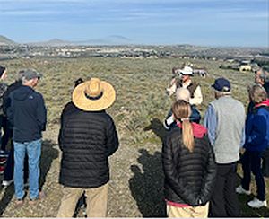
On a cool morning in late March 2026, a group of 16 curious field trip participants stood atop a scenic viewpoint in Richland, Washington looking out over the Pasco Basin, with the Yakima and Columbia Rivers silently flowing below. George Last, a local geologist and field trip leader for the Lake Lewis Chapter of the Ice Age Floods Institute, was explaining a sequence of geologic events that shaped the region surrounding the Tri-Cities. Massive lava flows filled the Columbia Basin with layers of basalt thousands of feet thick. The successive flows combined with tectonic forces uplifted and formed the anticlines along the local section of the Olympic-Wallowa Lineament – on clear display here as a chain of large rolling hills stretching from Rattlesnake Mountain to our northwest to the Horse Heaven Hills southeast of our vantage point. Ancestral rivers, responding to the changes in topography, changed courses across the landscape, cutting new routes towards the Pacific Ocean. Finally, a series of cataclysmic ice age floods roared in from its northerly source, backing up behind the natural constriction of Wallula Gap to form temporary Lake Lewis. The hilltop we occupied would have been completely overtopped by over 400 feet of debris-laden floodwaters.
As we looked out onto this geologic foundation, a different landscape emerged in every direction. Our hilltop is capped by a community park. Below us, and along the hillsides of the looming anticlines nearby, the shrub-steppe slopes are blanketed with view-lot homes. Spreading out all around us is a fabric of roadways, housing developments, and commercial and industrial zones. Stretching out to the horizon are the irrigated fields, vineyards and orchards that have been an economic staple of the region since the early days of frontier settlement.
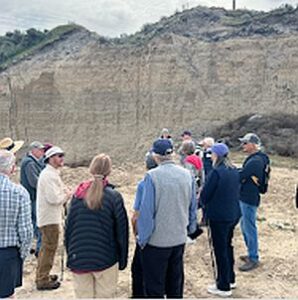
Throughout the remainder of our field trip, this juxtaposition of human settlement and natural history is ever-present. A vacant lot, surrounded on three sides by a housing development, hosts an outcrop of the Ringold formation, deposited from the ancestral Columbia River or its tributaries between 3.4 and 8.5 million years ago. An 8.5 million year old basalt flow and Ice Age flood deposits ranging from 780,000 to 220,000 years old lay exposed at various abandoned quarries and borrow pits along our route. Unfortunately, several Ice Age Floods features, previously accessible, are now sequestered behind no trespassing signs or have been lost entirely to new construction. Many participants share stories of excavators uncovering a behemoth of a glacial erratic, to be methodically broken down by hydraulic hammer and hauled away to parts unknown.
The final stop on the tour was the Coyote Canyon Mammoth Site outside Kennewick, operated by the MCBONES Research Center Foundation. The site is an active paleontology dig of a Columbian Mammoth, buried in late Pleistocene Ice Age flood deposits and loess. While our guide explains the methodical process of documenting each discovery, tour participants gaze upon a half-buried mammoth bone. One day this fragment will be fully exhumed after resting high in the hills for 17,500 years. It is interesting to think that, like those long buried erratics, this nearly complete skeleton may never have been discovered if not for someone searching with a shovel.

It is stories like MCBONES that remind us that amid all of the re-grading, paving, and backfilling, there are stories of discovery and preservation to be shared as well. Conservation and education organizations, in the Tri-Cities and other communities across the Ice Age Floods National Geologic Trail, work tirelessly to preserve natural areas, establish trail networks, and erect educational markers calling attention to the wide variety of plants, animals and geologic features across the landscape. As development continues to expand across this region, the challenge lies in recognizing that the ground beneath our feet is not just a foundation for homes and infrastructure, but a record of deep geologic time and discovery. By fostering a balance between growth and preservation, and by supporting education, research, and access to these remarkable features, we ensure that the stories written in stone–from ancient lava flows to Ice Age floods–remain visible, accessible, and meaningful for generations to come.

By John Young, Lake Lewis Chapter of Ice Age Floods Institute