Stunning Fossil Site Reveals Life Rebounding After Major Extinction Event
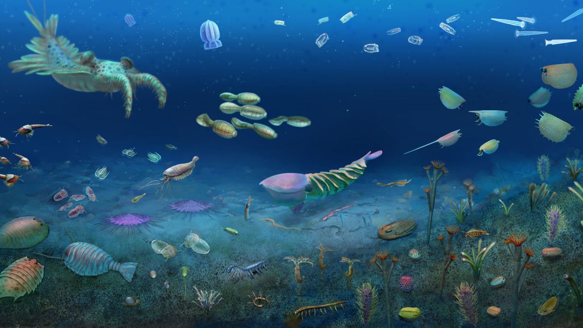
Just over half a billion years ago, Earth was rocked by a global mass extinction event, a dramatic interruption of the Cambrian explosion of life on Earth. It wiped out an estimated 50% to over 90% of animal species, particularly in marine environments. What happened next, in the direct aftermath of this event, has mostly been a mystery – until now. A newly discovered fossil site in Hunan, South China, has captured an entire ecosystem in recovery, in extraordinary detail, including soft tissues and internal structures. Nearly 60 percent of the species found within are previously unknown to science. Named the Huayuan biota, the collection boasts 153 animal species spanning 16 major groups, for a grand total of 8,681 fossil specimens recovered from a single site – and it was all recorded around 512 million years ago, hot on the heels of the Sinsk extinction around 513.5 million years ago. The richness of species and level of preservation rivals Canada’s famous Burgess Shale. Earth’s Cambrian Period, which lasted from around 540 to 485 million years ago, was a time of great change for our planet. It was during this time that the first major diversification of animal life took place – the Cambrian explosion. But the tree of life was trimmed shortly after with the Sinsk extinction event, which may have been triggered by tectonic activity. Thanks to a handful of BST Lagerstätten from around the Sinsk event, paleontologists have managed to reconstruct some of the effects it had on life on Earth. The Burgess Shale in the Canadian rockies is about 508 million years old; the Qingjiang biota and the Chengjiang biota, both in China, are about 518 million years old. These sites helped scientists discover that, while many shallow-water species were killed off in the Sinsk event, life managed to rebound within a few million years. Dated to around 513 million years old, the Huayuan biota is a direct window into the immediate aftermath of the extinction event. It shows that at least some ecosystems – namely, deeper waters – served as safe refuges. The fossils themselves reveal a rich and diverse ecosystem, filled with predators and prey alike. Their preservation includes far more than just their external shapes and textures – in many cases, internal organs and soft tissues were captured in exquisite detail, including nervous systems and even cellular structures. Other structures preserved include gut diverticula and optic neuropils, offering rare glimpses into ancient digestive systems and nervous tissue. The site will keep scientists busy for many years to come. Earth has quite a few tricks up its sleeve for fossilization, but the Huayuan biota is truly a shining rarity. It belongs to an elite class of fossil deposits known as Lagerstätten – fossil beds that have both exceptional richness and exceptional preservation. But it’s not just any Lagerstätte; a team led by paleontologist Maoyan Zhu of the Chinese Academy of Sciences has classified the Huayuan biota as a Burgess Shale-type (BST) Lagerstätte – the very rarest and finest type of fossil bed, where soft-bodied animals and delicate internal tissues are preserved as a rule, not an exception. The biota contains arthropods such as trilobites and apex-predator radiodonts, and invertebrates like sponges, comb jellies, and sea anemones. What makes this special is that many of these animals appear to have been preserved where they lived, rather than being swept in from elsewhere. This means that researchers can make inferences about their behavior; for example, a number of vetulicolians were preserved in groups, suggesting that they shoaled together in life. Perhaps the most surprising discovery is that of the world’s oldest known pelagic tunicate, a group of filter feeders that today play a major role in the ocean’s carbon cycle. The presence of free-swimming tunicates in the biota suggests that surprisingly modern-style ocean ecosystems were already taking shape soon after the Sinsk extinction. The other really exciting part is that the researchers compared their biota with other Cambrian Lagerstätten. They found that the Huayuan biota bears some striking similarities to the Burgess Shale fossil site. Several iconic animals once thought to be unique to the Burgess Shale, such as Helmetia and Surusicaris, appear in the Huayuan assemblage as well, even though the two sites are separated by thousands of kilometers and millions of years. It’s an absolutely magnificent find, and one that’s likely going to become crucial for understanding the Cambrian Earth. “The extraordinary biodiversity of the Huayuan biota provides a unique window into the Sinsk event by revealing the post-extinction recovery or radiation in the outer shelf environment,” the researchers write. “It indicates that the deep-water environment might have played a crucial role for structuring the global marine animal diversification and distribution since the early Cambrian.” The research has been published in Nature. This article is taken from a Science Alert article by Michelle Starr
IAFI Store – Winter Inventory Reduction Sale

The IAFI Store is having a special Winter Inventory Reduction Sale to make room available to add new items and updated items as they become available. This is a great opportunity to get Floods-related presents for family, friends, and maybe yourself at (often) steeply reduced prices. And every order will include a free IAFI window decal you can use to let others know you’re passionate about the features and the science behind the cataclysmic Ice Age Floods story. Share the Ice Age Floods story this Christmas! The IAFI Store’s Winter Inventory Reduction Sale is here – and it’s your chance to dive deep and share the story of these spectacular events. We’re making room for exciting new items, which means steep discounts of 10% to over 40% on a selection of Ice Age Floods merchandise. Whether you’re shopping for the Floods enthusiast in your life, a curious student, or treating yourself to something extraordinary, now’s the perfect time to explore the fascinating world of the cataclysmic floods that carved the Pacific Northwest. What Makes This Sale Special? From educational materials that bring ancient catastrophes to life, to unique gifts that celebrate the power of water and ice, our collection offers something for every curious mind. These aren’t just presents – they’re gateways to understanding the massive forces that shaped our landscape thousands of years ago. As an added gift for you, every order comes with a free IAFI window decal – your badge of honor showing you’re passionate about the incredible science behind the Ice Age Floods story. It’s more than just merchandise; it’s a conversation starter about one of the world’s most dramatic chapters. Limited time only. Shop now while inventory lasts and discover why the Ice Age Floods continue to captivate scientists and nature lovers alike. Ready to explore? Visit the IAFI Store today and turn this Christmas into a journey through deep time.
New Ice Age Floods Animation Brings Ancient Catastrophe to Life
An Ice Age Floods Animation Developed Through Science, Partnership, and Interpretation Imagine explaining a geological event so massive it reshaped the entire Pacific Northwest—not once, but dozens of times—across landscapes spanning four states. Now there’s a powerful new tool to help tell this remarkable story. The Ice Age Floods National Geologic Trail has just released a groundbreaking animation that brings these ancient cataclysms to life. Available now through the National Park Service and the Ice Age Floods Institute, this public-domain resource represents years of collaborative effort between scientists, educators, and park partners. Why Animation Was Essential The Missoula Floods weren’t a single disaster—they occurred dozens of times during the last ice age as ice dams repeatedly formed and failed. Each flood carved the Channeled Scablands, transported house-sized boulders, and deposited thick sediment layers across the region. The challenge? Physical evidence is scattered across vast distances, and static maps can’t capture the movement, scale, and repetition that defined these events. Visitors see individual features—coulees, erratics, deposits—without understanding how they connect to a continental-scale story unfolding over thousands of years. Animation bridges this gap by showing how ice dams failed, how floodwaters surged across landscapes, and how repeated flooding shaped what we see today. A Collaborative Achievement Scientists specializing in glacial dynamics, flood hydraulics, and geomorphology worked alongside interpreters and media specialists through multiple reviews, balancing scientific accuracy with public accessibility. The result is a flexible, modular tool designed for visitor centers, classrooms, ranger programs, and online learning. Because it’s in the public domain, partners can freely adapt segments for their specific needs—whether illustrating basalt erosion or the cumulative effects of repeated flooding. Why This Matters The Missoula Floods represent one of North America’s most dramatic geological events, yet they’ve remained difficult to comprehend. This animation finally provides a shared visual framework that makes the story accessible while honoring the complex science behind it—offering an unprecedented window into the forces that carved the Pacific Northwest.
The Pulse of Rocks

“All creatures, objects, places, and elements have a spirit.” Patrick Saltonstall, Sugpiag (Aleut) Are rocks alive? Hmm. You might be visualizing a small stone or large boulder just sitting there…doing nothing. If life has to originate from a cell, then a no vote seems reasonable. Let’s give the Mineral Kingdom a few minutes to speak on behalf of its constituents: “Our rocky friends react to temperature, expand and contract; they can absorb moisture, and they can transform their makeup entirely, like petrified wood changing into stone. Taxonomy – In the 19th . century, rocks and minerals were first classified based on their chemical make-up. As with animals and plants, new members are added yearly to the mineral kingdom’s nearly 10,000 species. Movement – Rocks sure move around, from riding glacier waves, to being catapulted for miles out of fiery volcanoes to being gently tumbled downstream by…streams, and through time, broken down into sandy beaches. Or, if you’re pumice, you can simply float downstream at your leisure. Any pebble has placed many travel stickers on its luggage finding itself in many lands during its long life. Stalagmites and stalactites check off another life form requisite by respectively growing up and down in caves with the help of slowly dripping water. Rock serves us well in concrete, road building materials, sculptures, and stone homes, all making us Salt of the Earth. Reproduction and Growth – Kidney stones are minerals and salts formed in urine. They form and grow in the bladder and kidneys. The imbalance of too many minerals in the urine and not enough liquid causes the minerals to reproduce and grow. Cooperation – Practically all living things rise out of soil, which is a mixture of organic and inorganic magic. Plants need both. Animals need minerals too. Salty seas cover a major chunk of our planet providing a swimming pool habitat to countless known and still to be known species Awe Inspiring – Rocks are the basis for our most beloved national, natural treasures, from the timeless Grand Canyon, to Yosemite’s granite walls, towering Mt. Rainier, the sandstone Arches, and the Grand Tetons, among many others. We are moved to witness sunrise and sunset light beaming red, and filtered white on mountain peaks. We climb boulders; we summit mighty bare rock and snow-covered mountains for the view, for the peace, perhaps for the love, too. The Fine Line – Everything that is living on our precious planet originated with and within the rocky world, making it a challenge to separate the line between non-life and existence. We are made of stars. We are made of star spirit. A wildlife biologist/naturalist reflects on lithologic ‘life’, Bill Weiler, January 2026
Doug Huber – Key Puget Lobe Chapter Volunteer
Doug Huber has been an active member of the Puget Lobe Chapter of IAFI almost since its inception in 2007. For the past ten years, Doug has been the unseen hero of our chapter meetings, where he has ensured that the computer, audio, and projection systems were maintained and working as they should at the start of our meetings. In addition, Doug has served as our webmaster, updating the chapter webpage so that our members and members of other chapters alike had access to information on our field trips, meetings, and special events. Hats off to you, Doug, for your tireless efforts to help our chapter stay strong!
K-12 Ice Age Floods Curriculum: Floods in the Classroom
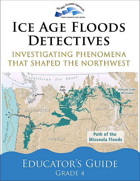
Thousands of K-12 students across the Pacific Northwest are becoming Ice Age Floods detectives—investigating ancient catastrophic flooding, conducting hands-on experiments, and sharing geological discoveries with their communities. Some may be inspired to become scientists who will ask new questions and conduct research that will advance our understanding of these ancient megafloods. This transformation is happening through Ice Age Floods Detectives, a new grade school science curriculum funded by the Ice Age Floods Institute (IAFI) and developed through partnership with the Ice Age Floods National Geologic Trail (NPS), and Engaging Every Student. The Ice Age Floods Detectives program is comprised of four phenomena-based ~1-hour lessons, targeted to grade 4 but adaptable for grades 3–8, to be taught in order over a week or more. Lesson 1: Modeling Ice Age Floods Erosion. Students create watershed models to visualize how water flows and reshapes the landscape. Lesson 2: Investigating Deposition. Students observe how different rocks and landforms are created by deposition, connecting these small-scale experiments to the massive scale of the Ice Age Floods. Lesson 3: Creating Kinesthetic Classroom Models. Students use physical movement and simple materials to model incredible scale of Ice Age flooding, weathering and erosion. Lesson 4: Exploring the Erosion Energy of Moving Water. Students experiment with water speed and volume to understand its erosive forces and to practice designing scientific experiments. Students will explore the scientific processes geologists use to make discoveries, and how the fascinating area of science—like most other disciplines—is dynamic and constantly changing. The lessons help students explore phenomena and investigate how they relate to observable geologic features. Students are gradually introduced to concepts, processes, and theories that will assist them in forming and revising their own explanations and hypotheses about the Ice Age Floods. These adaptable lessons help train students to be good scientists and critical thinkers, with a unifying theme of exploration and investigation. When the lesson plans are delivered in sequence, a storyline develops, using the creation of our NW landforms as a compelling framework to help cover core concepts and improve student skills. Numerous studies have identified the need for improved STEAM (Science, Technology, Engineering, Arts, Mathematics) education that connects to students’ lives and communities. Research indicates that grades 4-6 are particularly critical for engaging students and encouraging them to pursue STEAM fields. Those grades are a particular focus of the program, which will help us address the critical need for more scientists and engineers. The curriculum complies with Next Generation Science Standards + Common Core State Standards, and should not compete with other curricular goals for classroom time. This program updates and complements the earlier NPS Investigating Ice Age Floods K-12 curriculum. We’re bringing this curriculum to educators throughout Washington, Oregon, Idaho, and Montana through regional workshops. Ice Age Floods Institute has also established an IAFI K-12 Education Grant Program to help educators offset attendance costs and classroom implementation expenses. You can also help support the program and play a significant part in inspiring the next generation of scientists: Donate fee-free through our Zeffy Fundraiser or IAFI Gorge Chapter’s PayPal Giving Fund Share information and leads about potential funding sources— contact us at IAFIGrants@gmail.com Share this flyer with educators in your community to help spread the word
Malaga Landslide: Ice Age Catastrophe Along the Columbia River
The east bank of the Columbia River near Malaga, Washington, is home to one of the largest and most visually striking landslides in the Pacific Northwest: the Malaga Slide. Covering an estimated 45 square miles, this massive slope failure poured weakened basalt and sediment into the Columbia River valley at the close of the last Ice Age. Today, it remains easily visible from State Route 28, making it an accessible outdoor classroom for geology enthusiasts and tour participants. The geologic story of the Malaga Slide is a tale of both slow preparation and sudden catastrophe. Layers of basalt from the Columbia River Basalt Group were fractured and weathered over millions of years. Interspersed with weaker sedimentary layers, these formations became prone to failure. Add in groundwater saturation, the erosive power of repeated Ice Age Floods, and over-steepened valley walls, and the stage was set for a massive collapse. Scientists believe the main phase of the Malaga Slide occurred approximately 15,000–13,000 years ago, during the final stages of the Missoula Floods. While the collapse itself was sudden, the landslide likely continued to adjust and move over time, creating the hummocky terrain and displaced boulders still visible today. One of the most intriguing aspects of the Malaga Slide is its interaction with the Columbia River. Some geologists have hypothesized that the massive slide may have temporarily blocked or partially dammed the river. This could have caused short-term ponding upstream, potentially extending back toward Peshastin. Evidence of this interaction remains visible today as enormous boulders and slide debris in the river channel. Travelers heading south from Wenatchee on State Route 28 are treated to a dramatic view of the slide, with scarred slopes and scattered boulders lining the west side of the river. This visibility makes the Malaga Slide an outstanding site for guided geology tours offered by the Wenatchee Valley Erratics Chapter of the Ice Age Floods Institute. Participants learn about Ice Age Flood processes, landslide mechanics, and the long-term evolution of the Columbia River valley. Learn more about Wenatchee-area geology tours: https://wverratics.org or contact@wverratics.org Article by Jeff Becklund, Wenatchee Valley Erratics Chapter President
The Bowl & Pitcher at Riverside State Park
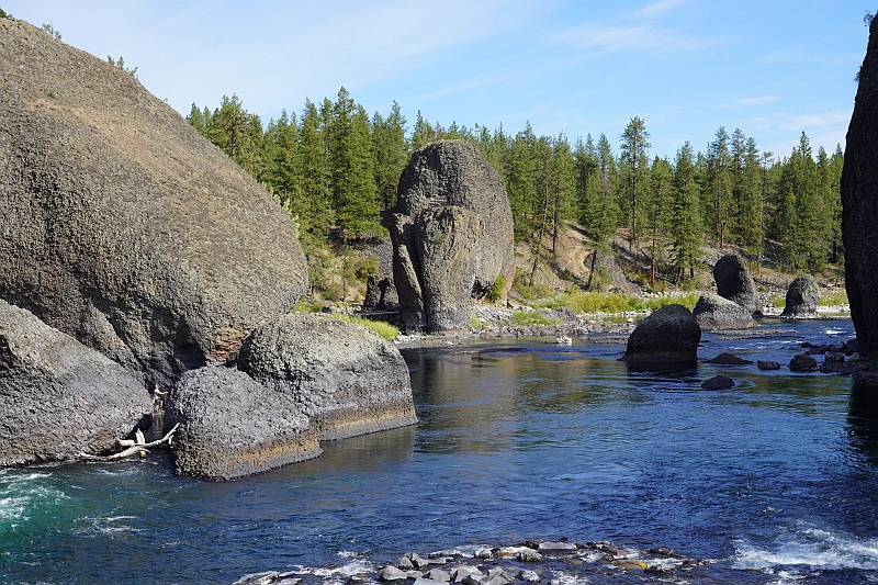
The Bowl and Pitcher is a rock formation along the Spokane River and one of the most scenic sites in the area, with basalt cliffs rising 500 feet above the river and large blocks of basalt in the river causing large rapids. The “Bowl” is a circular depression in the river and the “Pitcher” is a large detached block of highly fractured basalt. The geology of Spokane’s Bowl and Picher features dramatic basalt cliffs carved out of the flows from the Columbia River Basalt Group (CRBG), which reached this area 16 million years ago. There are river and flood deposits of sand and gravel, with granitic boulders forming terraces on the east side of the river, and huge blocks of basalt, causing the Dragon Tooth rapids, downriver from the Bowl and Pitcher. How did those rocks get there? The Spokane and Columbia rivers occupy a long, mostly bedrock canyon near the northeastern boundary of the Columbia Plateau. Glacial Lake Columbia, which formed behind the Okanogan ice lobe, occupied all of the Spokane River and a portion of the Columbia drainage basin during the last Ice Age. Then the glacial Lake Missoula outburst floods first surged over the Columbia Basin beginning around 17,000 years ago, ripping away the CRBG and other bedrock from Bayview, Idaho, to the Pacific Ocean. These floods also deposited a thick sequence of flood gravel in the valley. As Lake Columbia water level dropped, the Spokane River began to remove the sand and gravel fill. Subsequent floods continued to remove the flood deposits, leaving the basalt benches on the west side of the river and the terraces on the east side. Riverside State Park is located northwest of Spokane and consists of over 9000 acres along the Spokane and Little Spokane Rivers. The park is the second largest state park and has many recreational activities including, camping, hiking, mountain biking, horseback riding and boating (Discover Pass required). There are two view points for the Bowl and Pitcher. The first is from a small parking lot off the entrance road from Aubry White Parkway that provides an elevated view of the site. The main parking area is down along the river with a picnic area and a network of trails. From the parking lot you can follow the wheelchair accessible path across the suspension bridge over the Spokane River. From the bridge you can enjoy a view of the features that give the site its name. The original bridge was built in 1942 by the Civilian Conservation Corps. The existing bridge, based on the same plans, opened in 1998. On the west side of the river, you can access a network of trails along the river or climb up along the bluffs above the river.
Inspire New Generations
with the Ice Age Floods Story Help bring one of North America’s most dramatic geological events into Pacific Northwest classrooms Join Us in Making an Impact Help students discover the powerful forces that shaped our region’s landscape The Ice Age Floods Story The Ice Age Floods carved spectacular landscapes across Washington, Oregon, Idaho, and Montana—creating the dramatic geology we see around us today. The landscape of the Pacific Northwest tells a powerful story of earth-shaking forces—but does our next generation know how to read it? The IAFI K-12 Education Grant Program The Ice Age Floods Institute is launching a new K-12 Education Grant Program empowering teachers to take students beyond the textbook to explore the science in the classroom and field. Grants of up to $500 will give educators the resources they need to spark curiosity about the landscape before their eyes and beneath their feet. Now, through the IAFI K-12 Education Grant Program, you can help students experience this incredible story firsthand. Building for the Future Our pilot program launches with $5,000 in seed funding from IAFI and our 11 local chapters. The program will initially focus on 4th grade classrooms in support of with our new IAFI 4th Grade Curriculum Project. With your support, we can expand the program to serve students throughout K-12 grades across the region—creating a lasting educational legacy. $500 Maximum Grant per Educator 100% of Funds Go to Help Students Why This Program Stands Out Our K-12 Education Grant Program and your donations will help empower educators to enhance Ice Age Floods curriculum with: Field trips to flood-carved landscapes where students can read the story written in the rocks Classroom materials and educational resources that make complex geology accessible Hands-on demonstrations and interactive activities that spark curiosity Professional development opportunities for educators Geographic Reach Priority is given to schools in the core Ice Age Floods impact zones across Washington, Oregon, Idaho, and Montana. We also welcome applications from the broader region for educational initiatives related to the Ice Age Floods. How Your Gift Powers Discovery Every dollar you donate directly supports hands-on learning experiences. Our team donates grant administration, and through our partnerships with Zeffy and PayPal Giving Fund there are zero processing fees, so your entire donation will go to work to fund classroom materials, interactive activities and field trips that bring the Ice Age Floods and science to life. Donate to the IAFI K-12 Education Grant Program Zeffy Fundraiser payPal Giving Fund Your Support Makes a Difference Donated administration by our all-volunteer team and our partnerships with Zeffy and PayPal Giving Fund eliminate processing fees and ensure maximum impact, so your full donation directly fuels student discovery. Together, we’re not just teaching the Ice Age Floods story—we’re inspiring young people to share this remarkable story with their families and communities. Questions? Email us at IAFIgrants@gmail.com Help expand the program, donate fee-free with several payment options through our Zeffy Fundraiser or PayPal Giving Fund links Our fiscal sponsor, IAFI Columbia Gorge Chapter, is a federally registered 501(c)(3) non-profit organization. Your donation may be tax deductible
Why Are Basalt Columns Mostly Hexagonal “Bestagons”
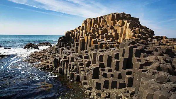
The Giant’s Causeway is a rock formation that is so otherworldly that it seems like it was made by supernatural beings. But these incredible hexagonal columns of rock aren’t the result of giant masons. They formed through a quirk of volcanic activity that shows that hexagons really are the bestagons! Cooling lava naturally creates hexagonal cracks to evenly relieve stress When lava cools and turns into rock, it contracts and builds up tension, particularly when held in place by the surrounding landscape. Just as drying mud cracks, initial cracks in the rock are random, but quickly organize into a hexagonal pattern, which scientists consider the most space-efficient shape. Note: the presentation talks about lava cooling from the top down, but it also cools upward from the bottom where it flowed onto a cooler land surface. In our area we typically see columns underlying a more chaotically fractured “entablature”. It is generally thought that because the entablature section is exposed to the air and precipitation, that results in rapid cooling that produces chaotic fracturing. The columnar section which is cooling upward from the base, would experience a much slower and more even rate of cooling, allowing it to better organize into an optimal, space-efficient “bestagonal” shape. Found via SciShow, hosted by: Niba @NotesbyNiba