Introducing IAFI’s K-12 Education Grant Program
Empowering Teachers and Students to Share the Ice Age Floods Story Micro-grants of up to $500 now available for K-12 educators Application Period Opens January 5, 2026 The Ice Age Floods Institute is proud and excited to announce a groundbreaking initiative to bring one of Earth’s most dramatic geological stories into classrooms across the Pacific Northwest. Our new K-12 Education Grant Program provides targeted funding to help teachers and students explore, understand, and share the remarkable Ice Age Floods narrative with their communities. The Challenge We’re Addressing The Ice Age Floods story may seem straightforward to those who’ve studied it, but explaining these catastrophic events to newcomers can be surprisingly complex. Teachers need effective guidance and quality materials to bring this geological phenomenon to life in their classrooms. Students who become fascinated by the floods can inspire others. IAFI recognizes that reaching K-12 students is one of the most effective ways to educate young people, and through them to share this incredible story with their families and communities. Our Solution: Micro-Grants up to $500 That Make a Difference These carefully designed micro-grants help defray the costs of materials, field experiences, and project development for classroom instruction throughout Idaho, Montana, Washington, and Oregon. By providing this crucial support, we’re creating a ripple effect of interest and knowledge that extends from students to their families and friends. How Grants Can Be Used We’ve designed this program with flexibility in mind, understanding that teachers and students have diverse needs and creative approaches to sharing the Ice Age Floods story. These grants are meant to support classroom activities including curriculum materials, educational supplies, guest speaker fees, and field trip expenses to Ice Age Floods sites throughout the Pacific Northwest. The Power of Student Engagement When students develop genuine interest and excitement about the Ice Age Floods, they become natural ambassadors for the story. They share their enthusiasm with family members over dinner, explain geological concepts to friends, and carry this knowledge forward throughout their lives. This program doesn’t just fund classroom teachers—it creates a generation of informed advocates for geological education, research and preservation. What Makes This Program Special Our grant program initially focuses on 4th grade educators in support of the IAFI 4th Grade Curriculum Project. This strategic approach allows us to build a strong foundation before expanding to all K-12 teachers and students in future years. It’s For Educators Teachers can apply for funding to enhance their Ice Age Floods curriculum through: Classroom materials and educational resources Field trip expenses to visit actual flood-carved landscapes Hands-on demonstrations and interactive activities Professional development opportunities 2026 Grant Cycle December 2025 – Application details and forms posted to IAFI.org website January 2026 – Application window opens, applications accepted on an ongoing basis Grant awards will be approved and announced within 2 months of application, 90% of grant will be awarded 12 Months – Period for using awarded grant funds and sharing a final report with IAFI, then the final 10% of of the grant will be awarded Simple Application Process We’ve designed our process to be straightforward and educator-friendly. Applications are accepted year-round starting January 2026, with a two-month review period. Once approved, recipients have one year to complete their projects, followed by a six-month window to share their results with the IAFI community. Click here to apply. $5,000 Annual IAFI Program Funding Commitment and Growth The program is initially funded with a $5,000 annual commitment by the Ice Age Floods Institute and our 11 local chapters, to support multiple projects each year. We’re committed to growing this program through donations from IAFI members, businesses, educational grants, and other philanthropic sources. We anticipate significant interest from current members and believe that a successful grant program will help attract new supporters to IAFI’s mission. Your support can directly impact the next generation of geological enthusiasts. Whether you’re an individual member, a local business, or an organization committed to education, your contribution helps ensure that more students and teachers can access the resources they need to share the Ice Age Floods story effectively. Donate fee-free through IAFI Gorge Chapter’s PayPal Giving Fund connection Join Us in Making History Come Alive This Scholar Support Grant Program represents more than just funding—it’s an investment in geological literacy, scientific curiosity, and the preservation of our region’s remarkable natural heritage. By supporting teachers and students as they explore the Ice Age Floods, we’re ensuring that this incredible story continues to inspire wonder and understanding for generations to come. Get Involved Whether you’re an educator ready to apply, a potential donor, or simply curious to learn more, we invite you to be part of this exciting initiative. An IAFI team is completing the details, application information and donation links that will be available on IAFI.org in December 2025. Questions? Email us at IAFIgrants@gmail.com
Inspire New Generations
Inspire New Generations with the Ice Age Floods Story Help bring one of North America’s most dramatic geological events into Pacific Northwest classrooms Join Us in Making an ImpactHelp students discover the powerful forces that shaped our region’s landscape Donate to IAFI K-12 Education Grant Program Our fiscal sponsor, IAFI Columbia Gorge Chapter, is a federally registered 501(c)(3) non-profit organization.Your donation may be tax deductible The Ice Age Floods StoryThe Ice Age Floods carved spectacular landscapes across Washington, Oregon, Idaho, and Montana—creating the dramatic geology we see around us today. The landscape of the Pacific Northwest tells a powerful story of earth-shaking forces—but does our next generation know how to read it? The IAFI K-12 Education Grant Program The Ice Age Floods Institute is launching a new K-12 Education Grant Program empowering teachers to take students beyond the textbook to explore the science in the classroom and field. Grants of up to $500 will give educators the resources they need to spark curiosity about the landscape before their eyes and beneath their feet. Now, through the IAFI K-12 Education Grant Program, you can help students experience this incredible story firsthand. $500 Maximum Grant per Teacher 100% of Your Gift Goes to Help Students Your Gift Powers DiscoveryEvery dollar you donate directly supports hands-on learning experiences. Our team donates grant administration, and through our partnership with PayPal Giving Fund there are zero processing fees, so your entire donation will go to work to fund classroom materials, interactive activities and field trips that bring the Ice Age Floods and science to life. Why This Program Stands OutOur K-12 Education Grant Program and your donations will help empower teachers to enhance Ice Age Floods curriculum with: Field trips to flood-carved landscapes where students can read the story written in the rocks Classroom materials and educational resources that make complex geology accessible Hands-on demonstrations and interactive activities that spark curiosity Professional development opportunities for educators Building for the FutureOur pilot program launches with $5,000 in seed funding from IAFI and our 11 local chapters. The program will initially focus on 4th grade classrooms in support of with our new IAFI 4th Grade Curriculum Project. With your support, we can expand the program to serve students throughout K-12 grades across the region—creating a lasting educational legacy. Geographic ReachPriority is given to schools in the core Ice Age Floods impact zones across Washington, Oregon, Idaho, and Montana. We also welcome applications from the broader region for educational initiatives related to the Ice Age Floods. How Your Support Makes a DifferenceDonated administration by our all-volunteer team and our partnership with PayPal Giving Fund to eliminate fees, ensures maximum impact, so your full donation directly fuels student discovery. Together, we’re not just teaching the Ice Age Floods story—we’re inspiring young people to share this remarkable story with their families and communities. Questions? Email us at IAFIgrants@gmail.com Donate fee-free through IAFI Gorge Chapter’s PayPal Giving Fund connection to help expand the program
Why Are Basalt Columns Mostly Hexagonal “Bestagons”
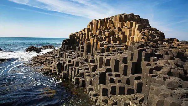
The Giant’s Causeway is a rock formation that is so otherworldly that it seems like it was made by supernatural beings. But these incredible hexagonal columns of rock aren’t the result of giant masons. They formed through a quirk of volcanic activity that shows that hexagons really are the bestagons! Cooling lava naturally creates hexagonal cracks to evenly relieve stress When lava cools and turns into rock, it contracts and builds up tension, particularly when held in place by the surrounding landscape. Just as drying mud cracks, initial cracks in the rock are random, but quickly organize into a hexagonal pattern, which scientists consider the most space-efficient shape. Note: the presentation talks about lava cooling from the top down, but it also cools upward from the bottom where it flowed onto a cooler land surface. In our area we typically see columns underlying a more chaotically fractured “entablature”. It is generally thought that because the entablature section is exposed to the air and precipitation, that results in rapid cooling that produces chaotic fracturing. The columnar section which is cooling upward from the base, would experience a much slower and more even rate of cooling, allowing it to better organize into an optimal, space-efficient “bestagonal” shape. Found via SciShow, hosted by: Niba @NotesbyNiba
Missoula Chapter Field Trip TV News Coverage
Missoula chapter field trip – tv news coverage Recently the Montana Natural History Center identified a group of people new to the floods that wanted to do “something” outdoors, but not too early, or too long, or too strenuous, or too late. So IAFI’s Glacial Lake Missoula Chapter worked with the Center to put together a 4 hour, middle of the day field trip. We saved money by using the History Center short bus and our History Center liaison as our driver. Bring your own lunch and water, dress for short hikes and variable weather. The short bus limited us to twelve plus a speaker. We went for $60 per person, $40 for IAFI members, students and Natural History Center members. The trip sold out instantly as soon as we started to publicize. Chapter president Jim Shelden said, “I was surprised that much of the interest was from members that had done 1 or more trips before. The rest was from other newbies. Clearly we want to do more of this.” On trip day a reporter from the local KPAX-TV news popped in and wanted to come along, but he had to follow the bus because we were out of room. A member of The History Center board of directors also wanted to come along, so since we had no seat for him and he wanted to talk more with the reporter, he rode with the reporter. The reporter also needed to be back in town by one PM to edit and get the video ready, so we ran the trip in reverse order to get the summation speech in for our new guests to make the deadline. Then we proceeded to the other sites to show the other participants all the evidence. The day was beautiful with lunch by the river and the reviews were very good. The station got good feedback, the board member was pleased talking to the participants, and we will make the station aware of all our events in the future.
Jeff Becklund

Wenatchee Valley Erratics Chapter President Retired 42 yrs Licensed Coast Guard Captain. Retired Senior Captain Trilogy Excursions . Bellevue High School. Western Washington State College, 74-78, Recreation Park Management Program. Moved to NW in 2020 now resides in Wenatchee. Americorp Volunteer 2022-2025, serving at Wenatchee Valley Museum and Cultural Center as Program and Tours Coordinator. Coordinated tours for Ken Lacy and Brent Cunderla. Supported Wenatchee Valley Erratics Chapter tours since 2023
There IS such a thing as ‘settled science’
How bad-faith arguments sow doubt by weaponizing scientific humility Good advice to consider when either claiming or questioning scientific (and geologic) theories and hypotheses “Science is never settled” has become a go-to slogan for populists seeking to legitimize fringe scientific positions. In 2020, Representative Nancy Mace was asked whether she agreed that climate change is the result of humanmade greenhouse emissions. She responded: “My opponent has said that the science is settled on this. Well, the science is never settled. Scientists will tell you that.” In February, Senator Roger Marshall argued more money should be spent on investigating widely debunked links between autism and vaccines, saying “I’m a physician. Science is never settled. That’s what makes us scientists.” When U.K. Reform party leader Nigel Farage was pressed on whether he would “side with medical experts who say ‘a link between Tylenol use in pregnancy and autism’ is dangerous nonsense,” he responded, “When it comes to science, I don’t side with anybody… because science is never settled.” The issue is, of course, that in many areas, from the theory of evolution to the theory of gravity, science is very much settled. To pretend otherwise is to misrepresent the position of the scientific community. That doesn’t mean that scientific positions are eternally fixed and can’t be updated in light of new evidence. It means that our current best explanations have been tested enough for us to be confident that they are good descriptions of the way things work. Myth of overturned consensus A favorite trope of climate denialists is that scientists in the 1970s predicted “global cooling” — an imminent ice age. It’s a smart argument, because if you can suggest that the exact opposite of global warming was once the prevailing view, surely you throw the current consensus on climate science into doubt? Despite media attention and much discussion of the idea, global cooling was never a consensus scientific position. Reviews of the literature at the time show that even 50 years ago, global warming dominated scientific thinking about the Earth’s short-term climate future. That climate change is the result of greenhouse gas emissions is now very much the consensus scientific position. There are, however, examples in science where consensus positions have been modified or updated. Gravity is a classic case. Galileo established that acceleration due to gravity is the same for all objects near Earth’s surface. But it wasn’t until Newton that we had a universal theory of gravitation. Newton’s theory unified the behavior of objects falling on earth with the motions of planets. For years, every measurement seemed to confirm it, and the theory became known as a “law” that nature was thought to obey without exception. But as experiments expanded and instruments improved, the edges of Newton’s “law” began to fray. When dealing with strong gravitational fields like those near a black hole, or when calculating to high precision or over short astronomical distances, Newton’s law wasn’t sufficient. In the 20th century, Einstein’s general relativity filled many gaps — resolving a range of seeming astronomical anomalies and describing how light bends near a black hole. Yet even the relativistic interpretation of gravity is not perfect. We know, for example, that it must break down inside a black hole. First Galileo’s and then Newton’s theories were superseded, and we know Einstein’s isn’t correct in every situation. Does that mean these earlier theories are useless and not examples of settled science? Definitely not. In contexts where these theories have been rigorously tested and shown to give the correct answers (to a given degree of precision), they remain valid. They aren’t wrong — just special cases of the more general theories, valid within a given domain of legitimacy in which they were originally postulated and tested. In the same way, whatever supersedes Einstein’s theory will have to include it as a special case. The example of gravity shows that scientific knowledge can evolve yet still be considered settled within its domain of legitimacy. We can point to other consensuses, like evolution or germ theory, as settled science that has been expanded and generalized over time. Scientific ‘facts’ There are also questions that most would call definitively settled. That Earth is round, not flat, is perhaps the most obvious. But whether we choose to call this a “fact” or not depends on how we define the word. If we demand 100% certainty, science can’t provide it. If you want certainty, you need to look to mathematics, where knowledge is built through deduction from axioms (a fundamental set of premises), independent of the world. Science, in contrast, built on evidence and induction, can only ever offer increasing confidence. A key premise of the scientific method is openness to new evidence. If you consider yourself 100% certain, then no new evidence, however convincing, can change your mind. That is not good science. However, if you accept that science provides evidence for hypotheses, it can offer what we might call indisputable evidence — so robust that disputing it isn’t a tenable position. Overturning the not-flat worldview would require such a massive reconsideration of what we understand about reality as to make it practically impossible. So, “settled science” does not mean we know something with absolute certainty, but that the weight of evidence is heavily in favor of this interpretation. Perhaps more importantly, if someone wants to change the currently held conception, the burden of proof is on them. All scientific knowledge comes with uncertainty. That is the hallmark of good science. But uncertainty doesn’t mean we cannot confidently assert that entropy always increases (the second law of thermodynamics) or that Earth orbits the sun. Science embraces uncertainty and is open to revision when new information appears, but that does not mean we shouldn’t take a position when the evidence stacks up on one side of the balance. Issues that have been rigorously tested can still be considered settled. Not being 100% certain isn’t the same as being 50-50. Admitting doubt isn’t the same as both-siding a one-sided issue. The fact that scientists acknowledge uncertainty isn’t a reason for championing false balance. But these are the fallacious positions populists are taking when
IAFI Store – Winter Inventory Reduction Sale

The IAFI Store is having a special Winter Inventory Reduction Sale to make room available to add new items and updated items as they become available. This is a great opportunity to get Floods-related presents for family, friends, and maybe yourself at (often) steeply reduced prices. And every order will include a free IAFI window decal you can use to let others know you’re passionate about the features and the science behind the cataclysmic Ice Age Floods story. Share the Ice Age Floods story this Christmas! The IAFI Store’s Winter Inventory Reduction Sale is here – and it’s your chance to dive deep and share the story of these spectacular events. We’re making room for exciting new items, which means steep discounts of 10% to over 40% on a selection of Ice Age Floods merchandise. Whether you’re shopping for the Floods enthusiast in your life, a curious student, or treating yourself to something extraordinary, now’s the perfect time to explore the fascinating world of the cataclysmic floods that carved the Pacific Northwest. What Makes This Sale Special? From educational materials that bring ancient catastrophes to life, to unique gifts that celebrate the power of water and ice, our collection offers something for every curious mind. These aren’t just presents – they’re gateways to understanding the massive forces that shaped our landscape thousands of years ago. As an added gift for you, every order comes with a free IAFI window decal – your badge of honor showing you’re passionate about the incredible science behind the Ice Age Floods story. It’s more than just merchandise; it’s a conversation starter about one of the world’s most dramatic chapters. Limited time only. Shop now while inventory lasts and discover why the Ice Age Floods continue to captivate scientists and nature lovers alike. Ready to explore? Visit the IAFI Store today and turn this Christmas into a journey through deep time.
Kititas Valley Historical Museum – Ellensburg
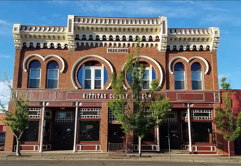
IN THE CITY OF ELLENSBURG… when you want to spend some time indoors, a great place to visit is the KITTITAS VALLEY HISTORICAL MUSEUM. It has about 30,000 items from which more than 50 exhibits and displays are chosen. The mission of the museum is to, “Collect, Preserve and Share the History, Heritage, and Culture of Kittitas County.” In experiencing it you feel a strong connection to the Pacific Northwest. Collection highlights include: Indigenous cultural items (especially from the K’tɨ́taas and Pshwánapam bands). Note the roots here for the local names of Kittitas and Wanapum. Geological specimens, including Ellensburg Blue Agate Some fossilized animals Household goods, textiles, and furnishings Military memorabilia and service records Historic photographs and albums Agricultural tools and equipment Business records and local commerce material Even the building itself is interesting. Built of brick, it was constructed after the Great Ellensburg Fire of July 4, 1889. (There is an exhibit about that fire and its devastation to the town). Some examples of what you will see: So, if you are so inclined, spend some time and enjoy. The museum is open Monday through Saturday from 10am to 4pm. The address is 114 E. 3rd Ave. Ellensburg Admission is free and donations are accepted. Article by Mike Doran: President of the Ellensburg Chapter of the Ice Age Floods Institute
Glacial erratics of the Puget Lowland
Strewn among the forests of the Puget Lowland are an impressive array of Glacial Erratics. Although technically erratics include small pebbles and even sand grains in till, people tend to get the most excited by really big erratics- those the size of a house or building. Whatever their size, glacial erratics often reveal the direction of the ice flow that ripped them from their source region and deposited them at their resting place. Erratics can also help determine the thickness of the ice sheet that deposited them. In the Seattle area, it is relatively straightforward to determine the provenance of erratics containing quartzite, as that rock can not be found anywhere in the Olympics, the Cascades, or in the native bedrock of the Puget Lowland. Quartzite, which is durable and resistant to weathering, is commonly found in river valleys of central British Columbia and in the glacial tills of the Puget Lowland. However, granodiorite erratics found in the lowland and on the slopes of the Olympics and Cascades can be more difficult to decipher. The granodiorite in these erratics is chemically similar to rock bodies both in the British Columbia Coast Mountains and in the Cascades. In the mountains east of Bellingham, erratics found at 5,000 ft of elevation imply that the thickness of the Puget Lobe of the Cordilleran Ice sheet was at least 5,000 ft thick at that location. Maps showing the thickness of the Cordilleran Ice Sheet at various places in Western Washington are drawn, in part, by looking at the depositional altitude of erratics on ridges around the region. The two most massive erratics in the Puget Lowland are composed of Greenschist metamorphic rock. One of the giant erratics of Western Washington hides in the forest in Saratoga Woods Park on Whidbey Island. The Waterman erratic is 38ft high and has a circumference of 135 ft. Analysis of the rock shows that it is composed of Greenschist, a rock containing the low grade metamorphic minerals Chlorite and Epidote. The Greenschist chemically matches the rock of Mt. Erie, a prominent Roche Moutonée found 40 miles to the north on Fidalgo Island. An even larger erratic can be seen in a suburban neighborhood near Everett. The Lake Stevens erratic, 34 ft tall with a circumference of 210 ft, is considered the largest erratic in the Northwest, and possibly the largest erratic in the United States. This erratic is also composed of a Greenschist, although chemical analysis cannot give us a definitive origin for the big rock. There is similar Greenschist on the northern tip of Whidbey Island at Deception Pass, around Mt. Shuksan in the North Cascades, and also up the Fraser River in British Columbia. Article by Dale Lehman
Julie Bishop – Coeur du Deluge Volunteer
Julie Bishop is a founding member of the Coeur du Deluge Chapter of the ice Age Floods Institute and the only continuous member of the Chapter. She has served as Treasurer of our chapter for at least 15 years. Her service to the Coeur Du Deluge Chapter goes way beyond taking care of our financial needs. Julie was and is always there supporting our chapter’s activities (public lectures, field trips and the distribution of IAF-related educational material). She did and does this cheerfully and efficiently. She somehow finds time for our chapter even though she has a full-time job with the Idaho Department of Highways. She has another full-time job at home taking care of the family farm, especially their horses. Julie casually brushes off her contributions to IAFI and Coeur du Deluge, saying that although she did some of the “legwork to start the chapter” the ultimate responsibility for the creation of our chapter was based on the long time flood interest of her friends and co-founders of the CDD Chapter: Kermit Kiebert, Jon Burkhart and Mark Heisel. She continually underplays her contributions. But that is the grace and charm of our Julie Bishop. Thanks for you unstinting service Julie, it’s truly appreciated!