About Volcanoes
View a gallery of diagrams for different volcano types, with glossaries The three major types of volcanoes—cinder cone, composite, and shield—each exhibit unique, lesser-known subterranean and surface features, including lava bombs, lahars, and spatter. Other types of volcanoes include lava domes, calderas, fissure volcanoes, and Maars and tuff rings. Even if you don’t live near a volcano, you’ve been impacted by their activity. It’s estimated that more than 80% of our planet’s surface has been shaped by volcanic activity. They’ve helped create our mountain ranges, plains, and plateaus, and have even helped fertilize the land that we now use to grow crops. These critical mounds come in many shapes and sizes. This graphic by Giulia De Amicis provides a brief introduction to volcanoes, explaining their different types of shapes and eruptions. The Four Main Types of Volcanoes Volcanoes vary in size and structure, depending on how they’re formed. Most volcanoes types fall into four main groups: Shield Volcanoes – Shield volcanoes are built slowly, from low-viscosity lava that spreads far and quick. The lava eventually dries to form a thin, wide sheet, and after repeated eruptions, a mount starts to form. From the top, these types of volcanoes look like a shield, hence the name. While these volcanoes take a while to form, they aren’t necessarily low. In fact, the world’s tallest active volcano, Mauna Kea in Hawaii, is a shield volcano. Stratovolcanoes – Also known as composite volcanoes, stratovolcanoes are built relatively fast, at least compared to shield volcanoes. This is because, in between lava eruptions, composite volcanoes emit ash and rock, which helps add structure to the mound rather quickly. Some well-known composite volcanoes are Mount Fuji in Japan, Mount St. Helens in Washington, and Mount Cotopaxi in Ecuador. Volcanic Domes – Opposite to shield volcanoes, volcanic domes are formed when lava is highly-viscous. Because the thick lava can’t travel very far, it starts to pool around the volcano’s vent.This can sometimes create a pressure build-up, meaning dome volcanoes are prone to explosive eruptions. Cinder Cones – These types of volcanoes typically don’t release lava. Rather, their eruptions typically emit volcanic ash and rocks, known as pyroclastic products. Cinder cones are characterized by a bowl-shaped crater at the top, and usually don’t exceed 400 m (1,312 ft) in height. Lava flow viscosity plays a significant role in the type of volcano formed Magma usually stays underground because of a balance between its upward pressure, the weight of the Earth’s crust above, and the crust’s rock strength. Landslides can reduce crust weight, while built-up gas pressure can strengthen magmastatic pressure.Thin, runny flows spread quickly before cooling, producing expansive layers that build over time into wide shield volcanoes. The ejection and fast hardening of thicker lava flows and pyroclastic material create steep slopes and the characteristic cone shape of composite volcanoes. Explosive volcanic eruptions happen when magma pressure overcomes rock strength The composition of magma affects the explosivity of volcanic eruptions. Silicate-rich magma contains extensive molecular chains that trap dissolved gases like water and carbon dioxide. These gases build pressure until they violently escape, creating explosive eruptions. Low-silica magmas produce gentler eruptions categorized as effusive. Magma usually stays underground because of a balance between its upward pressure, the weight of the Earth’s crust above, and the crust’s rock strength. Landslides can reduce crust weight, while built-up gas pressure can strengthen magmastatic pressure. https://youtu.be/LQwZwKS9RPs?si=U9p1nxKIRjASDi12
What are LIPs (like the Columbia River Basalt large igneous province)?
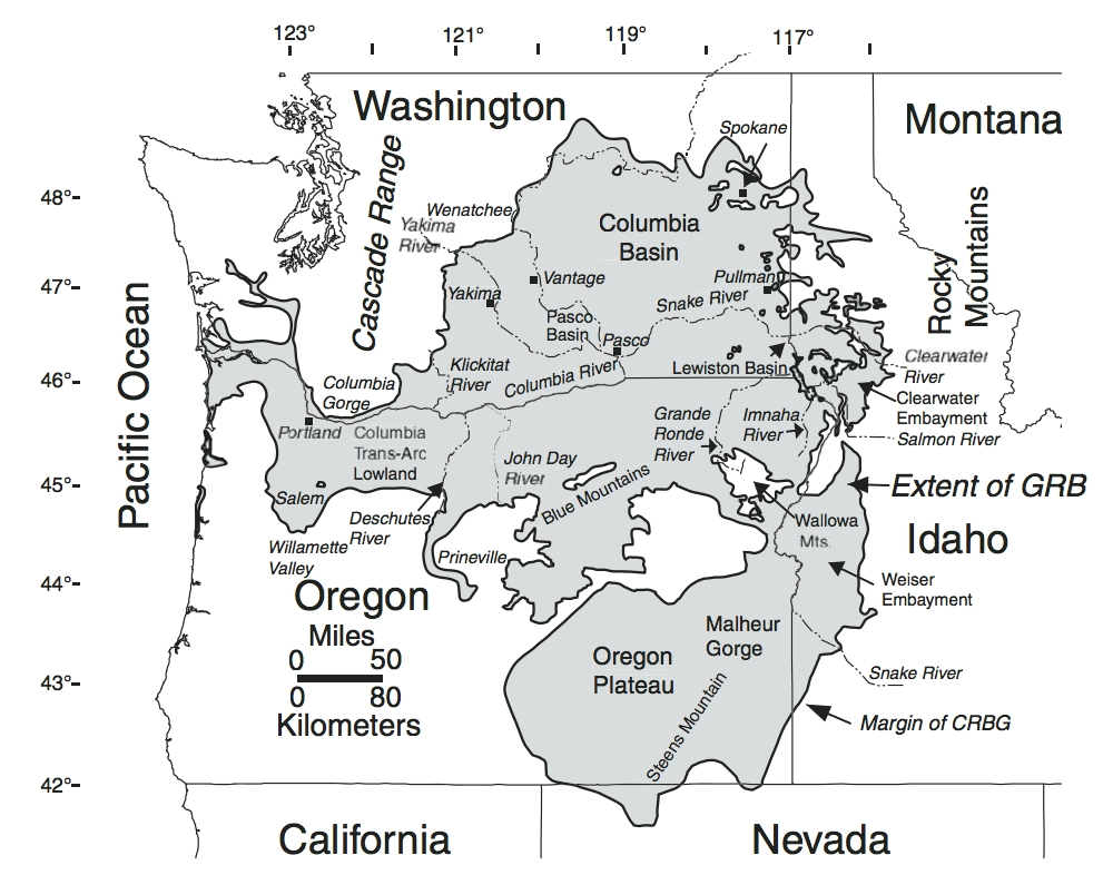
We came across an interesting article in IFLScience that pertains to our own Washington and Oregon backyard and might be of interest to our fans. Here’s a short excerpt from the article that goes much more in depth about the ramifications of past LIPs and the potential comparable effects of our current contributors to global climate change. Siberia, India, Southwest China, Ethiopia, and Yemen – dotted around the globe, there are areas that stand out, geologically speaking, from the rest of the world. Why? Because they’re large igneous provinces (LIPs): massive, sprawling regions of igneous rocks, formed tens or even hundreds of millions of years ago in volcanic eruptions so huge that they changed the face of the planet itself. “You have the potential for truly enormous eruptions, possibly up to 10,000 cubic kilometers erupted in a single event,” Leif Karlstrom, an Earth scientist at the University of Oregon, told PBS. “And that will happen repeatedly over the course of a large igneous province event.” “These lava flows blanket the earth, and they travel for hundreds of kilometers,” he explained. “The flow rate is so high that they are not cooling – [they’re] flooding the landscape, filling in topography, and forming a stack of basaltic rocks that can be kilometers thick.”So, what would an LIP eruption look like? Well, think of the biggest volcanic eruption you know. Krakatoa, maybe, which, when it erupted in 1883, was responsible for more than 35,000 deaths and could be heard as far away as Australia; perhaps Mount Tambora, whose eruption in 1815 was the largest in recorded history, sending ash raining down over thousands of kilometers in every direction and producing the so-called “Year Without a Summer” in 1816. Anything like that will do. Now scale that up by a factor of, oh, let’s say 10,000, and you have an idea of what a large igneous province event might look like. “A LIP is not a single dramatic event like Mount Pinatubo, or the explosive Mount Tambora eruption in 1815,” explained Stephen Grasby and David Bond, geologists at the Geological Survey of Canada and the University of Hull respectively, in a 2023 article for Elements magazine. Instead, radiometric dating “indicates that LIPs extruded lava flows over tens if not hundreds of thousands of years,” the pair wrote. “As such, LIP events are better thought of as a long series of many thousands of seemingly mild Laki-like eruptions, rather than a single massive explosive eruption.” “Mild” may be understating it. Laki, they acknowledge, is a volcanic fissure in Iceland which, when it erupted in 1783 and 1784, “decimated Iceland’s livestock and crops, leading to a famine that killed approximately a quarter of the island’s human population,” as well as “cool[ing] the Northern Hemisphere so much that crops failed and livestock across Europe was poisoned, leading to – according to some historians – the French Revolution.” In other words: an LIP event is akin to some of the biggest, most impactful volcanic eruptions – but if they simply never stopped erupting. And after a while, the world just can’t cope with such an onslaught. Read more
2025 IAFI YEAR-IN-REVIEW

We normally include a review of our past year’s activities in our January newsletter for our members and interested others, but that newsletter was just too overfull with other important news. Our 2025 Year-In-Review below was compiled January 30, 2026.This is our 9th year preparing a Year-in-Review report for you, our members. We appreciate your continued support, friendship and membership. INSTITUTE MEMBERSHIP – Our members provide most of our support and much of the reason for the various materials, activities and events we provide. In 1996, we started with 11 members. At the end of 2025, we have 583 members (446 memberships). Our members come from the following states: Washington (67%), Oregon (15%), Idaho (7%), Montana (5%) with smaller amounts from CA, NV, AZ, WY, TX, AK, NM and OK, Canada and Germany. INSTITUTE BOARD ACTIVITIES – IAFI work activities that occur at both the Institute Board of Director level and at the Chapter level generally benefit the entire organization. Listed below are some of these activities. The Board works closely with the National Park Service Program Manager for the Ice Age Floods National Geologic Trail. We have a formal partnership agreement and work cooperatively to further the missions of both organizations. The Education Committee, in partnership with IAFL-NGT and Engaging Every Student, has developed a curriculum program for our 4 state region, “Ice Age Floods Detectives”, of 4 one-hour lesson plans focused on a 4th grade audience. The Education Committee also developed a K-12 Grant program to provide funding to teachers and students for field trips, lab supplies, and to provide funds for other ancillary needs that will enhance implementation of the curriculum. The Cheney-Spokane Chapter established a Student Research Grant program that covers the entire institute area. It recently awarded its first grant The Membership Committee created a Floods Photo of the Week program which provides photos of features throughout the four-state area for all our members. Our webmaster keeps the website (iafi.org) fresh and stimulating. He also, with support from the chapters, issues the Pleistocene Post Newsletter four times a year. Our Membership Manager provides quarterly reports on member/memberships for all chapters and the institute. She responds to membership queries, resolves problems and keeps records current. Our IAFI Treasurer works with our Certified Public Accountant who maintains all our financial records and provides monthly reports to the Board. Our IAFI Store Manager provides service to our members by stocking and processing orders for the most recent books, maps, etc related to the ice age floods. ANNUAL MEMBERSHIP MEETING – This year the annual IAFI membership meeting and field trip was held hosted by the Columbia River Gorge Chapter and there. Approximately 146 people attended the event. Click here for a reflective review of the event. 2025 CHAPTER PROGRAMS – Outreach to inform and educate the public about the Ice Age Floods and their long-lasting impact on our area is a key part of the IAFI mission. Our local chapter programs are possibly the most effective way we meet this challenge. Three of the more important ways we help people learn about the Ice Age Floods are with lectures, field trips and hikes. LECTURES – In 2025 we had 37 lectures attended by over 1549 people. Many more people viewed lectures when they were posted on YouTube. FIELD TRIPS- In 2025 we conducted 22 field trips with 735 attendees. HIKES – In 2025 three chapters sponsored 7 hikes with 106 attendees. PRESENTATIONS TO K-12 STUDENTS Columbia River Gorge chapter – talk and 2 field trips for Hood River New School and a talk for Hood River Elementary 4th grade classes Cheney–Spokane Chapter – Jefferson Elementary School STEM Expo requested that the IAFICS Chapter staff an educational booth on the Ice Age floods. The booth was so popular with the kids and their parents that our chapter was asked to participate in a follow up at the Westview Elementary School STEM Expo. The IAFICS Chapter was contacted by Spokane City Councilman Zack Zappone, requesting a talk and short hike for the North Central Middle School. Lake Lewis Chapter – A number of members helped with education programs at The Coyote Canyon Mammoth Site (MCBONES) near Kennewick. Palouse Falls Chapter: talk and presentation to Pomeroy Home School. Lower Grand Coulee Chapter: Assisted with a presentation at the Ice Age Floods Fest at Dry Falls aimed at educating children on the Ice Age Floods story (350+ attendees). INVOLVEMENT WITH PROFESSIONAL ORGANIZATIONS AND UNIVERSITIES Cheney–Spokane Chapter – Dr. Isaac Larsen (Univ. Massachusetts), accompanied by a graduate student, requested a three-day field trip to collect flood ice-rafted erratics and in-situ exposure for exposure dating of the glacial floods in the Spokane and Vantage areas. Drs. Jim O’Connor and Lydia Staich (USGS) requested a two-day research field trip to look at historical till and flood sites on the Spokane Indian Reservation southeastward to Reardan and Spokane-Mica area. All chapters routinely recruit knowledgeable speakers from universities or state/federal agencies to ensure we are presenting the most current scientific information to our members. PRESENTATIONS AT COMMUNITY EVENTS Cheney-Spokane Chapter – Great Outdoor Sports Expo requested that the IAFICS Chapter staff an educational booth on the Ice Age floods. Don Chadbourne and nine enthusiastic chapter volunteers manned the booth which had heavy traffic on both days. Over 100 people stopped by the booth to get information on our upcoming events and pick up brochures providing information on local flood features and the National Geologic Trail. For the second year the Spokane County Library System asked the Cheney-Spokane chapter to provide speakers for four library branches. All four talks filled the rooms. The Turnbull National Wildlife Refuge asked the chapter to staff a booth and lead a hike. Columbia River Gorge Chapter – Gorge History Museum talk. Nature Conservancy talk at Rowena Crest . Co-led a number of field trips sponsored by the Columbia Gorge Naturalist Program. Coeur Du Deluge Chapter – Again led programs for the Idaho Master Naturalists. Interviewed for Sandpoint Magazine (Summer 2025). Ellensburg Chapter: had information booths at two Ellensburg Farmers Markets. Spoke with about
Introducing IAFI’s K-12 Education Grant Program
Empowering Teachers to Share the Ice Age Floods Story with Students Mini-grants of up to $500 now available for K-12 educators Open Application Period The Ice Age Floods Institute is proud and excited to announce a groundbreaking initiative to bring one of Earth’s most dramatic geological stories into classrooms across the Pacific Northwest. Our new K-12 Education Grant Program provides targeted funding to help teachers and students explore, understand, and share the remarkable Ice Age Floods narrative with their communities. The Challenge We’re Addressing The Ice Age Floods story may seem straightforward to those who’ve studied it, but explaining these catastrophic events to newcomers can be surprisingly complex. Teachers need effective guidance and quality materials to bring this geological phenomenon to life in their classrooms. Students who become fascinated by the floods can inspire others. IAFI recognizes that reaching K-12 students is one of the most effective ways to educate young people, and through them to share this incredible story with their families and communities. Our Mini-Grants Solution: Grants up to $500 That Make a Difference These carefully designed mini-grants help defray the costs of materials, field experiences, and project development for classroom instruction throughout Idaho, Montana, Washington, and Oregon. By providing this crucial support, we’re creating a ripple effect of interest and knowledge that extends from students to their families and friends. How Grants Can Be Used We’ve designed this program with flexibility in mind, understanding that teachers and students have diverse needs and creative approaches to sharing the Ice Age Floods story. These grants are meant to support classroom activities including curriculum materials, educational supplies, guest speaker fees, and field trip expenses to Ice Age Floods sites throughout the Pacific Northwest. The Power of Student Engagement When students develop genuine interest and excitement about the Ice Age Floods, they become natural ambassadors for the story. They share their enthusiasm with family members over dinner, explain geological concepts to friends, and carry this knowledge forward throughout their lives. This program doesn’t just fund classroom teachers—it creates a generation of informed advocates for geological education, research and preservation. What Makes This Program Special Our grant program initially focuses on 4th grade educators in support of the IAFI 4th Grade Curriculum Project. This strategic approach allows us to build a strong foundation before expanding to all K-12 teachers and students in future years. It’s For Educators Teachers can apply for funding to enhance their Ice Age Floods curriculum through: Classroom materials and educational resources Field trip expenses to visit actual flood-carved landscapes Hands-on demonstrations and interactive activities Professional development opportunities Some Useful Teaching Resources Big Water Is Coming (PDF) – A children’s book illustrating the possible reactions and impact on animals in the path of a Flood NPS-IAFloods Animated Video (narrated) – A short National Park Service animated and computer-voice narrated video about the floods NPS-IAFloods Animated Video (unnarrated) – The same short National Park Service animated video about the floods, without narration An Ice Age Floods Story Introduction – A brief teacher’s guide elementary grade-level introduction to the Ice Age Floods. Simple Application Process We’ve designed our process to be straightforward and educator-friendly. Applications are accepted year-round starting January 2026, with a two-month review period. Once approved, recipients have one year to complete their projects, followed by a six-month window to share their results with the IAFI community. Educators can use the online application below to get started. Join Us in Making Floods History Come Alive This Scholar Support Grant Program represents more than just funding—it’s an investment in geological literacy, scientific curiosity, and the preservation of our region’s remarkable natural heritage. By supporting teachers and students as they explore the Ice Age Floods, we’re ensuring that this incredible story continues to inspire wonder and understanding for generations to come. Get Involved – YOUR support directly impacts the next generation Whether you’re an educator ready to apply or a potential donor, an individual member, local business, organization committed to education, or simply curious to learn more, we invite you to be part of this exciting initiative. Contact us at IAFIGrants@gmail.com. And your donation will help ensure that more students and teachers can access the resources they need to share the Ice Age Floods story effectively. Donate tax-deductible and fee-free either through our Zeffy Fundraiser (***note: Zeffy’s “tip” request is optional***) or mail a tax-deductible donation directly to: IAFI K-12 Educator Grant Program, 1440 SW Brislawn Loop Rd. White Salmon, WA 98672. $5,000 Annual IAFI Program Funding Commitment and Growth The program is initially funded by the Ice Age Floods Institute and our 11 local chapters with a $5,000 annual commitment to support multiple projects each year. We’ve received over $1600 in additional donation support from IAFI members and the Bellevue Rock Club. Thank you all. We’re committed to continue growing this program through donations from IAFI members, businesses, educational grants, and other philanthropic sources. We anticipate significant interest from current members and believe that a successful grant program will help attract new supporters to IAFI’s mission. Grant Cycle Applications will be accepted on an ongoing basis. Grant awards will be approved and announced within 2 months of application and 90% of an grant will be awarded upon approved. The awarded grant must be used and a final report shared with IAFI within 12 months – the final 10% of of the grant will be awarded after completion of these requirements. Questions? Email us at IAFIgrants@gmail.com
Free Educators Workshops: Bringing the Ice Age Floods Story to Classrooms
Every student in the Northwest should experience the incredible science story of the megafloods that shaped our landscape and history. To help bring this story to life, the Ice Age Floods Institute, Engaging Every Student, and our partners are excited to invite K–12 educators to free special training events. Thanks to support from the Avista Foundation, we are offering free hybrid workshops where you will gain access to valuable resources designed to inspire students to investigate their local environment.
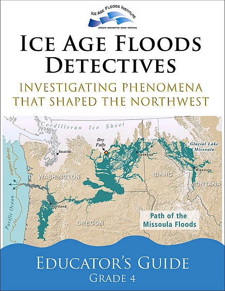
Telling the Story of the Missoula Floods
Developing an Ice Age Floods Animation Through Science, Partnership, and Interpretation Explaining the Missoula Floods has never been simple. The floods reshaped landscapes across much of the Pacific Northwest, yet they occurred thousands of years ago, unfolded repeatedly rather than once, and operated on a scale that is difficult to grasp from any single viewpoint. While physical evidence of flooding is visible in coulees, erratics, and sediment deposits across the region, understanding how those features formed requires connecting processes that span vast distances and long periods of time. For the Ice Age Floods National Geologic Trail, this challenge sits at the center of its mission. The Trail links flood-related sites across four states and relies on partnerships with parks, museums, educational institutions, Tribes, and communities to interpret a story that is regional in scale and national in significance. Developing a shared, accurate way to tell that story has been a long-standing goal. One important step toward that goal is the release of a new Ice Age Floods animation, now publicly available through the Pleistocene Post for the first time ever through the National Park Service and the Ice Age Floods Institute. Understanding the Missoula Floods—and Why Animation Was Essential The Missoula Floods were not a single catastrophic event. They occurred dozens of times as an ice dam repeatedly formed and failed during the last ice age. Each flood released immense volumes of water, carving the Channeled Scablands, transporting massive boulders, and depositing thick layers of sediment across the Columbia Basin, the Willamette Valley, and beyond. These repeated events reshaped landscapes on a scale that is difficult to grasp from any single location or landform. This combination of repetition, scale, and process presents a fundamental interpretive challenge. Static maps, photographs, or diagrams can show where flooding occurred, but they struggle to convey where ice dams formed and failed, why floods happened repeatedly, and how those repeated events shaped the landforms we see today. Visitors often encounter individual features—such as coulees, erratics, or sediment deposits—without an intuitive sense of how those features connect to a larger, system-wide story. Animation offers a way to bridge that gap by showing movement, change, and sequence over time. It makes it possible to illustrate how ice dams failed, how floodwaters moved across vast landscapes, and how erosion, transport, and deposition shaped the region over thousands of years. By showing sequence and scale together, the animation provides context that static interpretation often cannot. At the same time, animation carries risks. Visual storytelling can unintentionally oversimplify complex processes or imply certainty where scientific understanding includes ranges and ongoing inquiry. Addressing those risks required careful collaboration and review to ensure the final product communicates current scientific understanding clearly, accurately, and responsibly. A Trail Built on Partnership The Ice Age Floods National Geologic Trail is a partnership-based unit of the National Park Service. Unlike traditional national parks, the Trail does not center on a single land base. Instead, it connects a network of sites, organizations, and communities that collectively interpret the Missoula Floods story across four states. From its earliest days, scientific research and public education about the floods have been advanced by regional partners, particularly the Ice Age Floods Institute, along with academic researchers, museums, educators, and land managers. Federal agencies with expertise in geology, hydrology, and landscape science have also contributed to the evolving understanding of flood processes and landforms. Together, these partners built the scientific foundation and public awareness that ultimately made the Trail possible. That shared foundation shaped how the Ice Age Floods animation was conceived. The project was not approached as a standalone National Park Service product, but as a collaborative effort intended to reflect current scientific understanding while respecting decades of research, publication, and public engagement. Partner involvement helped ensure the animation was grounded in credible science and responsive to the needs of educators, interpreters, and institutions working across the region. Just as important, partners helped shape how the animation would be used. From the outset, it was understood that no single product could replace place-based interpretation. Instead, the animation needed to complement local stories, support diverse interpretive goals, and function as a shared framework rather than a prescriptive narrative. The result is an animation designed to be flexible, modular, and broadly applicable. A Collaborative Development Process Developing the animation was an iterative process involving scientists, interpreters, educators, and media specialists. Expertise in glacial dynamics, flood hydraulics, geomorphology, and interpretation informed each stage of development, ensuring that both scientific rigor and interpretive clarity remained central throughout the project. Drafts were reviewed not only for technical accuracy, but for how audiences might reasonably interpret what they were seeing. Revisions focused on clarity and defensibility—refining pacing so that scale was conveyed without exaggerating velocity, ensuring viewers could distinguish between process and outcome, and reinforcing that the floods occurred repeatedly rather than as a single event. In many cases, refinements were not about correcting facts, but about improving how those facts were communicated visually. The goal was not to resolve every scientific nuance, but to present a version of the story that is accurate, carefully framed, and useful across many interpretive settings. This collaborative approach helped ensure the animation could serve as a reliable interpretive tool while remaining accessible to broad public audiences. What the Animation Is—and Is Not The Ice Age Floods animation is intended to provide a system-scale overview of how the floods worked, support education and interpretation across diverse settings, and serve as a shared visual reference for partners and educators. It is not intended to replace place-based interpretation, resolve all scientific debates, or function as a comprehensive instructional resource on its own. In many cases, individual segments of the animation may be more useful than the full piece. Short sections can illustrate specific topics—such as basalt erosion, flow through constricted valleys, or the cumulative effects of repeated flooding—while local interpreters focus on the features and stories most relevant to their sites. Supporting Education and Public Understanding Now that the animation is publicly available, it
IAFI Store – Winter Inventory Reduction Sale

The IAFI Store is having a special Winter Inventory Reduction Sale to make room available to add new items and updated items as they become available. This is a great opportunity to get Floods-related presents for family, friends, and maybe yourself at (often) steeply reduced prices. And every order will include a free IAFI window decal you can use to let others know you’re passionate about the features and the science behind the cataclysmic Ice Age Floods story. Share the Ice Age Floods story this Christmas! The IAFI Store’s Winter Inventory Reduction Sale is here – and it’s your chance to dive deep and share the story of these spectacular events. We’re making room for exciting new items, which means steep discounts of 10% to over 40% on a selection of Ice Age Floods merchandise. Whether you’re shopping for the Floods enthusiast in your life, a curious student, or treating yourself to something extraordinary, now’s the perfect time to explore the fascinating world of the cataclysmic floods that carved the Pacific Northwest. What Makes This Sale Special? From educational materials that bring ancient catastrophes to life, to unique gifts that celebrate the power of water and ice, our collection offers something for every curious mind. These aren’t just presents – they’re gateways to understanding the massive forces that shaped our landscape thousands of years ago. As an added gift for you, every order comes with a free IAFI window decal – your badge of honor showing you’re passionate about the incredible science behind the Ice Age Floods story. It’s more than just merchandise; it’s a conversation starter about one of the world’s most dramatic chapters. Limited time only. Shop now while inventory lasts and discover why the Ice Age Floods continue to captivate scientists and nature lovers alike. Ready to explore? Visit the IAFI Store today and turn this Christmas into a journey through deep time.
The Pulse of Rocks

“All creatures, objects, places, and elements have a spirit.” Patrick Saltonstall, Sugpiag (Aleut) Are rocks alive? Hmm. You might be visualizing a small stone or large boulder just sitting there…doing nothing. If life has to originate from a cell, then a no vote seems reasonable. Let’s give the Mineral Kingdom a few minutes to speak on behalf of its constituents: “Our rocky friends react to temperature, expand and contract; they can absorb moisture, and they can transform their makeup entirely, like petrified wood changing into stone. Taxonomy – In the 19th . century, rocks and minerals were first classified based on their chemical make-up. As with animals and plants, new members are added yearly to the mineral kingdom’s nearly 10,000 species. Movement – Rocks sure move around, from riding glacier waves, to being catapulted for miles out of fiery volcanoes to being gently tumbled downstream by…streams, and through time, broken down into sandy beaches. Or, if you’re pumice, you can simply float downstream at your leisure. Any pebble has placed many travel stickers on its luggage finding itself in many lands during its long life. Stalagmites and stalactites check off another life form requisite by respectively growing up and down in caves with the help of slowly dripping water. Rock serves us well in concrete, road building materials, sculptures, and stone homes, all making us Salt of the Earth. Reproduction and Growth – Kidney stones are minerals and salts formed in urine. They form and grow in the bladder and kidneys. The imbalance of too many minerals in the urine and not enough liquid causes the minerals to reproduce and grow. Cooperation – Practically all living things rise out of soil, which is a mixture of organic and inorganic magic. Plants need both. Animals need minerals too. Salty seas cover a major chunk of our planet providing a swimming pool habitat to countless known and still to be known species Awe Inspiring – Rocks are the basis for our most beloved national, natural treasures, from the timeless Grand Canyon, to Yosemite’s granite walls, towering Mt. Rainier, the sandstone Arches, and the Grand Tetons, among many others. We are moved to witness sunrise and sunset light beaming red, and filtered white on mountain peaks. We climb boulders; we summit mighty bare rock and snow-covered mountains for the view, for the peace, perhaps for the love, too. The Fine Line – Everything that is living on our precious planet originated with and within the rocky world, making it a challenge to separate the line between non-life and existence. We are made of stars. We are made of star spirit. A wildlife biologist/naturalist reflects on lithologic ‘life’, Bill Weiler, January 2026
K-12 Ice Age Floods Curriculum: Floods in the Classroom
Thousands of K-12 students across the Pacific Northwest are becoming Ice Age Floods detectives—investigating ancient catastrophic flooding, conducting hands-on experiments, and sharing geological discoveries with their communities. Some may be inspired to become scientists who will ask new questions and conduct research that will advance our understanding of these ancient megafloods. This transformation is happening through Ice Age Floods Detectives, a new grade school science curriculum funded by the Ice Age Floods Institute (IAFI) and developed through partnership with the Ice Age Floods National Geologic Trail (NPS), and Engaging Every Student. The Ice Age Floods Detectives program is comprised of four phenomena-based ~1-hour lessons, targeted to grade 4 but adaptable for grades 3–8, to be taught in order over a week or more. Lesson 1: Modeling Ice Age Floods Erosion. Students create watershed models to visualize how water flows and reshapes the landscape. Lesson 2: Investigating Deposition. Students observe how different rocks and landforms are created by deposition, connecting these small-scale experiments to the massive scale of the Ice Age Floods. Lesson 3: Creating Kinesthetic Classroom Models. Students use physical movement and simple materials to model incredible scale of Ice Age flooding, weathering and erosion. Lesson 4: Exploring the Erosion Energy of Moving Water. Students experiment with water speed and volume to understand its erosive forces and to practice designing scientific experiments. Students will explore the scientific processes geologists use to make discoveries, and how the fascinating area of science—like most other disciplines—is dynamic and constantly changing. The lessons help students explore phenomena and investigate how they relate to observable geologic features. Students are gradually introduced to concepts, processes, and theories that will assist them in forming and revising their own explanations and hypotheses about the Ice Age Floods. These adaptable lessons help train students to be good scientists and critical thinkers, with a unifying theme of exploration and investigation. When the lesson plans are delivered in sequence, a storyline develops, using the creation of our NW landforms as a compelling framework to help cover core concepts and improve student skills. Numerous studies have identified the need for improved STEAM (Science, Technology, Engineering, Arts, Mathematics) education that connects to students’ lives and communities. Research indicates that grades 4-6 are particularly critical for engaging students and encouraging them to pursue STEAM fields. Those grades are a particular focus of the program, which will help us address the critical need for more scientists and engineers. The curriculum complies with Next Generation Science Standards + Common Core State Standards, and should not compete with other curricular goals for classroom time. This program updates and complements the earlier NPS Investigating Ice Age Floods K-12 curriculum. We’re bringing this curriculum to educators throughout Washington, Oregon, Idaho, and Montana through regional workshops. Ice Age Floods Institute has also established an IAFI K-12 Education Grant Program to help educators offset attendance costs and classroom implementation expenses. You can also help support the program and play a significant part in inspiring the next generation of scientists: Donate fee-free through our Zeffy Fundraiser or IAFI Gorge Chapter’s PayPal Giving Fund Share information and leads about potential funding sources— contact us at IAFIGrants@gmail.com Share this flyer with educators in your community to help spread the word
Malaga Landslide: Ice Age Catastrophe Along the Columbia River
The east bank of the Columbia River near Malaga, Washington, is home to one of the largest and most visually striking landslides in the Pacific Northwest: the Malaga Slide. Covering an estimated 45 square miles, this massive slope failure poured weakened basalt and sediment into the Columbia River valley at the close of the last Ice Age. Today, it remains easily visible from State Route 28, making it an accessible outdoor classroom for geology enthusiasts and tour participants. The geologic story of the Malaga Slide is a tale of both slow preparation and sudden catastrophe. Layers of basalt from the Columbia River Basalt Group were fractured and weathered over millions of years. Interspersed with weaker sedimentary layers, these formations became prone to failure. Add in groundwater saturation, the erosive power of repeated Ice Age Floods, and over-steepened valley walls, and the stage was set for a massive collapse. Scientists believe the main phase of the Malaga Slide occurred approximately 15,000–13,000 years ago, during the final stages of the Missoula Floods. While the collapse itself was sudden, the landslide likely continued to adjust and move over time, creating the hummocky terrain and displaced boulders still visible today. One of the most intriguing aspects of the Malaga Slide is its interaction with the Columbia River. Some geologists have hypothesized that the massive slide may have temporarily blocked or partially dammed the river. This could have caused short-term ponding upstream, potentially extending back toward Peshastin. Evidence of this interaction remains visible today as enormous boulders and slide debris in the river channel. Travelers heading south from Wenatchee on State Route 28 are treated to a dramatic view of the slide, with scarred slopes and scattered boulders lining the west side of the river. This visibility makes the Malaga Slide an outstanding site for guided geology tours offered by the Wenatchee Valley Erratics Chapter of the Ice Age Floods Institute. Participants learn about Ice Age Flood processes, landslide mechanics, and the long-term evolution of the Columbia River valley. Learn more about Wenatchee-area geology tours: https://wverratics.org or contact@wverratics.org Article by Jeff Becklund, Wenatchee Valley Erratics Chapter President