GLM Chapter Adds to the “Route of the Rocks”
Members of the Glacial Lake Missoula Chapter recently placed two more rock markers on recreation trails located on Missoula hillsides. Both rocks were placed at 4200 feet elevation, the highest fill level of the Lake. The inscription contains IAFI’s name and logo, Glacial Lake Missoula, and the high-water elevation of 4200 feet. The rocks (known as #6 and #7) continue the “Route of the Rocks” project of previously placed rocks throughout the Missoula area. Most of the rocks are situated at 4200 feet. Missoula’s elevation is about 3200 feet, so trail users can imagine the valley completely submerged with only the highest surrounding hill tops sticking out. Number 6 is located on the Miller Trail which begins at the Little Park Creek Trailhead and parking lot, accessed via upper Miller Creek Road. Hiking distance is approximately 1.5 miles. Number 7 sits at 4200 feet on Marshall Mountain, a former ski area but now a park, in East Missoula. From the parking lot take the Easy Up Trail .6 mile to the rock. The rocks are either argillite or quartzite from the Belt Formation. An interactive trail map of the Missoula area can be found at https://missoulamaps-cityofmissoula.hub.arcgis.com/datasets/missoula-trails
NORM SMYERS, AUGUST 10, 1943-APRIL 1, 2026
Norm Smyers, 82, of Missoula, Montana, passed away at home on April 1, 2026. During the past 30 years Norm has been actively involved in the formation, direction and leadership of the Ice Age Floods Institute, and in his local Glacial Lake Missoula chapter, all of which gave him immeasurable satisfaction and pride. Born Norman Bernard Smyers and raised in Hawthorne, California, Norm loved the beach, raced his bicycle all over the South Bay area, hiked and explored the nearby mountains and deserts. He realized at a very young age that he wanted to be a geologist, a goal likely arising from family camp trips to the eastern flank of the Sierra Nevada where landforms, rocks, and fossils captivated his curiosity. He graduated from California State College, Long Beach, followed by an MS in geology from CSU, San Diego, and much later, an MA in anthropology (his “retirement” degree) from University of Montana (always a lifelong learner). His career began with teaching high school science and math in Torrance, California, interspersed with several enjoyable summers working as a ranger/naturalist at Crater Lake National Park, Cape Perpetua/Siuslaw National Forest, the Ancient Bristlecone Pine Forest/Inyo National Forest, and Bryce Canyon National Park. For thirty years, he held geologist positions with the US Geological Survey, US Bureau of Land Management and US Forest Service in California, Nevada, Colorado and Montana. He also served on the Target Range Sewer and Water Board, participated in Five Valleys Audubon, and enjoyed cruising in his ’47 Ford and ’85 Corvette with local car clubs. On May 14, 2026, friends celebrated Norm’s life on the banks of the Clark Fork River, a remnant of Glacial Lake Missoula, where his ashes happily wafted, settled and mingled with the sediments. RIP Norm, your life and contributions are remembered fondly and with great respect for all you have done. He is survived by his wife of 56 years, Cathryn, his companion dog Paco, and many friends and admirers.
Rehoming Wenatchee Valley Erratics Chapter
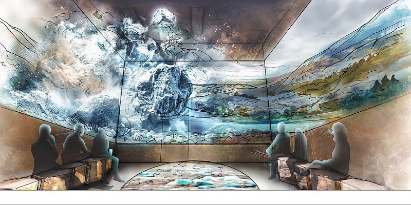
Our Wenatchee Valley Erratics Chapter home for many years at Wenatchee Valley Museum and Cultural Center is now officially closed as of May 18th for a huge renovation project. With that news, now begins the relocation of our chapter’s Education Dept. (i.e., Chapter Headquarters) to the Wells House. We will have our Presentation Area, Internet and Equipment ready in July in time for our August presentation, which is sure to be a reward for our patient Chapter members. The Wells House will provide a historic setting and venue although quaint. The Wenatchee Valley Museum & Cultural Center has long been a place where the history, culture, and creativity of our region come alive. Yet today’s visitors need more than the museum’s current facilities can provide—easier access, more engaging spaces, and opportunities to connect across generations and cultures. The “Branch Out” campaign is Wenatchee Valley Museum & Cultural Center’s answer to that need. By reimagining our campus with connected buildings, welcoming gathering areas, and interactive exhibits, we will create a destination that reflects the energy of our growing community and ensures these stories are preserved, shared, and celebrated for decades to come. Take a virtual fly-through of the new museum design. Relive the joy of the project groundbreaking event. Support the Museum & Cultural Center’s Branch Out building fund campaign. Donations will be matched until June 30th by the Wiedner Group. The Wells House has a long and varied history in Wenatchee. From its construction in 1909, it had been used as family residences, junior college girl’s dorms, administration offices, early classrooms and student activities. It was rescued from demolition and placed on the National Register of Historic Places in 1973, before being deeded to the Museum with the goal of preserving and maintaining it so that it can be used and enjoyed by the public, raise awareness of our valley’s history, and be an architectural asset that contributes to a sense of place and pride within our community.
Remembering Stev Ominski
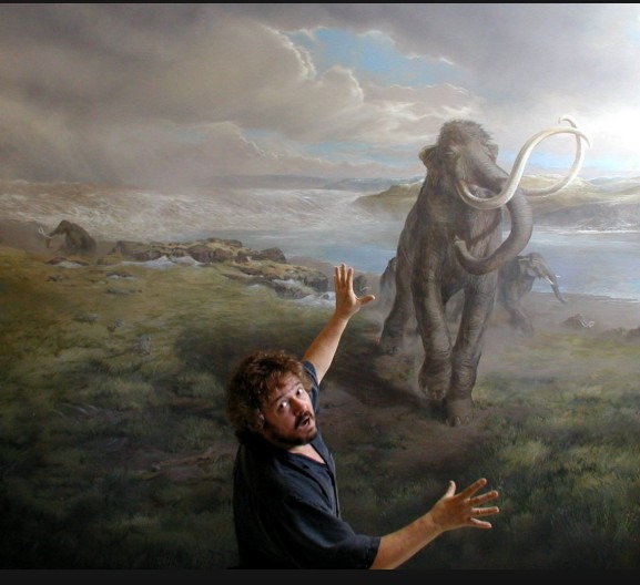
Stev Harvey Ominski, 74, passed on Sunday, May 24, 2026, from stroke complications. Stev created illustrations rendering visual imaged to the Missoula Ice Age Floods that have been included in numerous publications from the Oregonian to the New York Times. A traveling collection of his Ice Age Floods work was exhibited at the U of O Museum of Natural and Cultural History (Eugene), the Columbia River Exhibition of History Science and Technology (Richland, WA) and The Discovery Center (The Dalles). Painting to Stev was like breathing. Just something he did daily. Primarily self-taught, Stev began his professional career in the fine arts in 1970 with emphasis on intimate landscapes and other subjects from the natural world. He worked in the mediums of pencil drawing, watercolor, acrylic, and oils. He showed in numerous exhibitions in galleries and museums and was included in group exhibits at the Portland Art Museum as well as OSU’s Art about Agriculture and Seeing the Forest. He was especially proud of his work at the Salem Public Library, Salem Pediatric Clinic, Salem Cardiology Clinic, Albany Hospital and Louisiana Pacific. Stev wrote and illustrated “Nature Notes” a weekly nature column for the Salem Statesman Journal. He taught watercolor at Chemeketa Community College. Stev enjoyed exploring the outdoors, especially creeks and streams and casting one of his hand tied flies for trout in coastal streams. Cooking was another art to which Stev acquired the requisite skills to serve tasty and filling meals. One hand held a glass of wine while the other stirred the pot. Music was a big part of his life. Especially the Beatles, and specifically George Harrison for his introspective qualities. But his artistic generosity and ability to bring the immensity of the Ice Age Floods to life is something we’ll be ever indebted, grateful and appreciative of. If you’d like, you can make donations in his memory to the Ice Age Floods Institute at IAFI, c/o Monte Nail, 1880 Fowler St., Richland, WA 99352 The IAFI Store has a limited stock of Stev’s Ice Age Floods images available for purchase. Stev was very picky, personally supervising the prints for sizing, cropping, depth of colors, matting and signing, so when our stock is sold out they cannot be reordered.
Fueling Yellowstone’s Supervolcano: A New Tectonic Twist
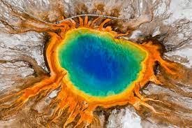
New research suggests that the Yellowstone supervolcano may not be fueled by a deep “mantle plume” as previously believed. Instead, a study published in Science suggests that the volcano’s activity is driven primarily by tectonic shifts within Earth’s crust. The New “Plumbing” Model For years, scientists debated whether Yellowstone was heated by a deep column of hot rock rising from the Earth’s core. However, researchers using 3D modeling discovered that the magma system is actually controlled by two competing tectonic forces: Crustal Stretching: The lithosphere (outer crust) is being pulled toward the U.S. West Coast. Sinking Plates: An ancient tectonic plate, the Farallon slab, is sinking beneath North America, dragging the lower crust downward. This “tug-of-war” pulls the lithosphere open, allowing magma to migrate from the southwest to the northeast and rise toward the surface. This discovery is a game-changer for volcanic forecasting. By understanding that tectonics—rather than a deep plume—fuel the system, scientists can better predict how the volcano will behave as it moves toward the thicker, colder crust to the east. “Our work changes the understanding of how the magma plumbing system works, so future eruption models have to take this into account.” — Lijun Liu, Geologist at the Chinese Academy of Sciences. This tectonic modeling isn’t just for Yellowstone. It could help researchers better understand other high-hazard systems, such as Toba in Southeast Asia and Taupo in New Zealand, potentially improving volcanic safety worldwide. From an article in LIve Science by Sarah Wild
Ice Age Floods National Geologic Trail Update – April 2026
Hello from the Trail. Spring is bringing renewed energy across the Ice Age Floods National Geologic Trail, and I am pleased to share several updates on ongoing work and collaborations that continue to strengthen how we tell the floods story with our partners. Trail Brochures Heading Out Across the Region The National Park Service recently placed an order with the Government Publishing Office for a new printing of Trail brochures. A total of 21,600 brochures will be distributed to twenty-eight partner organizations across the four-state region. These partners play an essential role in delivering high-quality flood information into the hands of visitors, educators, and residents who want to explore this remarkable landscape. Supporting Long-Range Planning for the Trail Work is underway with planning staff from the Pacific West Regional Office and the Denver Service Center on a Preliminary Planning Project. This early planning effort will allow the National Park Service to begin shaping a more comprehensive management approach for the Trail and ensure that long-term needs and partner expectations are built into future planning conversations. Teacher Workshops and Educational Partnerships The National Park Service is proud to continue partnering with the Education Committee of the Ice Age Floods Institute. The Institute has taken the lead in organizing teacher-training workshops, developing a new fourth-grade curriculum, and launching a grants program to help school districts adopt it. The Institute’s leadership on these efforts is making a measurable difference in how young learners across the region are introduced to the Ice Age floods. New Interpretive Animation The NPS Ice Age floods animation released in January brought a new tool to communities, educators, and interpreters, and we are already hearing excellent feedback. Many partners have found creative ways to use the animation in public programs, museum settings, classrooms, and community presentations. I want to extend sincere thanks to the members of the Ice Age Floods Institute for their support throughout the development of this tool. Its value is clearly demonstrated by how widely and enthusiastically it is being used. Exploring New Technology for Interpretation and Data Sharing The Trail is in the early planning stages of two technology-focused efforts with the National Park Service: Natural Resource Stewardship and Science, Inventory and Monitoring Program. The first is a potential condition assessment to help the Trail better understand the state of key flood features. The second is an exploratory effort to determine whether AI-generated three-dimensional mapping could improve how geologic information is organized and shared. At the Institute’s most recent board meeting, I presented work from Terrain 360 to help illustrate what innovative visualization tools can offer. We will continue to coordinate discussions among subject matter experts and content developers to explore new ways to organize and present data, information, and interpretation related to the Trail. Thank you to the Institute’s members, volunteers, and partners for your continued dedication to the story of the Ice Age floods. I look forward to seeing many of you out on the Trail in the months ahead. Justin Radford National Park Service Ice Age Floods National Geologic Trail
A Landscape of Transitions

On a cool morning in late March 2026, a group of 16 curious field trip participants stood atop a scenic viewpoint in Richland, Washington looking out over the Pasco Basin, with the Yakima and Columbia Rivers silently flowing below. George Last, a local geologist and field trip leader for the Lake Lewis Chapter of the Ice Age Floods Institute, was explaining a sequence of geologic events that shaped the region surrounding the Tri-Cities. Massive lava flows filled the Columbia Basin with layers of basalt thousands of feet thick. The successive flows combined with tectonic forces uplifted and formed the anticlines along the local section of the Olympic-Wallowa Lineament – on clear display here as a chain of large rolling hills stretching from Rattlesnake Mountain to our northwest to the Horse Heaven Hills southeast of our vantage point. Ancestral rivers, responding to the changes in topography, changed courses across the landscape, cutting new routes towards the Pacific Ocean. Finally, a series of cataclysmic ice age floods roared in from its northerly source, backing up behind the natural constriction of Wallula Gap to form temporary Lake Lewis. The hilltop we occupied would have been completely overtopped by over 400 feet of debris-laden floodwaters. As we looked out onto this geologic foundation, a different landscape emerged in every direction. Our hilltop is capped by a community park. Below us, and along the hillsides of the looming anticlines nearby, the shrub-steppe slopes are blanketed with view-lot homes. Spreading out all around us is a fabric of roadways, housing developments, and commercial and industrial zones. Stretching out to the horizon are the irrigated fields, vineyards and orchards that have been an economic staple of the region since the early days of frontier settlement. Throughout the remainder of our field trip, this juxtaposition of human settlement and natural history is ever-present. A vacant lot, surrounded on three sides by a housing development, hosts an outcrop of the Ringold formation, deposited from the ancestral Columbia River or its tributaries between 3.4 and 8.5 million years ago. An 8.5 million year old basalt flow and Ice Age flood deposits ranging from 780,000 to 220,000 years old lay exposed at various abandoned quarries and borrow pits along our route. Unfortunately, several Ice Age Floods features, previously accessible, are now sequestered behind no trespassing signs or have been lost entirely to new construction. Many participants share stories of excavators uncovering a behemoth of a glacial erratic, to be methodically broken down by hydraulic hammer and hauled away to parts unknown. The final stop on the tour was the Coyote Canyon Mammoth Site outside Kennewick, operated by the MCBONES Research Center Foundation. The site is an active paleontology dig of a Columbian Mammoth, buried in late Pleistocene Ice Age flood deposits and loess. While our guide explains the methodical process of documenting each discovery, tour participants gaze upon a half-buried mammoth bone. One day this fragment will be fully exhumed after resting high in the hills for 17,500 years. It is interesting to think that, like those long buried erratics, this nearly complete skeleton may never have been discovered if not for someone searching with a shovel. It is stories like MCBONES that remind us that amid all of the re-grading, paving, and backfilling, there are stories of discovery and preservation to be shared as well. Conservation and education organizations, in the Tri-Cities and other communities across the Ice Age Floods National Geologic Trail, work tirelessly to preserve natural areas, establish trail networks, and erect educational markers calling attention to the wide variety of plants, animals and geologic features across the landscape. As development continues to expand across this region, the challenge lies in recognizing that the ground beneath our feet is not just a foundation for homes and infrastructure, but a record of deep geologic time and discovery. By fostering a balance between growth and preservation, and by supporting education, research, and access to these remarkable features, we ensure that the stories written in stone–from ancient lava flows to Ice Age floods–remain visible, accessible, and meaningful for generations to come. By John Young, Lake Lewis Chapter of Ice Age Floods Institute
Ice Age Floods Detectives – The Dalles Workshop Report
Every student in the Northwest should experience the incredible science story of the megafloods that shaped our landscape and history. To help bring this story to life, the Ice Age Floods Institute, Engaging Every Student, and our partners are excited to invite K–12 educators to free special training events. Thanks to support from the Avista Foundation, we are offering free hybrid workshops where you will gain access to valuable resources designed to inspire students to investigate their local environment.
Missoula Floods Feature – A Site of Mammoth Proportions
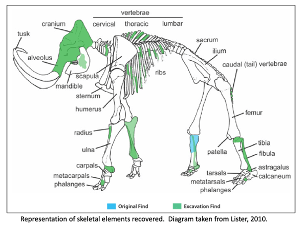
It has been well proven that the Missoula Floods greatly impacted central Washington and there are many examples of the magnitude of the floods, its reach, and dynamics. However, there is still debate on the number, size and timing and dating of these events. What is also less well known are some of the casualties of the floods. At least one feature is helping to tell the story of some of the last floods to grace the landscape. In 2015, a mammoth was discovered at Tonnemaker Hill Farm along the north edge of the Frenchman Hills in Grant County, Washington. Luke Tonnemaker was plowing up an alfalfa field when he made the discovery. Intensive study of the site was led by geologist George Last, paleontologist Bax Barton, local soil scientist and geologist Mark Amara, Gary Kleinknecht, education director, from the MCBONES Research Foundation, a volunteer excavation crew from MCBONES and the Tonnemaker family. The researchers coordinated with farm co-owners, Luke and his father, Kole Tonnemaker, and their wives Amanda and Sonia respectively, to professionally excavate, stabilize retrieved mammoth bones, identify as many bones as possible, and recreate the geology and history of the site. Mammoth remains are not that uncommon in Washington with several hundred animals discovered in the state, though fewer than 100 of those discoveries are located in eastern Washington. What is significant about this mammoth site is that it is one of the few finds that has received this much intensive study. Over 130 bones and bone fragments from a single Columbia mammoth were recovered with about 69 specimens identified. The animal was estimated to be between 25-30 years of age based on characteristics of its dentition, and it even lived with a damaged rib which had healed. George Last prepared diagram The presence of three distinct volcanic ash (tephra) layers and soil analyses suggests that at least four different Missoula flood event episodes are represented in the sediments beneath the mammoth bone bed. Dating of the site revealed that the animal post-dated identified Mount St Helens tephra eruptions that deposited ash in distinct horizons below the bones in water borne deposits. Dates associated with ash samples identified at WSU confirmed two of the layers correspond to Mount St. Helens S series while the topmost tephra shows some compositional variability but had similarities to the J or S series. Tephra ages ranged roughly from 14,000-16.000 years ago. Further dating through Utah State University was provided by optically stimulated luminescence (OSL) samples which gave dates ranging from 16-19,000 years ago. Since the bones are above the highest tephra and OSL sampling sites, the find is definitely younger than 16,000 years ago and was on the edge of one of last Pleistocene Missoula floods slack water lakes to cover this part of Washington. These conclusions were corroborated by analyzing the stratigraphy of the site and describing the soil which confirmed environments of deposition. Since the bones were above the aforementioned tephra layers and OSL sampling locations, and are at the interface of apparent windblown silts and Missoula floods slackwater deposits, it is still unclear how and when the animal died. However, the co-location of the mammoth remains with apparent ice-rafted erratic cobbles and boulders in fine-grained Missoula flood sediments, supports interpretation that the mammoth could have been carried in and left behind by a late breaking Missoula flood. Alternatively, it could have become mired in the mud along the shoreline and/or was killed by predators or even died in a subsequent drier period. Still the intensive studies to date have shown that this is an area with unique geologic history, one that is still unfolding. The Tonnemaker family has the recovered bones on display at their farm store and annually, including 2026, hold tours of the mammoth site during the Othello Sandhill Crane Festival held in March each year. There are a variety of papers, poster presentations and articles published or defended at meetings held by the Northwest Scientific Association and Geological Society of America, and a final report of findings between 2016-2024, with summaries highlighted, is available for viewing at the farm. Article by Mark Amara, Geologist, IAFI Lower Grand Coulee Chapter
A Drone’s Eye View of the Channeled Scablands
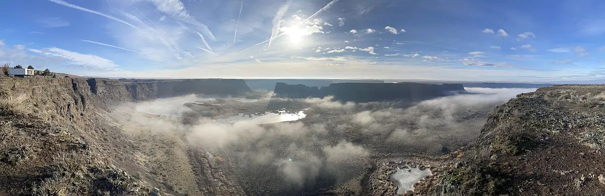
Without aerial views of the Ice Age Flood lands, we would still be debating the origins and nature of these features. Satellite and aircraft photos provide a broad overview of the channeled scablands, but in recent years, drones have given us a low-cost tool for close-up aerial photography. The detailed close-up view of the scablands showcases not only the region’s geology but also its incredible beauty. When I first saw Twin Lakes at sunrise, with the ethereal sight of fog rising from the lakes, I realized drones can help bring the scablands to the public. The dry cataracts at Potholes Coulee are another stunning feature not visible from the Ancient Lakes Trailhead but accessible by small aircraft. The trailhead is a popular starting point for exploring the coulee, with a rugged trail leading to the remnant cataracts that overlook the Columbia River. When the drone turned around and the dry falls came into view, I was awed by the cliffs towering over Babcock Bench. The photos tell a story of raging floods and giant waterfalls that have been silent for thousands of years. Lakeview Ranch (North of Odessa, WA) tells another story. The floodwaters flowing down Lake Creek Coulee spread out in this area, carving a random, chaotic landscape as they entered Crab Creek near Odessa. Bob’s Lakes, central to this area of chaos, are a central feature of this terrain, and the surrounding buttes and cliffs stand as a testament to the flood. A short distance to the northeast of Lakeview Ranch (on state road 21) is an excellent collection of structures called kolks, also called potholes. These are circular depressions drilled out by vortices in the flood waters and are not obvious from the road. All of these channeled scabland features are paradoxically difficult to see from ground level! The first time I flew a drone over Coffeepot Lake, part of the Lake Creek coulee system, the flood channels feeding into the lake became immediately obvious! Another paradox is that extremely high-altitude photos, such as those from satellites or high-altitude aircraft, make finer landscape features less obvious or even invisible. Low-flying aircraft, such as helicopters, are a possibility, but are costly to operate. Drones strike the middle ground with affordability and reasonable photographic scale. Unmanned aircraft have been flying since World War II, but with the mass production of powerful batteries, motors, and microprocessors, the aircraft’s reliability, size, and cost have become accessible to the average person. More Details About Drones Drones put high-quality flying cameras in the hands of geologists and others interested in geology. A drone, also known as an Unmanned Aerial Vehicle (UAV), is controlled by a pilot on the ground using a radio control system. The drone uses a high-quality camera to take images. So what can all of this fancy technology do? Many things! Search and rescue, mapping, power line inspections, and motion pictures are common uses for UAVs. They provide access to geologic features that are inaccessible or too dangerous for direct inspection. This access is a huge win for people studying the Ice Age Floods! A drone can photograph a coulee from its bottom to the top of the canyon rim. It can also reveal ripple marks left behind by the flood waters; marks that are invisible at ground level! Using the drone as a video camera enables real-time flight down a flood channel, giving viewers a sense of the flood. The price of these flying cameras has dropped significantly over the years. An inexpensive beginner drone with a quality camera starts at under $400. It is also under the FAA (Federal Aviation Administration) limit of 249 grams, so it doesn’t require registration. If the drone exceeds the 249-gram limit, a license fee is required, and the drone must display the registration number obtained during registration. Additionally, if you intend to use the drone for commercial work, you’ll need a UAV pilot’s license, also known as a Part 107 license. With a 107 license, a drone pilot is free to publish or donate photos as he or she wishes. Article and images by Bill Clugston and his drones. If you want to learn more about drone photography Bill agreed you can contact him directly at bclugston1@gmail.com