Celebrating the Life and Legacy of Dr. Gary Ford (1943 – 2026)

Members and the Board of Directors of the Ice Age Floods Institute (IAFI) remember fondly our long-time leader, mentor, and friend, Dr. Gary Ford, and deeply mourn his passing. Gary left us peacefully at his home on June 4, 2026 after living a full life of service, curiosity, and dedication. Born in Illinois on May 20, 1943, Gary lived it with an infectious curiosity in a journey defined by service and a profound connection to the earth. After serving in the United States Air Force, he channeled his love for the environment into a Ph.D. in Soil Conservation at Montana State University. He went on to spend a meaningful career protecting America’s most iconic landscapes as a park ranger in Yellowstone National Park and later with the U.S. Forest Service. When Gary “retired,” he brought his leadership and wealth of knowledge to the Ice Age Floods Institute, first as President of the Cheney-Spokane Chapter (2009–2012), then taking the helm as Institute President from 2012 to 2026. Gary tirelessly shared and fully believed that the grand, cataclysmic geological history of the Pacific Northwest belonged to everyone. As a leader, Gary was defined by his extraordinary openness, thoughtfulness, and exceptional people management skills. He possessed a rare ability to harness a diverse Board of Directors, skillfully guiding a wide range of perspectives and building bridges toward a unified, shared vision. He was always eager to welcome new members, champion fresh ideas, support grassroots chapters, and spark a shared sense of wonder in anyone who would listen. His leadership wasn’t rigid or about titles; it was about fostering an open, collaborative community united by curiosity. Gary’s quiet strength, warmth, and gentle spirit left an indelible mark on his family, colleagues, and the landscape he spent his life protecting. Beyond his geological pursuits, Gary was a devoted family man who loved sharing adventures, laughter, and a good story. He is survived by his beloved wife, Barbara Ford; his daughter and son-in-law, Flavia and Matt Hildebrant; his grandsons, Aspen and Dylan Bergland; his sister, Luann Ford; and his cousin, Anna Belle Alshire. He famously passed his love of Star Wars down to his grandsons and was always ready with a perfectly timed Yoda quote to put life into perspective: “Luminous beings are we, not this crude matter.” In keeping with Gary’s wishes, no formal celebration of life will be held. Instead, his family will scatter his ashes in a place that held a special, enduring meaning to him.
GLM Chapter Adds to the “Route of the Rocks”
Members of the Glacial Lake Missoula Chapter recently placed two more rock markers on recreation trails located on Missoula hillsides. Both rocks were placed at 4200 feet elevation, the highest fill level of the Lake. The inscription contains IAFI’s name and logo, Glacial Lake Missoula, and the high-water elevation of 4200 feet. The rocks (known as #6 and #7) continue the “Route of the Rocks” project of previously placed rocks throughout the Missoula area. Most of the rocks are situated at 4200 feet. Missoula’s elevation is about 3200 feet, so trail users can imagine the valley completely submerged with only the highest surrounding hill tops sticking out. Number 6 is located on the Miller Trail which begins at the Little Park Creek Trailhead and parking lot, accessed via upper Miller Creek Road. Hiking distance is approximately 1.5 miles. Number 7 sits at 4200 feet on Marshall Mountain, a former ski area but now a park, in East Missoula. From the parking lot take the Easy Up Trail .6 mile to the rock. The rocks are either argillite or quartzite from the Belt Formation. An interactive trail map of the Missoula area can be found at https://missoulamaps-cityofmissoula.hub.arcgis.com/datasets/missoula-trails
NORM SMYERS, AUGUST 10, 1943-APRIL 1, 2026
Norm Smyers, 82, of Missoula, Montana, passed away at home on April 1, 2026. During the past 30 years Norm has been actively involved in the formation, direction and leadership of the Ice Age Floods Institute, and in his local Glacial Lake Missoula chapter, all of which gave him immeasurable satisfaction and pride. Born Norman Bernard Smyers and raised in Hawthorne, California, Norm loved the beach, raced his bicycle all over the South Bay area, hiked and explored the nearby mountains and deserts. He realized at a very young age that he wanted to be a geologist, a goal likely arising from family camp trips to the eastern flank of the Sierra Nevada where landforms, rocks, and fossils captivated his curiosity. He graduated from California State College, Long Beach, followed by an MS in geology from CSU, San Diego, and much later, an MA in anthropology (his “retirement” degree) from University of Montana (always a lifelong learner). His career began with teaching high school science and math in Torrance, California, interspersed with several enjoyable summers working as a ranger/naturalist at Crater Lake National Park, Cape Perpetua/Siuslaw National Forest, the Ancient Bristlecone Pine Forest/Inyo National Forest, and Bryce Canyon National Park. For thirty years, he held geologist positions with the US Geological Survey, US Bureau of Land Management and US Forest Service in California, Nevada, Colorado and Montana. He also served on the Target Range Sewer and Water Board, participated in Five Valleys Audubon, and enjoyed cruising in his ’47 Ford and ’85 Corvette with local car clubs. On May 14, 2026, friends celebrated Norm’s life on the banks of the Clark Fork River, a remnant of Glacial Lake Missoula, where his ashes happily wafted, settled and mingled with the sediments. RIP Norm, your life and contributions are remembered fondly and with great respect for all you have done. He is survived by his wife of 56 years, Cathryn, his companion dog Paco, and many friends and admirers.
Rehoming Wenatchee Valley Erratics Chapter
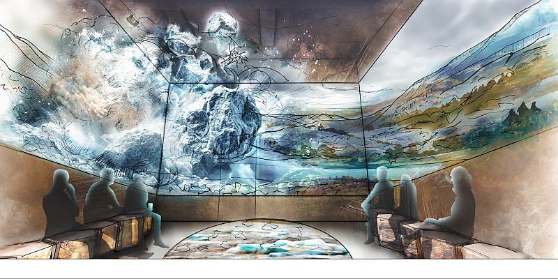
Our Wenatchee Valley Erratics Chapter home for many years at Wenatchee Valley Museum and Cultural Center is now officially closed as of May 18th for a huge renovation project. With that news, now begins the relocation of our chapter’s Education Dept. (i.e., Chapter Headquarters) to the Wells House. We will have our Presentation Area, Internet and Equipment ready in July in time for our August presentation, which is sure to be a reward for our patient Chapter members. The Wells House will provide a historic setting and venue although quaint. The Wenatchee Valley Museum & Cultural Center has long been a place where the history, culture, and creativity of our region come alive. Yet today’s visitors need more than the museum’s current facilities can provide—easier access, more engaging spaces, and opportunities to connect across generations and cultures. The “Branch Out” campaign is Wenatchee Valley Museum & Cultural Center’s answer to that need. By reimagining our campus with connected buildings, welcoming gathering areas, and interactive exhibits, we will create a destination that reflects the energy of our growing community and ensures these stories are preserved, shared, and celebrated for decades to come. Take a virtual fly-through of the new museum design. Relive the joy of the project groundbreaking event. Support the Museum & Cultural Center’s Branch Out building fund campaign. Donations will be matched until June 30th by the Wiedner Group. The Wells House has a long and varied history in Wenatchee. From its construction in 1909, it had been used as family residences, junior college girl’s dorms, administration offices, early classrooms and student activities. It was rescued from demolition and placed on the National Register of Historic Places in 1973, before being deeded to the Museum with the goal of preserving and maintaining it so that it can be used and enjoyed by the public, raise awareness of our valley’s history, and be an architectural asset that contributes to a sense of place and pride within our community.
A Landscape of Transitions

On a cool morning in late March 2026, a group of 16 curious field trip participants stood atop a scenic viewpoint in Richland, Washington looking out over the Pasco Basin, with the Yakima and Columbia Rivers silently flowing below. George Last, a local geologist and field trip leader for the Lake Lewis Chapter of the Ice Age Floods Institute, was explaining a sequence of geologic events that shaped the region surrounding the Tri-Cities. Massive lava flows filled the Columbia Basin with layers of basalt thousands of feet thick. The successive flows combined with tectonic forces uplifted and formed the anticlines along the local section of the Olympic-Wallowa Lineament – on clear display here as a chain of large rolling hills stretching from Rattlesnake Mountain to our northwest to the Horse Heaven Hills southeast of our vantage point. Ancestral rivers, responding to the changes in topography, changed courses across the landscape, cutting new routes towards the Pacific Ocean. Finally, a series of cataclysmic ice age floods roared in from its northerly source, backing up behind the natural constriction of Wallula Gap to form temporary Lake Lewis. The hilltop we occupied would have been completely overtopped by over 400 feet of debris-laden floodwaters. As we looked out onto this geologic foundation, a different landscape emerged in every direction. Our hilltop is capped by a community park. Below us, and along the hillsides of the looming anticlines nearby, the shrub-steppe slopes are blanketed with view-lot homes. Spreading out all around us is a fabric of roadways, housing developments, and commercial and industrial zones. Stretching out to the horizon are the irrigated fields, vineyards and orchards that have been an economic staple of the region since the early days of frontier settlement. Throughout the remainder of our field trip, this juxtaposition of human settlement and natural history is ever-present. A vacant lot, surrounded on three sides by a housing development, hosts an outcrop of the Ringold formation, deposited from the ancestral Columbia River or its tributaries between 3.4 and 8.5 million years ago. An 8.5 million year old basalt flow and Ice Age flood deposits ranging from 780,000 to 220,000 years old lay exposed at various abandoned quarries and borrow pits along our route. Unfortunately, several Ice Age Floods features, previously accessible, are now sequestered behind no trespassing signs or have been lost entirely to new construction. Many participants share stories of excavators uncovering a behemoth of a glacial erratic, to be methodically broken down by hydraulic hammer and hauled away to parts unknown. The final stop on the tour was the Coyote Canyon Mammoth Site outside Kennewick, operated by the MCBONES Research Center Foundation. The site is an active paleontology dig of a Columbian Mammoth, buried in late Pleistocene Ice Age flood deposits and loess. While our guide explains the methodical process of documenting each discovery, tour participants gaze upon a half-buried mammoth bone. One day this fragment will be fully exhumed after resting high in the hills for 17,500 years. It is interesting to think that, like those long buried erratics, this nearly complete skeleton may never have been discovered if not for someone searching with a shovel. It is stories like MCBONES that remind us that amid all of the re-grading, paving, and backfilling, there are stories of discovery and preservation to be shared as well. Conservation and education organizations, in the Tri-Cities and other communities across the Ice Age Floods National Geologic Trail, work tirelessly to preserve natural areas, establish trail networks, and erect educational markers calling attention to the wide variety of plants, animals and geologic features across the landscape. As development continues to expand across this region, the challenge lies in recognizing that the ground beneath our feet is not just a foundation for homes and infrastructure, but a record of deep geologic time and discovery. By fostering a balance between growth and preservation, and by supporting education, research, and access to these remarkable features, we ensure that the stories written in stone–from ancient lava flows to Ice Age floods–remain visible, accessible, and meaningful for generations to come. By John Young, Lake Lewis Chapter of Ice Age Floods Institute
Missoula Floods Feature – A Site of Mammoth Proportions
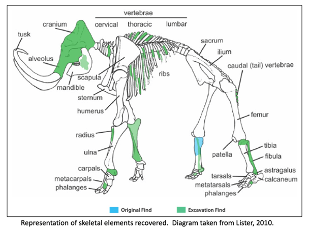
It has been well proven that the Missoula Floods greatly impacted central Washington and there are many examples of the magnitude of the floods, its reach, and dynamics. However, there is still debate on the number, size and timing and dating of these events. What is also less well known are some of the casualties of the floods. At least one feature is helping to tell the story of some of the last floods to grace the landscape. In 2015, a mammoth was discovered at Tonnemaker Hill Farm along the north edge of the Frenchman Hills in Grant County, Washington. Luke Tonnemaker was plowing up an alfalfa field when he made the discovery. Intensive study of the site was led by geologist George Last, paleontologist Bax Barton, local soil scientist and geologist Mark Amara, Gary Kleinknecht, education director, from the MCBONES Research Foundation, a volunteer excavation crew from MCBONES and the Tonnemaker family. The researchers coordinated with farm co-owners, Luke and his father, Kole Tonnemaker, and their wives Amanda and Sonia respectively, to professionally excavate, stabilize retrieved mammoth bones, identify as many bones as possible, and recreate the geology and history of the site. Mammoth remains are not that uncommon in Washington with several hundred animals discovered in the state, though fewer than 100 of those discoveries are located in eastern Washington. What is significant about this mammoth site is that it is one of the few finds that has received this much intensive study. Over 130 bones and bone fragments from a single Columbia mammoth were recovered with about 69 specimens identified. The animal was estimated to be between 25-30 years of age based on characteristics of its dentition, and it even lived with a damaged rib which had healed. George Last prepared diagram The presence of three distinct volcanic ash (tephra) layers and soil analyses suggests that at least four different Missoula flood event episodes are represented in the sediments beneath the mammoth bone bed. Dating of the site revealed that the animal post-dated identified Mount St Helens tephra eruptions that deposited ash in distinct horizons below the bones in water borne deposits. Dates associated with ash samples identified at WSU confirmed two of the layers correspond to Mount St. Helens S series while the topmost tephra shows some compositional variability but had similarities to the J or S series. Tephra ages ranged roughly from 14,000-16.000 years ago. Further dating through Utah State University was provided by optically stimulated luminescence (OSL) samples which gave dates ranging from 16-19,000 years ago. Since the bones are above the highest tephra and OSL sampling sites, the find is definitely younger than 16,000 years ago and was on the edge of one of last Pleistocene Missoula floods slack water lakes to cover this part of Washington. These conclusions were corroborated by analyzing the stratigraphy of the site and describing the soil which confirmed environments of deposition. Since the bones were above the aforementioned tephra layers and OSL sampling locations, and are at the interface of apparent windblown silts and Missoula floods slackwater deposits, it is still unclear how and when the animal died. However, the co-location of the mammoth remains with apparent ice-rafted erratic cobbles and boulders in fine-grained Missoula flood sediments, supports interpretation that the mammoth could have been carried in and left behind by a late breaking Missoula flood. Alternatively, it could have become mired in the mud along the shoreline and/or was killed by predators or even died in a subsequent drier period. Still the intensive studies to date have shown that this is an area with unique geologic history, one that is still unfolding. The Tonnemaker family has the recovered bones on display at their farm store and annually, including 2026, hold tours of the mammoth site during the Othello Sandhill Crane Festival held in March each year. There are a variety of papers, poster presentations and articles published or defended at meetings held by the Northwest Scientific Association and Geological Society of America, and a final report of findings between 2016-2024, with summaries highlighted, is available for viewing at the farm. Article by Mark Amara, Geologist, IAFI Lower Grand Coulee Chapter
2025 IAFI YEAR-IN-REVIEW

We normally include a review of our past year’s activities in our January newsletter for our members and interested others, but that newsletter was just too overfull with other important news. Our 2025 Year-In-Review below was compiled January 30, 2026.This is our 9th year preparing a Year-in-Review report for you, our members. We appreciate your continued support, friendship and membership. INSTITUTE MEMBERSHIP – Our members provide most of our support and much of the reason for the various materials, activities and events we provide. In 1996, we started with 11 members. At the end of 2025, we have 583 members (446 memberships). Our members come from the following states: Washington (67%), Oregon (15%), Idaho (7%), Montana (5%) with smaller amounts from CA, NV, AZ, WY, TX, AK, NM and OK, Canada and Germany. INSTITUTE BOARD ACTIVITIES – IAFI work activities that occur at both the Institute Board of Director level and at the Chapter level generally benefit the entire organization. Listed below are some of these activities. The Board works closely with the National Park Service Program Manager for the Ice Age Floods National Geologic Trail. We have a formal partnership agreement and work cooperatively to further the missions of both organizations. The Education Committee, in partnership with IAFL-NGT and Engaging Every Student, has developed a curriculum program for our 4 state region, “Ice Age Floods Detectives”, of 4 one-hour lesson plans focused on a 4th grade audience. The Education Committee also developed a K-12 Grant program to provide funding to teachers and students for field trips, lab supplies, and to provide funds for other ancillary needs that will enhance implementation of the curriculum. The Cheney-Spokane Chapter established a Student Research Grant program that covers the entire institute area. It recently awarded its first grant The Membership Committee created a Floods Photo of the Week program which provides photos of features throughout the four-state area for all our members. Our webmaster keeps the website (iafi.org) fresh and stimulating. He also, with support from the chapters, issues the Pleistocene Post Newsletter four times a year. Our Membership Manager provides quarterly reports on member/memberships for all chapters and the institute. She responds to membership queries, resolves problems and keeps records current. Our IAFI Treasurer works with our Certified Public Accountant who maintains all our financial records and provides monthly reports to the Board. Our IAFI Store Manager provides service to our members by stocking and processing orders for the most recent books, maps, etc related to the ice age floods. ANNUAL MEMBERSHIP MEETING – This year the annual IAFI membership meeting and field trip was held hosted by the Columbia River Gorge Chapter and there. Approximately 146 people attended the event. Click here for a reflective review of the event. 2025 CHAPTER PROGRAMS – Outreach to inform and educate the public about the Ice Age Floods and their long-lasting impact on our area is a key part of the IAFI mission. Our local chapter programs are possibly the most effective way we meet this challenge. Three of the more important ways we help people learn about the Ice Age Floods are with lectures, field trips and hikes. LECTURES – In 2025 we had 37 lectures attended by over 1549 people. Many more people viewed lectures when they were posted on YouTube. FIELD TRIPS- In 2025 we conducted 22 field trips with 735 attendees. HIKES – In 2025 three chapters sponsored 7 hikes with 106 attendees. PRESENTATIONS TO K-12 STUDENTS Columbia River Gorge chapter – talk and 2 field trips for Hood River New School and a talk for Hood River Elementary 4th grade classes Cheney–Spokane Chapter – Jefferson Elementary School STEM Expo requested that the IAFICS Chapter staff an educational booth on the Ice Age floods. The booth was so popular with the kids and their parents that our chapter was asked to participate in a follow up at the Westview Elementary School STEM Expo. The IAFICS Chapter was contacted by Spokane City Councilman Zack Zappone, requesting a talk and short hike for the North Central Middle School. Lake Lewis Chapter – A number of members helped with education programs at The Coyote Canyon Mammoth Site (MCBONES) near Kennewick. Palouse Falls Chapter: talk and presentation to Pomeroy Home School. Lower Grand Coulee Chapter: Assisted with a presentation at the Ice Age Floods Fest at Dry Falls aimed at educating children on the Ice Age Floods story (350+ attendees). INVOLVEMENT WITH PROFESSIONAL ORGANIZATIONS AND UNIVERSITIES Cheney–Spokane Chapter – Dr. Isaac Larsen (Univ. Massachusetts), accompanied by a graduate student, requested a three-day field trip to collect flood ice-rafted erratics and in-situ exposure for exposure dating of the glacial floods in the Spokane and Vantage areas. Drs. Jim O’Connor and Lydia Staich (USGS) requested a two-day research field trip to look at historical till and flood sites on the Spokane Indian Reservation southeastward to Reardan and Spokane-Mica area. All chapters routinely recruit knowledgeable speakers from universities or state/federal agencies to ensure we are presenting the most current scientific information to our members. PRESENTATIONS AT COMMUNITY EVENTS Cheney-Spokane Chapter – Great Outdoor Sports Expo requested that the IAFICS Chapter staff an educational booth on the Ice Age floods. Don Chadbourne and nine enthusiastic chapter volunteers manned the booth which had heavy traffic on both days. Over 100 people stopped by the booth to get information on our upcoming events and pick up brochures providing information on local flood features and the National Geologic Trail. For the second year the Spokane County Library System asked the Cheney-Spokane chapter to provide speakers for four library branches. All four talks filled the rooms. The Turnbull National Wildlife Refuge asked the chapter to staff a booth and lead a hike. Columbia River Gorge Chapter – Gorge History Museum talk. Nature Conservancy talk at Rowena Crest . Co-led a number of field trips sponsored by the Columbia Gorge Naturalist Program. Coeur Du Deluge Chapter – Again led programs for the Idaho Master Naturalists. Interviewed for Sandpoint Magazine (Summer 2025). Ellensburg Chapter: had information booths at two Ellensburg Farmers Markets. Spoke with about
Doug Huber – Key Puget Lobe Chapter Volunteer
Doug Huber has been an active member of the Puget Lobe Chapter of IAFI almost since its inception in 2007. For the past ten years, Doug has been the unseen hero of our chapter meetings, where he has ensured that the computer, audio, and projection systems were maintained and working as they should at the start of our meetings. In addition, Doug has served as our webmaster, updating the chapter webpage so that our members and members of other chapters alike had access to information on our field trips, meetings, and special events. Hats off to you, Doug, for your tireless efforts to help our chapter stay strong!
Malaga Landslide: Ice Age Catastrophe Along the Columbia River
The east bank of the Columbia River near Malaga, Washington, is home to one of the largest and most visually striking landslides in the Pacific Northwest: the Malaga Slide. Covering an estimated 45 square miles, this massive slope failure poured weakened basalt and sediment into the Columbia River valley at the close of the last Ice Age. Today, it remains easily visible from State Route 28, making it an accessible outdoor classroom for geology enthusiasts and tour participants. The geologic story of the Malaga Slide is a tale of both slow preparation and sudden catastrophe. Layers of basalt from the Columbia River Basalt Group were fractured and weathered over millions of years. Interspersed with weaker sedimentary layers, these formations became prone to failure. Add in groundwater saturation, the erosive power of repeated Ice Age Floods, and over-steepened valley walls, and the stage was set for a massive collapse. Scientists believe the main phase of the Malaga Slide occurred approximately 15,000–13,000 years ago, during the final stages of the Missoula Floods. While the collapse itself was sudden, the landslide likely continued to adjust and move over time, creating the hummocky terrain and displaced boulders still visible today. One of the most intriguing aspects of the Malaga Slide is its interaction with the Columbia River. Some geologists have hypothesized that the massive slide may have temporarily blocked or partially dammed the river. This could have caused short-term ponding upstream, potentially extending back toward Peshastin. Evidence of this interaction remains visible today as enormous boulders and slide debris in the river channel. Travelers heading south from Wenatchee on State Route 28 are treated to a dramatic view of the slide, with scarred slopes and scattered boulders lining the west side of the river. This visibility makes the Malaga Slide an outstanding site for guided geology tours offered by the Wenatchee Valley Erratics Chapter of the Ice Age Floods Institute. Participants learn about Ice Age Flood processes, landslide mechanics, and the long-term evolution of the Columbia River valley. Learn more about Wenatchee-area geology tours: https://wverratics.org or contact@wverratics.org Article by Jeff Becklund, Wenatchee Valley Erratics Chapter President
The Bowl & Pitcher at Riverside State Park
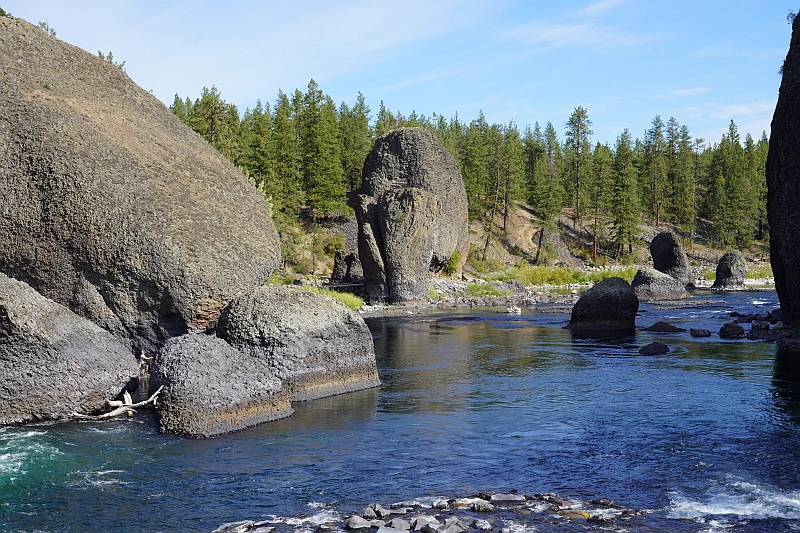
The Bowl and Pitcher is a rock formation along the Spokane River and one of the most scenic sites in the area, with basalt cliffs rising 500 feet above the river and large blocks of basalt in the river causing large rapids. The “Bowl” is a circular depression in the river and the “Pitcher” is a large detached block of highly fractured basalt. The geology of Spokane’s Bowl and Picher features dramatic basalt cliffs carved out of the flows from the Columbia River Basalt Group (CRBG), which reached this area 16 million years ago. There are river and flood deposits of sand and gravel, with granitic boulders forming terraces on the east side of the river, and huge blocks of basalt, causing the Dragon Tooth rapids, downriver from the Bowl and Pitcher. How did those rocks get there? The Spokane and Columbia rivers occupy a long, mostly bedrock canyon near the northeastern boundary of the Columbia Plateau. Glacial Lake Columbia, which formed behind the Okanogan ice lobe, occupied all of the Spokane River and a portion of the Columbia drainage basin during the last Ice Age. Then the glacial Lake Missoula outburst floods first surged over the Columbia Basin beginning around 17,000 years ago, ripping away the CRBG and other bedrock from Bayview, Idaho, to the Pacific Ocean. These floods also deposited a thick sequence of flood gravel in the valley. As Lake Columbia water level dropped, the Spokane River began to remove the sand and gravel fill. Subsequent floods continued to remove the flood deposits, leaving the basalt benches on the west side of the river and the terraces on the east side. Riverside State Park is located northwest of Spokane and consists of over 9000 acres along the Spokane and Little Spokane Rivers. The park is the second largest state park and has many recreational activities including, camping, hiking, mountain biking, horseback riding and boating (Discover Pass required). There are two view points for the Bowl and Pitcher. The first is from a small parking lot off the entrance road from Aubry White Parkway that provides an elevated view of the site. The main parking area is down along the river with a picnic area and a network of trails. From the parking lot you can follow the wheelchair accessible path across the suspension bridge over the Spokane River. From the bridge you can enjoy a view of the features that give the site its name. The original bridge was built in 1942 by the Civilian Conservation Corps. The existing bridge, based on the same plans, opened in 1998. On the west side of the river, you can access a network of trails along the river or climb up along the bluffs above the river.