Missoula Chapter Field Trip TV News Coverage
Missoula chapter field trip – tv news coverage Recently the Montana Natural History Center identified a group of people new to the floods that wanted to do “something” outdoors, but not too early, or too long, or too strenuous, or too late. So IAFI’s Glacial Lake Missoula Chapter worked with the Center to put together a 4 hour, middle of the day field trip. We saved money by using the History Center short bus and our History Center liaison as our driver. Bring your own lunch and water, dress for short hikes and variable weather. The short bus limited us to twelve plus a speaker. We went for $60 per person, $40 for IAFI members, students and Natural History Center members. The trip sold out instantly as soon as we started to publicize. Chapter president Jim Shelden said, “I was surprised that much of the interest was from members that had done 1 or more trips before. The rest was from other newbies. Clearly we want to do more of this.” On trip day a reporter from the local KPAX-TV news popped in and wanted to come along, but he had to follow the bus because we were out of room. A member of The History Center board of directors also wanted to come along, so since we had no seat for him and he wanted to talk more with the reporter, he rode with the reporter. The reporter also needed to be back in town by one PM to edit and get the video ready, so we ran the trip in reverse order to get the summation speech in for our new guests to make the deadline. Then we proceeded to the other sites to show the other participants all the evidence. The day was beautiful with lunch by the river and the reviews were very good. The station got good feedback, the board member was pleased talking to the participants, and we will make the station aware of all our events in the future.
Kititas Valley Historical Museum – Ellensburg
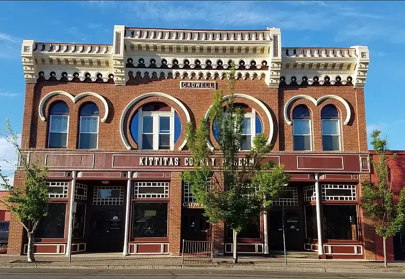
IN THE CITY OF ELLENSBURG… when you want to spend some time indoors, a great place to visit is the KITTITAS VALLEY HISTORICAL MUSEUM. It has about 30,000 items from which more than 50 exhibits and displays are chosen. The mission of the museum is to, “Collect, Preserve and Share the History, Heritage, and Culture of Kittitas County.” In experiencing it you feel a strong connection to the Pacific Northwest. Collection highlights include: Indigenous cultural items (especially from the K’tɨ́taas and Pshwánapam bands). Note the roots here for the local names of Kittitas and Wanapum. Geological specimens, including Ellensburg Blue Agate Some fossilized animals Household goods, textiles, and furnishings Military memorabilia and service records Historic photographs and albums Agricultural tools and equipment Business records and local commerce material Even the building itself is interesting. Built of brick, it was constructed after the Great Ellensburg Fire of July 4, 1889. (There is an exhibit about that fire and its devastation to the town). Some examples of what you will see: So, if you are so inclined, spend some time and enjoy. The museum is open Monday through Saturday from 10am to 4pm. The address is 114 E. 3rd Ave. Ellensburg Admission is free and donations are accepted. Article by Mike Doran: President of the Ellensburg Chapter of the Ice Age Floods Institute
Glacial erratics of the Puget Lowland
Strewn among the forests of the Puget Lowland are an impressive array of Glacial Erratics. Although technically erratics include small pebbles and even sand grains in till, people tend to get the most excited by really big erratics- those the size of a house or building. Whatever their size, glacial erratics often reveal the direction of the ice flow that ripped them from their source region and deposited them at their resting place. Erratics can also help determine the thickness of the ice sheet that deposited them. In the Seattle area, it is relatively straightforward to determine the provenance of erratics containing quartzite, as that rock can not be found anywhere in the Olympics, the Cascades, or in the native bedrock of the Puget Lowland. Quartzite, which is durable and resistant to weathering, is commonly found in river valleys of central British Columbia and in the glacial tills of the Puget Lowland. However, granodiorite erratics found in the lowland and on the slopes of the Olympics and Cascades can be more difficult to decipher. The granodiorite in these erratics is chemically similar to rock bodies both in the British Columbia Coast Mountains and in the Cascades. In the mountains east of Bellingham, erratics found at 5,000 ft of elevation imply that the thickness of the Puget Lobe of the Cordilleran Ice sheet was at least 5,000 ft thick at that location. Maps showing the thickness of the Cordilleran Ice Sheet at various places in Western Washington are drawn, in part, by looking at the depositional altitude of erratics on ridges around the region. The two most massive erratics in the Puget Lowland are composed of Greenschist metamorphic rock. One of the giant erratics of Western Washington hides in the forest in Saratoga Woods Park on Whidbey Island. The Waterman erratic is 38ft high and has a circumference of 135 ft. Analysis of the rock shows that it is composed of Greenschist, a rock containing the low grade metamorphic minerals Chlorite and Epidote. The Greenschist chemically matches the rock of Mt. Erie, a prominent Roche Moutonée found 40 miles to the north on Fidalgo Island. An even larger erratic can be seen in a suburban neighborhood near Everett. The Lake Stevens erratic, 34 ft tall with a circumference of 210 ft, is considered the largest erratic in the Northwest, and possibly the largest erratic in the United States. This erratic is also composed of a Greenschist, although chemical analysis cannot give us a definitive origin for the big rock. There is similar Greenschist on the northern tip of Whidbey Island at Deception Pass, around Mt. Shuksan in the North Cascades, and also up the Fraser River in British Columbia. Article by Dale Lehman
Julie Bishop – Coeur du Deluge Volunteer
Julie Bishop is a founding member of the Coeur du Deluge Chapter of the ice Age Floods Institute and the only continuous member of the Chapter. She has served as Treasurer of our chapter for at least 15 years. Her service to the Coeur Du Deluge Chapter goes way beyond taking care of our financial needs. Julie was and is always there supporting our chapter’s activities (public lectures, field trips and the distribution of IAF-related educational material). She did and does this cheerfully and efficiently. She somehow finds time for our chapter even though she has a full-time job with the Idaho Department of Highways. She has another full-time job at home taking care of the family farm, especially their horses. Julie casually brushes off her contributions to IAFI and Coeur du Deluge, saying that although she did some of the “legwork to start the chapter” the ultimate responsibility for the creation of our chapter was based on the long time flood interest of her friends and co-founders of the CDD Chapter: Kermit Kiebert, Jon Burkhart and Mark Heisel. She continually underplays her contributions. But that is the grace and charm of our Julie Bishop. Thanks for you unstinting service Julie, it’s truly appreciated!
Yvonne Addington – Lower Columbia Volunteer
Lower Columbia Chapter/Ice Age Floods Institute (IAFI) is privileged to recognize our outstanding volunteer, Yvonne Addington, who has always been there for us, doing so much for our Chapter, and that’s been lots! Yvonne Addington looks to the future and connects people to make things happen. Even before the Ice Age Floods Institute was formed Yvonne was an Ice Age fan and was storing the bones of a mastodon dug up in Tualatin, Oregon. Tualatin decided to become an ice age destination and Yvonne was one of the most enthusiastic supporters. In many instances she was the driving force or one of a team of people who made the ice age theme come alive in Tualatin. If you dig into Tualatin’s many ice age interpretive displays, public artwork, artifacts like prehistoric animal bones and erratic rocks, you will find Yvonne’s impact. She arranged many of the donations to the Tualatin Public Library ice age displays including the mastodon which Yvonne stored for many years before it found a suitable home in the Tualatin Public Library. She supported the work of making Tualatin the first partner of the Ice Age Floods National Geologic Trail. She spearheaded the renaming of the Tonquin Trail to the Ice Age Tonquin Trail. The Tualatin River Greenway Trail, with its many ice age displays and interpretive signs, has an “Yvonne Addington Overlook” named in her honor for her extraordinary contributions to the mission of parks and recreation in Tualatin. She arranged the donation and transport of a 20,000 lb. granite boulder and a 5,500 lb. quartzite boulder to the Tualatin Historical Center. She encouraged the donation of a 9’ bronze mastodon statue at the Nyberg Rivers mall. She is a founding member of the Tualatin Ice Age Foundation which is working on the future creation of a Willamette Valley Ice Age Interpretive Center. She is an advocate for the preservation of Ice Age fossils, having kept them from being destroyed by identifying places where they can be adequately displayed, not only at Tualatin Heritage Center, but in larger venues including the proposed Ice Age Floods Interpretive Center and the now completed rebuilding of the West Linn City Hall. In addition to her long established career in public service at so many levels, including judgeship and public administration, she has played a significant role in our Lower Columbia Chapter. When we needed a new home for our featured speaker meetings she was there for us, bringing us into the Tualatin Heritage Center on the third Thursday of each month at 7PM. Today Yvonne is a respected member of the Lower Columbia Chapter Board of Directors.
IAFI Cheney-Spokane College Student Research Grants Available
The Cheney-Spokane Chapter of the Ice Age Floods Institute is offering $500 grants to support geologic fieldwork on Ice Age flood research in the Pacific Northwest. Open to undergraduate and graduate students in the U.S. and Canada, proposals are due by April 15 and must focus on Quaternary flood geology. Applications are reviewed for scientific merit, practicality, and impact. Lab costs for dating techniques are eligible, but funding excludes equipment, salaries, tuition, and travel. Submit your proposal (up to 4 pages) to cheneyspokane@iafi.org Progress report & field photos due the following February. 2025 IAFICS Student Research Grant Guidelines
Krystyna Wolniakowski – Volunteer Extraordinaire for Columbia River Gorge Chapter

It’s not every day you meet someone whose passion for conservation spans from local community efforts to international environmental policy. Krystyna Wolniakowski is one of those remarkable individuals, and the Columbia River Gorge Chapter is incredibly fortunate to have her as a dedicated volunteer. A Local Champion Krystyna is always ready to lend a hand, whether it’s a big project or a small task. She was a vital part of the team, alongside IAFI Membership Manager Lorrie DeKay and IAFI Store Manager Patty Hurd, that brought our “Gorge-ous Gathering” IAFI Membership Meeting to life last May. Beyond specific events, Krystyna is a trusted advisor, offering invaluable insights and feedback on many of the IAFI and Gorge Chapter initiatives. Her dedication to our local efforts is truly inspiring. A Lifetime of Impact Krystyna’s impressive background in environmental conservation and public service is evident in everything she does. As the Executive Director of the Columbia River Gorge Commission, she plays a crucial role in safeguarding the breathtaking scenic, natural, recreational, and cultural resources of the Columbia River Gorge National Scenic Area. Her commitment to environmental stewardship extends far beyond the Gorge. She currently chairs the Klamath River Foundation, leading a successful multi-year project to remove dams on the Klamath River in southern Oregon—a monumental undertaking for river restoration. Krystyna is also a key member of the Romania Foundation, dedicated to developing sustainable tourism in Romania, and she contributes to the One Fly Foundation, which supports river restoration and fisheries health. Global Reach Krystyna’s career highlights showcase over 35 years of dedicated work in nature and landscape protection across the globe. Before her current role, she headed the Western Regional Office of the National Fish & Wildlife Foundation (NFWF) in Portland, overseeing conservation grant programs across seven northwestern U.S. states. From 1991 to 2000, she served as Director for Central and Eastern Europe at the German Marshall Fund of the U.S. There, she developed crucial environmental, economic, and democratic programs in numerous countries after the fall of the Berlin Wall. A standout achievement was her initiation of the Environmental Partnership for Central Europe (EPCE) program in 1990. This pioneering non-governmental grant program provided vital support to pro-ecological civil society organizations in Central Europe, including the Partnership for Environment Foundation in Poland. Krystyna Wolniakowski’s tireless efforts, both locally and internationally, exemplify a profound commitment to protecting our planet’s natural treasures. We are incredibly grateful for her contributions to the Columbia River Gorge Chapter and her enduring legacy in conservation.
Palouse Falls State Park

Palouse Falls State Park, dedicated in 1951, is a 94-acre park showcasing the dramatic Palouse Falls and its unique geological history. The park is a popular destination for viewing the falls, which were formed by Ice Age floods and are a key part of the Ice Age Floods National Geological Trail. The falls were designated as Washington’s state official waterfall in 2014, thanks to the advocacy of schoolchildren from Washtucna. Palouse Falls is one of four of the last remaining year-round waterfalls on the Palouse River that once stood in the path of the ice age floods. It is rich in both geological and human history. The native Palouse Indians called it “Aput Aput” meaning “falling water.” They believed that it was created by the Great Spirit because of his displeasure with the wicked Indians who lived further upstream. This obstacle was a barrier that allowed the salmon to travel no further. Sam Fisher, a Palouse Indian, also tells the story of how four giant brothers and their giant sister used oil from beaver tails to keep their hair shiny. Needing more oil, they searched for the giant beaver and fought with him. All four falls on the river were made when the beaver slapped his tail. At the last battle at Palouse Falls, the beaver struck his tail one last time creating the falls and the bowl it falls into. The vertical cracks in the basalt were made by the claws of the beaver. Palouse Falls has made a powerful impression on all who have visited. For example, one of the fall’s earliest visitors, Laurence L. Dodd in 1867, described the site he saw this way: “just before descending the Snake River hill your eye rests on the grateful green bottom of the Palouse with its clear and pure waters, flowing into the turbid Snake and after ascending the Snake River hill to the northward and eastward, the eye sweeps over a vast extent of country rarely surpassed in rugged desolation and wildness.…” Dodd was accompanied by a few local citizens from Starbuck on horseback to witness the scene he described. Early access to the falls was either by train (many passenger trains would stop here for their passengers to look at the falls) or by coming in from the east side. Robert E. Strahorn, who built the railroad up the Palouse Canyon had the original idea of making Palouse Falls a State Park. But it was not until years later that Washtucna area resident and president of the Washtucna Community Service Club John H. Baumann really pushed the idea. In 1945, Palouse Falls State Park was created. It was dedicated on June 3rd, 1951. The 299 acres that make up the entirety of this vast park were donated by The Baker-Boyer National Bank of Walla Walla, J.M. McGregor of the McGregor Land and Livestock Company of Hooper, and Mrs. Agnes Sells, a resident of Washtucna. Palouse Falls State Park is located off Highway 261, which branches off Highway 260 out of Washtucna. The most popular season for visiting is in the spring when the river is at its highest from winter snow melt. However, each season has its own story to tell as these pictures show. Article by Lloyd Stoess, President IAFI Palouse Falls Chapter
Melanie Bell Gibbs – Valuable Cheney-Spokane Chapter Volunteer
What would you say about a volunteer who has spent literally years advancing the mission of the Ice Age Floods Institute and still continues to do so, even in semi-retirement? You would have to say she is the prime example of the committed, capable, enthusiastic, and gifted volunteer every organization would like to have. When she moved to the Spokane area from Northeast Texas, a proud Texan became a determined and energetic citizen for the state of Washington–and eventually a valuable member of the Ice Age Floods Institute. She became a member of the Ice Age Floods Institute and Cheney-Spokane Chapter as early as 2005. Over the years she was active: Serving as Secretary, Treasurer, President of the Cheney-Spokane Chapter and currently serves as Past President. Recruiting Sponsors and Partners. Writing grants and was successful in funding production of brochures, booklets, flyers and providing for event exhibiting supplies. Partnering with Spokane Parks and Recreation to ensure the accuracy of the Ice Age Floods story in the Ice Age Floods Playground that opened in Riverfront Park in May 2021. Helping Science Coordinators understand the importance of Floods curriculum for Spokane School District. Assisting chapters organize the logistics of hosting conferences. Becoming a Lifetime Honorary Chapter Board Member in 2023. In January 2007, she became involved with the Ice Age Floods Institute’s Board of Directors when she was elected to the Board and became the Secretary. Over the years she: Developed Board Calendars, Board Directories, and Annual Meeting Planning Masters. Served as Treasurer. Implemented new Membership Management system. Continues on the Executive Committee and is Chair of the Revenue Generating Committee. Everyone who knows her agrees she is the quintessential volunteer and we are fortunate to have her.
Volunteer Profile – Sue Billings
How would you like to have on your team a volunteer who embodies the following qualities: Enthusiasm – Support – Upbeat Attitude – Availability to help – Creative Ideas – Encouragement The Ellensburg chapter has such a member in Sue Billings. She has been involved in several meetings and projects over the last years. And she is almost always available to help out when called upon. She and her husband, Tom Ring, live in the town of Selah—reflecting the wide spread area from which our members come. And she is able to do all this in addition to having a rich lifestyle in which they travel and stay involved in other projects. Thanks so much for your involvement and contributions, Sue. We really appreciate it. Mike Doran, President Ellensburg Chapter Ice Age Floods Institute