Volunteer Profile – Sue Billings
How would you like to have on your team a volunteer who embodies the following qualities: Enthusiasm – Support – Upbeat Attitude – Availability to help – Creative Ideas – Encouragement The Ellensburg chapter has such a member in Sue Billings. She has been involved in several meetings and projects over the last years. And she is almost always available to help out when called upon. She and her husband, Tom Ring, live in the town of Selah—reflecting the wide spread area from which our members come. And she is able to do all this in addition to having a rich lifestyle in which they travel and stay involved in other projects. Thanks so much for your involvement and contributions, Sue. We really appreciate it. Mike Doran, President Ellensburg Chapter Ice Age Floods Institute
30 Years of IAFI’s Vision Helped Shape the Ice Age Floods National Geologic Trail
This year marks the 30th anniversary of the Ice Age Floods Institute (IAFI), a milestone that offers an opportunity to reflect on the Institute’s foundational role in bringing the story of the Ice Age floods to national prominence and in establishing the Ice Age Floods National Geologic Trail. Founded in 1995, IAFI emerged from a collective recognition of the need to educate the public about the cataclysmic floods that shaped the landscapes of Montana, Idaho, Washington, and Oregon. Through persistent advocacy, community engagement, and educational initiatives, IAFI laid the groundwork for what would become the nation’s first National Geologic Trail. The culmination of these efforts was the passage of Public Law 111-11 in 2009, which officially designated the Ice Age Floods National Geologic Trail. This achievement was the result of a bipartisan effort, with key support from U.S. Senator Maria Cantwell (D-WA) and U.S. Representative Doc Hastings (R-WA), who were primary sponsors of the trail legislation. Other notable supporters included Senators Ron Wyden (D-OR), Larry Craig (R-ID), Patty Murray (D-WA), and Gordon Smith (R-OR). Their collective commitment underscored the shared value placed on preserving and interpreting this significant geologic history. A celebratory ribbon-cutting event was held on May 27, 2009, just after Congress passed the legislation. U.S. Senator Maria Cantwell and U.S. Representative Doc Hastings were joined by Gary Kleinknecht, then-president of the Ice Age Floods Institute. The ribbon-cutting symbolized more than legislative success—it celebrated years of behind-the-scenes advocacy by IAFI leaders and members who worked tirelessly with elected officials to see the trail officially recognized. Since the trail’s designation, the partnership between IAFI and the National Park Service has been integral to the development and interpretation of the Ice Age Floods National Geologic Trail. Collaborative projects have included the creation of interpretive materials, the planning of educational programs, and the development of enhanced digital maps and content to guide visitors through the trail’s extensive network. These joint efforts have been essential in bringing the story of the Ice Age floods to a broader audience. Looking Ahead: Shared Leadership and Future Potential As the Ice Age Floods National Geologic Trail continues to develop, the professional relationship between the Trail’s current National Park Service program manager. Justin Radford, and IAFI’s president, Dr. Gary Ford, exemplifies a strong and effective partnership. Built on mutual respect and a shared commitment to public education and stewardship, our collaboration helps ensure that strategic goals are aligned, innovative educational resources are developed, and public engagement with the Ice Age Floods story continues to grow. This cooperative leadership reflects the enduring values that brought the Trail into existence and remains essential to its continued success. Plans are underway for expanded educational outreach and increased community engagement initiatives. These endeavors aim to deepen public understanding and appreciation of the Ice Age floods’ impact on the region’s geography, while strengthening the relationships that support the Trail’s future. As we celebrate IAFI’s 30-year milestone, we extend our deepest gratitude to IAFI’s members, volunteers, and supporters. Your dedication has been instrumental in transforming a vision into a tangible trail that educates and inspires countless visitors. Together, we look forward to continuing this journey of discovery and interpretation for years to come By Justin Radford, National Park Service – Ice Age Floods National Geologic Trail Program Manager
Discover A Landscape Carved by Ancient Mega-Floods at Fish Lake Regional Park
Just a short drive east of Cheney, Washington, lies Fish Lake Regional Park, a beautiful 76-acre space offering more than just typical park amenities. This area, easily accessible with parking, play areas, hiking trails, and a swimming beach, tells a dramatic story of a landscape shaped by immense Ice Age floods. You’ll find a paved parking lot at the northeast edge of the park, right by the Fish Lake trailhead. From here, you can hop onto the Columbia Plateau State Park Trail and start your adventure! What makes Fish Lake truly unique is its geology. It’s a double plunge pool, a fascinating feature created by powerful, swirling currents during these ancient mega-floods. These paired, counter-rotating currents scoured out the lake basins, and during periods of low water, you can even spot a partial rock ridge, or rock blade, that divides the two pools. An even larger basalt rock blade separates Fish Lake from the nearby Minnie Creek rock channel and a wide, swampy area it drains into. The significance of Fish Lake isn’t lost on those who study these incredible floods. The local chapter of the Ice Age Floods Institute (IAFI), now the Cheney-Spokane Chapter, has been exploring and educating about this area since 2004. Early field trips introduced members to the flood-formed features around Cheney and the Palouse region, with Fish Lake being a key example. Remarkably, even the pioneers of Ice Age Floods research, Joseph Pardee and J Harlen Bretz, visited the Fish Lake area over a century ago, recognizing the powerful forces at play. For those interested in learning more, a video explaining the formation of these scour lakes is available on the IAFI website under the Cheney-Spokane chapter. Geologically, Fish Lake sits on a fascinating junction. It was carved into a chemically weathered contact zone between very old metamorphic rock, dating back a staggering 1.47 billion years, and much younger basalt flows from the Columbia River Basalt Group, around 16 million years old. The lake’s eastward drainage into the Minnie Rock channel further illustrates the powerful erosive forces of the floods. Evidence even suggests the floodwaters in this area reached incredible heights, exceeding 2600 feet, as seen in a small scour lake near Prosser Hill. So, next time you’re looking for a park with natural beauty and a captivating history, consider visiting Fish Lake Regional Park. It’s a place where you can relax and play while standing in a landscape sculpted by one of Earth’s most dramatic events. Condensed from an article by Dr. Linda McCollum, President, Cheney-Spokane Chapter
Whispers from a Frozen Past: “We Have The Bones” – McBones Mammoth Dig

We know the story…a world gripped by ice. Some twenty thousand years ago, colossal glaciers sculpted the landscape, their icy fingers reaching down through the Idaho panhandle. They choked the ancient Clark Fork River, birthing a vast, temporary lake: Glacial Lake Missoula. Then, the inevitable happened. The icy dam buckled, unleashing unimaginable torrents of water that carved a dramatic path across the land in a series of cataclysmic floods. We see their scars today – stark strand lines etched into hillsides, the labyrinthine coulees, silent dry waterfalls, and the scattered, out-of-place “erratic” rocks, silent witnesses to a watery fury. But beyond the sheer power of these floods, a more profound question lingers: What life thrived in the shadow of this impending devastation? What world existed downstream of Glacial Lake Missoula in the fleeting calm before each deluge? The answer, astonishingly, is life. Vibrant and resilient, creatures roamed the landscape, unaware of the watery apocalypse that would soon reshape their world. And now, buried within the very sediments left by those colossal floods, echoes of this Ice Age existence are being unearthed. Just south of the Tri-Cities in Washington, a remarkable discovery is unfolding. Here, the bones of a 17,500-year-old Columbian mammoth are being meticulously excavated, offering a breathtaking glimpse into a time when ice dominated the north. Imagine this majestic creature, striding across a landscape soon to be ravaged by floodwaters, its final resting place a testament to the sheer scale of these geological events. Now a 17,500-year-old Columbian mammoth is being excavated just south of the Tri-Cities in Washington and visitors can tour the site. For many, a visit to this active dig site is within easy reach – a captivating day trip, a memorable overnight stay, or a fascinating detour along the Ice Age Floods National Geologic Trail. Stand on the very ground where this ancient giant lay buried, a staggering seven hundred feet above the present-day Columbia River, entombed in soil deposited by the very floods that shaped this region. The incredible work of unearthing these secrets is led by the dedicated nonprofit organization, MCBONES. At the Coyote Canyon Mammoth Site, they offer a unique opportunity to step back in time. For a modest $10 per person (sign up at www.mcbones.org), from April until mid-October the public can join guided tours of this active paleontological dig. Witness firsthand the careful process of uncovering these ancient relics and hear the compelling story of this mammoth’s burial, the clues it offers about the pre-flood environment, and the ongoing discoveries that are rewriting our understanding of this dramatic period. Every dollar from tour admissions, gift shop sales, and generous donations directly fuels this vital research, ensuring that these whispers from a frozen past continue to be heard.
Ice Age Floods in Western WA
The Mossback’s Northwest production team met in Thurston County last week to research some geological history. We learned that the Missoula Floods that scoured Eastern Washington weren’t the only massive, earth-shaping floods at the end of the last Ice Age some 15,000 years ago. The retreating Puget Lobe — the last ice sheet’s southern extension, which stopped just south of Olympia — sent massive flows south and west as it melted. But while retreating, the ice also blocked rivers flowing from Mount Rainier, like the Carbon and Puyallup. This created a series of glacial lakes which, when unblocked, periodically let loose with floods and debris flows, shaping the valleys and prairies of the region. We talked at length with geologist Patrick Pringle who has, with his research partner Barry Goldstein, studied this phenomenon. As a result of the floods, Pringle says, there is a lot of volcanic rock — from gravel to massive boulders — in the valleys of South Puget Sound that washed down from Tahoma. More on this is coming in Season 11 this fall. Reprinted from the Cascade PBS ‘The Mossback Den’ newsletter
2025 Columbia Gorge Naturalist Course
The Oregon Naturalist Program at Oregon State University is partnering with the Columbia Gorge Discovery Center and Museum to offer a Columbia Gorge Naturalist field course about the geology, plants, animals, habitats, social and natural history of the Columbia Gorge. An application is required, anyone can apply but priority is given to Columbia Gorge residents. This course is also part of the requirements to become a Certified Oregon Naturalist. Cost: $350.00 (reduced fee options are available) About the Course Learn about the geology, plants, animals, habitats, social and natural history of the Columbia Gorge. Connect with other beginner and expert naturalists in your area. Make an impact! Volunteer for nature-centered programs and organizations in the Gorge. Click HERE to Apply Application opens: February 9 Application deadline: March 9 Application decision: March 16 Course Dates: Introduction Session: April 6 – online over Zoom Session 1: April 13 – Sense of Place (Course Welcome at The Gorge Discovery Center) Session 2: April 27 – Rivers Session 3: May 18 – Oak Woodlands Session 4: June 1 – Grasslands Session 5: July 13 – Western Gorge Forests Session 6: August 17 – Mt. Adams Session 7: Date TBD – Capstone at the Gorge Discovery Center Dates are subject to change.
Order Your Service Recognition Gift
Where (and When) Will Yellowstone Erupt Next?
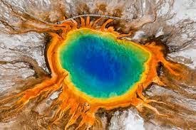
New research indicates it likely won’t blow today, but one region on Yellowstone’s northeastern side is likely to host liquid magma in the long term, possibly fueling future eruptions hundreds of thousands of years from now. Yellowstone’s melted magma lurks in four separate reservoirs within the crust of the caldera. The western reservoirs do not touch the deep mantle rocks that would heat them from below so they will likely start to cool and solidify. But to the northeast, mantle rocks are heating the magma trapped in the crust keeping them liquid and eruptable. Using measurements of earthquake waves and magnetotellurics (measurements of subterranean magma magnetic fields) researchers mapped four main hidden pockets of magma that together contain more liquid magma than was present during large, caldera-forming eruptions at Yellowstone in the past (2.8 MYA, 1.3 MYA and 640,000 years ago). These magma pockets rest as deep as about 6 or 7 miles below the surface, but only in the northeastern region of the caldera is the magma in touch with hot mantle rock that will keep the magma liquid in the long term. Despite the large volume of magma pooling below Yellowstone, the caldera isn’t likely to erupt anytime soon. The magma sits in pore spaces in solid rock, much like water in a sponge. The estimated fraction of magma filled pores is 20% or less, but only when more than 40% of pore spaces are filled can the magma link up, get mobile and start erupting. But that could change over tens of thousands of years as mantle rock warms the northeastern magma pools. Exactly how long that will take, or if it will happen before the mantle rocks in the northeastern region of Yellowstone lose contact with its magma reservoir, remains unknown. Condensed from a Live Science article by Stephanie Pappas
International Old Rock Day – January 7
International “Old Rock Day” Celebrate Old Rock Day on January 7 every year. It’s a day to remember the Earth’s incredible history and to pay tribute to the amazing geologists who help us understand it. We’ve been dependent on rocks since we first walked the Earth, and today it’s no different, with rocks forming the foundation of our daily lives. History of “Old Rock Day” The study of rocks was first introduced by the Ancient Greek Theophrastus in his work, “Peri Lithon” (“On Stones”), and became the cornerstone of geology for other interested scientists. The study was advanced by Pliny the Elder, who recorded numerous minerals and metals in great detail, with a particular focus on their practical use. Although working without the tools we use today, Pliny was able to correctly identify the origin of amber as fossilized tree resin. It wasn’t until 1603 when the word ‘geology’ was used for the first time by Italian naturalist Ulisse Aldrovandi. It took a further 150 years for the first geological maps to be drawn by British geologist William Smith, whose work began the process of ordering rock layers by examining the fossils contained in them. Then, in 1785, James Hutton wrote and presented a paper to the Royal Society of Edinburgh called ‘Theory of the Earth’, which outlined his belief that the world was far older than previously thought. His breakthroughs make him widely considered the first modern geologist. In 1809 William Maclure produced the first geological map of the USA, a task he completed thanks to two painstaking years spent personally traversing the country. With the invention of radiometric dating in the early 20th century, scientists could finally provide an accurate figure for the age of the earth by tracing the radioactive impurities found in rocks. It helped scientists to see that the Earth is one very old rock indeed! Rocks have been essential for human development, which is why we celebrate Old Rock Day and the wonder of the geological world. Why We Love “Old Rock Day” Geology is cool Studying the natural world helps us protect, preserve, and predict it so that we can live in harmony with nature Rocks are useful From the sturdy bricks of our homes to the sidewalk beneath our feet, rocks are essential for human existence Rocks are precious Some of the most coveted things in the world today — gold, diamonds, and other gemstones — are old rocks (minerals) Reprinted from National Today – Old Rock Day
IAFI 2024 BRIEF YEAR-IN-REVIEW

This is a very short summary of our 2024 Year-in-Review report prepared for you, our members, who provide most of our support and much of the reason for the various materials, activities and events we provide. You can read the entire detailed report on our website. In 1996, we started with 11 members. At the end of 2024, we have 587 members in 20 US states, Canada and Germany. While we have over six hundred members, most of the work is done by a small number of people. All of your institute and chapter leaders are volunteers. We are always looking for people willing to work with us to help develop and conduct chapter programs. If you think you might be interested, please contact your chapter president or board members. All help is appreciated, both small and large. Our eleven local chapter’s lectures, field trips and hikes are possibly the most effective way we fulfill our mission to inform and educate the public about the Ice Age Floods and their long-lasting impact. IAFI projects at the Institute board level generally benefit more than one chapter or do work that all chapters might not be able to do by themselves. In 2024 we had 37 in-person lectures attended by over 1425 people with many more viewers on YouTube. In addition, our chapters conducted 22 field trips with 735 attendees and 7 hikes with 106 attendees. IAFI also shares resources and knowledge in collaborations and partnerships with over 30 other professional organizations, universities and state/federal agencies to present up-to-date information to our members and communities. IAFI is a non-profit organization supported by membership dues, donations, profit from field trips and store sales. Our funds are used for new and existing educational and informative materials and programs related to the Floods story, insurance, contract labor and to cover unplanned expenses. We appreciate your continued support, friendship and membership. Prepared January 4, 2025, by Gary Ford, IAFI President