Evidence Elsewhere
Evidence Elsewhere of Ice-Age Floods? Q – Is there evidence elsewhere in the world of ice age floods? Intuitively, I would think glaciers dammed other rivers, created lakes and then eventually collapsed? A – Your instincts are correct. The rivers with big ice and big gorges pretty much all had outburst floods on them. The St. Lawrence Seaway is a flood path as is the Strait between Denmark and Norway and the English channel at the Dover Straits. The Altai Mountain Floods in Mongolia were very steep and fast much like Lake Missoula. The latitude where the ice was melting on its own appears to be more susceptible to very large floods. The Tibetan Plateau also had a series of large floods. Geologist Dr. Vic Baker has created an info-graphic comparing the scale of several terrestrial and Martian flood volumes, though not all are ice-age floods.
Waning Pleistocene Ice Sheet
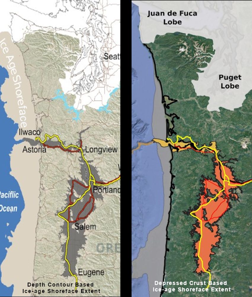
Waning Pleistocene Ice Sheet Affected Megaflood Paths and Local Shorelines Have you ever thought about the how the weight of the ice-age Cordilleran ice sheet might affect the underlying Earth’s crust? There is strong evidence that the crust was depressed hundreds of feet beneath the ice, and since the crust is relatively thin and rigid over a plastic aesthenosphere, that also caused the crust for some distance beyond the ice margins to tilt toward the ice sheet. A new modeling study explored how changes in topography due to the solid Earth’s response to ice sheet loading and unloading might have influenced successive megaflood routes over the Channeled Scablands between 18 and 15.5 thousand years ago. The modeling found that deformation of Earth’s crust may played an important role in directing the erosion of the Channeled Scabland. Results showed that near 18 thousand year old floods could have traversed and eroded parts of two major Channeled Scabland tracts—Telford-Crab Creek and Cheney-Palouse. However, as the ice-age waned and the ice sheet diminished 15.5 thousand years ago, crustal isostatic rebound may have limited megaflood flow into the Cheney–Palouse tract. This tilt dependent difference in flow between tracts was governed by tilting of the landscape, which also affected the filling and overspill of glacial Lake Columbia directly upstream of the tracts. These results highlight one impact of crustal isostatic adjustment on megaflood routes and landscape evolution. Other studies have shown that relative ice-age sea levels were over 300 feet lower worldwide due to the volume of water locked up in ice sheets. Typical depictions of the shoreface extent are generally based on a 300 ft. depth contour, but there is strong evidence that shorelines were up to 200+ ft. higher than present day in marine areas adjacent to ice sheets, again because the crust was depressed by the weight of the ice sheer. A more accurate representation might show a much narrower shoreface in ice-free areas nearer to the ice sheet margin. However, in the Haida Gwaii Strait at the margin of the ice sheet the lower thickness of the ice sheet meant that local shorelines were as much as 550 feet lower than they are today. This was because the much greater thickness of the center of the ice sheet served to push upwards areas at the edge of the continental shelf in a crustal forebulge. It is now widely thought that these emergent ice-free land areas might have provided a viable coastal migration corridor for early peoples making their way to the Americas from Asia during the Pleistocene.
First Peoples
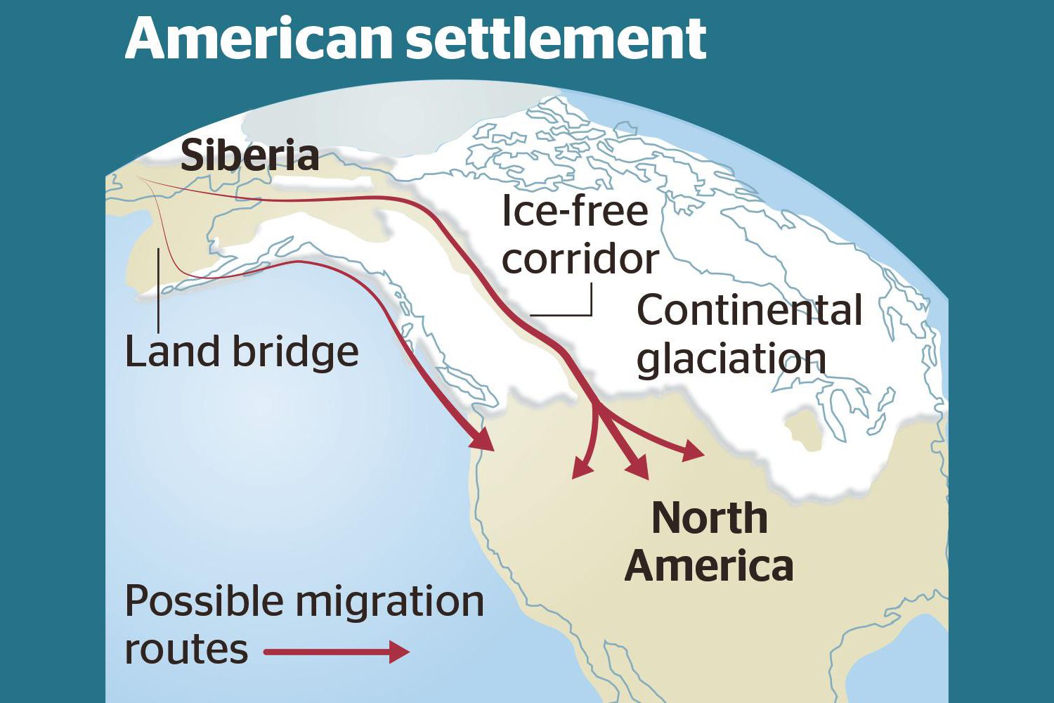
Ice-Free Corridor Human Migration to Americas R e e x a m i n e d Humans In Americas 30,000 years ago??? Analysis of how long erratics have been exposed on ice-free ground in the hypothesized “Late Pleistocene ice-free corridor migration route” suggests that route was not fully open until about 13,800 years ago. The ice sheets “may have been 1,500 to 3,000 feet (455 to 910 m) high in the area where they covered the ice-free corridor,” according to study lead author Jorie Clark, a geologist and archaeologist at Oregon State University. Clark said, “we now have robust evidence that the ice-free corridor was not open and available for the [Late Pleistocene] first peopling of the Americas.” If evidence of humans in the Americas prior to the 30,000 years ago is ultimately found, that evidence does not preclude the possibility of ice-free corridor migration before closure of the corridor.
The Grand Coulee – A Floods Poem
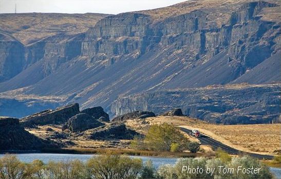
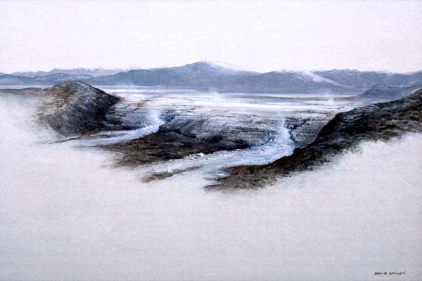
THE GRAND COULEE – A Floods Poem THE GRAND COULEE Older than legends,Younger than mountains,The earth remembersThe Great Inland Sea. And that Sea emptiedIn torrential furyNever imaginedEven in dreams. Down through the canyons,Flood of all riversCarving the couleesTime, time again. Roiled surging waters,Thunder of thunders,Swift toward the oceanReshaping the plain. Gone with the glaciersIs the great Lake Missoula,Gone from remembrance,Like mist in the wind. Yet the story is etchedIn the canyons and couleesLeft for those who imagineTo seek and to find. David Wahl January 4, 2002 Lower Grand Coulee Upper Grand Coulee at Steamboat Rock (left)
Trovants

Geology Can Be Weird – Trovants Trovants Are Stones That Seem to Grow, Move and Reproduce. By: Jennifer Walker-Journey | Jun 21, 2022 | HowStuffWorks/Science/Environmental Science/Earth Science/Geology/Geologic Processes Trovants such as these are found only in Romania and have become such a tourist attraction that they are protected by UNESCO. WIKIMEDIA COMMONS (CC BY SA 3.0)Just when we think we’ve seen it all, Mother Nature throws yet another oddity our way. Welcome to the wondrous world of the geological manifestations known as trovants. These rare bulbous, budging boulders are only found in a small town in Romania called Costesti. So fantastical are these trovants, they’ve found a place in local folklore. Some say they grow, walk and even give birth to baby trovants. Science says they’re probably right. What Are Trovants? Trovants are spherical and slightly irregular-shaped rocks. They can be as small as less than an inch, or a couple of millimeters, in diameter and weigh only a few grams, or they can soar up to 15 feet (4.5 meters) high and weigh several tons. These odd, gravity-defying boulders have baffled observers since the 18th century with many a curious soul suspecting they were dinosaur eggs, plant fossils or even alien pods. Scientists believed trovants to be a type of concretion — a mound of mineral matter (specifically gritstone and conglomerates) embedded within rock layers of limestone, sandstone or shale. They often form from minerals precipitating, or settling, out of water collected around a nucleus of pebble, leaf, shell, bone or fossil. However, in 2008, the International Geological Congress in Oslo claimed trovants were incorrectly classified as concretions because there was no mineral difference between the stones and the sandstone beds on which they sat. There was also no distinct nucleus inside them. Whatever they are, scientists believe that based on their makeup and locale atop the sands, these weird stones are older than man — shaped by earthquakes around 5.3 million years ago, during the Middle Miocene sub-epoch. The surrounding sands also suggest the area was an ancient marine environment, which may explain why bivalve and gastropod fossils can sometimes be found in them. These Rocks Can Grow and Multiply Another oddity about trovants — they secrete cement. This talent makes some people think they may be living creatures and not simply rocks. This cement seepage occurs after a heavy rain shower. When trovants absorb the rain’s minerals, the minerals come in contact with the chemicals already present in the stone, causing a pressure reaction that makes the rocks grow in girth. It’s not something you can see happening. Researchers say the deposition rate for trovants is roughly 1.5 to 2 inches (4 to 5 centimeters) every 1,000 years. This same phenomenon is what causes trovants multiply or “reproduce,” as some might say. When a new growth bauble emerges, likely from water affecting only one side of the rock, and gets big enough, it can break off from the “parent” rock and create baby trovants. Like a Rolling Stone Some people also believe that trovants can “walk,” much like the so-called sailing stones of Death Valley that appear to drift across the flat desert landscape on their own. One researcher allegedly filmed trovants for two weeks and claimed one moved about one-tenth of an inch (2.5 millimeters). While many academics are skeptical about “trovant walking” claims, they don’t deny the possibility that the heating or cooling of the soil could cause movement among the stones. Where Can I See a Trovant? Trovants are almost exclusively found in Romania’s Valcea County at the sand quarry near the Costesti village, along the Gresarea Brook, or in the neighboring Otesani village. To protect these unusual geological specimens, the “Muzeul Trovantilor” or Trovants Museum Natural Reserve, was developed in Valcea County, Romania, in 2004, and is now protected by UNESCO.
Gary Kleinknecht

IAFI Board Vice-President After growing up in the Tri-Cities area I attended Washington State University, BS in Psychology, and the University of South Carolina, MEd in Secondary Social Studies Education. I am retired in the Tri-Cities area after 40 years in high school classrooms. I first heard of the Ice Age Floods around 1980 and began incorporating the topic into my Washington History course. I learned of and joined the IAFI in 1999 and I served as the organization’s president from 2004 until 2010. I was also the founding president of the Lake Lewis Chapter of the IAFI. During the past fifteen or so years I have led numerous floods field trips for the Columbia Reach Interpretive Center in Richland and taught floods classes for the Kennewick School District’s Community Education Program. I am currently serving as Education Director with a citizen science nonprofit group which is excavating a 17,500 year-old Columbian mammoth. The skeleton is buried in Ice Age Floods graded beds near the Tri-Cities.
Jacqui Hair

Jacqui Hair: IAFI Secretary I am a 4th generation wheat farmer in the Walla Walla, WA area. In addition to farming, I drive a school bus! Earning a Bachelor of Arts degree in Anthropology from Whitman College sparked my continued education in geology. My love of geology brought me to an Ice Age Floods event. Eventually I served on the board of the Palouse Chapter, where I am now serving as the vice president.
Gary Ford

IAFI Board President I have been a member of the Ice Age Floods Institute since 2001 and was a founding member of the Cheney-Spokane Chapter. I was president of the Cheney-Spokane Chapter for five years and have been IAFI president since 2013. I have a B.S. and M.S. in Earth Science and a PhD in Soil Science from Montana State University. I mapped over a million acres of glaciated landscapes. I have taught university classes, been an extension educator and lead Forest Service land management teams. I find all this experience useful in leading the IAFI. My main goals as president of the IAFI are to continue to “grow” our membership, be sure we tell the floods story accurately to as many groups and individuals as possible, to work with the National Park Service on the development of the Ice Age Floods National Geologic Trail, and to manage the institute’s human and fiscal resources in the most efficient and transparent manner possible.
Tayler Welch

IAFI Assistant Treasurer I was born and raised in Tri-Cities, Washington. I started college at CBC where I decided to go into accounting, eventually graduating from WSU with my Bachelors in Accounting. I began working for Monte Nail in 2009 and Ice Age Floods was my first client job. I originally handled membership renewals along with financial activity, but now only handle the finance portion.
Nick Zentner

Nick Zentner: Ellensburg Chapter President Nick is a geology professor at Central Washington University in Ellensburg, Washington, but he is better known internationally for his online videos covering the geology of the Pacific Northwest and his Nick on the Rocks series. Starting in the mid-2000s, he began giving public lectures about local geology topics, such as one on the Columbia River Basalt Group. These led to the production of a series of shorts he made called Two Minute Geology. He then produced the Nick on the Rocks series that aired on KCTS-TV in Seattle. During the COVID-19 pandemic Nick created live streaming lectures on various geology topics in a series called Nick From Home, focused on trying to provide an educational environment for children who might be out of school and viewers from around the world. For all of Nick’s outreach efforts, please visit his website: nickzentner.com. Nick hails from Wisconsin, but during a 1983 trip to the Pacific Northwest on break from college he was inspired to study geology, earning his Bachelor of Science from the University of Wisconsin–Madison in 1986 and Master of Science from Idaho State University in 1989. From 1989 to 1992 Nick taught geology at Miami University in Oxford, Ohio, then took on his current position teaching geology at Central Washington University in Ellensburg, Washington. He teaches a popular “GEOL 101 – Geology of Washington” course every Fall and Winter Quarter – and his course is open and free to townspeople! In 2015, Nick received the prestigious James Shea Award, a national award recognizing exceptional delivery of Earth Science content to the general public. Past Shea Award recipients include John McPhee, Jack Horner, Robert Ballard, and Stephen Jay Gould. Nick’s wife, Liz, teaches science at Ellensburg High School, and they have three boys – Max (29), Sam (27), and Jack (25).