WA Geology Releases Stunning Lidar Images
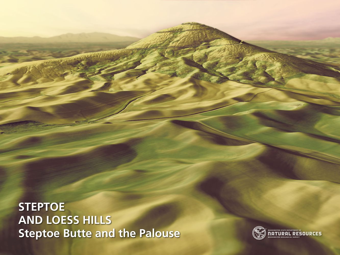
WA Geology Releases Stunning Lidar Images The Washington Geological Survey (WGS) has released 50 high-resolution lidar-derived images of the State’s geology and geomorphology through the Washington State DNR’s Flickr page. The images are available in 16:9 format (7,200 x 4,050 pixels) and 4:3 format (7,200 x 5,400 pixels). Ten of the images are new (see below) and 40 of them were previously available as screen wallpaper (at a lower resolution). Additionally, WGS has released several full-resolution lidar image series that reveal the State’s geology. These images are great for earth science presentations, learning about lidar, and for using as digital wallpaper. They are also large enough to support large-format printing. Click here for the complete Washington State DNR image galleries Mt Adams Lava Flow Outburst Flood Scars West Bar – Giant Ripple Marks Steptoe Butte – Loess Hills Mima Mounds Previous Next
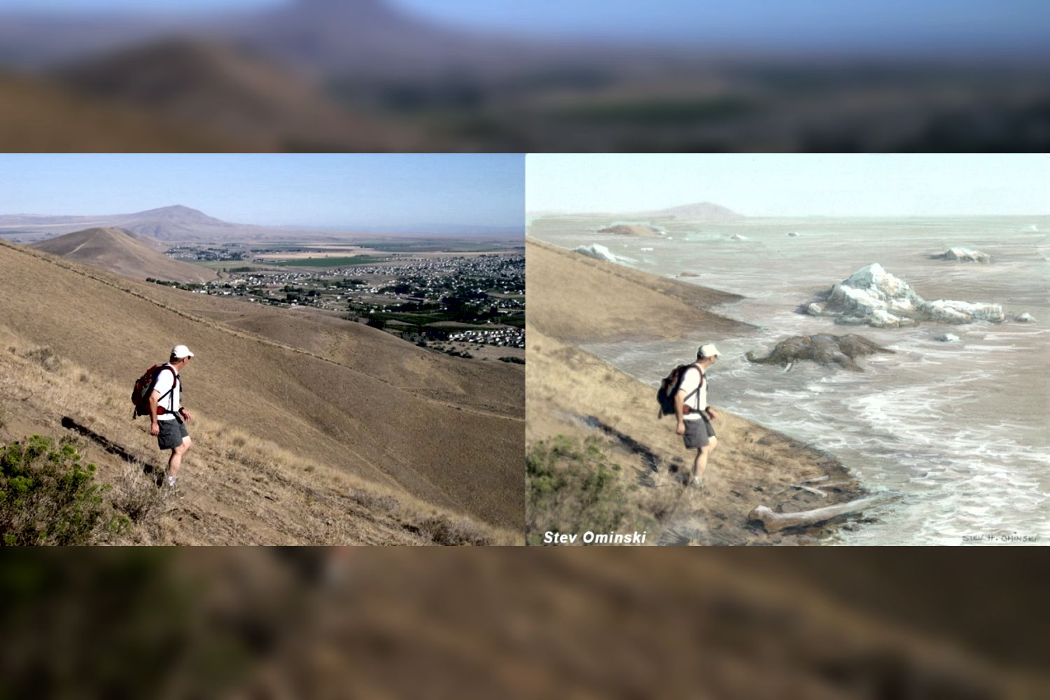
My Hill
my hill As a city kid in the ‘60s my family occasionally visited my grandparents in the farm country of Washington State’s Waterville plateau. My grandfather and two uncles were wheat farmers near the small town of Withrow, the future site of which had been partly hedged in by the Okanagan lobe of the Cordilleran Ice Sheet many thousands of years ago. Sometimes my father and I would join my uncles on the dusty 15-minute drive “out in the hills” to the sagebrush-surrounded corral, well house and large cement watering trough that served the cattle herd pastured there. Overlooking the corral was a tall hill I would sometimes climb while the trough was refilling. Warned to beware of rattlesnakes, a tiring five- or ten-minute ascent would get me to the top. Astride a large boulder, I would survey the corral far below, the sound of the pump engine distantly laboring. Around me was a panorama of other hills, about whose origins it had never occurred to me to wonder. “My hill” was steep enough that even oblong rocks I tossed down its flank would often bounce and roll clear to the bottom. On occasion, this would elicit salty, muffled hollering from Dad to cease and desist. I’m a half-century older, now, but I wish I had then understood the remarkable history of my hill. How would it have felt at that young age to know that a vast ice sheet had blanketed this terrain some 12,000 years earlier and that the hill I stood on had been its progeny? That, as that glacier began to melt, streams and rivulets had formed on its immense surface? That small sinkholes and other weaknesses in the rotting ice had allowed those waters to sculpt caverns inside the glacier? That those waters carried copious quantities of sediment and rock debris captured as the glacier eroded its way hundreds of miles southward? That my hill, like an embryo within an icy womb, had begun to grow inside one of those expanding interior caverns, ultimately to be deposited on solid ground as a kame, a lasting testament to the retreating glacier? Would I have deduced that the glacier had been at least as thick upon the land as my kame was high above the corral below me? That the erratic boulder on which I sat had been deposited on that kame like a cherry atop a geological sundae? I formed an early affection for the Withrow country because of the many relatives who, not so long ago, had peopled that farmland. It’s strange to contemplate that they are mostly gone from this land now, making it seem somewhat alien to me for their absence. And yet that hill remains, a mute sentinel having witnessed the glacier that birthed it, the quiet passage of the millennia, grandpa’s construction of that watering trough in 1948, and the naive delight of a young city kid climbing its flanks in the 1960s. Dan Jordan – IAFI Wenatchee Erratics Chapter
First People in the Americas – When? How?
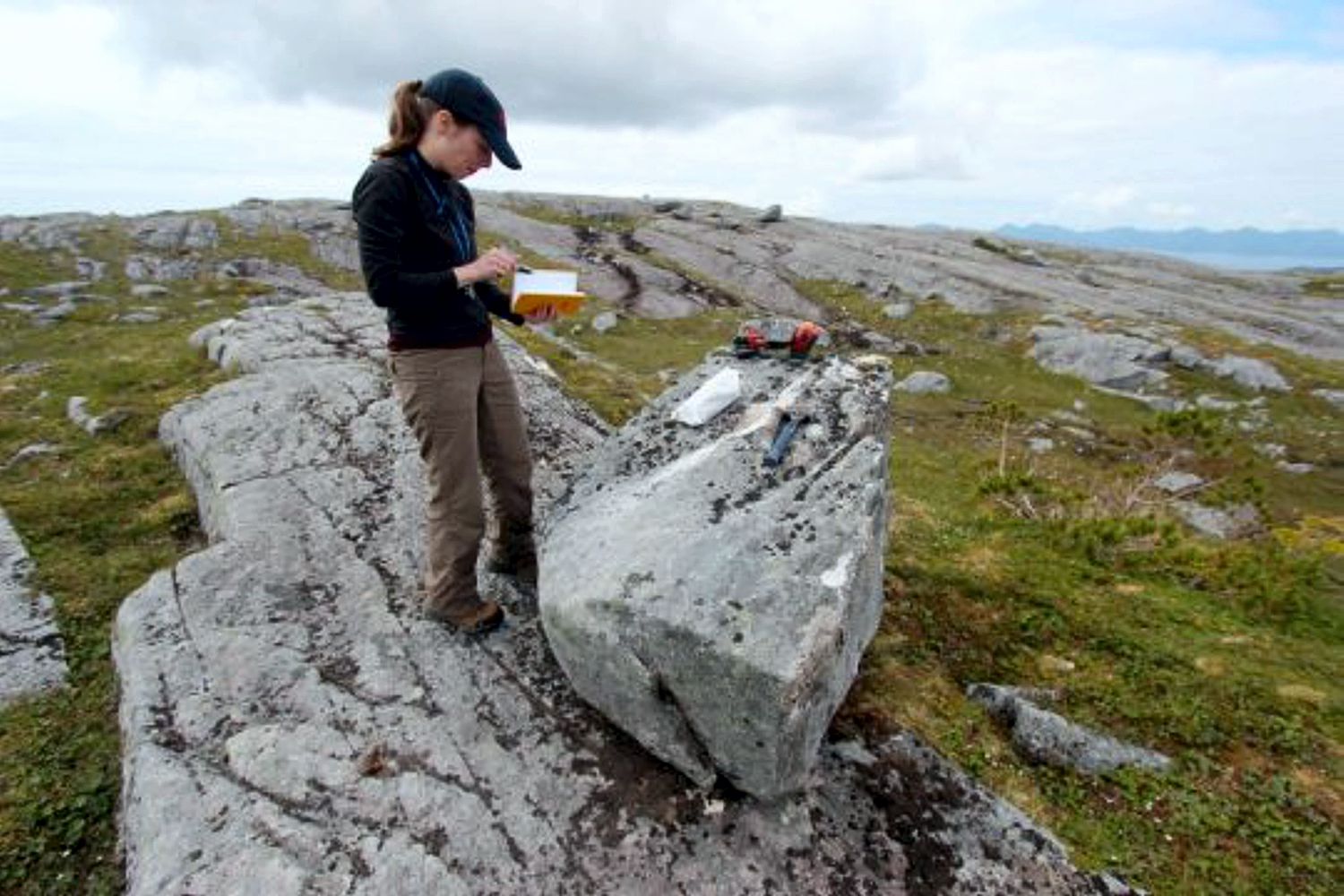
First People in the Americas – When? How? When and how did the first people come to the Americas? The conventional story says that the earliest settlers came via Siberia, crossing the now-defunct Bering land bridge on foot and trekking through Canada when an ice-free corridor opened up between massive ice sheets toward the end of the last ice age. But with recent archaeological evidence casting doubt on this thinking, scientists are seeking new explanations. One dominant, new theory: The first Americans took a coastal route along Alaska’s Pacific border to enter the continent. A new geological study provides compelling evidence to support this hypothesis. By analyzing boulders and bedrock, a research team led by the University at Buffalo shows that part of a coastal migration route became accessible to humans 17,000 years ago. During this period, ancient glaciers receded, exposing islands of southern Alaska’s Alexander Archipelago to air and sun — and, possibly, to human migration. The timing of these events is key: Recent genetic and archaeological estimates suggest that settlers may have begun traveling deeper into the Americas some 16,000 years ago, soon after the coastal gateway opened up. The research will be published online on May 30 in the journal Science Advances. “People are fascinated by these questions of where they come from and how they got there,” says lead scientist Jason Briner, PhD, professor of geology in UB’s College of Arts and Sciences. “Our research contributes to the debate about how humans came to the Americas. It’s potentially adding to what we know about our ancestry and how we colonized our planet.” “Our study provides some of the first geologic evidence that a coastal migration route was available for early humans as they colonized the New World,” says UB geology PhD candidate Alia Lesnek, the study’s first author. “There was a coastal route available, and the appearance of this newly ice-free terrain may have spurred early humans to migrate southward.” The findings do not mean that early settlers definitely traversed Alaska’s southern coast to spread into the Americas: The project examined just one section of the coast, and scientists would need to study multiple locations up and down the coastline to draw firmer conclusions. Still, the work is exciting because it hints that the seafaring theory of migration is viable. The bones of an ancient ringed seal — previously discovered in a nearby cave by other researchers — provide further, tantalizing clues. They hint that the area was capable of supporting human life at the time that early settlers may have been passing through, Briner says. The new study calculates that the seal bones are about 17,000 years old. This indicates that the region was ecologically vibrant soon after the ice retreated, with resources including food becoming available. Co-authors on the research included Briner; Lesnek; Charlotte Lindqvist, PhD, an associate professor of biological sciences at UB and a visiting associate professor at Nanyang Technological University; James Baichtal of Tongass National Forest; and Timothy Heaton, PhD, of the University of South Dakota. A landscape, touched by ice, that tells a story To conduct their study, the scientists journeyed to four islands within the Alexander Archipelago that lie about 200 miles south/southeast of Juneau. The team traveled by helicopter to reach these remote destinations. As soon as the researchers arrived, Briner knew that the islands had once been covered by ice. “The landscape is glacial,” he says. “The rock surfaces are smooth and scratched from when the ice moved over it, and there are erratic boulders everywhere. When you are a geologist, it hits you in the face. You know it immediately: The glacier was here.” To pinpoint when the ice receded from the region, the team collected bits of rock from the surfaces of boulders and bedrock. Later, the scientists ran tests to figure out how long the samples — and thus the islands as a whole — had been free of ice. The researchers used a method called surface exposure dating. As Lesnek explains, “When land is covered by a glacier, the bedrock in the area is hidden under ice. As soon as the ice disappears, however, the bedrock is exposed to cosmic radiation from space, which causes it to accumulate certain chemicals on their surface. The longer the surface has been exposed, the more of these chemicals you get. By testing for these chemicals, we were able to determine when our rock surfaces were exposed, which tells us when the ice retreated. “We use the same dating method for huge boulders called erratics. These are big rocks that are plucked from the Earth and carried to new locations by glaciers, which actually consist of moving ice. When glaciers melt and disappear from a specific region, they leave these erratics behind, and surface exposure dating can tell us when the ice retreated.” For the region that was studied, this happened roughly 17,000 years ago. The case for a coastal migration route In recent years, evidence has mounted against the conventional thinking that humans populated North America by taking an inland route through Canada. To do so, they would have needed to walk through a narrow, ice-free ribbon of terrain that appeared when two major ice sheets started to separate. But recent research suggests that while this path may have opened up more than 14,000 years ago, it did not develop enough biological diversity to support human life until about 13,000 years ago, Briner says. That clashes with archaeological findings that suggest humans were already living in Chile about 15,000 years ago or more and in Florida 14,500 years ago. https://youtu.be/CmxhFgpIacI The coastal migration theory provides an alternative narrative, and the new study may mark a step toward solving the mystery of how humans came to the Americas. “Where we looked at it, the coastal route was not only open — it opened at just the right time,” Lindqvist says. “The timing coincides almost exactly with the time in human history that the migration into
Quaternary

Quaternary—What is that??? Ice Age Floods Institute Members may have heard the term Quaternary during Chapter Presentations and Field Trips, or may have learned that the Quaternary Period represents the last 2.588 million years (~2.6 million years) of earth history, or that it is divided into the Pleistocene and Holocene Epochs. The Quaternary began with the Pleistocene (~2.6 million years ago) and the strata and landscape features reflect the major climate changes of the last Ice Age (synonymous with the Pleistocene Epoch). But where did the term Quaternary come from? The word suggests the number four as in quadrangle, quadrant, quadruplet, etc. For its origins we need to go back a few hundred years to see how the geologic time scale in use today had its origins. The science of geology had a very slow start only beginning to take hold in the late seventeenth and early eighteenth centuries. Both Giovanni Arduino (1714-1795) a mining geologist studying the rock layers in northern Italy around 1759 and Jules Desnoyers working in the Seine Basin in France in 1829 divided their rock sequences into four units; Primary, Secondary, Tertiary and Quaternary. The term Quaternary was applied by Desnoyers to the fourth more recent strata that consists of loose to poorly indurated or cemented strata. The terms Primary and Secondary have been dropped but Tertiary and Quaternary are still used today. These attempts to develop a regional framework of strata were based on the publication of a paper by NIcholaus Steno in 1669 where he laid out the geologic Principle of Superposition. He argued that lower strata in a tectonically undisturbed section must be older than those on top. He also pointed out that strata tend to be deposited in a horizontal position, the law of Original Horizontality. How old these strata might be was not known, new tools would need to be developed to answer that question. However, that is another story. Gene Kiver June 2020
What Made This?
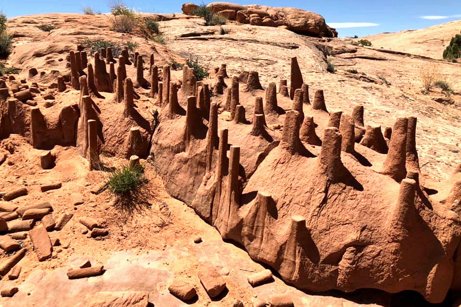
Any idea what made this formation? Q – This is in the Utah desert, south of Green River. I keep hearing that it might be clastic dikes? I have sent this pic to the USGS and they are kinda stumped too but plan to send some paleontologists to check it out. A – The clastic dike explanation looks quite probable. As I understand it, when a fluid (typically water) saturated body of sediment is overlain by another thick layer of sediment the weight of the overlying sediment over-pressures the fluid in the saturated sediment body, resulting in the fluid forcing its way toward the surface, where the pressure is lower, and entraining the accompanying sediment as it rises. Probably looks like a lava lamp, though the processes are distinctly different Comments Any idea what made this formation? — 3 Comments Lloyd DeKay on Dec. 2, 2023 at 2:40 pm said:I suggest the flat tops of these clastic dikes are the result of an impenetrable layer atop the dike-bearing strata, which has subsequently been eroded away.Lloyd DeKay – Webmaster for IAFI Bradai Mohammed on December 2, 2023 at 2:14 pm said: These are called clastic dikes, commonly vertical, they fill open fractures with the help of water, cutting another bed (mud) that’s sitting above, after that it goes through differential erosion, where the soft sediment (mud) gets eroded, and the harder one (sandstone) survive to give you this formation. BRADAI Mohammed El AmineGraphic Designer & Mag. Editor, CEO & Founder of GeoTeach.MePhD student in Stratigraphy-Paleontology, University of Mohamed Ben Ahmed Oran 2, Algeria. Blog: www.geoteachme.blogspot.comInstagram: @the.gneiss.moFacebook: Mohammed BrdYouTube: Explore with Mo Phone: (+213) 798 23 96 50Professional email: Bradai@bk.ru Norman Smyers on July 31, 2020 at 12:18 pm said: My Masters Thesis was clastic dikes of the Panoche Hills (central) California. And yes, the features seen in these photographs from Utah and seen in the recent issue of the Newsletter do look somewhat that they could be associated with clastic dikes. However, I would want to view them up close and personal before saying anything more. For one, the fracture system of the area is a strong clue as to their origins, something difficult to determine with the information at hand. I don’t remember any of my dike structures being evenly truncated at their tops. Obviously at some point in their history there was significant erosion that planed the top of the structure off as well as the surrounding area; and the structures were durable enough to resist subsequent erosion and weathering enough so to persist, as we see them, to present. To make them as durable as they appear to be I would speculate that they were injected from below and into their existing cracks by sediment overlying a fluid rock unit (unconsolidated and wet sediment). Norman Smyers3
Ice In Puget Valley

ice in puget valley Q – My daughter and family live west of Dean Kreger Rd, above Silver Lake, west of Eatonville. I tease her that her yard is gravel held together with a little sand. I believe they are close to the margin of an ice sheet but, I can’t find a map showing the margins. I’ve always been curious when I see different geology features and after watching all of Nick Zentner’s videos I’ve learned enough to be a hazard to myself and society. A – Google Search “Ice in Puget Valley”, “Vashon ice lobe”, “Glacial landforms of Puget Valley” and you will get more than you likely want! WA-DNR – Washington’s Glacial Geology WA-DNR – Glacial Landforms of the Puget Lowland Ice Thickness In Puget Sound
Height of Dry Falls
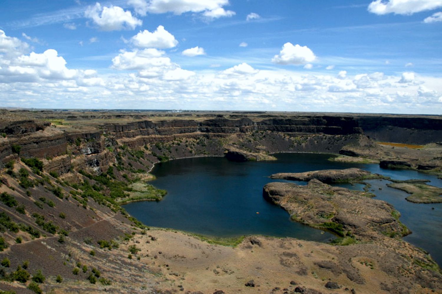
height of dry falls Q – I am a long time resident and have been to Dry Falls several times. Can you please tell me the elevation change between the top of the falls to the lake below ? Do you know or can you direct me to the information? Thank You! A – The height is often cited as 400′ but it appears to be a bit over 500′ based on USGS topographic maps.
Rounded Boulders Spokane
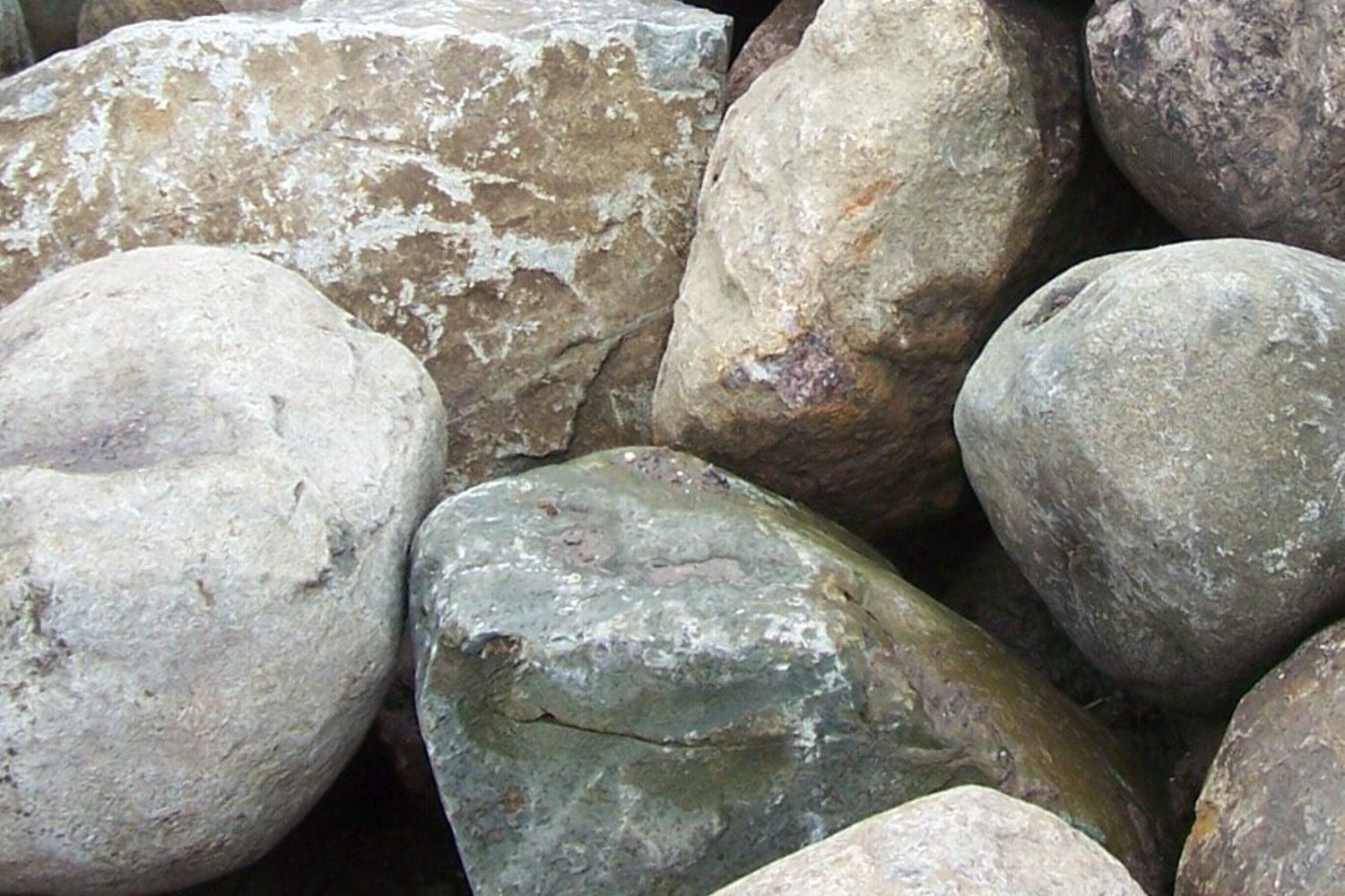
Rounded Boulders in Spokane Ice Rafted Erratics? Q – I have noticed places around Spokane where there are large accumulations of similarly-size boulders. They are smooth and generally about a meter in diameter.. The type of stone varies, but none are Columbia Basin basalt. I assume these are ice-rafted erratics. My question is how did so many end up in a few locations and why are they all similarly sized? My guess is that the flood waters ran into a slope and became still enough to drop similarly-sized loads. Is that right? Or is there another explanation? The South Hill Park and Ride has 81 scattered around the site, some of which I assume were pushed out of the way for paving. Another site nearby has perhaps 40 used for a retaining wall. The Spokane Valley YMCA has a lot, as does the parking lot for the Dishman Hills Natural Area. There are also places along Trent Avenue where these stones are found. Thanks for your reply. – James VanderMeer A – Most all of the well-rounded boulders that clutter parts of the floor of the Spokane Valley are, indeed, derived from the Ice Age floods, but are probably were not ice-rafted to their present locations. They were moved by the tremendous power just downstream from the initial Ice Dam failure, rolled or bounced along the bottom of Glacial Lake Columbia and accumulated rapidly in the deeper parts of the lake. The power of the flood currents dissipated as the waters moved west. Most of the large boulders found father west were probably ice-rafted. The source for these boulders was most likely glacial moraine and stream sediments from Idaho, Montana, and Canada, thus no local basalt in the mix. Because they were “current” derived, they are often sorted in size, and derive from a source where there has been much erosion already and well rounded. More information on this can be had in the online Zoom lecture “What Happened When the Dam Burst” by the IAFI on November 24 by Michael Hamilton.
Spokane Haystack Rocks
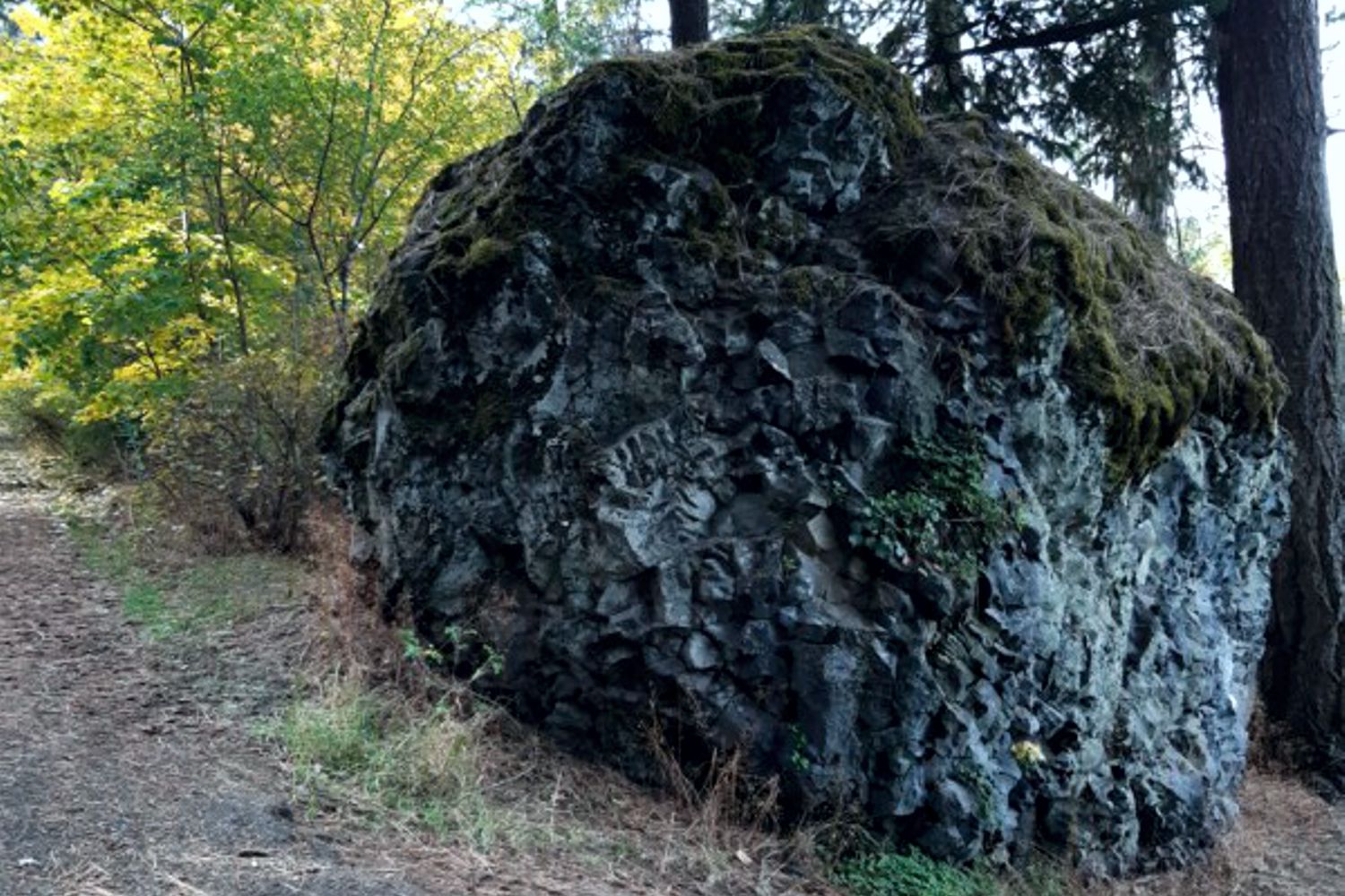
What are Spokane’s Haystack Basalt Mounds? Q – Throughout the Spokane area there are what some call ‘haystacks’, basalt mounds that look like haystacks. There are many such on Spokane’s south hill and I’m including a photo of one that’s in lower Lincoln Park. How did these form? Do they indicate the location of a volcanic vent? – John Ludders A1 – The picture is a large chunk of chill zone basalt. The sequence is chill zone, columnar basalt, entablature, capped by chill zone of the next flow. Like the columns, the chill zone is resistant to plucking but is weak and susceptible to hammering and chipping from rocks in the flow. Many are huge but are basically made in place by chipping, not being carried by flow. – Jim Shelden A2 – The basalt boulder appears to be a portion of the entablature portion of the basalt flow. This portion of the flow commonly worked on by the floodwaters is undercut and portions fall off and get rolled downstream. I have noted hundreds of these boulders in the Spokane area below basalt exposures (cliffs) especially along the north hills (north of Spokane River). They are analogous to the basalt boulders that are observed below Dry Falls (along Umatilla Rock-west side) as seen from the Dry Falls visitor center. The only difference is that the Spokane area gets more precipitation allowing ponderosa pines to grow around them. Also I am not aware that the Cordilleran Ice Sheet advanced south enough into the Spokane vicinity so the basalt boulders are not erratics or “haystack rocks” left after glacial melt. – Brent Cunderla
Badger Mountain Landslide
Badger Mountain Landslide Potential? Q – With all the homes being built on and around Badger mountain in the Tri-Cities, is there any danger of landslides, similar to what is happening at Rattlesnake Hills? I’m unfamiliar with the geology there, and I understand that building homes can affect stability, but are there other likely dangers in that area that potential homebuyers/builders should be wary of? A – There have been prehistoric landslides (now stabilized) on Badger Mountain along with the other ridges nearby. These may have occurred following one more of the Ice Age floods >15k years ago. Renewed landsliding is unlikely as long as there is no significant addition of water that could load the slope and/or lubricate weak zones within, or between, basalt flows – leading to instability. Badger Mountain itself is probably safe since there has been little new development on top or on the steeper sides of the mountain. Most of the mountain is now free from future development, thanks to the Friends of Badge Mountain, who have turned most of the mountain into a preserve. (One exception is the group of new Sterling homes built at the west end of the ridge). Other unprotected ridges may not be as lucky. The cluster of new homes built on top of and along the sides of Little (East) Badger Mountain could generate stability problems, especially if excess water used for landscaping is allowed to percolate underground. There are also a number of new roads dug into the steeper north side of the ridge that potentially could undermine and destabilize the slopes above. Adding irrigation water to these slopes will only increase the likelihood of slope failure in the future. – Bruce Bjornstad