Multnomah Falls and Lodge

Multnomah Falls and Lodge Ice Age Floods National Geologic Trail, Lewis & Clark National Historic Trail Oregon’s tallest waterfall (620 ft.) is just 30 minutes east of Portland and 30 minutes west of Hood River. Offering scenic splendor and a gateway to the Gorge’s Waterfall Corridor, the waterfall is the most visited outdoor attraction in the Pacific Northwest due to its constant flow and proximity to the Historic Columbia River Highway. The falls are fed by rainwater and snow-melt, and its steady stream runs year-round, making it a four-seasons attraction. The highest volume comes in winter and spring, and the waterfall sometimes freezes partially at the height of winter. Located at the base of the waterfall, Multnomah Falls Lodge built in 1925 has excellent views and is home to a restaurant, gift shop, espresso bar and U.S. Forest Service interpretive center. The I-84 parking lot is the only way to access to the falls; parking or stopping is not allowed on the historic highway. It is recommended to visit at off-times, i.e. early morning or mid week. You can also take a guided tour or a shuttle. Visit our Ice Age Floods Institute Field Guides Page for more information on Multnomah Falls and other attractions! Quick Facts Location:Corbett, Oregon MANAGED BY:Multnomah Falls Lodge
Columbia Gorge Discovery Center & Museum

Columbia Gorge Discovery Center & Museum Ice Age Floods National Geologic Trail, Lewis & Clark National Historic Trail, Oregon National Historic Trail The Columbia Gorge Discovery Center & Museum is located on a 54-acre point of land adjacent to the Columbia River and is the interpretive center for the Columbia River Gorge National Scenic Area. This area includes one of the oldest continuously occupied places in North America (over 11,000 years) and parts of the Lewis and Clark and Oregon Trails. On the grounds are walking trails, a pond, scenic overlooks, and historic artifacts. The 48,200 square foot Discovery Center & Museum building contains interactive exhibits about the creation of the gorge; Ice Age animals, including a full-size Columbian mammoth; the Lewis & Clark Corps of Discovery; native peoples of the area; and a life-size exhibit featuring a wagon-raft braving the Columbia River’s current. This is an excellent stop for families with children. Allow several hours for your visit. Modest admission is charged. SITE INFORMATION:Safety Considerations More Site Information Oregon National Historic Trail Quick Facts Location:5000 Discovery Drive, The Dalles, Oregon Significance:Interpretive center for the Columbia River Gorge National Scenic Area MANAGED BY:Columbia Gorge Discovery Center Museum Inside the Columbia Gorge Discovery Center and Museum
Hat Rock State Park
Hat Rock State Park Ice Age Floods National Geologic Trail, Lewis & Clark National Historic Trail Hat Rock is an erosion remnant warn way by floods from glaciers which melted over ten thousand years ago. Lewis and Clark saw this monument on their expedition and noted that it had a strong resemblance to a man’s hat. Imagine seeing this otherworldly boulder in the middle of a field of rolling hills in a vast, unexplored territory. The members of the expedition must have felt like they were on a different planet! While visiting Hat Rock today doesn’t have the same element of surprise, visitors will be able to enjoy a truly unique and beautiful landscape. The main attraction is of course, Hat Rock, and most people hike in the park to admire its natural beauty. Outside of Hat Rock, there are fields of scrub-land peppered with flowers as well as lush trees surrounding bodies of water. The park has its own pond, which is popular for fishing as it is teeming with rainbow trout. It also has access to a lake, a great place for water sports, and a sand volleyball court near the weather shelters. It is a perfect place for the whole family to experience the beauty of Oregon along the Columbia River. Quick Facts Location:Hermiston, OR MANAGED BY:Oregon State Park
Grand Coulee National Natural Landmark
Place Grand Coulee National Natural Landmark Ice Age Floods National Geologic Trail This large geological feature is approximately 50 miles long and averages about 1 mile in width. Within the Coulee there are illustrations of a series of geological events beginning with a low range of granite mountains through which the ancestral Columbia River flowed. Outpourings of lava built up the Columbia Plateau, diverting the course of the river. There followed deformation of the lava beds, advance and recession of glacial ice, the cutting of a new river course, the formation and retreat of waterfalls, and the return of the Columbia River to its present channel, leaving the Coulee high and dry until man turned part of it into a huge reservoir by artificial damming. Much of the evidence from which this geological story is reconstructed may be seen from Dry Falls State Park; the park is located about 5 miles southwest of Coulee City. Quick Facts Designation:National Natural Landmark
Sun Lakes-Dry Falls State Park

Place Sun Lakes-Dry Falls State Park Ice Age Floods National Geologic Trail As you enter Sun Lakes-Dry Falls, you may feel like you’re on another planet. The park is surrounded by one of Washington’s most striking and historically significant landscapes. Dry Falls is a geological wonder of North America. Carved by the Ice Age Floods more than 13,000 years ago, the former waterfall was once four times the size of Niagara Falls. Today, the 400 foot-high, 3.5 mile-wide cliff overlooks a big sky and a landscape of deep gorges and dark, reflective lakes. The park is a notable site along the National Ice Age Floods Geologic Trail. Visitors – especially history and geology geeks – will appreciate the Dry Falls Visitor Center, where interpretive displays tell the story of the floods and their effects on Washington’s landscape. Call (509) 632-5214 for seasonal hours and to arrange a tour. The park also offers great recreation. Nothing beats the boat launch and social atmosphere of Park Lake. A shimmering Deep Lake presents a remote paddling and kayaking experience. The lure of Dry Falls Lake entices anglers to cast out for trout. Hiking Trails wind through the scented, sage-dotted hills to table-top cliffs with panoramic views. The park even offers nine-hole and miniature golf for visitors who equate a desert vacation with a good game on the green. The Dry Falls Visitors Center is open for summer operations Monday and Thursday for guided tours. DRY FALLS VISITOR CENTER HOURSMay 1 – Oct. 31 10:30 a.m. – 12:15 p.m. and 1 p.m. – 3:30 p.m., Friday – Sunday 10:30 a.m. – 12:15 p.m. Monday and Thursday group tours by reservation only 1 – 3:30 p.m. Monday and Thursday open for general admission Closed Tuesday and Wednesday CLICK HERE TO BOOK YOUR TOUR RESERVATION NOW! Quick Facts Location:35661 HWY 17 North Coulee City, WA 99115 Designation:National Natural Landmark MANAGED BY:Washington State Parks
Steamboat Rock State Park

Place Steamboat Rock State Park Ice Age Floods National Geologic Trail Rising 800 feet and spanning 600 acres, Steamboat Rock will impress the most seasoned of travelers. Carved by Ice Age Floods into a dramatic, lake-dotted canyon, Steamboat Rock State Park’s landscape dates back at least 13,000 years. Known as “scabland,” the area appears barren, but it is teeming with shy (and not-so-shy) wildlife, spring flowers and sagebrush. The hike up the columnar basalt butte (a 650-foot vertical gain) is a must for anyone who is able. Atop Steamboat Rock, the trail meanders over flat ground to viewpoints of the Grand Coulee and the craggy peaks of the Okanogan-Wenatchee National Forest. Below the rock, the lake reflects big desert skies. Do you prefer water to trail? The park features 320 feet of dock and seven watercraft launches on Banks Lake. Anglers, swimmers, paddlers and water sports fans will find respite on a hot summer day. Mountain bikers and equestrians can take off on the trails of Northrup Canyon, and the Grand Coulee Dam makes an interesting side trip. After a day of discovery, your tent, RV or cabin site will be a welcoming place to watch the evening glow. By the end of your stay, you will not only be impressed, but will likely be so sun-warmed and rested, you won’t want to leave. PARK FEATURES Steamboat Rock State Park is a 5,043-acre camping park with 50,000 feet of freshwater shoreline at the north end of Banks Lake and a columnar, basaltic rock with a surface area of 600 acres. Three campground areas and a large day-use area are protected from winds by tall poplars. Discover Pass: A Discover Pass is required for vehicle access to state parks for day use. For more information about the Discover Pass and exemptions, please visit the Discover Pass web page. Automated pay stations: This park is equipped with automated pay stations for visitors to purchase a one-day or annual Discover Pass and boat launch permit. Quick Facts Location:51052 Highway 155 Electric City, WA 99123
Spokane’s Riverfront Park – Ice Age Floods Playground

Place Spokane’s Riverfront Park – Ice Age Floods Playground Ice Age Floods National Geologic Trail Learn about the events that shaped our region’s geography while you play! Enjoy a 3-story slide tower, splash pad and water fall, a log jam climber, and dig for mammoth bones. Also available are basketball courts and a skateboard park. Playground Hours 6am – Dusk Learn about the events that shaped our region’s geography while you play! Enjoy a 3-story Columbian Slide Tower, Glacial Dam Splash Pad, a Log Jam Climber, an Alluvial Deposit Fossil Dig and MORE! The playground covers 40,000 square feet at Riverfront North Bank. Splash Pad Hours 11am – 7pm Special Events Host a birthday, graduation party or other special event at the North Bank shelter located at the Ice Age Floods Playground in Riverfront Park. Fill out this event inquiry form to reserve your date! Quick Facts Location:832 N Howard St, Spokane, WA 99201
Bowl and Pitcher (Riverside State Park)

Place Bowl and Pitcher (Riverside State Park) Ice Age Floods National Geologic Trail What forces carved the Bowl and Pitcher and why did these rocks end up in the river? To answer these questions we must know what types of rock make up this area. The dark rocks here are Columbia River Basalt (CRB) lava flows. These rocks are part of the Grande Ronde Basalt, one of the most voluminous of the CRB eruptions. Sandwiched between the layers of lava is the Latah Formation, a sedimentary unit made of clay, silt, and sand. Unlike the sedimentary formations of western Washington, which are almost all marine in origin, the Latah rocks were deposited in a huge lake. This lake formed when the CRB lava flows descended on eastern Washington and blocked off rivers that already flowed through the area. Large amounts of sediment were deposited into this lake. When new lava flows arrived, they cooled quickly on contact with the water. We see this in the steep cliffs at the Bowl and Pitcher area, on the western side of the Spokane River. The cliffs expose rounded pillow lavas surrounded by palagonite, which is altered volcanic glass. Both pillow lavas and palagonite are types of rock that form when hot lava is exposed to cold water. When the ice age floods surged over the Columbia Basin, they eroded away the rocks in the Bowl and Pitcher area. The Latah Formation was much easier to erode than the Grande Ronde lavas, so it was broken down and removed first. With their support gone, the basalt rocks on top of the Latah layer became unstable and tumbled down into the river channel. The basalt rocks tend to weather into rounded, bulbous masses like those seen at the Bowl and Pitcher. These shapes result from the curved joints that form in the lava as it cools. Quick Facts Location:9711 W. Charles Road Nine Mile Falls, WA 99026 Significance:Riverside State Park occupies 9,194 acres along the Spokane and Little Spokane rivers just north of Spokane. With nearly 200,000 feet of shoreline, Riverside is home to Ponderosa pines, lakes, marshes and a wide variety of wildlife. MANAGED BY:Washington State Parks
Grant’s Getaways – Oregon’s Erratic Rocks
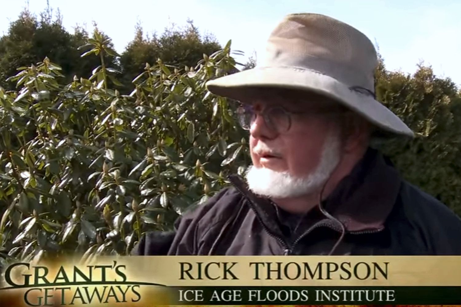
This episode of Grant’s Getaways features Lower Columbia President Rick Thompson and the Floods-borne erratics of the Willamette Valley.
Frenchman Coulee Drone Video
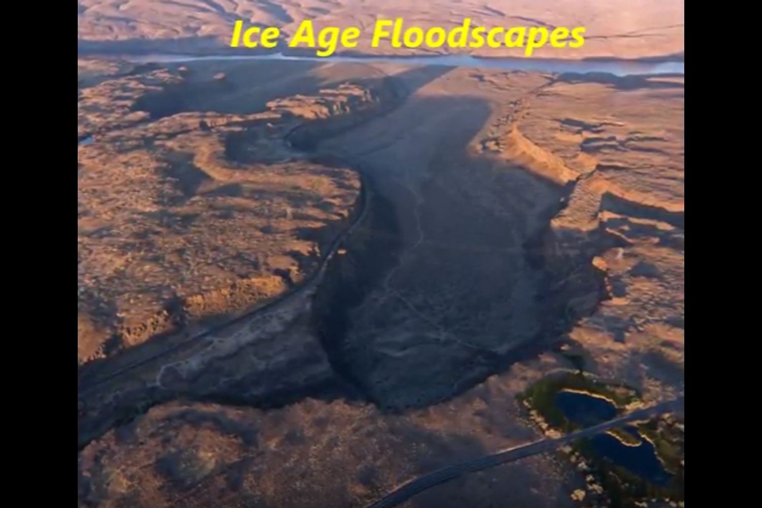
Bruce Bjornstad is at it again with his awesome Ice Age Floodscapes drone videos, this one from Frenchman Coulee. Watch it below and visit his Ice Age Floodscapes YouTube channel.for many more.