
Palouse Falls
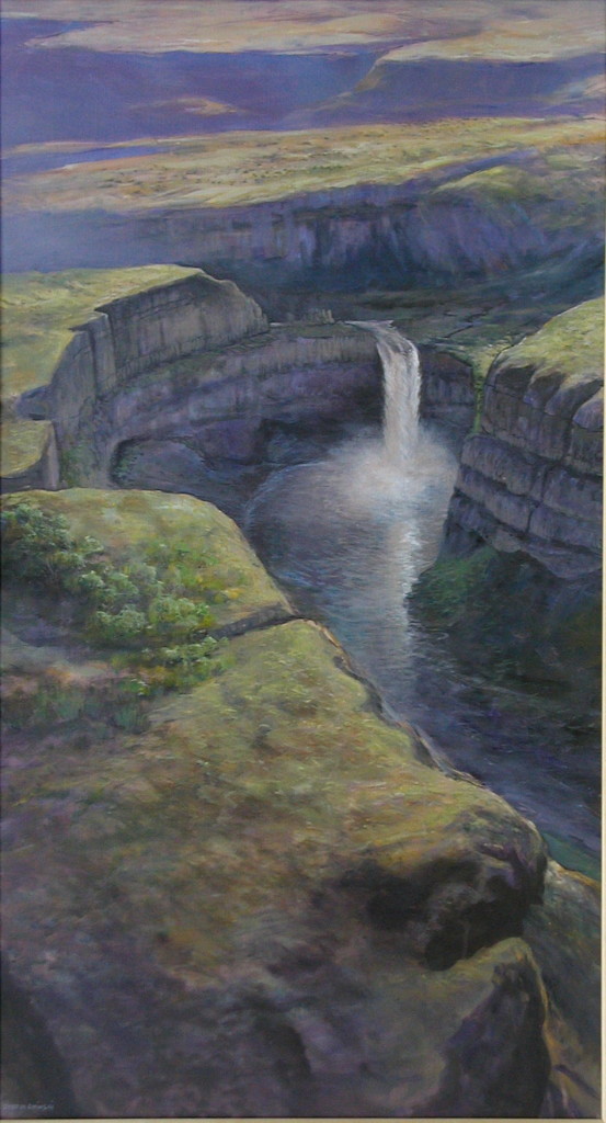
![]() Palouse Falls State Park – Flood-Streamlined Hills, Marmes Rockshelter
Palouse Falls State Park – Flood-Streamlined Hills, Marmes Rockshelter
Best Observation Points By Automobile
- Palouse Falls is best seen from the overlook at Palouse Falls State Park, 2.3 miles east off State Route (SR) 261, approximately 60 highway miles from Pasco, Washington.
- Flood-Streamlined and Scarped Palouse Hills are best seen along SR 261 between Washtucna Coulee and Palouse Falls, 7 miles east of intersection with SR 260 and 1.5 miles west of turnoff to Palouse Falls.
- Another set of streamlined Palouse Hills lies along Staircase Rapids. Take SR 261 2.9 miles north of Washtucna to Haase Road. Starting at 1.5 miles along Haase Road are several excellent examples of scarped and streamlined Palouse hills all the way to the top of the ancient rapids.
Palouse Falls Trails: Wander along the brink of 300-foot-high, precipitous cliffs that zigzag along the Palouse River Canyon. View spectacular Palouse Falls that drops 185 feet over a cataract cliff left behind by powerful Ice Age floods. Other, more challenging trails lead deep into the canyon both above and below the falls.
Trail Head Location: N 46.664033°; W 118.227443°, parking lot of Palouse Falls State Park (Figure 1).
Warnings: Beware of dropoffs, steep talus slopes, rattlesnakes, flash flooding and poison oak. Note that a Washington State Discover Pass is required for parking in state parks. However, the necessary parking permits are available for purchase on site.
Trail Length / Difficulty: 0.8 to 1.4 miles round trip / Easy to difficult
Trail Descriptions:
Rim Trails: Excellent views of the Palouse Falls and the Palouse River canyon can be found by hiking along the canyon rim in either direction from the parking lot of Palouse Falls State Park. Casual walkers should limit their hike to the trails that rim the canyon. Those with good hiking boots, balance, and a sense of adventure may wish to explore further and descend to the bottom of the canyon.
North Trail: The trail to the north follows the rim for approximately 0.4 miles before dropping down to railroad tracks. The trail descends farther across a scree (talus) slope, for another 0.1 mile into the canyon to the Palouse River. At the river, the trail turns south, hugging the west side of the canyon for 0.2 mile, where it ends at the basalt pinnacles near the top of the falls. Hikers are rewarded with a spectacular view down the canyon as well as the basalt pinnacles and the rush of Palouse Falls immediately below.
South Trail: Another trail leads south of the Palouse Falls parking lot to follow the rim for 0.1 mile to the covered Fryxell Overlook. From here, the trail continues along the rim a short distance before dropping down to railroad tracks at 0.2 miles from the parking lot. From this point it is a steep and rocky descent to the valley bottom at 0.4 miles from the parking lot. Once at the river, retrace your steps to the parking lot, or for more adventure, continue to explore up or down the river. No well-established trails exist beyond this point, and hiking gets difficult downriver. Your best bet is to explore closer to Palouse Falls.
Marmes Overlook Trail: Climb to a spectacular overview of the lower Palouse River canyon and Marmes Rockshelter, one of the earliest know human-habitation sites in the Mid-Columbia Basin. Gaze across the Snake River to giant, 200-foot-tall Mid-Canyon flood bar.
Trail Head Location: N 46.598°; W 118.2184°, at the north end of Lyons Ferry Park, located along SR 261, approximately 65 miles northeast of Pasco, Washington (Figure 1).
Warnings: Beware of poison oak, rattlesnakes, and steep slopes, especially along the edge of the riverbecause the banks can slide and fall away unexpectedly.
Trail Length / Difficulty: 1.4 miles round trip / Easy
Trail Description: Heading north you can look back across the Snake River for a spectacular view of massive and broad Mid-Canyon Bar. Continue hiking northeast to the nearby hilltop at 0.7 miles to view the flooded Marmes Rockshelter site. This site was originally recorded in 1962 during an archeological survey led by Richard Dougherty of Washington State University. A series of 11 partial-to-complete human skeletons, were found within or below the rockshelter, along with 700 to 800 artifacts, cultural features, and animal bones. Animal bones, tied to human activity at the shelter, date back to ~13,000 calendar years ago, making Marmes one of the oldest, inhabited sites, discovered in North America.
 Material taken in large part from On the Trail of the Ice Age Floods: A geological field guide to the Mid-Columbia, by Bruce Bjornstad, 2006, Keokee Books, Sandpoint, Idaho.