
Drumheller Channels
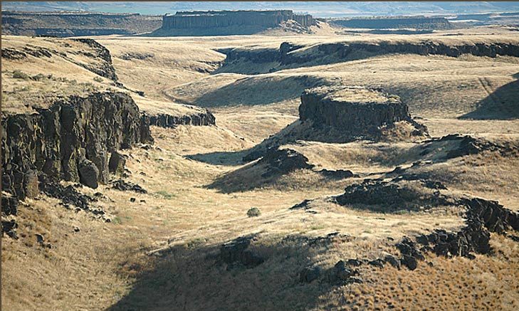
![]() Drumheller Channels National Natural Landmark, Butte-and-Basin Scabland
Drumheller Channels National Natural Landmark, Butte-and-Basin Scabland
Best Observation Points By Automobile
- From Othello, drive 9.1 miles northwest on McManamon Road, a roadside pullout will be on your right, located at N 46.904049°; W 119.307105°. A short (<100 yard) trail leads to the National Natural Landmark viewpoint.
- From Othello, drive 5.7 miles northwest on McManamon Road before turning right (north) onto unpaved Morgan Lake Road; continue north up the middle of Drumheller Channels approximately 8 miles all the way to O’Sullivan Dam.
Frog Lake Trail: Follow a well-marked trail (with interpretive signs) along Crab Creek before ascending and looping around a tall, flood-swept mesa for some spectacular vistas of wild scabland terrain.
Between floods from Glacial Lake Missoula, a lobe of ice (Okanogan lobe) continued to block the Columbia River near Grand Coulee Dam. So, between floods, drainage from the Columbia River and Glacial Lake Columbia was all forced to go down Grand Coulee through Moses Lake, Drumheller Channels, and Lower Crab Creek Coulee before it emptied into the present Columbia Valley just north of Sentinel Gap. During this time, the former Columbia River, now located more that 30 miles to the west, flowed here in place of tiny Crab Creek. It wasn’t until after the Okanogan lobe melted back to a position north of Grand Coulee, at the end of the last Ice Age, that the Columbia River re-established itself into its present path.
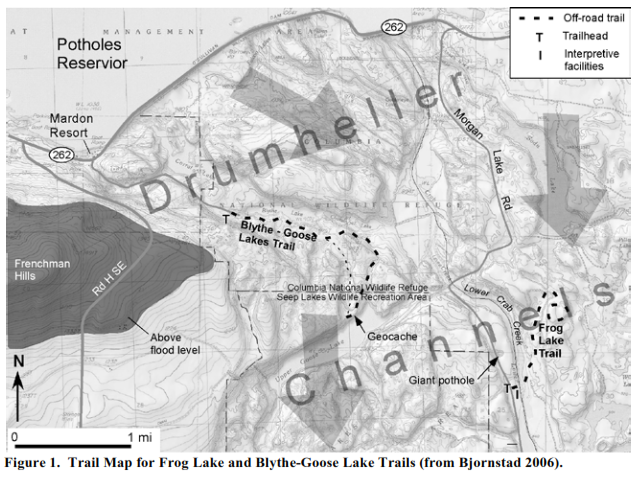
Trail Head Location: N 46.936742°; W 119.244680°, on the west (left) side of Morgan Lake Road (Figure 1). Note that a Washington Department of Fish & Wildlife Discover Pass or Vehicle Access Pass (issued free with purchase of a hunting or fishing license) is required to park here.
Warnings: No shade or potable water is available. Keep a safe distance from steep rimrock along edges of coulees, mesas and rock benches.
Trail Length / Difficulty: 2.7 miles / Easy to moderate
Trail Description: Cross Morgan Lake Road and follow signs to Frog Lake Trail. The trail enters a side coulee that splits off the main Lower Crab Creek coulee, passes Frog Lake (dry in summer), to an abandoned spillway at the head of the side coulee with views of scabland to the north. The trail bends to climb to the top of a flat-topped mesa of flood-swept basalt and follows the rimrock around the edge of the tall mesa for 0.5 miles. Here views of wild and wonderful examples of butte-and-basin topography give the hiker a feel for the tremendous erosive power behind the Ice Age floods. The trail loops around the mesa then retraces its path back to the trailhead.
Blythe-Goose Lakes Trail: A well-defined trail links two large, seep-filled rock basins, Blythe Lake and Upper Goose Lake, through a wild plexus of coulees and channels. An option on the return is to travel cross country via a shortcut through a higher, mostly dry rock basin cratered with huge, deep potholes.
Trail Head Location: N 46.958412°; W 119.294543°, near the boat-launch area for Blythe Lake (Figure 1). Note that a Washington Department of Fish & Wildlife Discover Pass or Vehicle Access Pass (issued free with purchase of a hunting or fishing license) is required to park within Drumheller Channels.
From Othello, head northwest on McManamon Road. At 11 miles turn right (north) onto Road H SE. After 4.5 miles Road H SE terminates at SR 262. Turn right (east) and continue 0.5 miles to Mardon Resort. At milepost 14 (MP 14) turn right on to gravel road at “Public Fishing” sign, follow road 1.5 miles to the boat-launch area for Blythe Lake
Warnings: No shade or potable water is available. Steep drop-offs into cataracts, potholes, and coulees. Keep a safe distance from steep edges.
Trail Length / Difficulty: 2.7 miles / Easy to moderate
Trail Description: The trail begins at the gated road and continues along the south side of Blythe Lake. Soon after passing a small, shallow pond on the right, the double-track road turns into a well-defined single-track trail that ascends the slope on the right. The trail climbs approximately 60 feet before leveling off onto a rocky bench and heading east, then southeast, past several deep, round to elongated potholes and rock basins on the right (south). The single-track trail ends at a “T” with a double-track jeep trail. Near here, you can see an especially round pothole, with unusual point of more-resistant basalt in the middle. From this intersection, head northeast (left) along the jeep trail. Near the crest of the ridge, the jeep trail changes to gravel and descends down the west side of Lower Crab Creek valley. The road soon forks, take the right (south) fork back up the side of Lower Crab Creek valley. Pass through a saddle in the ridge to join a hanging coulee that heads southwest, here the road changes back to a double-track dirt trail, and soon provides tremendous views of Upper Goose Lake. Here the trail passes through an opening in a barbed-wire fence and continue southwest along the top of a steep bluff bordering the north shore of Goose Lake. A prominent coulee/rock basin enters from the right (north) and the eroded basalt bench that the trail follows narrows to the southwest. The Goose Lake geocache is hidden near here (N 46.945567°, W 119.274167°). From this point, retrace the route back to the beginning.
 Material taken in large part from On the Trail of the Ice Age Floods: A geological field guide to the Mid-Columbia, by Bruce Bjornstad, 2006, Keokee Books, Sandpoint, Idaho.