About Volcanoes
View a gallery of diagrams for different volcano types, with glossaries The three major types of volcanoes—cinder cone, composite, and shield—each exhibit unique, lesser-known subterranean and surface features, including lava bombs, lahars, and spatter. Other types of volcanoes include lava domes, calderas, fissure volcanoes, and Maars and tuff rings. Even if you don’t live near a volcano, you’ve been impacted by their activity. It’s estimated that more than 80% of our planet’s surface has been shaped by volcanic activity. They’ve helped create our mountain ranges, plains, and plateaus, and have even helped fertilize the land that we now use to grow crops. These critical mounds come in many shapes and sizes. This graphic by Giulia De Amicis provides a brief introduction to volcanoes, explaining their different types of shapes and eruptions. The Four Main Types of Volcanoes Volcanoes vary in size and structure, depending on how they’re formed. Most volcanoes types fall into four main groups: Shield Volcanoes – Shield volcanoes are built slowly, from low-viscosity lava that spreads far and quick. The lava eventually dries to form a thin, wide sheet, and after repeated eruptions, a mount starts to form. From the top, these types of volcanoes look like a shield, hence the name. While these volcanoes take a while to form, they aren’t necessarily low. In fact, the world’s tallest active volcano, Mauna Kea in Hawaii, is a shield volcano. Stratovolcanoes – Also known as composite volcanoes, stratovolcanoes are built relatively fast, at least compared to shield volcanoes. This is because, in between lava eruptions, composite volcanoes emit ash and rock, which helps add structure to the mound rather quickly. Some well-known composite volcanoes are Mount Fuji in Japan, Mount St. Helens in Washington, and Mount Cotopaxi in Ecuador. Volcanic Domes – Opposite to shield volcanoes, volcanic domes are formed when lava is highly-viscous. Because the thick lava can’t travel very far, it starts to pool around the volcano’s vent.This can sometimes create a pressure build-up, meaning dome volcanoes are prone to explosive eruptions. Cinder Cones – These types of volcanoes typically don’t release lava. Rather, their eruptions typically emit volcanic ash and rocks, known as pyroclastic products. Cinder cones are characterized by a bowl-shaped crater at the top, and usually don’t exceed 400 m (1,312 ft) in height. Lava flow viscosity plays a significant role in the type of volcano formed Magma usually stays underground because of a balance between its upward pressure, the weight of the Earth’s crust above, and the crust’s rock strength. Landslides can reduce crust weight, while built-up gas pressure can strengthen magmastatic pressure.Thin, runny flows spread quickly before cooling, producing expansive layers that build over time into wide shield volcanoes. The ejection and fast hardening of thicker lava flows and pyroclastic material create steep slopes and the characteristic cone shape of composite volcanoes. Explosive volcanic eruptions happen when magma pressure overcomes rock strength The composition of magma affects the explosivity of volcanic eruptions. Silicate-rich magma contains extensive molecular chains that trap dissolved gases like water and carbon dioxide. These gases build pressure until they violently escape, creating explosive eruptions. Low-silica magmas produce gentler eruptions categorized as effusive. Magma usually stays underground because of a balance between its upward pressure, the weight of the Earth’s crust above, and the crust’s rock strength. Landslides can reduce crust weight, while built-up gas pressure can strengthen magmastatic pressure. https://youtu.be/LQwZwKS9RPs?si=U9p1nxKIRjASDi12
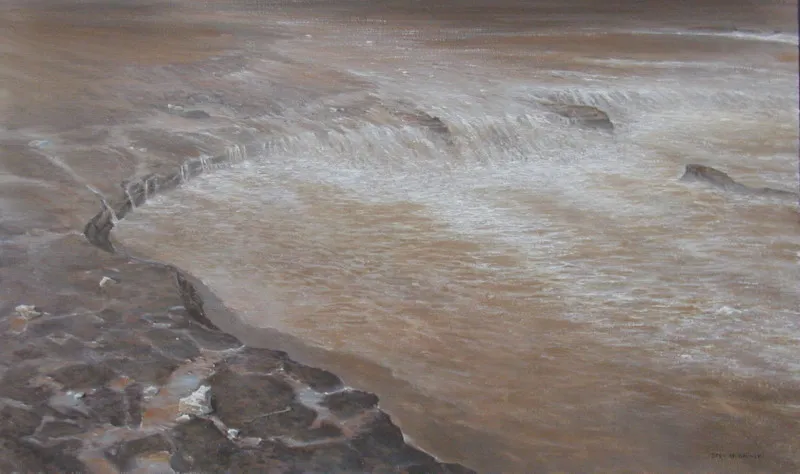
Dry Falls Narratives
Click here for a Brief Ice Age Floods Introduction Dry Falls Stories Dry Falls: The Ghost of a Giant You are standing at the edge of a ghost. Stretching for nearly three miles across and dropping more than 400 feet into the coulee below, this is Dry Falls. Today, it is a silent, sun-baked cliff of basalt, but 15,000 years ago, it was the site of the most spectacular waterfall on the planet. To put its scale in perspective, Dry Falls is nearly five times wider than Niagara Falls and more than twice its height. If you could step back in time, the roar of the water here would be so loud you would feel it in your bones, and the mist would rise miles into the atmosphere. The story of Dry Falls is the story of water on a grand scale that defies modern imagination. During the Ice Age, when the massive ice dams in Montana failed, the released floodwaters poured across eastern Washington. As the floods entered the Upper Grand Coulee, they surged toward this precipice. At the peak of these floods, the volume of water thundering over this cliff was greater than the combined flow of every single river on Earth today. As the water poured over the edge of the precipice, it created massive “plunge pools” at the base, some 400 feet below, which are now filled with the deep, blue lakes you see in the distance. Yet the surface of the flood waters showed barely a crease. The roiling force of the mud-saturated water ripped basalt bedrock off the face of the falls, layers of lava that had cooled millions of years prior. This process had caused the precipice that had begun miles downstream to retreat, migrating upstream to create the massive, crescent-shaped vertical walled amphitheater that spreads out before you. For decades, the origin of this place was a mystery. A geologist named J Harlen Bretz was the first to argue that only a “Great Flood” could have created such a feature. At the time, his ideas were considered radical and were rejected by the scientific establishment, who believed the Earth’s surface only changed through slow, gradual processes. Bretz spent years exploring the Scablands, pointing to Dry Falls as his “smoking gun.” He argued that there was no river currently in the area capable of carving a three-mile-wide canyon, and therefore, it must have happened suddenly. Eventually, the evidence became undeniable, and the landscape proved him right. Dry Falls stands today as the world’s most compelling evidence for catastrophic flooding—a reminder that our Earth can be reshaped not just over eons, but in a matter of terrifying days. The story of Dry Falls is a story of geological wonder and scientific triumph. The Ice Age Floods Institute is dedicated to sharing the science behind these sites and the legacy of pioneers like J Harlen Bretz. We are a volunteer-supported organization, and we need your help to continue our mission of discovery. By becoming a member, you help us preserve the history of the “Greatest Floods on Earth.” Tap the link on your screen to learn more or to make a donation. Thank you for being a part of the IAFI journey. Cataratas Secas: El Fantasma de un Gigante Estás parado al borde de un fantasma. Con una extensión de casi cinco kilómetros de ancho y una caída de más de 120 metros hacia el cañón que se abre abajo, esto es Dry Falls, o las Cataratas Secas. Hoy, es un acantilado de basalto silencioso y castigado por el sol; pero hace 15,000 años, fue el sitio de la cascada más espectacular del planeta. Para poner su escala en perspectiva: Dry Falls es casi cinco veces más ancha que las Cataratas del Niágara y más del doble de su altura. Si pudieras retroceder en el tiempo, el rugido del agua aquí sería tan fuerte que lo sentirías en tus huesos, y la bruma se elevaría kilómetros hacia la atmósfera. La historia de Dry Falls es una historia de agua a una escala tan grandiosa que desafía la imaginación moderna. Durante la Edad de Hielo, cuando las masivas represas en Montana fallaron, las aguas liberadas se derramaron por todo el este de Washington. Al entrar en el cauce superior del Grand Coulee, los torrentes surgieron hacia este precipicio. En el punto máximo de estas inundaciones, el volumen de agua que tronaba sobre este acantilado era mayor que el flujo combinado de cada uno de los ríos que existen hoy en la Tierra. Mientras el agua caía por el borde, creó enormes pozas de inmersión en la base, a unos 120 metros de profundidad, las cuales hoy están ocupadas por los lagos de azul profundo que ves a lo lejos. Sorprendentemente, la superficie del torrente era tan profunda que apenas mostraba una ondulación al pasar sobre el borde. La fuerza turbulenta del agua saturada de lodo arrancó el lecho rocoso de basalto de la cara de las cataratas —capas de lava que se habían enfriado millones de años atrás—. Este proceso causó que el precipicio, que originalmente comenzó kilómetros río abajo, retrocediera, migrando corriente arriba para crear el enorme anfiteatro de paredes verticales en forma de media luna que se extiende ante ti. Durante décadas, el origen de este lugar fue un misterio. Un geólogo llamado J Harlen Bretz fue el primero en argumentar que solo una “Gran Inundación” podría haber creado tal característica. En su momento, sus ideas fueron consideradas radicales y rechazadas por la comunidad científica, que creía que la superficie de la Tierra solo cambiaba mediante procesos lentos y graduales. Bretz pasó años explorando las Scablands, señalando a Dry Falls como su “prueba irrefutable”. Argumentó que no había ningún río en el área capaz de tallar un cañón de cinco kilómetros de ancho, y por lo tanto, debió haber ocurrido de repente. Eventualmente, la evidencia se volvió innegable y el paisaje demostró que tenía razón. Dry Falls se mantiene hoy como la evidencia
Shorelines in the Sky

Click here for a Brief Ice Age Floods Introduction Missoula StrandlinesShorelines in the Sky Take a moment to look closely at the hillsides surrounding the city of Missoula. If you look at Mount Jumbo or Mount Sentinel, you’ll see a series of faint, horizontal lines etched into the grass and rock, rising one above the other like the steps of a giant’s staircase. These aren’t roads, and they aren’t cattle trails. You are looking at “Shorelines in the Sky”—the ancient bathtub rings of a lake that no longer exists. 15,000 years ago, if you were standing in this exact spot, you would be nearly two thousand feet underwater. During the last Ice Age, a massive finger of the Cordilleran Ice Sheet moved south into northern Idaho, acting as a colossal dam that blocked the Clark Fork River. With its only exit blocked, the water backed up into the valleys of western Montana, creating Glacial Lake Missoula. This lake was enormous, covering over 3,000 square miles. The lines you see on the hillsides are “strandlines,” created by wave action. When the lake level stabilized for a period, waves lapped against the mountainside, eroding the rock and soil to create a flat shoreline bench. Because the ice dam was unstable, the lake was never a permanent fixture. When the water became deep enough—such as those highest lines you see near the mountaintops—the pressure would eventually cause the ice dam to fail. The lake would drain catastrophically in just a few days, sending an Ice Age Floods wall of water roaring toward the Pacific. But once the lake was empty and the ice was still moving south, the glacier would move back into place, the dam would reform, and the lake would begin to fill once more. Each time the lake rose to a new level and stayed there for a while, it carved a new strandline. There are over 30 distinct lines visible on these hills, serving as a visual record of at least how many times the lake refilled. These quiet lines are the “smoking gun” of the Ice Age Floods; they prove that Glacial Lake Missoula existed and that it was deep enough to trigger the massive floods that reshaped Washington and Oregon hundreds of miles downstream. From this vantage point, you aren’t just looking at a mountain; you are reading a history book written in stone and earth. The Ice Age Floods Institute is a non-profit organization that works to connect the dots between these shorelines in Montana and the carved canyons of the coast. Our mission is to educate the public about this interconnected geologic story. We invite you to join us as a member or a donor. Your contributions help us maintain these interpretive markers and support regional geology programs. Please visit IAFI.org or click the link on your screen to support the story of Glacial Lake Missoula. Líneas sobre Missoula: Orillas en el cielo Tómate un momento para observar detenidamente las laderas que rodean la ciudad de Missoula. Si diriges tu mirada hacia el Monte Jumbo o el Monte Sentinel, notarás una serie de líneas horizontales tenues grabadas en la hierba y la roca. Se elevan una sobre otra como los escalones de una escalera construida para un gigante. No son caminos trazados por el hombre ni senderos para el ganado. Lo que estás viendo son las “Orillas en el Cielo”: las marcas de una tina de baño antigua pertenecientes a un lago que ya no existe. Hace 15,000 años, si estuvieras parado en este mismo punto, te encontrarías bajo casi 600 metros de agua helada. Durante la última Edad de Hielo, un dedo masivo de la capa de hielo de la Cordillera se desplazó hacia el sur, bloqueando el río Clark Fork y creando el gigantesco Lago Glaciar Missoula. Este lago era una fuerza de la naturaleza, cubriendo más de 7,700 kilómetros cuadrados de valles montañosos. Las líneas que ves hoy en las laderas se conocen como “líneas de costa” o strandlines, y fueron esculpidas por la acción constante de las olas. Cuando el nivel del lago se estabilizaba durante un tiempo, las olas golpeaban la ladera, erosionando la roca y el suelo hasta formar un escalón o terraza nivelada. Debido a que la represa de hielo era inherentemente inestable, el lago nunca fue permanente. Cuando el agua alcanzaba una profundidad crítica, la presión hidrostática levantaba el hielo y provocaba una falla catastrófica. El lago se vaciaba en pocos días, enviando una pared de agua rugiendo hacia el Océano Pacífico. Pero una vez que el lago quedaba vacío y mientras el glaciar seguía empujando hacia el sur, la represa se reformaba y el ciclo de llenado comenzaba de nuevo. Estas líneas silenciosas son la “prueba irrefutable” de estos Torrentes Geológicos; demuestran que el Lago Missoula fue real y lo suficientemente profundo como para desatar el caos cientos de kilómetros río abajo. Desde este punto de vista, no solo ves una montaña, sino que estás leyendo un libro de historia escrito en piedra y tierra. El Instituto de las Inundaciones de la Edad de Hielo trabaja para conectar estos puntos entre Montana y la costa. Te invitamos a apoyarnos como miembro o donante visitando IAFI.org. Audio Introduction to the Introducción en audio a las
2025 IAFI YEAR-IN-REVIEW

We normally include a review of our past year’s activities in our January newsletter for our members and interested others, but that newsletter was just too overfull with other important news. Our 2025 Year-In-Review below was compiled January 30, 2026.This is our 9th year preparing a Year-in-Review report for you, our members. We appreciate your continued support, friendship and membership. INSTITUTE MEMBERSHIP – Our members provide most of our support and much of the reason for the various materials, activities and events we provide. In 1996, we started with 11 members. At the end of 2025, we have 583 members (446 memberships). Our members come from the following states: Washington (67%), Oregon (15%), Idaho (7%), Montana (5%) with smaller amounts from CA, NV, AZ, WY, TX, AK, NM and OK, Canada and Germany. INSTITUTE BOARD ACTIVITIES – IAFI work activities that occur at both the Institute Board of Director level and at the Chapter level generally benefit the entire organization. Listed below are some of these activities. The Board works closely with the National Park Service Program Manager for the Ice Age Floods National Geologic Trail. We have a formal partnership agreement and work cooperatively to further the missions of both organizations. The Education Committee, in partnership with IAFL-NGT and Engaging Every Student, has developed a curriculum program for our 4 state region, “Ice Age Floods Detectives”, of 4 one-hour lesson plans focused on a 4th grade audience. The Education Committee also developed a K-12 Grant program to provide funding to teachers and students for field trips, lab supplies, and to provide funds for other ancillary needs that will enhance implementation of the curriculum. The Cheney-Spokane Chapter established a Student Research Grant program that covers the entire institute area. It recently awarded its first grant The Membership Committee created a Floods Photo of the Week program which provides photos of features throughout the four-state area for all our members. Our webmaster keeps the website (iafi.org) fresh and stimulating. He also, with support from the chapters, issues the Pleistocene Post Newsletter four times a year. Our Membership Manager provides quarterly reports on member/memberships for all chapters and the institute. She responds to membership queries, resolves problems and keeps records current. Our IAFI Treasurer works with our Certified Public Accountant who maintains all our financial records and provides monthly reports to the Board. Our IAFI Store Manager provides service to our members by stocking and processing orders for the most recent books, maps, etc related to the ice age floods. ANNUAL MEMBERSHIP MEETING – This year the annual IAFI membership meeting and field trip was held hosted by the Columbia River Gorge Chapter and there. Approximately 146 people attended the event. Click here for a reflective review of the event. 2025 CHAPTER PROGRAMS – Outreach to inform and educate the public about the Ice Age Floods and their long-lasting impact on our area is a key part of the IAFI mission. Our local chapter programs are possibly the most effective way we meet this challenge. Three of the more important ways we help people learn about the Ice Age Floods are with lectures, field trips and hikes. LECTURES – In 2025 we had 37 lectures attended by over 1549 people. Many more people viewed lectures when they were posted on YouTube. FIELD TRIPS- In 2025 we conducted 22 field trips with 735 attendees. HIKES – In 2025 three chapters sponsored 7 hikes with 106 attendees. PRESENTATIONS TO K-12 STUDENTS Columbia River Gorge chapter – talk and 2 field trips for Hood River New School and a talk for Hood River Elementary 4th grade classes Cheney–Spokane Chapter – Jefferson Elementary School STEM Expo requested that the IAFICS Chapter staff an educational booth on the Ice Age floods. The booth was so popular with the kids and their parents that our chapter was asked to participate in a follow up at the Westview Elementary School STEM Expo. The IAFICS Chapter was contacted by Spokane City Councilman Zack Zappone, requesting a talk and short hike for the North Central Middle School. Lake Lewis Chapter – A number of members helped with education programs at The Coyote Canyon Mammoth Site (MCBONES) near Kennewick. Palouse Falls Chapter: talk and presentation to Pomeroy Home School. Lower Grand Coulee Chapter: Assisted with a presentation at the Ice Age Floods Fest at Dry Falls aimed at educating children on the Ice Age Floods story (350+ attendees). INVOLVEMENT WITH PROFESSIONAL ORGANIZATIONS AND UNIVERSITIES Cheney–Spokane Chapter – Dr. Isaac Larsen (Univ. Massachusetts), accompanied by a graduate student, requested a three-day field trip to collect flood ice-rafted erratics and in-situ exposure for exposure dating of the glacial floods in the Spokane and Vantage areas. Drs. Jim O’Connor and Lydia Staich (USGS) requested a two-day research field trip to look at historical till and flood sites on the Spokane Indian Reservation southeastward to Reardan and Spokane-Mica area. All chapters routinely recruit knowledgeable speakers from universities or state/federal agencies to ensure we are presenting the most current scientific information to our members. PRESENTATIONS AT COMMUNITY EVENTS Cheney-Spokane Chapter – Great Outdoor Sports Expo requested that the IAFICS Chapter staff an educational booth on the Ice Age floods. Don Chadbourne and nine enthusiastic chapter volunteers manned the booth which had heavy traffic on both days. Over 100 people stopped by the booth to get information on our upcoming events and pick up brochures providing information on local flood features and the National Geologic Trail. For the second year the Spokane County Library System asked the Cheney-Spokane chapter to provide speakers for four library branches. All four talks filled the rooms. The Turnbull National Wildlife Refuge asked the chapter to staff a booth and lead a hike. Columbia River Gorge Chapter – Gorge History Museum talk. Nature Conservancy talk at Rowena Crest . Co-led a number of field trips sponsored by the Columbia Gorge Naturalist Program. Coeur Du Deluge Chapter – Again led programs for the Idaho Master Naturalists. Interviewed for Sandpoint Magazine (Summer 2025). Ellensburg Chapter: had information booths at two Ellensburg Farmers Markets. Spoke with about
Introducing IAFI’s K-12 Education Grant Program
Empowering Teachers to Share the Ice Age Floods Story with Students Mini-grants of up to $500 now available for K-12 educators Open Application Period The Ice Age Floods Institute is proud and excited to announce a groundbreaking initiative to bring one of Earth’s most dramatic geological stories into classrooms across the Pacific Northwest. Our new K-12 Education Grant Program provides targeted funding to help teachers and students explore, understand, and share the remarkable Ice Age Floods narrative with their communities. The Challenge We’re Addressing The Ice Age Floods story may seem straightforward to those who’ve studied it, but explaining these catastrophic events to newcomers can be surprisingly complex. Teachers need effective guidance and quality materials to bring this geological phenomenon to life in their classrooms. Students who become fascinated by the floods can inspire others. IAFI recognizes that reaching K-12 students is one of the most effective ways to educate young people, and through them to share this incredible story with their families and communities. Our Mini-Grants Solution: Grants up to $500 That Make a Difference These carefully designed mini-grants help defray the costs of materials, field experiences, and project development for classroom instruction throughout Idaho, Montana, Washington, and Oregon. By providing this crucial support, we’re creating a ripple effect of interest and knowledge that extends from students to their families and friends. How Grants Can Be Used We’ve designed this program with flexibility in mind, understanding that teachers and students have diverse needs and creative approaches to sharing the Ice Age Floods story. These grants are meant to support classroom activities including curriculum materials, educational supplies, guest speaker fees, and field trip expenses to Ice Age Floods sites throughout the Pacific Northwest. The Power of Student Engagement When students develop genuine interest and excitement about the Ice Age Floods, they become natural ambassadors for the story. They share their enthusiasm with family members over dinner, explain geological concepts to friends, and carry this knowledge forward throughout their lives. This program doesn’t just fund classroom teachers—it creates a generation of informed advocates for geological education, research and preservation. What Makes This Program Special Our grant program initially focuses on 4th grade educators in support of the IAFI 4th Grade Curriculum Project. This strategic approach allows us to build a strong foundation before expanding to all K-12 teachers and students in future years. It’s For Educators Teachers can apply for funding to enhance their Ice Age Floods curriculum through: Classroom materials and educational resources Field trip expenses to visit actual flood-carved landscapes Hands-on demonstrations and interactive activities Professional development opportunities Some Useful Teaching Resources Big Water Is Coming (PDF) – A children’s book illustrating the possible reactions and impact on animals in the path of a Flood NPS-IAFloods Animated Video (narrated) – A short National Park Service animated and computer-voice narrated video about the floods NPS-IAFloods Animated Video (unnarrated) – The same short National Park Service animated video about the floods, without narration An Ice Age Floods Story Introduction – A brief teacher’s guide elementary grade-level introduction to the Ice Age Floods. Simple Application Process We’ve designed our process to be straightforward and educator-friendly. Applications are accepted year-round starting January 2026, with a two-month review period. Once approved, recipients have one year to complete their projects, followed by a six-month window to share their results with the IAFI community. Educators can use the online application below to get started. Join Us in Making Floods History Come Alive This Scholar Support Grant Program represents more than just funding—it’s an investment in geological literacy, scientific curiosity, and the preservation of our region’s remarkable natural heritage. By supporting teachers and students as they explore the Ice Age Floods, we’re ensuring that this incredible story continues to inspire wonder and understanding for generations to come. Get Involved – YOUR support directly impacts the next generation Whether you’re an educator ready to apply or a potential donor, an individual member, local business, organization committed to education, or simply curious to learn more, we invite you to be part of this exciting initiative. Contact us at IAFIGrants@gmail.com. And your donation will help ensure that more students and teachers can access the resources they need to share the Ice Age Floods story effectively. Donate tax-deductible and fee-free either through our Zeffy Fundraiser (***note: Zeffy’s “tip” request is optional***) or mail a tax-deductible donation directly to: IAFI K-12 Educator Grant Program, 1440 SW Brislawn Loop Rd. White Salmon, WA 98672. $5,000 Annual IAFI Program Funding Commitment and Growth The program is initially funded by the Ice Age Floods Institute and our 11 local chapters with a $5,000 annual commitment to support multiple projects each year. We’ve received over $1600 in additional donation support from IAFI members and the Bellevue Rock Club. Thank you all. We’re committed to continue growing this program through donations from IAFI members, businesses, educational grants, and other philanthropic sources. We anticipate significant interest from current members and believe that a successful grant program will help attract new supporters to IAFI’s mission. Grant Cycle Applications will be accepted on an ongoing basis. Grant awards will be approved and announced within 2 months of application and 90% of an grant will be awarded upon approved. The awarded grant must be used and a final report shared with IAFI within 12 months – the final 10% of of the grant will be awarded after completion of these requirements. Questions? Email us at IAFIgrants@gmail.com
Telling the Story of the Missoula Floods
Developing an Ice Age Floods Animation Through Science, Partnership, and Interpretation Explaining the Missoula Floods has never been simple. The floods reshaped landscapes across much of the Pacific Northwest, yet they occurred thousands of years ago, unfolded repeatedly rather than once, and operated on a scale that is difficult to grasp from any single viewpoint. While physical evidence of flooding is visible in coulees, erratics, and sediment deposits across the region, understanding how those features formed requires connecting processes that span vast distances and long periods of time. For the Ice Age Floods National Geologic Trail, this challenge sits at the center of its mission. The Trail links flood-related sites across four states and relies on partnerships with parks, museums, educational institutions, Tribes, and communities to interpret a story that is regional in scale and national in significance. Developing a shared, accurate way to tell that story has been a long-standing goal. One important step toward that goal is the release of a new Ice Age Floods animation, now publicly available through the Pleistocene Post for the first time ever through the National Park Service and the Ice Age Floods Institute. Understanding the Missoula Floods—and Why Animation Was Essential The Missoula Floods were not a single catastrophic event. They occurred dozens of times as an ice dam repeatedly formed and failed during the last ice age. Each flood released immense volumes of water, carving the Channeled Scablands, transporting massive boulders, and depositing thick layers of sediment across the Columbia Basin, the Willamette Valley, and beyond. These repeated events reshaped landscapes on a scale that is difficult to grasp from any single location or landform. This combination of repetition, scale, and process presents a fundamental interpretive challenge. Static maps, photographs, or diagrams can show where flooding occurred, but they struggle to convey where ice dams formed and failed, why floods happened repeatedly, and how those repeated events shaped the landforms we see today. Visitors often encounter individual features—such as coulees, erratics, or sediment deposits—without an intuitive sense of how those features connect to a larger, system-wide story. Animation offers a way to bridge that gap by showing movement, change, and sequence over time. It makes it possible to illustrate how ice dams failed, how floodwaters moved across vast landscapes, and how erosion, transport, and deposition shaped the region over thousands of years. By showing sequence and scale together, the animation provides context that static interpretation often cannot. At the same time, animation carries risks. Visual storytelling can unintentionally oversimplify complex processes or imply certainty where scientific understanding includes ranges and ongoing inquiry. Addressing those risks required careful collaboration and review to ensure the final product communicates current scientific understanding clearly, accurately, and responsibly. A Trail Built on Partnership The Ice Age Floods National Geologic Trail is a partnership-based unit of the National Park Service. Unlike traditional national parks, the Trail does not center on a single land base. Instead, it connects a network of sites, organizations, and communities that collectively interpret the Missoula Floods story across four states. From its earliest days, scientific research and public education about the floods have been advanced by regional partners, particularly the Ice Age Floods Institute, along with academic researchers, museums, educators, and land managers. Federal agencies with expertise in geology, hydrology, and landscape science have also contributed to the evolving understanding of flood processes and landforms. Together, these partners built the scientific foundation and public awareness that ultimately made the Trail possible. That shared foundation shaped how the Ice Age Floods animation was conceived. The project was not approached as a standalone National Park Service product, but as a collaborative effort intended to reflect current scientific understanding while respecting decades of research, publication, and public engagement. Partner involvement helped ensure the animation was grounded in credible science and responsive to the needs of educators, interpreters, and institutions working across the region. Just as important, partners helped shape how the animation would be used. From the outset, it was understood that no single product could replace place-based interpretation. Instead, the animation needed to complement local stories, support diverse interpretive goals, and function as a shared framework rather than a prescriptive narrative. The result is an animation designed to be flexible, modular, and broadly applicable. A Collaborative Development Process Developing the animation was an iterative process involving scientists, interpreters, educators, and media specialists. Expertise in glacial dynamics, flood hydraulics, geomorphology, and interpretation informed each stage of development, ensuring that both scientific rigor and interpretive clarity remained central throughout the project. Drafts were reviewed not only for technical accuracy, but for how audiences might reasonably interpret what they were seeing. Revisions focused on clarity and defensibility—refining pacing so that scale was conveyed without exaggerating velocity, ensuring viewers could distinguish between process and outcome, and reinforcing that the floods occurred repeatedly rather than as a single event. In many cases, refinements were not about correcting facts, but about improving how those facts were communicated visually. The goal was not to resolve every scientific nuance, but to present a version of the story that is accurate, carefully framed, and useful across many interpretive settings. This collaborative approach helped ensure the animation could serve as a reliable interpretive tool while remaining accessible to broad public audiences. What the Animation Is—and Is Not The Ice Age Floods animation is intended to provide a system-scale overview of how the floods worked, support education and interpretation across diverse settings, and serve as a shared visual reference for partners and educators. It is not intended to replace place-based interpretation, resolve all scientific debates, or function as a comprehensive instructional resource on its own. In many cases, individual segments of the animation may be more useful than the full piece. Short sections can illustrate specific topics—such as basalt erosion, flow through constricted valleys, or the cumulative effects of repeated flooding—while local interpreters focus on the features and stories most relevant to their sites. Supporting Education and Public Understanding Now that the animation is publicly available, it
IAFI Store – Winter Inventory Reduction Sale

The IAFI Store is having a special Winter Inventory Reduction Sale to make room available to add new items and updated items as they become available. This is a great opportunity to get Floods-related presents for family, friends, and maybe yourself at (often) steeply reduced prices. And every order will include a free IAFI window decal you can use to let others know you’re passionate about the features and the science behind the cataclysmic Ice Age Floods story. Share the Ice Age Floods story this Christmas! The IAFI Store’s Winter Inventory Reduction Sale is here – and it’s your chance to dive deep and share the story of these spectacular events. We’re making room for exciting new items, which means steep discounts of 10% to over 40% on a selection of Ice Age Floods merchandise. Whether you’re shopping for the Floods enthusiast in your life, a curious student, or treating yourself to something extraordinary, now’s the perfect time to explore the fascinating world of the cataclysmic floods that carved the Pacific Northwest. What Makes This Sale Special? From educational materials that bring ancient catastrophes to life, to unique gifts that celebrate the power of water and ice, our collection offers something for every curious mind. These aren’t just presents – they’re gateways to understanding the massive forces that shaped our landscape thousands of years ago. As an added gift for you, every order comes with a free IAFI window decal – your badge of honor showing you’re passionate about the incredible science behind the Ice Age Floods story. It’s more than just merchandise; it’s a conversation starter about one of the world’s most dramatic chapters. Limited time only. Shop now while inventory lasts and discover why the Ice Age Floods continue to captivate scientists and nature lovers alike. Ready to explore? Visit the IAFI Store today and turn this Christmas into a journey through deep time.
2025 IAFICS Student Research Grant Guidelines
Introduction The primary role of the Cheney-Spokane Chapter, Ice Age Floods Institute (IAFICS) student research grants program is to provide partial support of undergraduate senior thesis and graduate student thesis research on Ice Age floods in the Pacific Northwest at universities in the United States and Canada, by offering $500 grants to help defray field expenses. Students may receive a total of two IAFICS graduate student grants in their entire academic career, regardless of what program they are currently enrolled in. In addition, graduate student research theses/dissertations focusing on Ice Age floods in the Pacific Northwest may also request partial support for lab fees for surface exposure or other dating techniques, not to exceed $27,000. Eligibility To be eligible to apply for the IAFICS Chapter’s Student Research Grant, you must: Be a IAFI Student Member, student fee of $10 online at iafi.org, which must be renewed or active through the end of the award year, which is the same calendar year in which the application deadline occurs. Be currently enrolled as a senior undergraduate engaged in a senior thesis or in a graduate program working toward a Master’s or Doctoral degree. Agree that if you are selected to receive a grant, and if you have a U.S. Social Security Number (SSN) or U.S. Tax Identification Number (TIN), you will provide it to cheneyspokane@iafi.org to facilitate payment of the funds. Must apply as an individual; institutions, societies, and universities are not eligible for grants. Application Submittal Only electronic applications submitted online to the IAFICS Student Research Grants Program Manager (cheneyspokane@iafi.org) will be accepted. Proposals are due by April 15 and must focus on aspects of Quaternary flood geology in the Pacific NW. The application should be concise and should define a research problem of geologic significance. It should detail a research strategy to solve a problem in the field and/or the laboratory. Graduate students may request funds to partially cover lab costs for any essential rock or sediment dating aimed at constraining the timing of Quaternary flooding in the Pacific NW. Details about who and where the preparation and analyses are to be done must be fully addressed, as the IAFICS grant money would be paid directly to the providers as payment for a service. These payments can be made to the providers incrementally as batches of analyses are completed. There is no submittal deadline for those graduates who request only funds for lab dating analysis. Advisor Confirmation/Appraisal of Student’s Academic Status The student applicant is obligated to see that a confidential confirmation of student status from the applicant’s advisor is verbally or electronically sent to IAFICS Student Research Grants Program Manager (cheneyspokane@iafi.org) on or before the April 15 deadline. Advisor appraisal is mandatory or the application will not be accepted. Time Schedule The recipient must commence the project as stated in their proposal and continue it diligently throughout the stated duration of the investigation. If the recipient is unable to complete the work within the timeframe stated in the proposal, the Cheney Spokane IAFICS Research Grants Program Manager should be notified in writing. Progress Report A progress report and photos are due to the IAFICS Student Research Grants Program Manager (cheneyspokane@iafi.org) by March 1 of the year following the award. Publication of Results The committee encourages publication of results in a scientific journal and presentation of results at a professional meeting. The IAFI Cheney Spokane Chapter should be acknowledged for its support in thesis/dissertation and publication. We encourage the reporting of the thesis and PDF copy of publications back to the IAFICS Research Grants Program Manager. Return of Funding If the recipient is unable to undertake or complete the project, the recipient must return any unused portion of the grant to the Ice Age Floods Institute Cheney Spokane Chapter immediately. If the recipient receives substantial funding from another source for specific items budgeted in their IAFICS student research grant proposal, the IAFICS Research Grants Program Manager should be notified immediately. Funds returned to the Institute will be re-awarded promptly to alternate recipients who have been selected by the Committee on Student Research Grants. Taxation For field work grants, all individuals with a U.S. Social Security Number (SSN) or U.S. Tax Identification Number (TIN) must provide it to IAFICS in order to receive a grant payment. This includes all U.S. Citizens, all U.S. Resident Aliens, and some other individuals. This requirement is in accordance with the U.S. Internal Revenue Service (IRS); failure to comply will result in no grant being awarded to the individual. If awarded a grant, this money may be taxable by the IRS. The IAFICS Chapter is required to issue 1099 forms at the end of each calendar year according to rules set by the IRS. Issuance of a 1099 does not necessarily mean the income is taxable to the recipient–the recipient must make that determination, which may require the services of a professional tax accountant. The IAFI cannot offer tax advice. (Please note that an SSN or TIN is not required to apply; but everyone who is selected to receive a grant and who has an SSN or TIN must provide it to the IAFICS.) Application Evaluation The student submitted applications for $500 grants to help defray field expenses are received by the IAFICS Student Research Grants Program Manager and are forwarded to the board members on the Committee for reviewing Student Research Grants and they are responsible for evaluating and ranking the proposals on the basis of their scientific merits, the practicability of each project, the qualifications of the applicant for the proposed investigation, the reasonableness of the budget, and other pertinent data. There is no policy favoring small or large projects. The scientific merit of the research is weighed against the cost, in competition with other requests. Evaluation of each Student Research Grant proposal is based on the following: A clearly defined statement of scientific significance. Description of fieldwork or lab work expenses including budget justification. Advisor confirmation/appraisal of the student applicant. Committee Actions
Inspire New Generations
with the Ice Age Floods Story Help bring one of North America’s most dramatic geological events into Pacific Northwest classrooms Join Us in Making an Impact Help students discover the powerful forces that shaped our region’s landscape The Ice Age Floods Story The Ice Age Floods carved spectacular landscapes across Washington, Oregon, Idaho, and Montana—creating the dramatic geology we see around us today. The landscape of the Pacific Northwest tells a powerful story of earth-shaking forces—but does our next generation know how to read it? The IAFI K-12 Education Grant Program The Ice Age Floods Institute is launching a new K-12 Education Grant Program empowering teachers to take students beyond the textbook to explore the science in the classroom and field. Grants of up to $500 will give educators the resources they need to spark curiosity about the landscape before their eyes and beneath their feet. Now, through the IAFI K-12 Education Grant Program, you can help students experience this incredible story firsthand. Building for the Future Our pilot program launches with $5,000 in seed funding from IAFI and our 11 local chapters. The program will initially focus on 4th grade classrooms in support of with our new IAFI 4th Grade Curriculum Project. With your support, we can expand the program to serve students throughout K-12 grades across the region—creating a lasting educational legacy. $500 Maximum Grant per Educator 100% of Funds Go to Help Students Why This Program Stands Out Our K-12 Education Grant Program and your donations will help empower educators to enhance Ice Age Floods curriculum with: Field trips to flood-carved landscapes where students can read the story written in the rocks Classroom materials and educational resources that make complex geology accessible Hands-on demonstrations and interactive activities that spark curiosity Professional development opportunities for educators Geographic Reach Priority is given to schools in the core Ice Age Floods impact zones across Washington, Oregon, Idaho, and Montana. We also welcome applications from the broader region for educational initiatives related to the Ice Age Floods. How Your Gift Powers Discovery Every dollar you donate directly supports hands-on learning experiences. Our team donates grant administration, and through our partnerships with Zeffy and PayPal Giving Fund there are zero processing fees, so your entire donation will go to work to fund classroom materials, interactive activities and field trips that bring the Ice Age Floods and science to life. Donate to the IAFI K-12 Education Grant Program Zeffy Fundraiser payPal Giving Fund Your Support Makes a Difference Donated administration by our all-volunteer team and our partnerships with Zeffy and PayPal Giving Fund eliminate processing fees and ensure maximum impact, so your full donation directly fuels student discovery. Together, we’re not just teaching the Ice Age Floods story—we’re inspiring young people to share this remarkable story with their families and communities. Questions? Email us at IAFIgrants@gmail.com Help expand the program, donate fee-free with several payment options through our Zeffy Fundraiser or PayPal Giving Fund links Our fiscal sponsor, IAFI Columbia Gorge Chapter, is a federally registered 501(c)(3) non-profit organization. Your donation may be tax deductible
IAFI K-12 Grant Program Donation Successful
Congratulations! Your IAFI K-12 Grant Program donation completed successfully You will receive an email confirmation from PayPal Giving Fund Thank you for your generosity in helping K-12 students learn and share the remarkable story of the ICE AGE FLOODS with others