Museum of Natural History, University of Oregon
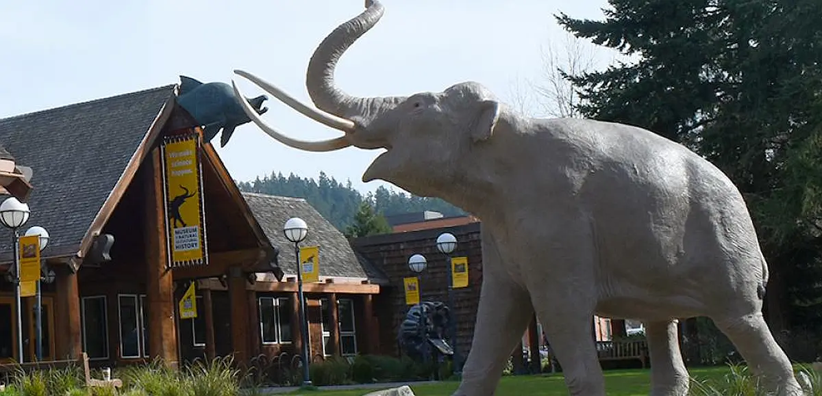
Museum of Natural and Cultural History, University of Oregon The museum offers a variety of seasonal and year-round programs for science and culture enthusiasts of every age. Delve into Oregon’s story, from the archaeology of the First Americans to the dynamic cultures of today’s Tribes. Experience the dynamic forces that shape Oregon’s landscapes, climate, and ecosystems. Meet giant salmon, Ice Age sloths, and other amazing animals from across the millennia. Museum initiatives steward Oregon’s past, present, and future. The museum is home to an invaluable record of Earth’s environments and cultures. As the state’s official repository for Oregon cultural and paleontological materials, our vaults house hundreds of thousands of objects ranging from archaeological and ethnographic items to fossils and geological specimens. The museum also curates extensive zoological and zooarchaeological collections used for comparison and identification of specimens from paleontological and cultural sites. Together, the collections inspire wonder, stewardship, and scholarship in Oregon and beyond. New discoveries constantly reshape our shared understanding of Earth’s natural and cultural histories. Explore the museum’s ongoing research in paleontology and archaeology, and learn how scholars from around the world are using our collections in their research. Website: https://mnch.uoregon.edu/ Hours: Wednesdays through Sundays 10:00 a.m. to 5:00 p.m., Thursdays until 8:00 p.m Entry Fees:•General: $6•Seniors (62+) & Youths (3-18): $12•Families (up to 2 adults and 4 youths): $12•Children (2 and under), UO students, LCC students, faculty, staff*, MNCH members: FreeVeterans and active-duty military*: Free Location:1680 East 15th AvenueEugene, OR 97403
Moses Coulee: Unveiling the Mystery of a Colossal Ice Age Scar
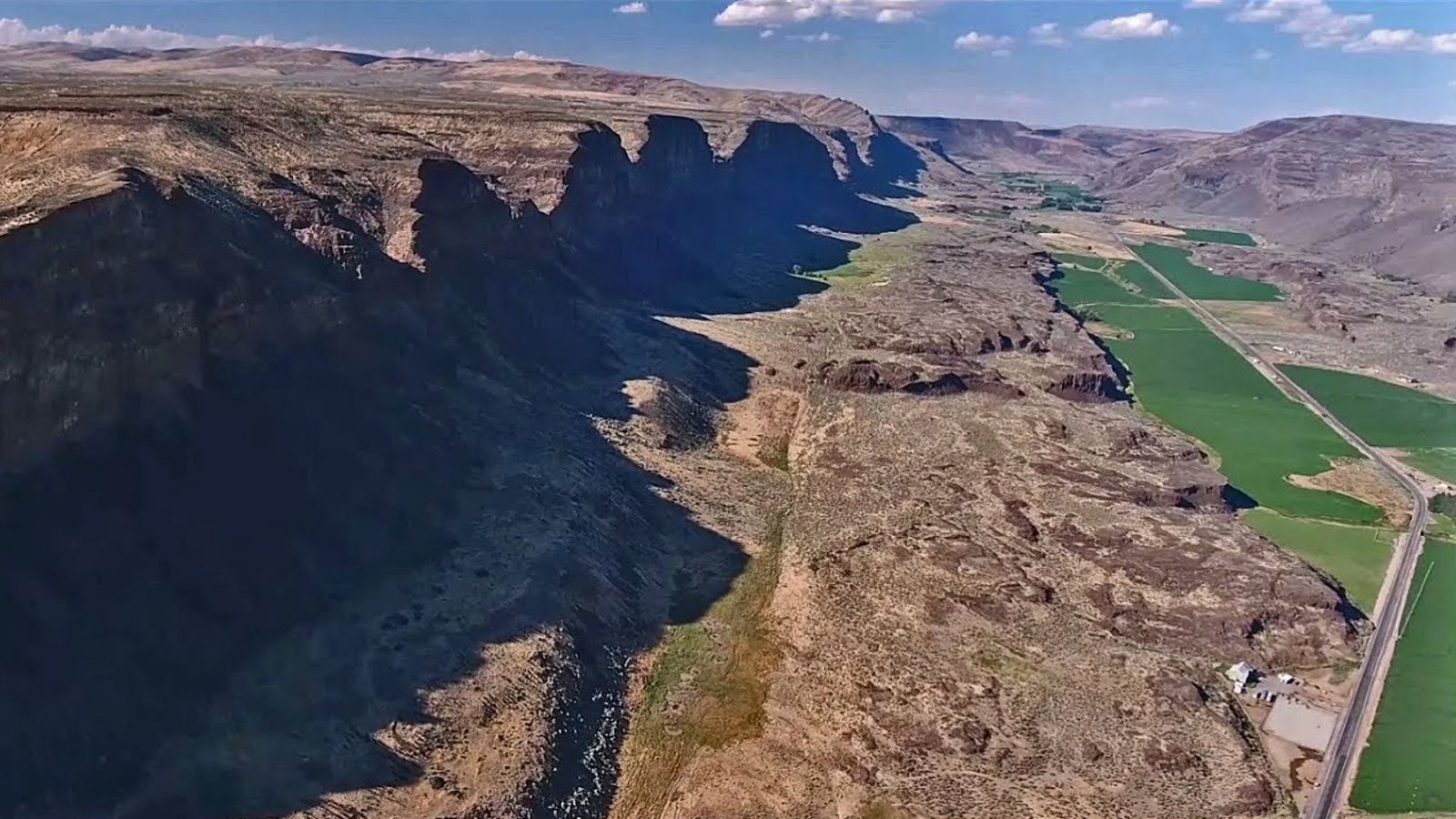
Moses Coulee, a Washington state wonder, has puzzled geologists for over a century. This massive canyon, carved into solid basalt, stands as a testament to some powerful force. The culprit? The Ice Age Floods, a series of catastrophic deluges that reshaped the landscape. If you’ve ever visited, or even just passed through Moses Coulee, you may not have been aware that this awe-inspiring coulee has been an Ice Age Floods conundrum since the time geologist J Harlen Bretz first noted it in 1922. The problem? Moses Coulee doesn’t quite fit the picture. As Bretz described it, “The head of Moses Coulee is just north of Grimes Lake. It is an abrupt termination, walled by 100 foot cliffs, identical with the features of channeled scabland which are called abandoned cataracts.” The head of the coulee ends abruptly, lacking any clear connection to the known flood paths. Theorists proposed a missing link, a path obliterated by the Okanagan Ice Lobe, but no evidence of such a grand passage has ever been found. The mystery has persisted and become more enigmatic as Ice Age Floods research has flourished over the years: what colossal force carved this immense coulee? A new study by Gombiner and Lesemann (Geology, 2024) offers a radical new hypothesis. They propose a surprising source for flood waters: meltwater trapped beneath the massive Okanagan Ice Lobe glacier. Imagine the giant Okanagan ice sheet pressing down on the Waterville Plateau. Meltwater pooled in valleys beneath the ice, trapped and pressurized. This water, according to the theory, found a surprising escape route. Flowing through a network of hidden channels, it carved its way across intervening ridges and valleys, eventually funneling into Moses Coulee. This “tunnel channel network,” as the researchers describe it, explains the unusual path of the water. The channels themselves, carved in basalt, climb slopes and defy normal drainage patterns. These features, along with glacial landforms like eskers, suggest a watery escape route beneath the ice sheet. The study doesn’t rule out the role of traditional Ice Age Floods. Water from massive glacial lakes might have also contributed to Moses Coulee’s formation by flowing along the eastern edge of the glacier. This new hypothesis could be a game-changer. It suggests a hidden world of pressurized meltwater sculpting the landscape beneath the ice. While the debate continues, one thing is certain: Moses Coulee remains a captivating enigma, a place where the power of water and ice continues to unfold its secrets.
Visit Wenatchee, Washington – Explore Ice Age Flood Features

Wenatchee, Washington is often called the “Apple Capital of the World” or the “Buckle of the Power Belt of the Pacific Northwest”. Today the Wenatchee vicinity is known for the fruit industry, wineries, power generation, tourism and outdoor recreation. When you visit and look around the Wenatchee Valley, even today, much of the landscape was formed by Ice Age Flooding. Visit the Wenatchee Valley area to explore some of the interesting Ice Age Flood features found there. Toward the end of the Pleistocene Ice Ages (17,000-12,000 years ago) much of the landscape in the Wenatchee area was changed substantially by catastrophic ice-age flooding. These flood(s), almost 1,000 feet deep, initiated out of glacial Lake Missoula in Montana, and some of the largest came through the Wenatchee area along the Columbia River drainage. Prior to the Okanogan Ice Lobe blocking the Columbia River valley north of Wenatchee, the early Missoula flood(s) could follow the present day path of the Columbia River around the “Big Bend” area of north-central Washington into the Wenatchee area and further south. Take a drive north of Wenatchee on highways US 97 or US 97A to see evidence of this flooding. As the Okanogan Ice Lobe advanced south it eventually blocked the Columbia River drainage north of Wenatchee. The water backed up by that Okanogan Lobe ice dam formed glacial Lake Columbia and forced subsequent ice-age floods to be funneled southward along the east edge of the ice lobe into Moses and Grand Coulees, and farther east through the Channeled Scablands of eastern Washington. When the Okanagan ice eventually retreated, one last flood from glacial Lake Columbia again followed the Columbia drainage through Wenatchee. Massive boulders (some 40 feet in diameter) and erratics (rocks foreign to the area) were transported at the base of the flood waters and embedded in huge icebergs floating on the floodwaters. They were deposited along the hillsides throughout the Wenatchee area as the floods waned and the icebergs became stuck and melted. Those erratics prompted our Ice Age Floods Institute chapter name “The Wenatchee Valley Erratics”. The two main erratic rock types in this area, granite and gneiss, are much different from the Eocene Chumstick Sandstone bedrock. The gneiss erratics transported a relatively short distance from outcrops just north of Wenatchee are often 10 feet in diameter. The nearest granite outcrops occur some 15 miles upstream in the Entiat area, so the granite erratics tend to be smaller, less than 3 feet in diameter. Some of the best locations to see these erratics are just south of the Old Wenatchee Bridge (first bridge over the Columbia River finished in 1908) along the Apple Capital Loop Trail near Patriot Plumbing & Heating, the Department of Social & Health Services and near the old train at Mission Street Park in south Wenatchee. An enormous crescent-pendant Pangborn Bar topped with huge current ripples was deposited in east Wenatchee where the Columbia River drainage takes a right (easterly) turn. The bar elevation is 500 feet above the Columbia River today. On the surface of Pangborn Bar are giant current ripples with crests up to twenty feet tall and ripples spaced some 300 feet apart. Travel up Grant Road, 4th Street in East Wenatchee and then out onto Batterman Road northwest of Rock Island to travel across the entire Pangborn Bar from west to east. The giant current ripples are best observed on 2nd or 4th Streets, where these roads go up and over the current ripples east of Nile Avenue in East Wenatchee, Washington. Just about a mile northeast of Pangborn Memorial Airport is a very significant archaeological site, the East Wenatchee Clovis Site (Richey Clovis Cache), discovered in 1987 and excavated until the site was closed and covered in 2004. This site lies on top of one of these current ripples. Pristine Clovis spear points as well as other archaeological specimens (about 11,000 years old) were discovered and some are now on display at the Wenatchee Valley Museum and Cultural Center in Wenatchee. Article from Brent Cunderla, April 2024
Postmortem on the southern Cordilleran Ice Sheet

(21Feb2024) On 18 March 2924 at 7:00pm the Puget Lobe Chapter io the IAFI will have Dr Ralph A Haugerud give his presentation “the Postmortem on the Southern Cordilleran Ice sheet. Death of an ice sheet can have many causes, as shown by retreat of the southern Cordilleran ice sheet about 15,000 years ago. East of the Cascades, the margin of active south-flowing ice retreated north as less snow fell and more melted. West of the Cascades, the Juan de Fuca lobe of the ice sheet appears to have floated away in response to rising sea level, perhaps without a proximal climatic cause. Collapse of the Juan de Fuca lobe diverted ice from the Puget lobe, which consequently stagnated at its margin and rapidly melted back. Later Sumas ice readvance in the Fraser Lowland may reflect stabilization of the remnant ice sheet by grounding as local sea level fell, followed by climate-driven retreat. Ralph Haugerud received B.S. and M.S. degrees in Geology from Western Washington University and a Ph.D. in Geological Sciences from the University of Washington. Since joining the USGS in 1986, he has worked in the North Cascades Range, the Salish Lowland, and the Columbia Plateau. From 1990 to 2014 he was technical lead for the Puget Sound Lidar Consortium, and he has been instrumental in developing the GeMS standard for representing geologic maps in a Geographic Information System (GIS). His current efforts focus on the structure of Eocene strata in central Washington, features formed by glacial Lake Missoula outburst floods, and regional map compilation. The in-person portion will be at Bellevue College Bldg R, Rm R103. See separate post for location details. For this meeting only there will be NO “Zoom” available.
The Bretz Journals and Google Earth

If you have been following Professor Nick Zentner (CWU) on YouTube, you may know that one of the treasures he has uncovered with the help of collaborators are the Bretz journals from field research done from 1919 through 1929. After Bretz’s death in 1981, his family donated his papers to the University of Chicago Library and though they were available to the public, access was very limited. Just recently Professor Zentner was able to obtain whole-hearted permission from Bretz’s family to share them more widely. Because of this, scans have been made of the journals and PDF’s are now available on Nick’s website for viewing and downloading. In November, 2023 Nick began a new series called “Ice Age Floods A to Z.” (The videos are recorded and can be viewed on YouTube.) During session I, Nick invited viewer Glenn Cruickshank (Liberty Lake, WA) to share about how to use Google Earth to view the travels of J Harlen Bretz based on his field journals. Glenn had the idea that he could transfer Bretz journal locations to Google Earth; in doing so he has created files for each of the Bretz’s years in the Northwest! All of Glenn’s work has been linked on Nick Zentner’s website. Using Google Earth with Glenn’s files, a marker appears on the map for each location that Bretz visited during a particular year and includes a snippet of his notes. The map points are all identified by year and by journal page. Not only can you zoom into the satellite images, but you can also use the ‘Street View’ feature to see various outcrops along roads that still exist today. Google Earth is a free program and can be used on the web, or as an app you can download for a mobile phone, tablet, or your computer (PC, Mac, or Linux). It is similar to Google Maps, but with many more capabilities. If you are just getting started with it, you may want to check out one of the many beginner tutorials on YouTube. Glenn has included step by step instructions on how to load the Bretz Files into Google Earth from Nick’s site. Using the journals and Glenn’s Google Earth files, you can follow along with Bretz’s field travels year by year.
Journey Through Time: Explore Drumheller Channels

Nestled in the heart of Washington state, the Drumheller Channels offer a unique glimpse into earth’s history, carved by the immense power of Ice Age Floods. This National Natural Landmark is a must-visit for anyone seeking breathtaking landscapes, remarkable geological formations, and a chance to understand the power of nature. Witness the Scars of Ancient Floods: Drumheller Channels are a remarkable example of the Channeled Scablands, a vast landscape sculpted by cataclysmic floods that roared across the region millennia ago. Hike or bike through dry riverbeds, past towering basalt cliffs, and over rolling hills, all remnants of these powerful events. Imagining the colossal force of water that once flowed through these channels is an awe-inspiring experience. Explore Diverse Landscapes: The Channels offer a variety of landscapes, each offering its own unique charm. Hike along the McManamon Trail for panoramic vistas of the Scablands, or venture into the Crab Creek Unit to discover hidden waterfalls and basalt columns. For a unique perspective, climb to the top of “Nick’s Columns” and marvel at the vastness of the Channeled Scablands. A Haven for Wildlife: The diverse ecosystem within the Drumheller Channels provides a sanctuary for various wildlife species. Birdwatchers can spot over 23 species of ducks and geese, while sharp-eyed visitors may catch a glimpse of deer, coyotes, and even bald eagles. The Channels are also a vital nesting ground for many birds, making it a crucial habitat for preserving regional biodiversity. Connect with the Past: Explore the fascinating human history of the Drumheller Channels. The region has been inhabited for thousands of years, with evidence of Native American presence found throughout the area. Learn about the early settlers who braved the rugged landscape and contributed to the development of the region. A Place for Recreation and Reflection: Whether you’re an avid hiker, a passionate photographer, or simply seeking a peaceful escape, Drumheller Channels has something for everyone. Hike through scenic trails, enjoy a picnic amidst the breathtaking scenery, or simply relax and soak in the tranquility of nature. Plan Your Visit: The Drumheller Channels are open year-round and offer free access. Several trailheads provide easy access to various sections of the Channels. The Ice Age Floods Institute offers valuable resources, including maps, trail descriptions, and educational information. Be sure to pack sturdy shoes, appropriate clothing for the weather, and plenty of water for your adventure. Come experience the grandeur and wonder of the Drumheller Channels. Witness the power of nature etched into the landscape, explore the diverse ecosystem, and connect with the rich history of this remarkable place. It’s a journey through time that will leave you with a lasting sense of awe and appreciation for the natural world.
Let Your Feet, and Your Imagination Roam at Rowena Crest and Tom McCall Preserve

Scenic Rowena Crest and the Tom McCall Preserve area provide an incredibly scenic place to let your feet, and your imagination wander as you look out on a major chokepoint along the Ice Age Floods path. The wildflower displays are amazing during the Spring, but several compelling flood-related features are visible from the vantage of the Rowena Crest Viewpoint any time of year. Rowena Crest lies nearly 700 feet above the Columbia River at the upstream end of the Rowena Plateau, a miles-long plateau that the river flows along. Just upriver from the plateau is the narrow section of the Gorge known as the Rowena Gap The drive to the viewpoint on old Hwy 30 from either east or west is a spectacular ride through a wonderous section of the Columbia River Gorge. A roundabout parking area at the viewpoint, with a safety wall above a sheer cliff, provides a great observation point eastward toward Rowena Gap. At Rowena Crest it’s easy to imagine what it might have been like to witness the approach of those massive floods. There is not yet scientific evidence that humans were in the area to bear witness to the Ice Age Floods, but there is solid evidence of humans in the Americas by that time. And there is growing concensus that if they came in during a glacial maximum, they would have come in by a coastal route that offered plentiful food and shelter for their journey. The mouth of the Columbia River would have been the first major waterway path inland that might have led them to settle in the area of the Floods. Your village might have been situated across the Columbia at the mouth of the Klickitat River where the town of Lyle now sits. If you were foraging, or just relaxing, atop Rowena Crest on a late summer day, you might have felt the ground begin to temble as if there were a small earthquake, but the trembling would have slowly increased for a few hours. Eventually you would have heard a low roaring sound that also grew over an hour or more before you could see turbulent brown muddy water begin flooding across the broad basin to the east. Then the roaring flood of water, only a few feet deep at first, would have entered the narrows, now called Rowena Gap, and sped on, crashing against the promontory you’re standing on and being diverted toward your village which was quickly washed away by the muddy torrent. But the muddy flood waters would have kept rising, unlike the Spring floods you’re used to on the Columbia, becoming a hundred feet deep, then two hundred as the levels just kept rising. Soon a huge whirlpool formed in the flood waters near the base of the promontory and a giant eddy formed where your village had been as flood waters flowed backward up the Klickitat River even as the bulk of the water continued downstream on the main stem of the Columbia. As the flood waters reached 400 and 500 feet deep and kept coming, suddenly to your right and left, huge blocks of the promontory broke off and slumped down into the rampaging flood waters. Now, even more fearful, you would have begun running south toward higher ground, climbing higher and higher as the still rising flood waters poured across the plateau and plunged into the small creek valley to the west, tearing away at the valley walls and massively widening that little valley. Eventually the flood waters stopped chasing you upward as you climbed higher, 200 then 300 feet above the now submerged promontory. Now, as you turned and looked out across that expanse of muddy water you could see massive white blocks of ice being carried along on the flood waters, similar but inconceivably larger than the ice blocks carried on the river during the Spring floods. But the flood waters didn’t begin to recede that day, nor the next, as they might in the Spring floods. In fact it was almost half a lunar cycle before they began to slowly recede, exposing a mud coated Columbia River valley that was now noticeably wider, with layers of shear vertical rock walls extending over 1000 feet above the normal river level below. As you began the recovery from the floods devastation, your family returned from from their hunting and gathering in the high mountain meadows, and you have an incredible story to pass along to them and your ancestors. This story is easy to imagine as you look out to the east from Rowena Crest. The onrushing Ice Age Floods waters easily flowed over the low relief of the broad Dalles Basin to the east, but the major Rowena Gap created a chokepoint in the path of the floods as they made their way through the Columbia River Gorge. This “hydraulic dam” forced the flood waters to build to over 1000 feet deep in this area, flowing hundreds of feet deep over Rowena Crest while forming a temporary lake in The Dalles basin. It is estimated that many of the 40-100 Ice Age Floods may have taken up to a month to completely flush through the system to the Pacific Ocean, but the duration of the flood waters at any point along the path probably lasted less than a couple of weeks. But this was more than enough to create several major floods features visible from this vantage point. At Columbia River level below and east of the promontory is a round Kolk pond that was created by giant whirlpools in the flood waters as they were deflected around the Rowena Crest promontory. Other similar Kolk features can also be seen on the Dallesport area to the east, and along the hiking path atop Rowena Crest where they are marked by surrounding groves of oak trees. Across the Columbia, the floods deposited a huge eddy gravel bar that the entire town of Lyle, Washington is built upon. The Klickitat River was backed
Must See Floods Features in Northern Idaho

SOME LOCAL NORTHERN IDAHO ICE AGE FLOODS and GLACIAL FEATURES Purcell Trench – This structurally formed valley became the passageway for the Purcell Ice Lobe that divided into five glacial sub-lobes. The east moving sub-lobe blocked the Clark Fork River forming Glacial Lake Missoula, the source of the Ice Age Flood waters. Other sub-lobes modified and deepened the basin now occupied by Lake Pend Oreille or helped define several important N-S transportation routes. The Purcell Trench is visible from City Beach in Sandpoint and Schweitzer Mountain Rd. Hwy 95 follows the Purcell Trench from Sandpoint to beyond Bonners Ferry. Cabinet Gorge – Contact of Pleistocene Ice and Glacial Lake Missoula Water – Although the contact of the Pleistocene Ice and the lapping waters of Glacial Lake Missoula was in flux as the glacier advanced and retreated, the Cabinet Gorge is considered by many to be a likely location of the terminus of the Clark Fork sub-lobe that blocked the drainage of the Clark Fork River. Evidence of glacial erosion and till deposits indicate glaciation; however, flood deposits on the south side of the river attest to Ice Age flooding. Cores taken during the construction of the Cabinet Gorge Dam suggest multiple stages and events of ice damming. An AVISTA maintained viewpoint at the Cabinet Gorge Dam with Ice Age Floods signage provides an excellent location to ponder the formation and disintegration of the ice plug blocking the Clark Fork River. Glacial Striations – Striations can be viewed along Hwy 200 east of Hope and on the south side of Castle Rock east of Clark Fork. Glacial/Flood Related Erratics – Large and small erratics cover the glacial and flood modified landscape. Large erratics can be seen along Hwy 200 east of Clark Fork, in Sandpoint’s City Beach and in Farragut State Park. A large pile of erratics excavated from flood deposits are visible on the west-side of Hwy 95 south of the Hoodoo Channel. A giant ice-rafted flood related erratic weighing over 1,600 tons is located on the east-side of Hwy 41 near Twin Lakes. Lake Pend Oreille – Cross-section morphology, depth, and sediments – This is where it all started! Lake Pend Oreille is the largest lake in Idaho and the deepest lake in the Pacific Northwest and the 5th deepest in the US. The lake level is 2062 ft above sea level with depths over 1,000 feet and an additional layer of over 1,500 feet of glacial-fluvial deposits going to bedrock, with the surrounding terrain as high as 6002 ft. The glacially modified U-shaped bedrock valley, cut to approximately 600 feet below sea level, was formed by the Pend Oreille glacial sub-lobe. This glacial sub-lobe was up to 4,000+ ft. thick and 30+ miles wide. It was the ice plug responsible for blocking the Clark Fork River. It collapsed catastrophically as often as about every 10-60 years, releasing 40-100 Ice Age Floods. The location of the lake is probably related to an old river valley controlled by faults. The Lake Pend Oreille basin was carved by the repeated advances of Pleistocene ice and scoured by ice age floods. With the waning of ice age flood waters, the basin was, and continues to be, filled with glacial outwash and flood deposits. The lake is dammed at the south end by thick glacial and flood deposits the mark the beginning of the “Outburst Deposits”. There is a pullout on Hwy 200 approximately one mile west of Hope with signage already established that provides a great view looking south across Lake Pend Oreille to the Green Monarch Mts. Another view of the former ice plug location along Hwy 200 is the mouth of the Clark Fork River at the Clark Fork Drift Yard. Giant Current Dunes or MegaRipple Marks – One of Bretz’ most important pieces of evidence for catastrophic flooding was the “giant current dunes.” These large-scale bedforms appeared as patterns of parallel ridges and swales on many aerial photographs in the flood channels in the scabland of Washington, but had escaped recognition from the ground because of their size. Giant Current Dunes are visible west of Clark Fork near Castle Rock; however, the most prominent and visible Giant Current Dunes are located several miles east of Spirit Lake along Hwy 54 where the highway cuts through the dunes showing their undulating profile. The location of many of the telephone poles on the crest of these dunes accentuates these landforms. The dunes form transverse to the current direction, and form cusps that are convex upstream, with arms that point downstream. Furthermore, the size of the cusps appears to decrease in the direction of lower velocity. Internally, the dunes consist of gravel and pebble foresets. Giant current dunes exhibit an asymmetrical profile with the downstream (lee) slope steeper than the upstream slope. Crests range from 20 to 200m apart and heights range from 1 to 15m (Baker and Nummedal, 1978) and are among the largest measured throughout the Floods area. The Spirit Lake current dunes can also be easily recognized from the air by their characteristic pattern, accentuated by vegetation. This dune field is immediately in the path of the breakout from Lake Pend Oreille, and experienced some of the highest energy flows. Rhythmites – Rhythmites are glaciolacustrine sediments associated with flood events and are useful in attempting to determine the number of Ice Age Floods. A 112-foot cross-section of rhythmites is located at the junction of East Fork Creek and Lightning Creek approximately 6.5 miles northeast of Clark Fork along Lightning Creek Road (NF-419). Proglacial Deposits – This type of deposit is found associated with most of the drainages on the south side of the Clark Fork Valley and extend from the mouth of the Clark Fork River to nearly Thompson Falls in Montana. These sediments are glacio-fluvial deposits deposited in contact with the ice and therefore provide evidence of glaciation in the Clark Fork River drainage. The associated geomorphic features formed by these deposits are referred to as “kame deltas”. The gravel pit associated with Dry Creek (approximately 8 miles west of Clark Fork
Erratic in the Bitterroot
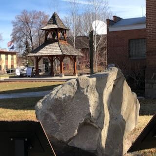
An 8 ton erratic left behind by Glacial Lake Missoula in the Bitterroot Valley on the property of a local rancher was relocated to serve as the focal point of an outdoor kiosk exhibit at the Ravalli County Museum at the former County Courthouse, 205 Bedford Street in Hamilton. Unlike their counterparts at other location along the National Geologic Trail, erratics in this part of the Ice Age Floods did not come from Canada nor did they travel as far, but the action of the floodwaters and iceberg rafts is equally evident despite more shallow waters. There are similar erratics found elsewhere in Bitterroot, on the campus of the University of Montana, and at the Bison Range. The outdoor display tells the same story as other locations on the Ice Age Floods National Geologic Trail but also includes information on two other National Park Service trails that pass through this area – the Nez Perce and the Lewis and Clark National Historic Trails. The museum has other indoor exhibits of historical interest and about Glacial Lake Missoula.
Little Money Creek Gulch Fill
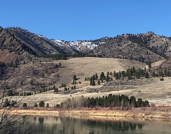
Mounds of soil, sand, gravel, and other coarse materials covered with light vegetation can be seen in the side gulches all along the Flathead River where tributaries drained into what was Glacial Lake Missoula. They were deposited by currents eddying into the slower water in these gulches and also by the drop in velocity of the streams carrying deposits from higher elevations on the far side of the river along the path of the escaping floodwaters. The flow of floodwaters through this narrow valley was estimated by J.T. Pardee at between 8 and 10 cubic miles per hours – more than the combined flow of all modern rivers in the world. Similar gulch fill can be seen in many locations along this beautiful stretch of the river, which today generally flows smoothly and looks completely flat. There are numerous pull-outs along MT 200 between Perma and Paradise; the view pictured here is at mile marker 91.