Puget Sound Area has a Glacial Story to Tell

Although the Seattle region was not impacted by the large floods from Glacial Lake Missoula, Glacial Lake Columbia, or other glacial lakes east of the Cascades, the Puget Sound region has its own glacial story to tell. It’s interesting that J Harlen Bretz, who first imagined that a massive flood produced the Floods features in the Columbia Plateau, also did his PhD on “Glaciation of the Puget Sound Region”. The Puget Lobe of the Cordilleran Ice Sheet advanced and retreated over the Puget Lowland at least seven times during the Quaternary Ice Age. In the process, it left behind rocks, sediments, and other geologic clues that tell the intriguing story of ice, proglacial lakes, and flooding across the landscape near Seattle. Snoqualmie Falls, near North Bend, WA east of Seattle is a popular tourist destination. At the falls, the Snoqualmie River plunges 82m over a wall of volcanic rock. Few tourists, however, understand the role that the Puget Lobe of the Cordilleran Ice Sheet played in the formation of the falls. Prior to glaciation, Snoqualmie Falls did not exist, instead, the river flowed in an incised channel east of the current falls. As the Puget lobe advanced into the Puget Lowland about 18,700 years ago, the glacier’s eastern margin blocked drainage from rivers flowing out of the Cascades, including the Snoqualmie River. A large glacial lake known as Glacial Lake Snoqualmie formed over North Bend and over the Snoqualmie Valley. Tokul Creek, one of the tributaries, formed a thick underwater delta in the lake as its sediments poured into Glacial Lake Snoqualmie. When the Puget Lobe retreated, Glacial Lake Snoqualmie drained to the west and the Snoqualmie river attempted to follow its original channel. However, the original course of the river was blocked by the delta deposits from Tokul Creek and the river was forced to flow over a narrow band of rocks from an eroded volcano further to the south. Snoqualmie Falls flows over this volcanic rock today, but since the last glacial maximum, cataract recession has rapidly eroded the rocks back to a 200m wide band of andesite and volcanic breccia. Behind the thin volcanics is a thick layer of soft alluvium. At the current rate of recession, the Snoqualmie River will erode through the volcanic rock in about 7,200 years. When that happens, the river will hit the alluvium and the falls will quickly devolve into a series of rapids. You might want to hurry to see the falls before they disappear! Other glacial lakes were formed at the southern margin of the Puget Lobe near modern day Seattle. As the Puget Lobe advanced south, it dammed rivers and streams that were flowing north. In places, the bluffs surrounding modern Puget Sound hold a record of the advancing glacier and the pro-glacial lakes backed up by the ice front. One good place to view these sediments is from the beach at Discovery Park in Seattle. A layer cake of sedimentary units records the pre-glacial river system, the advance of the ice, the damming of the proglacial lakes, and the retreat of the ice sheet to the north. At the base of the cliffs the Olympia Formation records the pre-glacial environment of north-flowing rivers and streams. The Lawton Clay layer indicates the formation of proglacial lakes. The Esperance sand represents a period of glacial retreat. The glacier that repeatedly covered the Puget Lowland left behind multiple geologic clues for us to interpret. The Puget Lobe of IAFI welcomes members from other chapters to join us as we explore the glacial history of the Puget Lowland.
White Bluffs at Hanford Reach

Appearing much different than the nearly ubiquitous Columbia River basalt cliffs and boulders of central Washington, the White Bluffs area features a series of 50-170 m tall buff-colored bluffs and badlands underlain by those basalts. These are outcropping layers of the Ringold Formation comprising most of a 600-ft high escarpment exposed along the north and east banks of the Columbia River in south-central Washington. These ancient river and lakebed sediments were laid down by the Columbia and Snake River systems 8.5 to 3.4 million years ago. However, a section of the White Bluffs are a much younger stack of slackwater rhythmite deposits that filled a paleochannel eroded into the Ringold Formation, These late Ice Age rhythmites are only 17,550-12,500 years old. They were laid down as each of the 40 or more Ice Age Floods backed up behind the narrow constriction at Wallula Gap, submerging the entire White Bluffs area under temporary Lake Lewis. Up to about a dozen rhythmites, composed mostly of sand from as many floods, occur within the channel fill. At the top of most rhythmites is a layer of wind-blown sand suggesting a period of dryness separated each flood. Sediment thicknesses and sedimentary structures in each of the beds give a sense of the tremendous sediment load and the relatively calm conditions of the ponded flood waters. Learn more from Nick Zentner’s 2-Minute Geology video – The White Bluffs at Hanford Reach The White Bluffs are located along the east side of the Columbia River, across from the former towns of Hanford and Whitebluffs, on the Hanford Reach National Monument where the atomic age was born. The bluffs have been exposed by the Columbia River down cutting and moving laterally against the deep silts and sands and old soil horizons that make up the bluffs. These towering white bluffs, massive sand dunes, and the last free flowing nontidal section of the Columbia River all help make the Hanford Reach one of the most dramatic natural areas in the state. Take a Hike on the White Bluffs Rhythmites Trail, Lat, Long: 46.642855, -119.403263
Lake Lenore Caves – Lower Grand Coulee
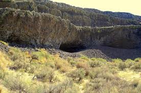
Tucked into the Lenore Canyon are the Lake Lenore Caves. Along with much of the eastern half of the state, Lenore Canyon was formed during the Missoula floods at the end of the last Ice Age, over 13,000 years ago. The glacial flood waters crashed down the canyon, carving through the basalt that makes up the sheer rock walls, creating coulees, ridges, cliffs, plateaus, rock slides, caves and a series of lakes. The caves themselves are shallow, created during the Great Missoula flood as water pulled chunks of basalt from the walls of the coulee. Post-flood weathering created talus slopes that furnished easy access and temporary overnight camps and storage for at least 5,000 years for hunters and gatherers from villages located elsewhere in the Grand Coulee and along the Columbia River and its tributaries. It is still used today for certain Native American religious ceremonies. It is easy to see why the caves were chosen as a cozy place to stay, as the depth provided plenty of shelter from the elements, while not going so deep that light couldn’t reach the back corners. It is often quite warm and breezy outside, but in the caves it is cool and calm. A well-marked 1.2-mile out-and-back trail leads from the parking area to some of the caves. It is generally considered an easy route that takes an average of 31 min to complete. This is a popular trail for hiking and walking, but you can still enjoy some solitude during quieter times of day. The best times to visit this trail are March through November. Dogs are welcome, but must be on a leash. The coulee walls in this area are made up of Grande Ronde Basalt flows overlain by the Frenchman Springs and Roza members of the Wanapum Basalt. The lower (colonnade) and upper (entablature) cooling units of individual flows are visible in the coulee walls. Flow unit contacts are sometimes complex to interpret. Some flows pinch out against older flows, some are perhaps due to flows covering an irregular topographic surface on the underlying flow, some may be filling of shallow valleys, and some multiple layers may be pulses of lava from the fluid interior pushing out over the partially formed entablature of a previous lava pulse.
McBones – Ice Age Floods Mammoth Dig

The Tri-Cities area, home to the Lake Lewis Chapter of IAFI, is inching its way into spring and it’s time to say goodbye to winter. And for some of us, it’s time to begin the 2023 dig season at Coyote Canyon, the resting place of a 17,500-year-old Columbian mammoth. Coyote Canyon is just a few miles southwest of Kennewick in the Horse Heaven Hills. Last month we cleaned up the winter erosion and set up the field equipment so work can begin in earnest in April. Several bones, yet to be identified, were partially exposed last fall and hopes are high for exposing and removing them this summer. This elephant relative was deposited on the west side of Coyote Canyon during one of the earlier Ice Age floods and is buried by possibly six layers of floods sediment. Numerous erratic rocks have been found among the bones. Just before the pandemic temporarily paused work at the site, a local high school girl was assigned the task of identifying rock types of a cluster of small erratics buried near the animal’s left shoulder blade. She then identified outcrops of the same types of rocks in northern Idaho, at or near the ice dam. Finally, she documented her work with a poster and presented it at the 2019 GSA conference in Portland, Oregon. With digging comes tourism. As usual, public tour lists have filled for spring and summer-fall tour reservations will open on June first. To sign up for a tour the public can visit our new website, www.mcbones.weebly.com. School and private group tours are also available. At the time of this writing, we have scheduled six public tours, 30 elementary class tours and 13 group tours, including one for vision impaired and one for non-English speakers. All of our presentations emphasize the importance of the Ice Age floods to the mammoth story at Coyote Canyon.
Grand Coulee – Geology of the Entire 50 miles

The 50-mile-long Grand Coulee should be on everyone’s bucket list for a “must see” feature. The immense power of the forces that created the Coulee are apparent to those who read the evidence recorded in its rocks and landforms. How did the Coulee form? Why did it form here? What do features like Steamboat Rock, Northrup Canyon, Dry Falls, and the Ephrata Fan tell us about the geological forces that created the Grand Coulee? This presentation will be made May 1, 2023 beginning at 7:00 pm, via Zoom _ https://us02web.zoom.us/j/82985244730 Dr Gene Kiver is professor Emeritus of Geology, Eastern Washington University. He studied alpine glaciation in the Rocky Mountains before moving to Washington State and discovering that J Harlen Bretz had correctly interpreted the bizarre landforms of the Channeled Scabland. Gene taught geology at Eastern Washington University for 34 years. He co-authored “On the Trail of Ice Age Floods” with Bruce Bjornstad that describes the flood history of the northern flood routes of the Missoula Floods. In addition, he authored/co-authored the book “Washington Rocks” and several other books. One item in particular is “Tour Guide Interstate 90 East Tour: Seattle to Spokane” (2007). A CD narration of the people and places as defined by the title. Of the 51 tracks, Dr. Kiver narrates 4 on the Geology of I-90. The Chapter webmaster has ordered it and will update this post after listening to the recording. I bring this up as many of our lectures are about or by people who explored or are exploring the geography of the Ice Age Floods. Look on Amazon under “Eugene Kiver” for this and other books.
Camas Prairie Ripples

Camas Prairie Ripples The Camas Prairie Ripples, located 12 miles north of Perma, Montana, appear as prominent ridges 15 to 50 feet high, 100 to 250 feet wide, and from 300 feet to a half-mile long – the largest ripples on earth. While the form, structure and arrangement of these features are similar to that of ordinary current ripple marks, they are termed giant flood ripples, due to their large size. Most ripples that are formed by rivers today are only inches high and are mostly made up of sand-sized particles. Many of the Camas Prairie ripples are composed of boulder-sized geologic debris, and since the size of ripples is related to the strength of a river’s currents, these ripples were created by currents so powerful they are difficult to comprehend. The best examples of giant flood ripples are found in Camas Prairie. The Camas Prairie Ripples were formed by strong currents associated with as many as 40 to 100 emptyings of Glacial Lake Missoula over 4,000 years beginning some 17,000 years ago. Glacial Lake Missoula was formed by a massive lobe of the Pleistocene Cordilleran ice sheet that blocked the mouth of the Clark Fork River at Lake Pend Oreille, Idaho, a result of successive advances of the Cordilleran Ice Sheet during the Ice Age, when mammoths, saber-toothed cats, and giant ground sloths still roamed the landscape. It was the largest of several lakes impounded by the Cordilleran Ice Sheet in the Northern Rocky Mountains during the Quaternary period. The lake that formed behind the ice dam expanded until it was 3,000 square miles, held 500 cubic miles of water, and was 2,000 feet deep – as big as Lakes Erie and Ontario combined. It occupied the Mission, Jocko and Little Bitterroot valleys, drained by the Flathead River; and the Missoula, Ninemile and Bitterroot valleys, drained by the Clark Fork River. When the ice dam eventually collapsed Glacial Lake Missoula emptied catastrophically to the west on across the Columbia Plateau and down the Columbia River Basin, its waters moving at maximum speeds of 80 miles per hour to the Pacific Ocean. The flood waters ran with the force equal to 60 Amazon Rivers and moved car-sized boulders up to 500 miles, embedded in icebergs from the failed ice dam. It occupied the Mission, Jocko and Little Bitterroot valleys, drained by the Flathead River; and the Missoula, Ninemile and Bitterroot valleys, drained by the Clark Fork River. It is estimated that the catastrophic flood waters of Glacial Lake Missoula, 1,000 feet deep at Eddy Narrows, drained at a peak discharge rate of 10 cubic miles per hour. Approximately 380 cubic miles of water passed through those narrows, during withdrawal. Evidence of this catastrophic withdrawal can be found in scourings, high eddy deposits of flood debris, flood bars of boulders and course gravel, and successions of giant arcuate ripples or ridges of gravel resting on bedrock surfaces. The giant flood ripples at this site are unusual due to their being on the down-current side of notches in a ridge separating two basins that were both subsidiary to the main course of Lake Missoula in the Clark Fork Valley. Flathead Land Trust’s largest conservation easement protects 3,867 acres of the Camas Prairie near Hot Springs. The rolling grasslands of the Camaroot Ranch were first homesteaded in 1910, the year the Flathead Indian Reservation was first open to land acquisition. The Cross family’s ownership began in 1920 when Sid Cross’s grandparents, John and Anna Lauraman, first acquired 160 acres. They and other relatives continued to acquire surrounding land over the next several decades. At one time the ranch totaled almost 6,000 acres. Parts of three homesteads still remain on the property including a 2-story house and old barn that was built in the 1920s where Anna Lauraman grew up. The ranch was used for grazing cows and horses, and raising some crops such as alfalfa and wheat. The Cross family sold the property to the Confederated Salish and Kootenai Tribe in 2015. The conservation easement on this unique property preserves open space, agricultural land, and the giant ripples as silent monuments of Montana’s prehistoric and chaotic past. The locale includes a mixture of private, public and landtrust lands throughout the Camas Prairie area.
Bison Range
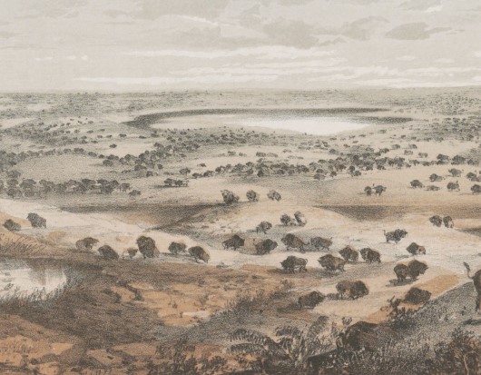
Bison Range The Bison Range was established by President Theodore Roosevelt in 1908 to conserve the American Bison. Since that time it has been managed as a wildlife refuge and native grassland. Today the management is done by the Confederated Salish and Kootenai Tribes. The range is a small, low-rolling mountain connected to the Mission Mountain Range by a gradually descending spur. Range elevation varies from 2,585 feet (788 m) at headquarters to 4,885 feet (1,489 m) at High Point on Red Sleep Mountain, the highest point on the Range. Much of the Bison Range was once under prehistoric Glacial Lake Missoula. The upper part of the Range was above water. Red Sleep Mountain scenic drive leads to this high point, which has spectacular views across what was once the lake to the Mission Mountains on the other side. Other flood features are evident on Buffalo Prairie scenic drive. Old beach lines (strandlines) can be seen on north-facing slopes and some large erratics are located near the old corrals. There is a visitor center near the entrance which has a display and videos of Glacial Lake Missoula as well as information on the tribes of the Flathead Reservation and the abundant wildlife, including birds, bears and antelope. There is also a gift shop. Camas Prairie ripples and several other important features of Glacial Lake Missoula are in close proximity to this site, much of them are located on tribal lands. The entrance is off US 93 and MT 212 N about an hour north of Missoula. Bison Range58355 Bison Range Rd, Moiese, MT (406) 644-2661 bisonrange.org FEES – there is a fee for entrance, including the day use area, except for CSKT tribal members OPEN HOURSWinter Hours (Nov-April)Gate: 8am–6pmVisitors Center: 8am–5pm Red Sleep Drive: closed Buffalo Prairie Drive: 8am-6pm Summer Hours (May-Oct)Gate: 7am–8pmVisitors Center: 8am–7pm Red Sleep Drive: 8am–7pm Buffalo Prairie Drive:8am–8pm Restrictions: Vehicles over 30 feet long and those owing trailers as well as motorcycles, ATVs, and bicycles are not allowed on either drive. Visitors must remain inside vehicles at all times except for designated areas
Chinook Scenic Byway

The Chinook Scenic Byway is recognized as a premier driving tour in Washington State. The byway travels through the Mt. Baker-Snoqualmie National Forest and Mount Rainier National Park. Experience the diverse landscape of the Central Cascades, from Enumclaw and the glacier-fed White River Valley to the west, up and over 5,430′ Chinook Pass, to the fertile valley of Naches to the east.Visitors experiencing the byway can enjoy spectacular views of dense forests, towering peaks, rocky ridges and river canyons dominate this journey. On a clear day the view of Mount Rainier is breathtaking. Pass through basalt flows of the High Cascades and of the Columbia Plateau, old growth forests, lush subalpine meadows, a world-class ski area and numerous streams, lakes and waterfalls. Not only will you find exceptional scenery, but dozens of opportunities for outdoor fun and recreation await. Be sure to download your free copy of the new byway itinerary. The 25-page guide highlights the history, communities, and environment that make this such a unique drive. The new guide features a map and helps making trip planning easy by highlighting where to stay and play. https://www.youtube.com/watch?v=VakH74S6UyI
Ephrata Erratic Fan

EPHRATA ERRATICS FAN Ice Age Floods National Geologic Trail The Ephrata Erratics Fan is a depositional area south of where water from the Missoula floods poured out of the lower Grand Coulee. It is called a fan because the deposit is spread out like a fan or delta. The basalt and granite boulders now littering the Ephrata Fan were carried there by torrents of water that gushed out of the Grand Coulee. Water and debris exploded from the mouth of the Lower Grand Coulee complex sending debris in a wide swath like pellets from the mouth of a shotgun. Velocity reduction at the coulee mouth and debris momentum carried large boulders a mile or more before they began to settle out of the slowing water stream. The largest of these, “Monster Rock”, is estimated to be about 8m (25 feet) in diameter and contains over 500 cubic yards of rock that weighs over 1,500 tons! “The Ephrata fan is an immense accumulation of gravel and sand that resulted when mega-flood waters from Crab Creek, Dry Coulee, the lower Grand Coulee (ending at Soap Lake), and smaller scabland channels entered the Quincy Basin. The deposit probably formed more in the manner of an immense expansion bar (Baker, 1973a), rather than a fluvial fan in which relatively small alluvial channels shift across the fan surface without ever inundating the entire surface at once. Local areas of surface scour occurred on the fan, the most prominent of which is Rocky Ford Creek. The scour probably developed during waning flood stages, when draining of the inundated Quincy Basin caused relatively steep water-surface gradients to occur over the depositional surfaces that had been constructional during the high stages of megaflooding (Baker, 1973a). The scour processes produced the lag concentration of boulders on the fan surface, many of which can be seen from this viewpoint. An alternative explanation for the morphology of the Ephrata fan is that it was progressively incised by a sequence of multiple floods of successively decreasing magnitudes (Waitt, 1994; Waitt et al., 2009). It may also be that a more complex combination of these mechanisms occurred.” Due to sudden expansion, the floodwaters decelerated and deposited about 130 feet of sediment onto the fan. At the head of the bar, east of Ephrata, are house-size boulders up to 60 feet in diameter. Sediment sizes in the fan decrease with distance south from the mouth of the Grand Coulee. Many of the large boulders that cover the fan are basalt that was likely ripped out of Grand Coulee and other scabland channels just upstream. There are also numerous granitic erratics that were likely carried in the floods from as far away as the Grand Coulee Dam area, over 6o miles north. Quick Facts Location:Hwy 17 south of Ephrata, WA at Hatchery Rd NE. OPEN TO PUBLIC:No MANAGED BY:Private Owner
The Paradise Center

The Paradise Center Ice Age Floods National Geologic Trail Paradise Center, formerly the Paradise Elementary School, is a community, visitors, and arts center in the old railroad community of the same name. Just below the confluence of the muddy Clark Fork and beautiful blue Flathead Rivers, 70 miles northwest of Missoula, the area was repeatedly inundated by Glacial Lake Missoula, leaving many visible features in the area such as gulch fills, kolks, and lake bottom sediment bluffs. It is on the route between the Camas Prairie Ripples and Eddy Narrows. Inside the school is a unique interactive 3-D topographical or relief map of the entire area covered by Glacial Lake Missoula and an extensive display of information about the Lake as well as other topics of interest to the area. Outside on the grounds is a playground and an outdoor walking loop with a dozen or so displays of interest such as the former railroad roundhouse. A model railroad set-up is also found inside the center. This area can easily be reached directly from the St. Regis exit from I-90 by following the Clark Fork River where flood waters turned sharply to the north, carving out the narrow valley along scenic route 135 to the junction with MT-200. Scour marks and displaced boulders are visible from the road, and it is especially lovely when the larch trees turn bright yellow in the fall. This route also takes you past the historic Quinn’s Hot Springs Resort. ANNOUNCEMENT: The Paradise Center hours are seasonal, generally Wednesday thru Saturday, 11am-3pm in the summer. Check the website at paradisecentermt.org or call 406-826-0500 Quick Facts Location:2 School House Hill Road Paradise, MT 59856 MANAGED BY:The Paradise Center