The Bowl & Pitcher at Riverside State Park
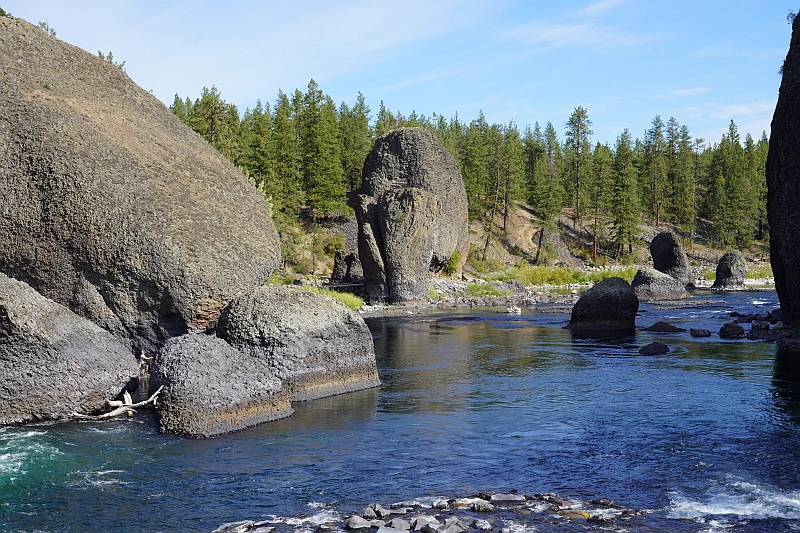
The Bowl and Pitcher is a rock formation along the Spokane River and one of the most scenic sites in the area, with basalt cliffs rising 500 feet above the river and large blocks of basalt in the river causing large rapids. The “Bowl” is a circular depression in the river and the “Pitcher” is a large detached block of highly fractured basalt. The geology of Spokane’s Bowl and Picher features dramatic basalt cliffs carved out of the flows from the Columbia River Basalt Group (CRBG), which reached this area 16 million years ago. There are river and flood deposits of sand and gravel, with granitic boulders forming terraces on the east side of the river, and huge blocks of basalt, causing the Dragon Tooth rapids, downriver from the Bowl and Pitcher. How did those rocks get there? The Spokane and Columbia rivers occupy a long, mostly bedrock canyon near the northeastern boundary of the Columbia Plateau. Glacial Lake Columbia, which formed behind the Okanogan ice lobe, occupied all of the Spokane River and a portion of the Columbia drainage basin during the last Ice Age. Then the glacial Lake Missoula outburst floods first surged over the Columbia Basin beginning around 17,000 years ago, ripping away the CRBG and other bedrock from Bayview, Idaho, to the Pacific Ocean. These floods also deposited a thick sequence of flood gravel in the valley. As Lake Columbia water level dropped, the Spokane River began to remove the sand and gravel fill. Subsequent floods continued to remove the flood deposits, leaving the basalt benches on the west side of the river and the terraces on the east side. Riverside State Park is located northwest of Spokane and consists of over 9000 acres along the Spokane and Little Spokane Rivers. The park is the second largest state park and has many recreational activities including, camping, hiking, mountain biking, horseback riding and boating (Discover Pass required). There are two view points for the Bowl and Pitcher. The first is from a small parking lot off the entrance road from Aubry White Parkway that provides an elevated view of the site. The main parking area is down along the river with a picnic area and a network of trails. From the parking lot you can follow the wheelchair accessible path across the suspension bridge over the Spokane River. From the bridge you can enjoy a view of the features that give the site its name. The original bridge was built in 1942 by the Civilian Conservation Corps. The existing bridge, based on the same plans, opened in 1998. On the west side of the river, you can access a network of trails along the river or climb up along the bluffs above the river.
Kititas Valley Historical Museum – Ellensburg
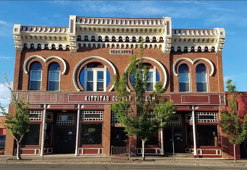
IN THE CITY OF ELLENSBURG… when you want to spend some time indoors, a great place to visit is the KITTITAS VALLEY HISTORICAL MUSEUM. It has about 30,000 items from which more than 50 exhibits and displays are chosen. The mission of the museum is to, “Collect, Preserve and Share the History, Heritage, and Culture of Kittitas County.” In experiencing it you feel a strong connection to the Pacific Northwest. Collection highlights include: Indigenous cultural items (especially from the K’tɨ́taas and Pshwánapam bands). Note the roots here for the local names of Kittitas and Wanapum. Geological specimens, including Ellensburg Blue Agate Some fossilized animals Household goods, textiles, and furnishings Military memorabilia and service records Historic photographs and albums Agricultural tools and equipment Business records and local commerce material Even the building itself is interesting. Built of brick, it was constructed after the Great Ellensburg Fire of July 4, 1889. (There is an exhibit about that fire and its devastation to the town). Some examples of what you will see: So, if you are so inclined, spend some time and enjoy. The museum is open Monday through Saturday from 10am to 4pm. The address is 114 E. 3rd Ave. Ellensburg Admission is free and donations are accepted. Article by Mike Doran: President of the Ellensburg Chapter of the Ice Age Floods Institute
Glacial erratics of the Puget Lowland
Strewn among the forests of the Puget Lowland are an impressive array of Glacial Erratics. Although technically erratics include small pebbles and even sand grains in till, people tend to get the most excited by really big erratics- those the size of a house or building. Whatever their size, glacial erratics often reveal the direction of the ice flow that ripped them from their source region and deposited them at their resting place. Erratics can also help determine the thickness of the ice sheet that deposited them. In the Seattle area, it is relatively straightforward to determine the provenance of erratics containing quartzite, as that rock can not be found anywhere in the Olympics, the Cascades, or in the native bedrock of the Puget Lowland. Quartzite, which is durable and resistant to weathering, is commonly found in river valleys of central British Columbia and in the glacial tills of the Puget Lowland. However, granodiorite erratics found in the lowland and on the slopes of the Olympics and Cascades can be more difficult to decipher. The granodiorite in these erratics is chemically similar to rock bodies both in the British Columbia Coast Mountains and in the Cascades. In the mountains east of Bellingham, erratics found at 5,000 ft of elevation imply that the thickness of the Puget Lobe of the Cordilleran Ice sheet was at least 5,000 ft thick at that location. Maps showing the thickness of the Cordilleran Ice Sheet at various places in Western Washington are drawn, in part, by looking at the depositional altitude of erratics on ridges around the region. The two most massive erratics in the Puget Lowland are composed of Greenschist metamorphic rock. One of the giant erratics of Western Washington hides in the forest in Saratoga Woods Park on Whidbey Island. The Waterman erratic is 38ft high and has a circumference of 135 ft. Analysis of the rock shows that it is composed of Greenschist, a rock containing the low grade metamorphic minerals Chlorite and Epidote. The Greenschist chemically matches the rock of Mt. Erie, a prominent Roche Moutonée found 40 miles to the north on Fidalgo Island. An even larger erratic can be seen in a suburban neighborhood near Everett. The Lake Stevens erratic, 34 ft tall with a circumference of 210 ft, is considered the largest erratic in the Northwest, and possibly the largest erratic in the United States. This erratic is also composed of a Greenschist, although chemical analysis cannot give us a definitive origin for the big rock. There is similar Greenschist on the northern tip of Whidbey Island at Deception Pass, around Mt. Shuksan in the North Cascades, and also up the Fraser River in British Columbia. Article by Dale Lehman
Moses Coulee: An Ice Age Enigma

Washington state is famous for its dramatic landscapes, many carved by the immense power of the Ice Age Floods. We know the stories of the Grand Coulee, Palouse Canyon, and the Potholes. But tucked away in north-central Washington, cutting a path from northeast to southwest across the Okanagan Plateau, lies Moses Coulee – perhaps the most mysterious of them all. Unlike its famous cousins, Moses Coulee doesn’t quite fit the standard narrative. Its head seemingly emerges from beneath the Wisconsin Withrow Moraine, and its very formation presents a fascinating puzzle for geologists. Flood Theories and Questions: An Enigma The Grand Coulees (Upper and Lower) are widely believed to have been carved by the spectacular Missoula Floods. These colossal deluges were unleashed when the Okanagan Lobe of the Cordilleran Ice Sheet blocked the Columbia River, redirecting massive amounts of water southward. For Moses Coulee, it’s not so clear-cut. While cataract retreat due to massive floodwaters is generally assumed, most theories suggest the Okanagan Lobe effectively blocked the Missoula Floods from entering Moses Coulee. So, what carved this impressive landscape? Enter J. Harlan Bretz, the pioneering geologist who first championed the idea of colossal floods shaping the Pacific Northwest. Bretz observed a distinct wide bench within Moses Coulee, high above its floor. This led him to speculate about two distinct periods of glacial floods: An older, pre-Wisconsin “Spokane Flood” that initially carved Moses Coulee. A later Wisconsin period flood (what we now call the Missoula Floods) that deepened the coulee floor. Interestingly, current speculation suggests the Upper Grand Coulee might also owe its primary formation to these earlier “Spokane Floods,” with the Lower Grand Coulee being a product of the later Missoula Floods. It seems the story of Washington’s coulees is far more layered than once thought! Beyond Glacial Lakes: A Subglacial Hypothesis But wait, there’s another fascinating idea. Some investigators propose that Moses Coulee wasn’t carved by the well-known Missoula or Columbia glacial lake outbursts at all. Instead, they suggest outbreak floods from under the ice sheet itself. Joel Gombiner and Jerome Lesemann have explored this idea, suggesting that the immense pressure of the overlying ice lobe could have forced subglacial meltwater to flow uphill over topographic highs. This water would then have exited from under the ice, becoming the powerful floodwaters that sculpted Moses Coulee. Imagine that — floods erupting from beneath a massive glacier! Explore the Mystery Yourself The interplay between the Withrow Moraine and the unique features of Moses Coulee makes this a truly captivating area for exploration, especially for those intrigued by the raw power of ancient ice and water. To truly enhance your visit to this less-traveled gem, we highly recommend: Watching several of Nick Zentner’s insightful videos where he dives deep into these Moses Coulee questions. His engaging explanations bring the geology to life! Examining J. Harlan Bretz’s original field notes, meticulously organized in geolocated Google Maps by Glenn Cruickshank. It’s like stepping back in time with the pioneering geologist himself. Moses Coulee is more than just a landscape; it’s an ongoing geological debate etched into the earth. Are you ready to explore this remarkable natural mystery? AI-assisted article by Lloyd DeKay – Columbia River Gorge Chapter
Palouse Falls State Park

Palouse Falls State Park, dedicated in 1951, is a 94-acre park showcasing the dramatic Palouse Falls and its unique geological history. The park is a popular destination for viewing the falls, which were formed by Ice Age floods and are a key part of the Ice Age Floods National Geological Trail. The falls were designated as Washington’s state official waterfall in 2014, thanks to the advocacy of schoolchildren from Washtucna. Palouse Falls is one of four of the last remaining year-round waterfalls on the Palouse River that once stood in the path of the ice age floods. It is rich in both geological and human history. The native Palouse Indians called it “Aput Aput” meaning “falling water.” They believed that it was created by the Great Spirit because of his displeasure with the wicked Indians who lived further upstream. This obstacle was a barrier that allowed the salmon to travel no further. Sam Fisher, a Palouse Indian, also tells the story of how four giant brothers and their giant sister used oil from beaver tails to keep their hair shiny. Needing more oil, they searched for the giant beaver and fought with him. All four falls on the river were made when the beaver slapped his tail. At the last battle at Palouse Falls, the beaver struck his tail one last time creating the falls and the bowl it falls into. The vertical cracks in the basalt were made by the claws of the beaver. Palouse Falls has made a powerful impression on all who have visited. For example, one of the fall’s earliest visitors, Laurence L. Dodd in 1867, described the site he saw this way: “just before descending the Snake River hill your eye rests on the grateful green bottom of the Palouse with its clear and pure waters, flowing into the turbid Snake and after ascending the Snake River hill to the northward and eastward, the eye sweeps over a vast extent of country rarely surpassed in rugged desolation and wildness.…” Dodd was accompanied by a few local citizens from Starbuck on horseback to witness the scene he described. Early access to the falls was either by train (many passenger trains would stop here for their passengers to look at the falls) or by coming in from the east side. Robert E. Strahorn, who built the railroad up the Palouse Canyon had the original idea of making Palouse Falls a State Park. But it was not until years later that Washtucna area resident and president of the Washtucna Community Service Club John H. Baumann really pushed the idea. In 1945, Palouse Falls State Park was created. It was dedicated on June 3rd, 1951. The 299 acres that make up the entirety of this vast park were donated by The Baker-Boyer National Bank of Walla Walla, J.M. McGregor of the McGregor Land and Livestock Company of Hooper, and Mrs. Agnes Sells, a resident of Washtucna. Palouse Falls State Park is located off Highway 261, which branches off Highway 260 out of Washtucna. The most popular season for visiting is in the spring when the river is at its highest from winter snow melt. However, each season has its own story to tell as these pictures show. Article by Lloyd Stoess, President IAFI Palouse Falls Chapter
Whispers from a Frozen Past: “We Have The Bones” – McBones Mammoth Dig

We know the story…a world gripped by ice. Some twenty thousand years ago, colossal glaciers sculpted the landscape, their icy fingers reaching down through the Idaho panhandle. They choked the ancient Clark Fork River, birthing a vast, temporary lake: Glacial Lake Missoula. Then, the inevitable happened. The icy dam buckled, unleashing unimaginable torrents of water that carved a dramatic path across the land in a series of cataclysmic floods. We see their scars today – stark strand lines etched into hillsides, the labyrinthine coulees, silent dry waterfalls, and the scattered, out-of-place “erratic” rocks, silent witnesses to a watery fury. But beyond the sheer power of these floods, a more profound question lingers: What life thrived in the shadow of this impending devastation? What world existed downstream of Glacial Lake Missoula in the fleeting calm before each deluge? The answer, astonishingly, is life. Vibrant and resilient, creatures roamed the landscape, unaware of the watery apocalypse that would soon reshape their world. And now, buried within the very sediments left by those colossal floods, echoes of this Ice Age existence are being unearthed. Just south of the Tri-Cities in Washington, a remarkable discovery is unfolding. Here, the bones of a 17,500-year-old Columbian mammoth are being meticulously excavated, offering a breathtaking glimpse into a time when ice dominated the north. Imagine this majestic creature, striding across a landscape soon to be ravaged by floodwaters, its final resting place a testament to the sheer scale of these geological events. Now a 17,500-year-old Columbian mammoth is being excavated just south of the Tri-Cities in Washington and visitors can tour the site. For many, a visit to this active dig site is within easy reach – a captivating day trip, a memorable overnight stay, or a fascinating detour along the Ice Age Floods National Geologic Trail. Stand on the very ground where this ancient giant lay buried, a staggering seven hundred feet above the present-day Columbia River, entombed in soil deposited by the very floods that shaped this region. The incredible work of unearthing these secrets is led by the dedicated nonprofit organization, MCBONES. At the Coyote Canyon Mammoth Site, they offer a unique opportunity to step back in time. For a modest $10 per person (sign up at www.mcbones.org), from April until mid-October the public can join guided tours of this active paleontological dig. Witness firsthand the careful process of uncovering these ancient relics and hear the compelling story of this mammoth’s burial, the clues it offers about the pre-flood environment, and the ongoing discoveries that are rewriting our understanding of this dramatic period. Every dollar from tour admissions, gift shop sales, and generous donations directly fuels this vital research, ensuring that these whispers from a frozen past continue to be heard.
Discovering the Telford Tract: A Hidden Gem in the Channeled Scablands

Traveling east along Lake Roosevelt from the Grand Coulee brings you closer to an area steeped in geological and historical intrigue. This journey not only unveils the legacy of ancient Glacial Lake Columbia but also leads to one of the most captivating sections of the Channeled Scablands: the Telford Tract. A critical player in the narrative of Ice Age floods, the Telford Tract offers a striking example of the power and scope of these ancient cataclysmic events. The Role of Glacial Lake Columbia The current Lake Roosevelt occupies much of the previous western Glacial Lake Columbia area, a massive lake formed when glacial ice blocked the Columbia River’s southwestward flow. The lake’s height and timing had a dramatic influence on the routes taken by the incoming Glacial Lake Missoula floodwaters. A portion of these immense floods, among the largest known in Earth’s history, surged south through the Telford region, carving canyons, depositing sediments, and shaping the land into what we now call the Channeled Scablands. J Harlen Bretz, the geologist who first described the scablands in detail, outlined these pathways or “tracts” in his seminal 1928 paper, The Channeled Scabland of Eastern Washington. Among the four major scabland tracts Bretz identified, the Telford-Crab Creek Tract is particularly significant for its geological features and historical context: “The Telford-Crab Creek scabland tract…heads in the vicinity of Telford station…as wide as the Cheney-Palouse River tract…convergence of all these (and of all but one of the Cheney-Palouse River divergences) occurs in a wide shallow structural sag (Quincy Basin) in the western part of the plateau. In this basin is the largest single area of gravel left by the glacial waters…There is continuous scabland northward from all channel heads of this tract across the plateau divide to the limits reached by the ice sheet.” Exploring the Telford Tract Today The Telford Tract, adjacent to the Lake Roosevelt National Recreation Area, provides an unparalleled opportunity to witness the scars of Ice Age floods. Once a 900-acre homestead, the tract’s eroded flood channels and gravel deposits serve as a testament to the massive forces that shaped this region. Managed by the Bureau of Land Management, the Telford Recreation Area invites visitors to explore this geological marvel. Hiking trails weave through remnants of these ancient waterways, offering a chance to immerse yourself in one of the major routes of the Missoula Floodwaters. Check out these resources to help plan your visit: BLM Telford Recreation Area and Washington Trails Association: Telford Recreation Area Beyond Telford: Exploring Upper Crab Creek For those looking to expand their journey through this region, the Telford Tract’s channels eventually connect to Crab Creek, another iconic feature shaped by glacial waters. The Upper Crab Creek Field Trip offers a deeper dive into this fascinating landscape, combining geological exploration with breathtaking scenery. In 2013 Karl Lillquist and Jack Powell created an Upper Crab Creek Field Trip guide for the Ellensburg Chapter of the Ice Age Floods Institute. A Landscape Worth Protecting The Telford Tract exemplifies the dynamic history of the Channeled Scablands and the profound environmental changes brought about by Ice Age floods. As part of the Ice Age Floods National Geologic Trail, this area’s preservation ensures that future generations can continue to learn from and appreciate its unique geological story. Whether you are a geology enthusiast, history buff, or outdoor adventurer, the Telford Tract promises an unforgettable experience. This landscape, shaped by forces beyond imagination, stands as a humbling reminder of nature’s power and its enduring impact on the Earth’s surface.
Explore Lake Roosevelt National Recreation Area
The Lake Roosevelt National Recreation Area serves as a striking landmark that narrates a dramatic geological history shaped by colossal natural forces. Greatly influenced by the Missoula Floods, this area, part of the Ice Age Floods National Geologic Trail, reveals not only stunning landscapes but also insights into the Earth’s geological story. Understanding this region offers a glimpse into the powerful events that occurred between 13,500 and 18,500 years ago, as well as the enduring environmental significance of these features. Lake Roosevelt and Grand Coulee Dam Lake Roosevelt, created by the Grand Coulee Dam in the 1930s, serves multiple purposes: from water storage and hydroelectric power generation to recreation and wildlife preservation. The lake provides a crucial habitat for various species and supports a vibrant ecosystem and is home to a range of fish species, including walleye, rainbow trout, and Kokanee salmon. The surrounding lands offer habitats for birds and other wildlife, contributing to ecological balance. With over 400 miles of scenic shoreline, the 150 mile long goes from Grand Coulee nearly to the Canadian board and is a haven for outdoor enthusiasts. The lake offers expansive waters perfect for various forms of boating. Anglers can enjoy abundant fishing opportunities year-round. 32 different campgrounds such as Spring Canyon close to Grand Coulee, WA offer numerous places to extend your overnight stays with these stunning landscapes. Historical Heritage The Lake Roosevelt area holds historical significance for the Confederated Tribes of the Colville Reservation and the Spokane Tribe of Indians, highlighting the intertwined relationship between Native heritage and the natural landscape. The National Park Service (NPS) supports Bureau of Reclamation management of Bakes Lake, Coulee Dam, and Lake Roosevelt. NPS works with Washington State Parks throughout the Grand Coulee Corridor and along with the Tribes and Washington Department of Natural Resources, oversees recreation on the water and lands of Lake Roosevelt NRA. Our collective efforts work to ensure that these natural treasures are preserved for future generations. Visitors to the area can engage with a variety of programs and informational resources that enhance their understanding and respect for the environment. Power in Nature The Grand Coulee and Lake Roosevelt National Recreation Area stand as remarkable examples of nature’s power and the intricate tapestry of geological history. From the cataclysmic Missoula Floods that sculpted the landscape to the thriving ecosystems supported by Lake Roosevelt, this region offers an unparalleled opportunity for exploration and discovery. Whether you are an avid hiker, a passionate angler, or a curious geology enthusiast, this area provides not only recreational activities but also a deeper connection to the Earth’s history. As we delve into the breathtaking scenery and rich cultural heritage of this national recreation area, we are reminded of the dynamic forces that shape our world. The Grand Coulee and Lake Roosevelt invite each visitor to engage with the past while understanding the importance of stewardship for future generations. This stunning landscape not only captivates the eye; it expands our knowledge of nature and our place within Ice Age Floods National Geologic Trail.
Coyote Canyon Mammoth Dig
The Coyote Canyon Mammoth Dig is an active paleontological excavation site in the Horse Heaven Hills near Kennewick, Washington. It’s a significant project that sheds light on the history of the Ice Age floods in the Tri-Cities area. The dig focuses on the unearthed remains of a Columbian mammoth that lived approximately 17,500 years ago. The mammoth’s carcass was buried in Touchet beds, a geological formation laid down by ancient floods. The site sits at an elevation of 1040 feet above sea level, which is considerably higher than the current elevation of the Columbia River, which is only 350 feet above sea level about 7 miles north. Scientists estimate that Lake Lewis, a massive glacial lake that existed during the Ice Age, reached a maximum surface elevation of over 1200 feet above sea level at the time the mammoth perished. This substantial difference in elevation hints at the immense power of the Ice Age floods that swept across the region. Another fascinating aspect of the Coyote Canyon Mammoth Dig is the discovery of a vast pile of erratic rocks. Initially thought to be a small cluster, the collection of these displaced rocks has grown to extend into several adjacent dig units. A dig unit, for those unfamiliar with archaeological and paleontological fieldwork, is a standardized square measuring 2 meters by 2 meters that archaeologists and paleontologists use to meticulously excavate and collect data. The MCBones Research Center, a non-profit organization, spearheads the Coyote Canyon Mammoth Dig. They offer educational tours for schools and other groups, providing a firsthand look at this significant paleontological excavation. These tours are a great opportunity to learn more about the Ice Age floods, mammoths, and the meticulous work of paleontologists. For more information about the Coyote Canyon Mammoth Dig, including details about tours, visit the MCBones Research Center website at www.mcbones.org.
Bitterroot Valley Glacial Erratics
Two glacial erratics in the Bitterroot Valley, the Lone Rock School erratic and the Rome Lane erratic, were deposited during the last high stand of Lake Missoula about 13,000 years ago. Both these glacial erratics are easy to visit. At the extreme Southern end of the Bitterroot Valley is beautiful Lake Como named after its Italian alpine counter part by Father Ravalli a Jesuit Black Robe tasked with bringing literacy and Jesus to the native Salish people in 1845 via St Mary’s Mission in nearby Stevensville. Lake Como is a beautiful place for lunch and a hike/bike on the trail around lake including a beautiful waterfall a the head of the lake. Several mountain glaciers coalesced here and neighboring drainage to make the largest mass of ice calving into the lake south of the Flathead lobe of the Cordilleran ice sheet at Polson. This mass exited the mountains, floated into and calved into Glacial Lake Missoula. This was the primary iceberg generator for the Bitterroot Valley. As they floated out into the lake and melted they dropped large rocks called erratic onto the lake floor, which is now the surface of the valley. Lone Rock School Erratic The easiest one to find is the Lone Rock School erratic. From Stevensville, proceed north on the Eastside Highway, county road 269, to the junction with county road 268, turn right. Follow county road 268 until you reach the Lone Rock School on your left; the erratic is the large boulder in front of the south side of the school, and behind the fence (see map below). The Lone Rock School erratic is 69” tall, 58” wide, 85” long, and weighs in at about 8.5 metric tons or about 18,700 lbs. This large erratic is a type of granite called quartz monzonite. The minerals that make up this rock type are, in order of abundance, plagioclase (calcium and/or sodium rich) feldspar, orthoclase (potassium rich) feldspar, biotite (dark mica), and quartz. If you look closely you will see that the quartz typically stands out in relief with respect to the other minerals and that its surface has been polished to a smooth finish. This is the result of dense glacial ice grinding over the surface of the rock. Rome Lane Erratic The Rome Lane erratic measures 47” tall, 117” long, 96” wide, and weighs in at about 13 metric tons or about 28,600 lbs. The Rome Lane erratic is almost identical to the Lone Rock School erratic; it to is quartz monzonite granite with approximately the same minerals and mineral proportions. The observation that both erratics are of similar rock type suggests that they came from a similar source region. There are sources of quartz monzonite granite in both the Sapphire and Bitterroot Mountains, which is the source of these erratics? Since we know that the erratics were carried to the shores of glacial Lake Missoula by glaciers, we can rule out the Sapphires as a possible source because we know that no glaciers in the Sapphire Mountains ever reached the shores of Lake Missoula. So, the erratics had to come from the Bitterroot Mountains where the quartz monzonite granite lies anywhere between 5 and 20 miles from the ancient shoreline of Lake Missoula. That means glaciers carried the erratics for distances of up to 20 miles (32.2 km) before reaching the shores of glacial Lake Missoula. Which at an average velocity of 5 meters per day (normal for most valley glaciers with the exception of rare bursts in velocity up to 75 meters per day) would take about 18 years. Which Erratic is Oldest? The quartz grains on the surfaces of the Rome Lane erratic are polished to a smooth shine and stand out in relief above the other minerals, similar to the Lone Rock School erratic. However, the quartz grains exposed on the top surface of the Rome Lane erratic seem to exhibit higher relief than the quartz grains exposed on any other side of the Rome Lane erratic and/or the top surface of the Lone Rock School erratic. Why is this? Rainwater is slightly acidic and acidic fluids can break down some minerals, such as feldspar, and turn them into clay. Quartz, however, is very resistant to acidic fluids and as a result takes longer to break down or weather. It is this difference in weathering rates between feldspar and quartz that causes the quartz grains to stand higher than the feldspar grains. So, based on this relationship we can say that the greater the relief between quartz and feldspar on a rock surface, the longer that surface has been exposed to the elements i.e. rain and wind. With that in mind, which erratic’s top surface has been exposed longer? If you answered Lone Rock, you are correct. As it turns out the Lone Rock School erratic was dug up and moved from its original location, about ¾ of a mile to the south of where it sits today, to commemorate the Lone Rock Schools’ centennial in 1985, in fact upon its excavation portions of the erratic broke off and remain buried. So what is the top surface of the Lone Rock School erratic today may well not have been the top surface before 1985, and our mineral weathering hypothesis fits the facts.