Hells Canyon Caves Reveal When it was Cut

The origin story of Hells Canyon, North America’s deepest river gorge, has long been unclear to scientists. But new research estimates it formed about 2.1 million years ago when a dramatic flood event likely created a river over the deep gorge. The researchers made the finding after studying clues hidden in the landscape and river deposits preserved in caves. They described their findings in a study published May 19 in the journal PNAS>. Hells Canyon borders Oregon, Idaho and Washington. It’s cut through by the Snake River and is North America’s deepest river gorge, at 10 miles (16 kilometers) wide and about 1.5 miles (2.4 km) deep — almost 2,000 feet deeper than the Grand Canyon. Canyons are inherently difficult to understand and date, said study lead author Matthew Morriss, a geologist at the Utah Geological Survey. “As a river erodes and carves a canyon, it sort of destroys the evidence of its own history,” Morriss told Live Science. But because Hells Canyon is so steep, he guessed it was carved quickly. To find out how the gorge formed, the team examined caves along the side of the canyon. When floods cause rivers to swell, they can deposit sediment into caves where it’s then preserved, Morriss said. The researchers analyzed gravel deposited by the Snake River in three caves along the sides of Hells Canyon, and estimated the age of the deposited material using isotope dating. This enabled the researchers to determine when the river was higher than its current level, which would have been when it was shaping the canyon. The team combined this information with the locations of knickpoints — drastic changes in river steepness where the rivers connect to the gorge — to piece together Hells Canyon’s history. These clues suggest that Hells Canyon formed when water diverted from Lake Idaho into the current route of the gorge to form what’s now the Snake River. The lake may have spilled over because of higher precipitation, or changes to the continental divide, Morriss said. This caused a river to form a path over the area that’s now Hells Canyon, and the water slowly began eroding rock about 5 million years ago, then carved the gorge much more quickly from about 2.1 million years ago. The canyon’s age was unexpected. “The age of the canyon was so much younger than I thought it would be,” Morriss said. “I had no idea it could be as young as 2 million years old — that’s younger than the Grand Canyon, which most people think could be about 5 million years old.” Hells Canyon has a lot in common with the Grand Canyon, according to Karl Karlstrom, geologist at the University of New Mexico whose work focuses on the Grand Canyon, and who was not involved with the new research. “The Grand Canyon and Hells Canyon always get compared to each other,” said Karlstrom. “They’re both big canyons with big rivers at the bottom, they’re about the same length and the same width,” Karlstrom told Live Science, but this study gives a clear picture of Hells Canyon’s distinct history. “To me this paper is a good hypothesis, and it paves the way for next generations of work,” Karlstrom said. Dating more caves in the canyon, and integrating other dating methodologies, could refine the findings and make the dates more precise, Karlstrom added. The findings can inform research on other canyons that may have been carved quickly by rivers, Morriss said. Understanding the history of Hells Canyon also gives insight into how the canyon’s formation shaped the surrounding ecosystem, as some animal species are divided by the canyon and others connected across it. Many landscape features of the southwestern U.S., like Hells Canyon and the Grand Canyon, are younger than previously expected. “[The] Western U.S. has a young and ever changing landscape that has been reshaped in the past few million years and is currently still adjusting,” Karlstrom said. This shows just how quickly — on the scale of geological time — a landscape can dramatically change, he noted. LiveScience article by Olivia Ferrari
Anthropoclastite – Rock Formed in 35 Years or Less

New research reveals industrial waste can turn into rock in as little as 35 years, instead of the thousands or millions of years previously assumed. The finding challenges what scientists know about rock formation, revealing an entirely new “anthropoclastic rock cycle.” The scientists found that waste from seaside industrial plants turns into rock especially rapidly due to the ocean water and air, which activate minerals such as calcium and magnesium in the waste, or slag, cementing it together faster than natural sediments. For a couple of hundred years, we’ve understood the rock cycle as a natural process that takes thousands to millions of years but these human-made materials are being incorporated into natural systems and becoming lithified — essentially turning into rock — over the course of decades instead. Researchers dubbed this newly discovered process the “rapid anthropoclastic rock cycle.” The findings challenge long-standing theories about how rocks form and suggest industries have far less time to dispose of their waste properly than previously thought, Owen said in the statement. The research was published April 10 in the journal Geology. Researchers discovered the first clues of turbo slag-to-rock transformation on Derwent Howe, a giant pile of waste from now-closed iron and steelmaking plants on the northwest coast of England. The scientists noticed irregular formations in these slag “cliffs,” prompting them to take a closer look. One sample contained an aluminum can tab, with a design that couldn’t have been manufactured before 1989, embedded in the material that helped the researchers estimate how long it takes for slag to lithify. For the can tab to become encased in rock, the slag must have solidified and lithified in the past 35 years. It’s possible that these processes finished earlier, so 35 years is the maximum time it takes to turn slag into rock. Scientists have previously made similar observations on the coast of Spain in the Gorrondatxe area, the researchers noted in the study, but those observations didn’t come with a time frame. Excerpted from a LiveScience article by Sascha Pare
The Earth – A Brief Overview
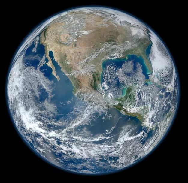
Background The 4.5 billion-year-old Earth is the only known astronomical object to harbor life, giving rise to billions of species of stunning diversity, including ours, Homo sapiens. It has formed the backdrop of an estimated 110 billion human lives. At 13.1 septillion pounds and 25,000 miles in circumference, the third planet from the sun long formed the horizon of all human experience and knowledge (watch overview). Recent discoveries have revealed our home planet’s relative size and location in the universe: a pale blue dot within the Orion Spur, located 26,000 light-years from the center of the Milky Way Galaxy, one of 100,000 galaxies within the Laniakea Supercluster. Formation Early Earth is theorized to have formed alongside the other planets within a solar nebula, where a massive cloud of spinning, interstellar gas and dust contracted under its own gravity and flattened into a hot disk (watch visualization). The core of the disk became dense with lighter elements like hydrogen, eventually heating up and triggering nuclear fusion, forming the sun. Solar wind pushed lighter elements farther out into the system, while heavier metals like iron gathered into increasingly larger masses known as planetismals in a process called accretion to form the Earth and other inner rocky planets. As the protoplanet grew, heat from the colliding material and radioactive decay differentiated Earth’s heavier iron-rich core from its lighter rocky mantle, giving rise to Earth’s magnetic field and long-term stability. Various models suggest Earth’s formation took tens of millions of years. Two billion years later, Earth changed dramatically when cyanobacteria, a microbe, evolved to generate energy from sunlight (i.e., photosynthesis) and release oxygen as a byproduct into the atmosphere during the Great Oxidation Event. Structure and Composition Earth is the densest planet in the solar system and the most massive of the four rocky terrestrials. Shaped into a sphere by gravity, Earth is flattened at its poles and bulges at its equator due to its roughly 1,000-mile-per-hour eastward spin (Jupiter spins 28 times faster). By analyzing seismic waves, researchers theorize that a solid, 9,800-degree Fahrenheit inner core is surrounded by an outer core of liquid iron and nickel—common elements that consolidate into solids at high pressures. Above the core, a slow-moving rocky mantle moves the crust’s tectonic plates, causing volcanoes and earthquakes (see overview). Earth’s spin combines with the core’s electrical conductivity and extreme heat to produce a magnetic field that protects its surface from damaging solar winds, cosmic rays, and deep space radiation. This so-called geodynamo process is expected to last for billions of years. Surface and Climate Situated within the solar system’s “Goldilocks zone,” Earth is the only planet with conditions able to sustain liquid surface water, key to the formation of life. Roughly 71% of its surface is water; the rest is land. An estimated 300 million planets in our galaxy are located in similar zones. The Earth’s five-layer atmosphere traps solar energy and maintains an average global surface temperature of 59 degrees Fahrenheit. Roughly 21% is oxygen, crucial for respiration but highly flammable. Nitrogen (78%) dilutes the oxygen and prevents rapid combustion. Seasons result from the Earth’s 23.4-degree tilt in relation to the orbital plane. Ice ages last millions of years and result from shifting climatic conditions—like ocean currents and the position of tectonic plates—that drop average temperatures by double digits. We live amid the fifth major ice age, though we are in the middle of a warmer interglacial period that began 11,000 years ago.
Tectonic Plate Subduction Contagion?

Evidence from Earth’s deep past suggests dramatic subduction zones can spread like a contagion. Subduction zones, where one tectonic plate dives underneath another, drive the world’s most devastating earthquakes and tsunamis. How do these danger zones come to be? A study in Geology presents evidence that subduction can spread like a contagion, jumping from one oceanic plate to another — a hypothesis previously difficult to prove. Because subduction drags crust deep into the earth, its beginnings are hard to examine. The new study provides a rare ancient example of potential subduction “infection.” Its authors say they’ve discovered evidence that neighboring collisions triggered East Asia’s “Ring of Fire,” a colossal subduction system currently fueling earthquakes and volcanoes from Alaska to the southern Indian Ocean. Nearly 300 million years ago Asia was a scattering of islands separated by the ancient Tethys and Asian oceans. Established subduction zones consumed these oceans, welding the landmasses into a new continent and raising mountains from Turkey to China. By 260 million years ago this subduction seems to have spread and begun pulling down the neighboring Pacific plate. “The dying act of those closing oceans may have been to infect the Pacific plate and start it subducting westward under the Asian continent,” says study lead author Mark Allen, a geologist at Durham University in England. “In one form or another, it’s been diving down ever since.” But the mechanism of spread remains mysterious. The researchers suspect that transform faults — boundaries where plates slide past one another, like the San Andreas Fault — may act as weak spots where slight changes in collision angle or speed can destabilize dense oceanic crust, causing it to sink. Duarte compares the scenario to aluminum foil in water. “The foil floats,” he says, “but the slightest tap will cause it to sink.” If subduction spreads this way, could the Atlantic Ocean‘s relatively quiet plate margins be next? The massive 1755 Lisbon earthquake hints at early subduction invasion there. Duarte suggests parts of Iberia and the Caribbean are undergoing this process’s initial stages: “In another 100 million years a new Atlantic ‘Ring of Fire’ may form — just as it once did in the Pacific.” Excerpted from a Live Science article by Evan Howell
Yellowstone Supervolcano’s “Breathing” Cap Offers Eruption Insights
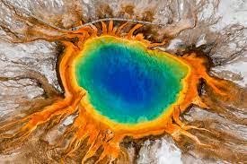
Scientists have discovered a “breathing” magma cap beneath the Yellowstone supervolcano, offering new clues about its eruption potential. This layer, located about 2.6 miles below the surface, acts like a lid on the magma reservoir. While this cap traps significant heat and pressure, it’s not completely sealed. Researchers found it to be porous, allowing for a gradual release of pressure. This natural venting mechanism may explain why Yellowstone hasn’t experienced a major eruption in hundreds of thousands of years. Using seismic waves the team mapped the upper boundary of the magma system. Their analysis indicates the cap consists of molten minerals and supercritical water bubbles within porous rock. Instead of building up to a critical point, the bubbles appear to be escaping through the cap’s pores, preventing a dangerous pressure surge. Professor Brandon Schmandt of Rice University compares this to “steady breathing,” noting that the volatile content is below levels typically preceding an eruption. The efficient venting of gas through cracks in the cap aligns with Yellowstone’s numerous hydrothermal features that release magmatic gases. This discovery provides a clearer picture of Yellowstone’s magma system and suggests that the risk of an imminent massive eruption might be lower than previously considered. The “breathing” cap offers a valuable insight into the volcano’s dynamics and highlights the ongoing processes that shape this remarkable geological wonder.
Our Pale Blue Dot
Background The 4.5 billion-year-old Earth is the only known astronomical object to harbor life, giving rise to billions of species of stunning diversity, including ours, Homo sapiens. It has formed the backdrop of an estimated 110 billion human lives. At 13.1 septillion pounds and 25,000 miles in circumference, the third planet from the sun long formed the horizon of all human experience and knowledge (watch overview). Recent discoveries have revealed our home planet’s relative size and location in the universe: a pale blue dot within the Orion Spur, located 26,000 light-years from the center of the Milky Way Galaxy, one of 100,000 galaxies within the Laniakea Supercluster. Formation Early Earth is theorized to have formed alongside the other planets within a solar nebula, where a massive cloud of spinning, interstellar gas and dust contracted under its own gravity and flattened into a hot disk (watch visualization). The core of the disk became dense with lighter elements like hydrogen, eventually heating up and triggering nuclear fusion, forming the sun. Solar wind pushed lighter elements farther out into the system, while heavier metals like iron gathered into increasingly larger masses known as planetesimals in a process called accretion to form the Earth and other inner rocky planets. As the protoplanet grew, heat from the colliding material and radioactive decay differentiated Earth’s heavier iron-rich core from its lighter rocky mantle, giving rise to Earth’s magnetic field and long-term stability. Various models suggest Earth’s formation took tens of millions of years. Two billion years later, Earth changed dramatically when cyanobacteria, a microbe, evolved to generate energy from sunlight (i.e., photosynthesis) and release oxygen as a byproduct into the atmosphere during the Great Oxidation Event. Structure and Composition Earth is the densest planet in the solar system and the most massive of the four rocky terrestrials. Shaped into a sphere by gravity, Earth is flattened at its poles and bulges at its equator due to its roughly 1,000-mile-per-hour eastward spin (Jupiter spins 28 times faster). By analyzing seismic waves, researchers theorize that a solid, 9,800-degree Fahrenheit inner core is surrounded by an outer core of liquid iron and nickel—common elements that consolidate into solids at high pressures. Above the core, a slow-moving rocky mantle moves the crust’s tectonic plates, causing volcanoes and earthquakes (see overview). Earth’s spin combines with the core’s electrical conductivity and extreme heat to produce a magnetic field that protects its surface from damaging solar winds, cosmic rays, and deep space radiation. This so-called geodynamo process is expected to last for billions of years. Surface and Climate Situated within the solar system’s “Goldilocks zone,” Earth is the only planet with conditions able to sustain liquid surface water, key to the formation of life. Roughly 71% of its surface is water; the rest is land. An estimated 300 million planets in our galaxy are located in similar zones. The Earth’s five-layer atmosphere traps solar energy and maintains an average global surface temperature of 59 degrees Fahrenheit. Roughly 21% is oxygen, crucial for respiration but highly flammable. Nitrogen (78%) dilutes the oxygen and prevents rapid combustion. Seasons result from the Earth’s 23.4-degree tilt in relation to the orbital plane. Ice ages last millions of years and result from shifting climatic conditions—like ocean currents and the position of tectonic plates—that drop average temperatures by double digits. We live amid the fifth major ice age, though we are in the middle of a warmer interglacial period that began 11,000 years ago. Reprinted from 1440 Daily Digest
Melanie Bell Gibbs – Valuable Cheney-Spokane Chapter Volunteer
What would you say about a volunteer who has spent literally years advancing the mission of the Ice Age Floods Institute and still continues to do so, even in semi-retirement? You would have to say she is the prime example of the committed, capable, enthusiastic, and gifted volunteer every organization would like to have. When she moved to the Spokane area from Northeast Texas, a proud Texan became a determined and energetic citizen for the state of Washington–and eventually a valuable member of the Ice Age Floods Institute. She became a member of the Ice Age Floods Institute and Cheney-Spokane Chapter as early as 2005. Over the years she was active: Serving as Secretary, Treasurer, President of the Cheney-Spokane Chapter and currently serves as Past President. Recruiting Sponsors and Partners. Writing grants and was successful in funding production of brochures, booklets, flyers and providing for event exhibiting supplies. Partnering with Spokane Parks and Recreation to ensure the accuracy of the Ice Age Floods story in the Ice Age Floods Playground that opened in Riverfront Park in May 2021. Helping Science Coordinators understand the importance of Floods curriculum for Spokane School District. Assisting chapters organize the logistics of hosting conferences. Becoming a Lifetime Honorary Chapter Board Member in 2023. In January 2007, she became involved with the Ice Age Floods Institute’s Board of Directors when she was elected to the Board and became the Secretary. Over the years she: Developed Board Calendars, Board Directories, and Annual Meeting Planning Masters. Served as Treasurer. Implemented new Membership Management system. Continues on the Executive Committee and is Chair of the Revenue Generating Committee. Everyone who knows her agrees she is the quintessential volunteer and we are fortunate to have her.
Volunteer Profile – Sue Billings
How would you like to have on your team a volunteer who embodies the following qualities: Enthusiasm – Support – Upbeat Attitude – Availability to help – Creative Ideas – Encouragement The Ellensburg chapter has such a member in Sue Billings. She has been involved in several meetings and projects over the last years. And she is almost always available to help out when called upon. She and her husband, Tom Ring, live in the town of Selah—reflecting the wide spread area from which our members come. And she is able to do all this in addition to having a rich lifestyle in which they travel and stay involved in other projects. Thanks so much for your involvement and contributions, Sue. We really appreciate it. Mike Doran, President Ellensburg Chapter Ice Age Floods Institute
30 Years of IAFI’s Vision Helped Shape the Ice Age Floods National Geologic Trail
This year marks the 30th anniversary of the Ice Age Floods Institute (IAFI), a milestone that offers an opportunity to reflect on the Institute’s foundational role in bringing the story of the Ice Age floods to national prominence and in establishing the Ice Age Floods National Geologic Trail. Founded in 1995, IAFI emerged from a collective recognition of the need to educate the public about the cataclysmic floods that shaped the landscapes of Montana, Idaho, Washington, and Oregon. Through persistent advocacy, community engagement, and educational initiatives, IAFI laid the groundwork for what would become the nation’s first National Geologic Trail. The culmination of these efforts was the passage of Public Law 111-11 in 2009, which officially designated the Ice Age Floods National Geologic Trail. This achievement was the result of a bipartisan effort, with key support from U.S. Senator Maria Cantwell (D-WA) and U.S. Representative Doc Hastings (R-WA), who were primary sponsors of the trail legislation. Other notable supporters included Senators Ron Wyden (D-OR), Larry Craig (R-ID), Patty Murray (D-WA), and Gordon Smith (R-OR). Their collective commitment underscored the shared value placed on preserving and interpreting this significant geologic history. A celebratory ribbon-cutting event was held on May 27, 2009, just after Congress passed the legislation. U.S. Senator Maria Cantwell and U.S. Representative Doc Hastings were joined by Gary Kleinknecht, then-president of the Ice Age Floods Institute. The ribbon-cutting symbolized more than legislative success—it celebrated years of behind-the-scenes advocacy by IAFI leaders and members who worked tirelessly with elected officials to see the trail officially recognized. Since the trail’s designation, the partnership between IAFI and the National Park Service has been integral to the development and interpretation of the Ice Age Floods National Geologic Trail. Collaborative projects have included the creation of interpretive materials, the planning of educational programs, and the development of enhanced digital maps and content to guide visitors through the trail’s extensive network. These joint efforts have been essential in bringing the story of the Ice Age floods to a broader audience. Looking Ahead: Shared Leadership and Future Potential As the Ice Age Floods National Geologic Trail continues to develop, the professional relationship between the Trail’s current National Park Service program manager. Justin Radford, and IAFI’s president, Dr. Gary Ford, exemplifies a strong and effective partnership. Built on mutual respect and a shared commitment to public education and stewardship, our collaboration helps ensure that strategic goals are aligned, innovative educational resources are developed, and public engagement with the Ice Age Floods story continues to grow. This cooperative leadership reflects the enduring values that brought the Trail into existence and remains essential to its continued success. Plans are underway for expanded educational outreach and increased community engagement initiatives. These endeavors aim to deepen public understanding and appreciation of the Ice Age floods’ impact on the region’s geography, while strengthening the relationships that support the Trail’s future. As we celebrate IAFI’s 30-year milestone, we extend our deepest gratitude to IAFI’s members, volunteers, and supporters. Your dedication has been instrumental in transforming a vision into a tangible trail that educates and inspires countless visitors. Together, we look forward to continuing this journey of discovery and interpretation for years to come By Justin Radford, National Park Service – Ice Age Floods National Geologic Trail Program Manager
Discover A Landscape Carved by Ancient Mega-Floods at Fish Lake Regional Park
Just a short drive east of Cheney, Washington, lies Fish Lake Regional Park, a beautiful 76-acre space offering more than just typical park amenities. This area, easily accessible with parking, play areas, hiking trails, and a swimming beach, tells a dramatic story of a landscape shaped by immense Ice Age floods. You’ll find a paved parking lot at the northeast edge of the park, right by the Fish Lake trailhead. From here, you can hop onto the Columbia Plateau State Park Trail and start your adventure! What makes Fish Lake truly unique is its geology. It’s a double plunge pool, a fascinating feature created by powerful, swirling currents during these ancient mega-floods. These paired, counter-rotating currents scoured out the lake basins, and during periods of low water, you can even spot a partial rock ridge, or rock blade, that divides the two pools. An even larger basalt rock blade separates Fish Lake from the nearby Minnie Creek rock channel and a wide, swampy area it drains into. The significance of Fish Lake isn’t lost on those who study these incredible floods. The local chapter of the Ice Age Floods Institute (IAFI), now the Cheney-Spokane Chapter, has been exploring and educating about this area since 2004. Early field trips introduced members to the flood-formed features around Cheney and the Palouse region, with Fish Lake being a key example. Remarkably, even the pioneers of Ice Age Floods research, Joseph Pardee and J Harlen Bretz, visited the Fish Lake area over a century ago, recognizing the powerful forces at play. For those interested in learning more, a video explaining the formation of these scour lakes is available on the IAFI website under the Cheney-Spokane chapter. Geologically, Fish Lake sits on a fascinating junction. It was carved into a chemically weathered contact zone between very old metamorphic rock, dating back a staggering 1.47 billion years, and much younger basalt flows from the Columbia River Basalt Group, around 16 million years old. The lake’s eastward drainage into the Minnie Rock channel further illustrates the powerful erosive forces of the floods. Evidence even suggests the floodwaters in this area reached incredible heights, exceeding 2600 feet, as seen in a small scour lake near Prosser Hill. So, next time you’re looking for a park with natural beauty and a captivating history, consider visiting Fish Lake Regional Park. It’s a place where you can relax and play while standing in a landscape sculpted by one of Earth’s most dramatic events. Condensed from an article by Dr. Linda McCollum, President, Cheney-Spokane Chapter