Drone Footage Of Icelandic Lava River
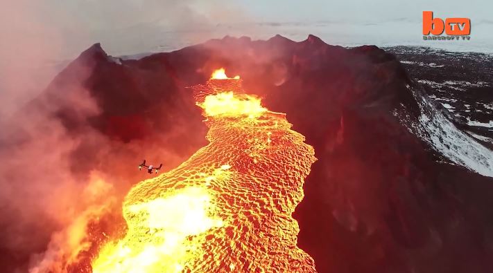
Lake Of Fire: Drone Footage Of Icelandic Lava River 1:46 mins A drone camera flies over a red hot lava lake in freezing cold Iceland and nearly melts in the process. The everchanging rivers of glowing lava shining through the gap between floating pieces of cooled crust are mesmerizing. The stunning footage was captured by US videographer Eric Cheng in February, 2015 and shows smoke and fire burning off the black marbled lava. Videographer / Director: Eric Cheng Producer: Mark Hodge, Chloe Browne Editor: Kyle Waters
IAFI Gorge(ous) Night Out in Salem & Olympia
Columbia Gorge Chapter of IAFI has joined the party It’s easy to see what makes the Gorge a spectacular experience to visitors, but what makes it special to those who live here, work here, and raise our families here? What parts do we play in the larger economic and political fabrics of the states and nation we’re part of? One Gorge (a young Gorge advocacy group) is trying to share who we are and why we matter at the state and national levels, and to promote the big infrastructure factors to help the Gorge community excel. To help our states of Oregon and Washington to better understand and recognize the who, what, and why of interests in the Gorge, One Gorge has worked with Gorge legislators to organize a 2nd annual Gorge(ous) Night Out for Oregon legislators in Salem, and a first-time event with Washington legislators in Olympia. These casual events bring a selection local businesses and organizations sharing products and information together with legislators just to make them more aware of the vibrancy of the Gorge. We’re bringing Columbia Gorge(ous) Geology and the Ice Age Floods to these parties. Two new 40″ x 60″ displays were finished in time for the Salem event on Feb. 3rd and they were extremely popular. Some suggested we were second in popularity only to Insitu UAVs, but we were also located immediately adjacent to the food table, so factor that into the popularity poll. Now everything is ready and tested for the Olympia event on Feb. 9th for Washington legislators, and we’re hoping to build some support there for the Ice Age Floods National Geologic Trail that is focused to a large extent on Washington. Although the main purpose of the Ice Age Floods Institute usually appears to be for education, outreach, and research, it is important to realize that we also have a strong advocacy role to play. When you support the Institute you are also a player in all our education, outreach, research, and advocacy efforts. Thanks to all for your support.
Nova – Mystery of the Mega Flood
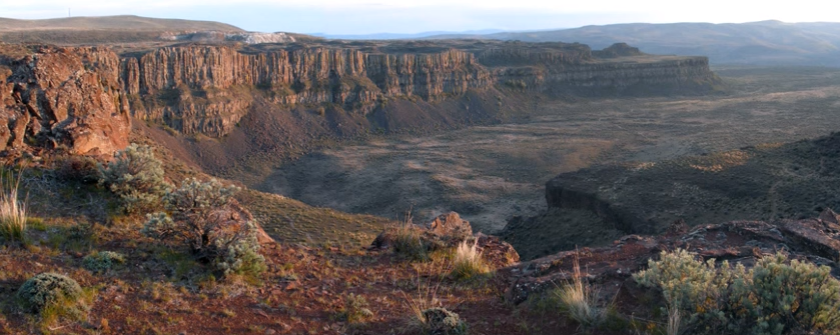
Monument Valley, the Grand Canyon, Niagara Falls: these ancient wonders show how nature’s forces have shaped the face of our planet on a vast timescale, how great landmarks are the work of millions of years of slow, imperceptible erosion by wind and water. But here, across 16,000 square miles of Washington State, abrupt rips and scars in the landscape defy this explanation. What could have formed these tall canyons and immense dry waterfalls? What could have gouged out these gigantic potholes? Whatever happened, the forces unleashed here created one of the Earth’s most enigmatic landscapes. For more than a century, scientists have been grappling with this geological mystery, descending through thousands of years of Earth’s history in a struggle to uncover, layer by layer, how this landscape was formed. Now the clues point to a sequence of events culminating in a massive natural catastrophe. Explore the features and reasoning that lead to the recognition of the “Missoula (Outburst) Floods” and helped to solve “The Mystery of the Megaflood (Spokane Floods or the Bretz Floods)”
Ice Age Floods’ Features
This is an amazing compilation of extra ordinary photographs that have been expertly labeled to assist the viewer’s understanding of the evidence supporting the creation of the Channelled Scablands in Eastern Washington State, USA. The photographs are panned and zoomed in and out on providing an overview and close-ups of flood evidence. Music playing in the background helps the viewer focus on the information displayed in an unhurried manner. The viewer can stop the screen at any time to give them more time to study the information displayed in great clarity. For teaching, this methodology is suburb! Much better than a regular film or static photos. YouTube slideshow prepared by Bruce Bjornstad, published Dec 8, 2012
Floodscapes Map
The map below shows a growing collection of locations and information about Ice Age Floodscapes (landscapes affected by the Ice Age Floods). Use Ctrl+Scroll to zoom, click-hold to drag the map around, click on markers for details, photos, and links to more information. For an index of sites click the the Expand Index icon (arrow in box icon on the black top bar, left side) or View Larger Map icon (box shaped icon on the black top bar, right side) Though we try to maintain accuracy, the Ice Age Floods Institute does not guarantee the accuracy of any information represented on this map. This map is provided solely as an educational service to our members and guests. Floodscape Articles
Missoula Flood Rhythmites
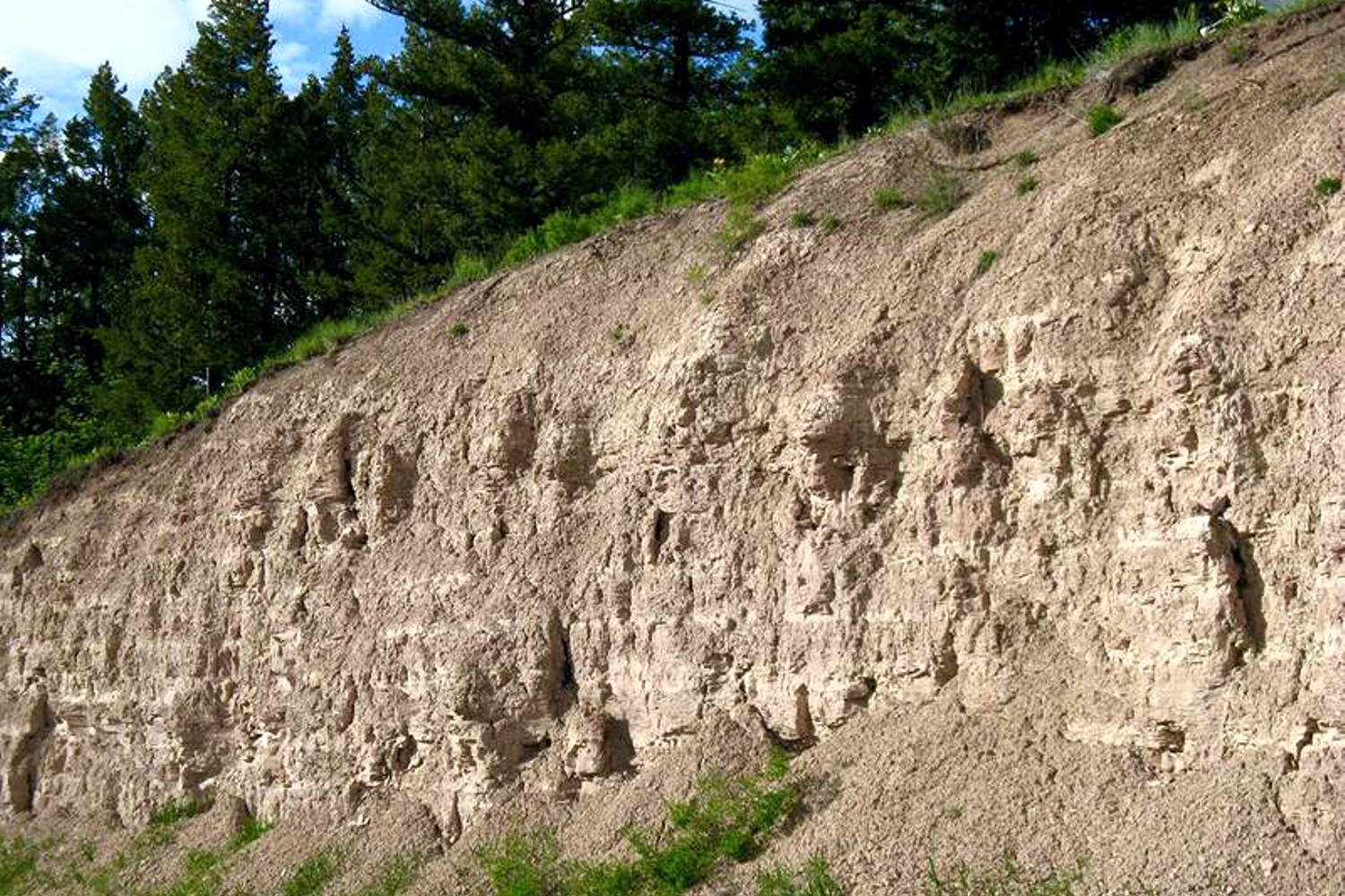
Lake Missoula filled many times and emptied catastrophically in many Missoula Floods. Rhythmite sequences [a series of repeated beds of similar origin] at numerous localities provide this evidence: slack-water rhythmites in backflooded tributary valleys below the dam indicate multiple floods, and varved rhythmites in Lake Missoula attest to multiple fillings of the lake. Below the dam, most slack-water rhythmites are graded beds deposited by flood bores surging up tributary streams. They grade upward from coarse sand and gravel to silt, with occasional ice-rafted erratics. The tops of some rhythmites are marked by thin paleosols, or buried soil horizons, which indicate a period of subaerial exposure. Thus, each rhythmite represents a separate flood event, and each deposit records multiple floods. The most complete record occurs at Sanpoil Valley, an embayment on the north side of Lake Columbia, where varved rhythmites document 89 flood events, with the period of time between floods initially increasing to a maximum of about 50 years and then decreasing to less than 10 years. Thousands of varves were deposited in Lake Missoula. At the best-known Ninemile locality near Missoula, about 40 rhythmites consist of varves overlain by a sand/silt layer. The varves were deposited on the floor of Lake Missoula, and the sand/silt layers represent subaerial exposure and deposition in a stream. The number of varves in each rhythmite varies from 9 to 40, decreasing regularly upward, and the total number of varves is just less than one thousand. An interpretation of these data would suggest: [1] Lake Missoula filled and emptied [in a catastrophic flood] about 40 times, [2] it took 9 to 40 years to fill the lake, each successive lake requiring less time, and [3] the process was repeated over a period of about one thousand years. Because Ninemile is about in the middle of the very long lake, the record here would not provide a complete history of the lake. Correlating Ninemile with the downstream record would suggest these events were in the latter half of the entire flood history.
Glacial Lake Missoula
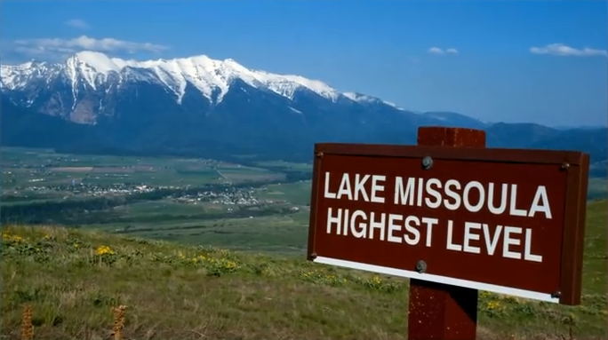
This feature-filled video by Tom Foster and Nick Zentner explores the evidence for Glacial Lake Missoula, and provides a treasure trove of places to visit and sights to see when you plan your field trip to the area.
Ice Age Flood Simulation Video
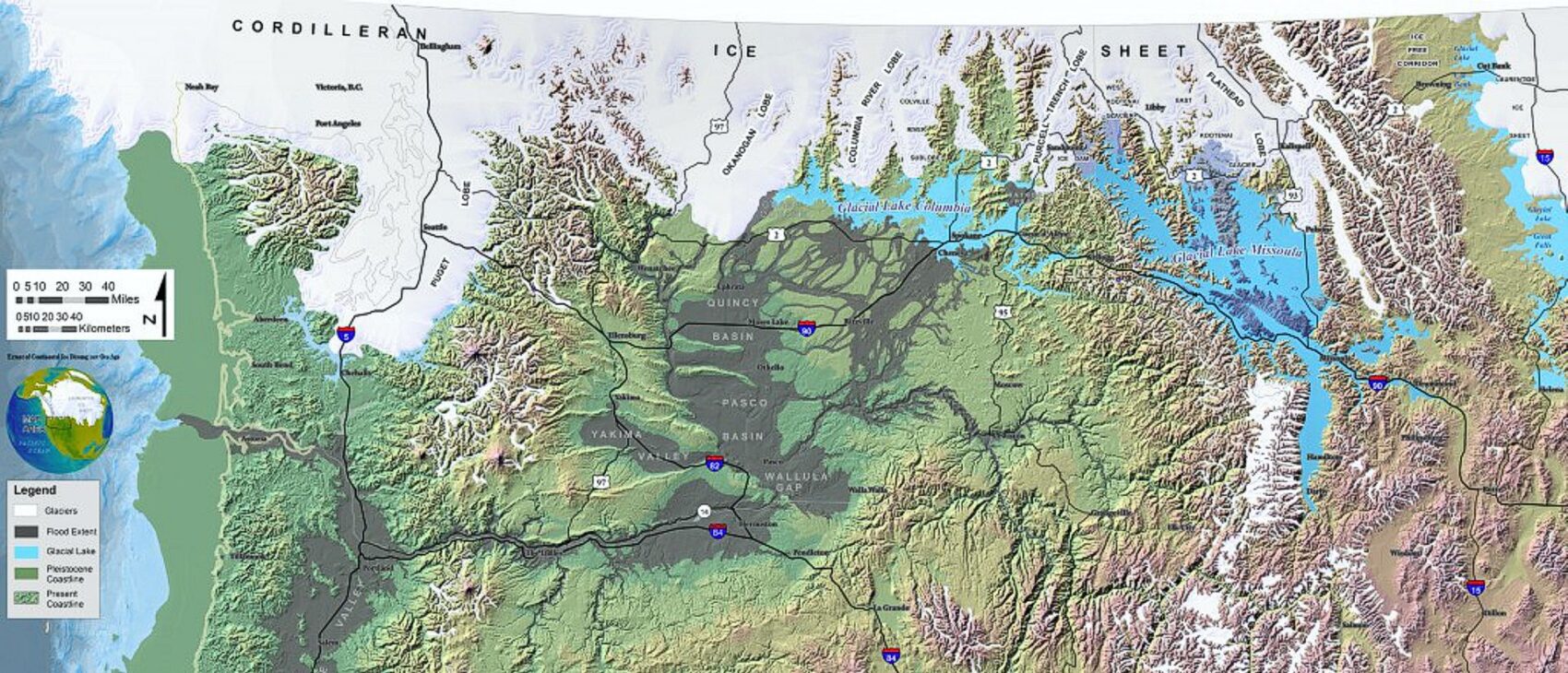
An interesting, 4 minute captioned video from UC Santa Cruz (ingomar200) of a satellite-view computer simulation illustrating flood paths and transient lakes of an Ice Age Flood. The video shows a physics-based computer simulation of the Great Flood from Glacial Lake Missoula about 15,000 years ago. At the time, an ice dam blocked the Clark Fork River near the Idaho-Montana border and backed up a lake about equal in volume to Lake Huron. When the ice dam broke a cataclysmic flood scoured much of central Washington State leaving a vast region covered with erosional remnants.