The Day the Dinosaurs Died
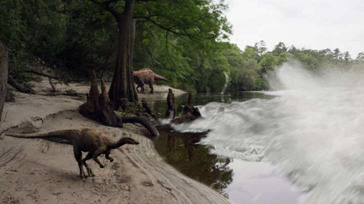
RETROPOLIS – Dave Kindy, Washington Post, May 9, 2022 Discoveries shed new light on the day the dinosaurs died The Thescelosaurus moved stealthily along the seashore. Stretching about 12 feet long and weighing about 500 pounds, the thickly muscled dinosaur was probably looking for food — or trying to avoid becoming a meal. Featuring prominent bony eyebrows and a pointy beak, Thescelosaurus plodded along on two feet with the bulk of its body leaning forward while a long tail stretched backward for balance. Suddenly, the dinosaur lifted its head and looked around, alarmed as the calm was broken by a series of unnerving natural forces. The ground started shaking with intense vibrations while water in the nearby sea sloshed about in response. The sky filled with burning embers, which drifted down and set fire to the lush primordial forest. Thescelosaurus panicked and looked to flee — but it was too late. Everything changed in a heartbeat as a 30-foot-high wave of mud and debris came racing up the seaway from the south, sweeping away life and limb in the process. The dinosaur was caught in the destructive deluge, its leg ripped off at the hip by the devastating surge. That moment — 66 million years ago at the end of the Cretaceous period, when an earth-shattering asteroid ended the reign of the dinosaurs — is frozen in time today through a stunning fossil found last year at the Tanis dig site in North Dakota. This perfectly preserved leg clearly shows the skin, muscle and bones of the three-toed Thescelosaurus. While the details of the death scenario described above are embellished, they’re based on remarkable new findings and accounts by Robert DePalma, lead paleontologist at Tanis. “We’re never going to say with 100 percent certainty that this leg came from an animal that died on that day,” the scientist said. “The thing we can do is determine the likelihood that it died the day the meteor struck. When we look at the preservation of the leg and the skin around the articulated bones, we’re talking on the day of impact or right before. There was no advanced decay.” DePalma and the dinosaur leg will be featured in two episodes of “Nova” on PBS airing back-to-back on Wednesday: “Dinosaur Apocalypse: The New Evidence” and “Dinosaur Apocalypse: The Last Day.” Biologist and natural historian Sir David Attenborough will host the programs, which were produced in conjunction with the BBC. The leg and several other relics discovered at the North Dakota site are the first actual fossils found showing the death and destruction that took place when a 10-mile-long space rock struck the Yucatán Peninsula in the Gulf of Mexico. This impact event 66 million years ago doomed the dinosaurs and led to the mass extinction of 75 percent of animal and plant life on Earth. At the time, the world was a much warmer place. There were no icecaps, and water levels were higher. The North American continent was split in two by the Western Interior Seaway. Tanis is located on what was the edge of that massive river, which became a conduit of carnage after the asteroid struck. The shock waves from nearly 3,000 miles away caused the seaway to erupt with a tsunami of epic proportions. As DePalma pointed out, Thescelosaurus never stood a chance. “You would not want to be there on that day,” he said. “There was a turbulent wall of death heading up the river. In addition, all these glowing spherules are falling out of the sky. They’re like beads of superheated glass reentering the Earth’s atmosphere after being ejected from the crater site at the Yucatán. Then there was all this seismic shaking. It was really hell on earth.” A dinosaur’s loss, though, is a paleontologist’s gain. After Tanis was discovered in 2008, scientists began to realize the fossils there were probably created during that big-impact moment. A series of key discoveries were made, including the dinosaur leg, the embryo of a pterosaur still in its shell, a turtle pierced by a chunk of wood and the well-preserved skin of a triceratops. Many of these fossils are being presented to the public for the first time in the PBS documentaries. Perhaps most telling were the fossilized fish unearthed at the site in 2019, which caught many scientists by surprise. In those petrified remains, researchers found the embedded evidence they needed to substantiate the claim that the animals died when the asteroid struck: the glass spheres, known as ejecta, that came raining down from the sky that fateful day. “Those were fish that died on that day,” DePalma said. “We know that because they had ejecta from the impact in their gills.” Researchers have unearthed countless samples of these glass spheres, all containing the signature chemical components typical of a major impact event. Made up of sand and other earthly materials, the molten glass was ejected into the atmosphere by the explosion caused by the asteroid striking the planet — estimated to be the equivalent of 10 billion atomic bombs. Inside one of those circular fossils is a tiny speck of rock that may be from the killer asteroid itself. DePalma, a postgraduate researcher at the University of Manchester in England and adjunct professor of geosciences at Florida Atlantic University, has headed efforts at Tanis since 2012. He and other scientists on the team have published several major papers describing the discoveries and outlining the scientific methodology used to date the fossils and other evidence. DePalma asserts that what happened then is directly relevant to the world today. “I’ve been asked, ‘Why should we care about this? Dinosaurs have been dead for so long,’ ” he said. “It’s not just for paleo nerds. This directly applies to today. We’re seeing mass die-offs of animals and biomes that are being put through very stressful situations worldwide. By looking through this window into the past, we can apply these lessons to today.” To produce the “Nova” episodes, DePalma worked directly with
Relive Important Archive Articles

A large number of important articles get buried over time as new articles are added to our website, so here’s a chance to review and relive some of our most important articles. We think you might enjoy reviewing these timeless features.
Hydraulic Modeling of a Missoula Flood
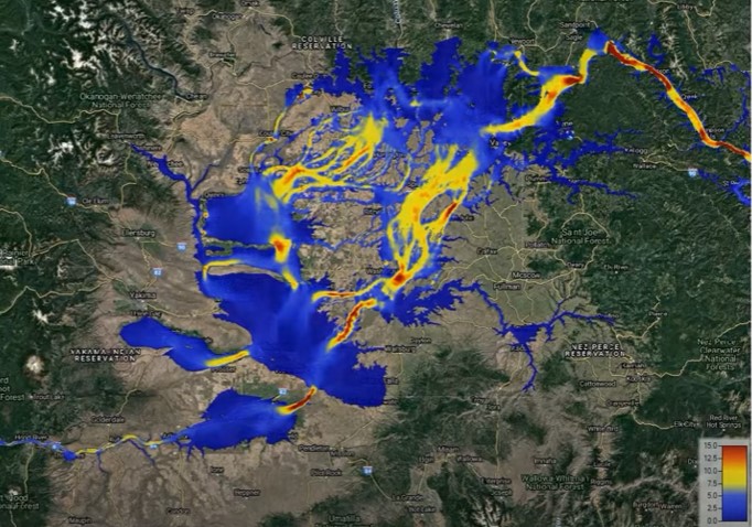
Chris Goodell’s 1-hour video presentation of his Ice Age Flood hydraulic modeling is both enlightening and thought provoking. Chris is a hydraulic modeling professional for Kleinschmidt Group, whose personal interest in the Ice Age Floods phenomenon led him to privately undertake HEC-RAS modeling of a possible Ice Age Flood hydraulic response. His presentation for American Society of Civil Engineers – Environmental & Water Resources Institute – Seattle (ASCE EWRI Seattle) provides interesting insights to the Floods Story even as it recognizes many of the obstacles and shortcomings of what we can know about details of any Ice Age Floods.
Smithsonian Article about the Ice Age Floods
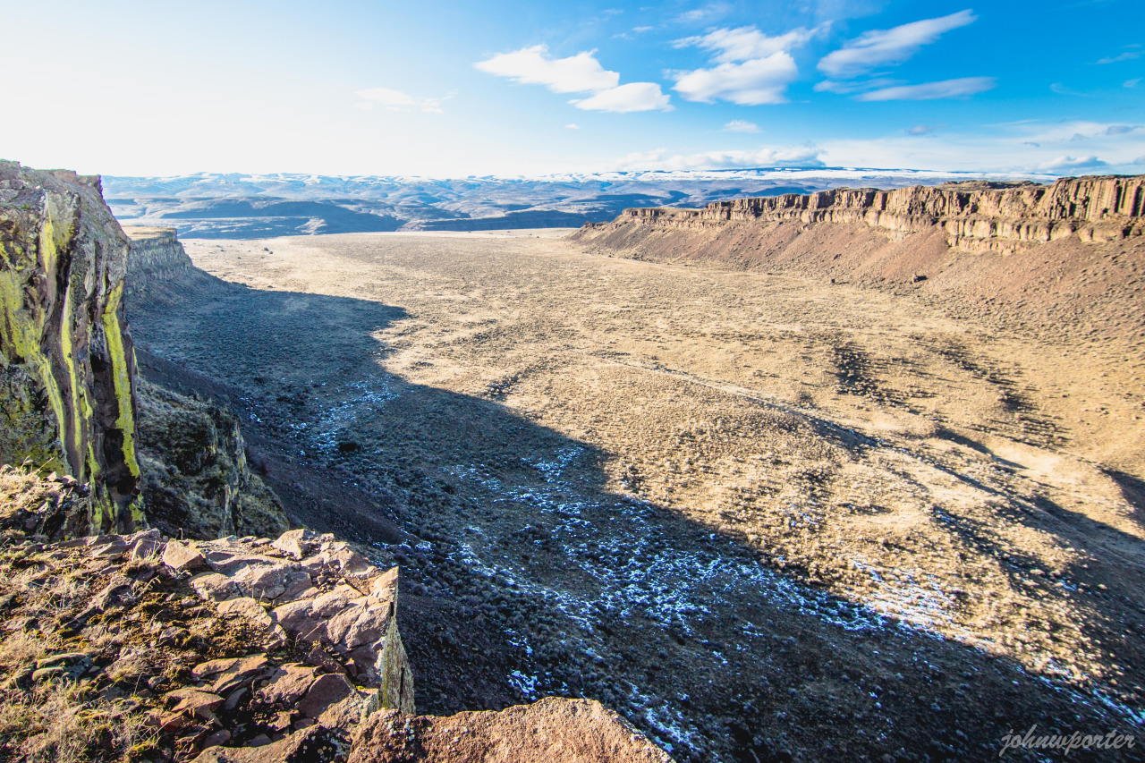
Ice Age Floods Smithsonian Article Devastating Ice Age Floods That Occurred in the Pacific Northwest Fascinate ScientistsThe Scablands were formed by tremendous and rapid change, and may have something to teach us about geological processes on Marsby Riley Black – Science Correspondent – April 19, 2022 for Smithsonian Magazine The Earth seems to change slowly. Continents shift by about half an inch in a year. Sea levels rise by less than a quarter of an inch in the same amount of time. Mountains are constantly being eroded but, to us, seem to stand today just as they did yesterday and the day before. Our planet’s geological history often seems like one of slow, grinding change. But that’s hardly the whole story. Sometimes geological change comes startlingly, violently fast, leaving scars on the Earth’s surface. The Channeled Scablands of the Pacific Northwest, a landscape full of flat-topped plateaus that rise between steep-walled canyons, are among the vastly-altered landscapes that have caused researchers to rethink what they previously presumed. The geologic wounds are dramatic evidence that quick and catastrophic changes have played a significant role in shaping our planet. The Scablands, principally located in southeastern Washington state, bear the signs of an incredible Ice Age event. Between 14,000 and 18,200 years ago, huge glacial lakes on the boundaries of ice sheets burst from their natural dams and rushed over the landscape, scouring the hills and dropping massive stones as they went. Entire hills were washed away as the floodwaters dumped gravel, boulders and sediment in new places, almost like shaking a great geological Etch-a-Sketch. But this is a relatively new understanding, only broadly accepted since the 1970s. It took decades for geologists to construct even an outline of what the Scablands represent, a realization that proved to be a turning point for science. For if intense floods could carve such features once in Earth’s history, surely they could have changed landscapes at other times and in other places—even those as far away as the Martian surface. Geologists only began to pick up on the story of the Scablands a century ago. In the 1920s, naturalist J Harlen Bretz wrote several descriptive papers on the strange basins and odd channels of the area. Those channels had been created by moving water, but the way water had once flowed through the area seemed to make no sense. “The channels run uphill and downhill, they unite and they divide, they head on the back-slopes and cut through the summit,” Bretz wrote, “they could not be more erratically and impossibly designed.” The only reasonable conclusion, Bretz proposed, was that the Scablands were created by massive and short-lived floods. Bretz’s colleagues were not ready for such a conclusion. Ever since geology came into its own as a science in the 19th century, much of the field has been influenced by the concept of uniformitarianism—that the present is the key to the past. In a broad sense, that’s an excellent rule. The Earth is still changing, and many of those alterations—from erosion to volcanic eruptions—also occurred in the past. But some additional stipulations to the older formulation of the idea were unnecessarily taken as truth. One of them was that the Earth is changing at a slow, gradual rate and that quick, catastrophic change was impossible. Bretz’s idea for how the Scablands formed flew in the face of what many geologists accepted. Channels were carved over long periods of time by rivers, other geologists thought, not by sudden floods. To Bretz, the evidence was unmistakable. Among other things, the Scablands contained layers of gravel hundreds of feet high. Slow-moving streams couldn’t have left such vast accumulations. Pieces of gravel are larger and heavier than particles of sand or silt, requiring faster-moving water to pick up the gravel and transport it. Gravel deposits as tall as skyscrapers must have required an incredible amount of fast-flowing water. The pattern was consistent with the underlying geology of the area, as well. The rock beneath the massive flood deposits was relatively friable volcanic rock, easily broken and carved. The fragility of these rock layers allowed the floods to gouge out channels and canyons in a way that harder rocks would have been more resistant to. Yet the fact that Bretz couldn’t identify the source of the floodwaters caused many to dismiss his idea, and it wasn’t until evidence of similar events—such as Ice Age flood beds found in Montana—that other experts began to reconsider what Bretz had proposed. Eventually, by the 1970s, dismissive geologists changed their tune. Something catastrophic truly did transpire to create the Scablands. Not that the behavior or history of such floods are completely understood. “There are loads of outstanding questions and many people are thinking carefully about the Scablands,” says University of Washington geology PhD candidate Kelsay Stanton. Even though experts are confident that vast glacial lakes provided the water for the floods, the precise volumes of the repeated floods are unknown, and the timing of the dozens of outbursts has yet to be determined in detail. “The glacial outburst flooding of the Pacific Northwest is hardly a closed subject,” Stanton says. Part of what’s allowing geologists to keep going back to the Scablands is that the tools available to scientists have changed a great deal since Bretz’s time. “There are lots of geochronology and computer modeling methods now that weren’t available when Bretz and other early researchers were mapping the area,” says University of Massachusetts Amherst geology PhD candidate Karin Lehnigk. These repeated floods affected the ocean, she notes, with the influx of freshwater reducing the saltiness of the northern Pacific for years and altering the way colder, saltier water in deep ocean layers circulated. The floods affected more than the land they ran over, and have acted as models for how our modern glaciers might alter ocean circulation as they melt due to global warming. New, broad scale methodologies can offer some of these insights and these refined techniques have proved to be critical, as no one has ever
April IAFI Newsletter is Published
Our quarterly newsletter was published Friday, April 15 with some good ideas for exploring the Ice Age Floods. However, we’re again finding that several member’s inboxes or internet providers have assigned the email deliveries to Spam folders. If you are an IAFI member and didn’t receive the newsletter please email newsletter@iafi.org after you check your Spam folder. If one or both emails are in Spam please mark them as NOT SPAM to ensure proper delivery in the future from the email addresses we use. Meanwhile, here is a window displaying the online version of the April IAFI Newsletter, ENJOY!
Scholars Trek on the Ice Age Floods Trail

Ice Age Floods Fourth Grade Curriculum Development One of the missions of the Ice Age Floods Institute is to educate young people about the Floods and the influence of the Floods on their lives today. The IAFI Educational Outreach Committee has contracted with the curriculum design firm The Inspired Classroom to produce engaging lesson materials to excite fourth-grade students from across the Northwest about the Ice Age Floods. The curriculum will contain video footage narrated by experts and lesson plans for use by fourth grade teachers in Montana, Idaho, Washington and Oregon. The story, entitled “Scholars Trek on the Ice Age Floods Trail,” will begin with a flyover video of the trail, including Glacial Lake Missoula, the Clark Fork Ice Dam, the Rathdrum Prairie, Spokane Falls, the Channeled Scabland, Lake Lewis, the Columbia River Gorge, Lake Allison, and the deposition of the eroded sediment on the continental shelf at the mouth of the Columbia River. Along the route, students will be introduced to the ways in which the Floods influence society today, including the influence of the Floods on the Spokane Aquifer and on railroad and highway routes across the Pacific Northwest. Funding for the project will come from grants, the IAFI, and from private benefactors. The continued support of IAFI members through membership dues and donations helps fund projects like this. The Education Committee is made up from a sampling of IAFI Board Members and Chapter Presidents from each state: Jim Shelden (Glacial Lake Missoula); Tony Lewis (Coeur du Deluge); Melanie Bell and Consuelo Larrabee (Cheney-Spokane); Gary Kleinknect (Lake Lewis) and Dale Lehman (Puget Lobe.) In the future, the Education Committee plans to work on curriculum materials for middle and high school students. By Dale Lehman, 04/14/2022
Explore the Columbia River Gorge
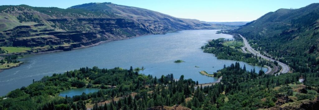
The Columbia River Gorge is an incredibly popular area to visit, and that’s for good reason, the setting is uniquely spectacular. The Gorge encompasses: Easily accessible ecozones that range through boreal conifer forests, oak woodlands, high desert grasslands and alpine environments in only 40 miles, Dazzling viewpoints and scenery, including beautiful waterfalls that cascade over the high basalt ramparts that bound the relatively narrow Gorge and the majestic Columbia River running through it, Mt. Adams, Mt. St. Helens and Mt. Hood, imposing snow-covered stratovolcanoes lying less than 40 miles north and south of the Gorge, Picturesque small towns that are bounded by extensive federally- and state-protected natural areas throughout the length of the Gorge, Abundant recreation opportunities including hiking, road/mountain biking, windsurfing and kiteboarding, whitewater kayaking and rafting, fishing, hunting, alpine/cross-country skiing and snowshoeing, Numerous award-winning wineries and breweries, restaurants and pubs, shops, galleries, museums, parks, hotels and campgrounds, And all this is lying at the back doorstep of Portland, Oregon. The Gorge is also a geologic wonderland, exposing stories about: The 40 million year history of the Columbia River, The series of massive Columbia River Basalt flows 18-12 million years ago, The rise of the Cascade Mountain Range since about 5 million years ago, The passage of numerous, up to 1000 feet deep Ice Age Floods that reshaped the Gorge 18-14 thousand years ago, Tectonic faulting and folding, landslides, earthquakes, forest fires, and The often intertwined lives and stories of the people who have lived here. Of course, with all this bounty the area is also a robust tourist mecca, which can mean limited accommodations for summer crowds. Most attractions are easy to drive to, but bus tours and river cruises are also available. Due to the popularity, some of the iconic attractions now seasonally restrict vehicle access and require permits.
Traveling the Ice Age Floods National Geologic Trail
In September 2021 my wife and I took a trip to see what was new along the Ice Age Floods National Geologic Trail and visit some places we did not make it to in our very first trip in 2004. The IAFI chapter brochures were very helpful in learning what there was to see in each area. We also remembered a preview of the National Parks Service unigrid map brochure that will come out hopefully later this year, so be sure and get one when it debuts. The other excellent tool was the online interactive map on the Ice Age Floods Institute website (https://iafi.org/floodscapes/), where you can click on a spot and see a photo and description of the site. All are great planning tools. We drove to Missoula, Montana and stayed there a couple of days as we made day trips. Our first one was to Ovando to see a granite glacial erratic that the Glacial Lake Missoula Chapter had etched and placed at the high-water line. You will find it at Trixi’s Antler Saloon which is a nice place to grab a bite for lunch. The chapter has a number of these high water markers placed already and have more planned to show the full extent of Glacial Lake Missoula. Unfortunately, due to the smoke from the wildfires we were not able to go to Hamilton to see the 8-ton granite erratics outside Ravaili Museum with four interpretive signs outside and additional displays inside. We drove up to the Paradise Center in Paradise, Montana. We had been there before in 2016 for the fall IAFI field trip and they were just dreaming of what the old Paradise Elementary School could become. They have done a wonderful job of making that dream come true. It was one of our favorite spots on this trip. They have dedicated an entire room to the Ice Age Floods story where an extremely accurate 3-D map of Glacial Lake Missoula has lights installed so you can push a button to light up the edge of the ice lobe and other features. Besides information about the Ice Age Floods, the Center also has wonderful displays about the trains & train yard that used to be in Paradise and the history of the Paradise Elementary School. We went to the Natural History Museum in Missoula and enjoyed the panels and video which told the Lake Missoula Floods story and also about Joseph Pardee, a very important pioneer in solving the mystery of these Floods. This museum also displays an amazing amount of taxidermy showing the wildlife and birds in the region. On our way up to Sandpoint, Idaho we passed through Eddy Narrows. Glacial Lake Missoula drained through this canyon going 80 mph leaving horizontal marks high up on the walls. Previously these were thought to be glacial striations, but Pardee speculated that these marks were from huge boulders as they shot through the Narrows. The Narrows is long with few places you can pull over on Highway 200, so it can be hard to really appreciate its scope. We got a good view from the Koo-Koo-Sint Bighorn Sheep Viewing Interpretive Site which has several interpretive signs that talk about the sheep and the geology of the Clark Fork River Valley. We then went over to Farragut State Park at the southern tip of Lake Pend Oreille to view the beginning of the outburst plain that formed the Rathdrum/Spokane Valley aquifer. Across Lake Pend Oreille is Green Monarch Ridge; the terminus of the Purcell Trench which held the 4,000 ft. ice dam that carved the steep walls. The display at the museum has several interpretive panels. The next day we met Consuelo Larrabee who gave us a personal tour of the 40,000 square foot Ice Age Floods Playground in Riverfront Park in Spokane, Washington. She and Melanie Bell, the president of the Cheney-Spokane chapter, did an enormous amount of work as consultants on this fabulous, themed park. Kids can learn as they play on the three-story Columbian slide tower, Glacial Dam splash pad, log jam climber, an alluvial deposit fossil dig, and more. The park was filled with kids and the adults were enjoying it as much as the kids. We loved watching the excitement of a child as she saw the splash pad water fountains simulate the ice dam starting to rupture and then the cascade of water flooding over the manmade basalt rocks. Along the side of the building are actual basalt columns and the fossil dig led to many exciting discoveries by the children as they dug through the sand to reveal embedded replicas of fossils. Throughout the park are thoughtfully placed benches for people to sit and watch the fun going on around them. There are nine interpretive panels throughout the park adding a wonderful educational benefit to all the fun. This park will be quite a prize for years to come. The next day we drove along Highway 262 to W. McManamon Road to the Drumheller Channels National Natural Landmark. This outlet from the Quincy Basin, with floodwaters going 65 mph eroded not just the topsoil but the underlying basalt which created dramatic channels, basins, potholes and buttes. The viewpoints along the drive had several interpretive panels talking about these wonderful vistas. Since we live in Portland and this trip was to see places we had not recently seen, we skipped over the many wonderful places in the Columbia River Gorge, Willamette Valley & Tualatin. But for your trip, please check out the hundreds of beautiful and interesting sites to see in this region. The last stop for this trip was Cape Disappointment. The Floods debris flushing out the mouth of the Columbia River added substantially to submarine Astoria Fan and sediment cores have shown that ocean currents carried some of this debris all the way down to Cape Mendocino, California. Although not visible from the surface, the Park display has a relief map that shows the Astoria Canyon
Riverfront Park IAF Playground – Information Panels Installed

Permanent information panels have been installed in the Ice Age Floods Playground in Spokane’s Riverfront Park. The panels briefly describe: Fire: Basalt & Columnar Basalt Ice: Cordilleran Ice Sheet Water: Missoula Floods Rhythmites & Varves Erratics & Granite Giant Current Dunes Animals: Columbian Mammoths Animal Fossils The panels have a heavy duty permanent covering, impervious to weather & wanton destruction. They will add greatly to the experience of this special and very popular space. The Ice Age Floods Playground is a spectacular addition to Spokane’s Riverfront Park that is well worth a visit for kids and adults alike.
Initial Member Survey Results

Earlier this year we sent out our first IAFI member survey. A big THANK YOU to the 154 members who responded, an outstanding 30% response rate. You’re helping us see what we’re doing right, understand where we can improve, and where we should direct our efforts. Most of the responses affirm that we are doing a lot of things right at the national and chapter level to fulfill our Mission, “IAFI is committed to being a recognized advocate, educator, and marketer of the Ice Age floods experience as a significant international, natural and cultural heritage phenomenon.” We appreciate your confidence in our efforts and the fresh ideas you offered that are helping us think outside the box. We are particularly pleased at your enthusiasm for our public lectures, field trips, website content, our brochures and our newsletter. Though there was strong support for our chapter lectures, both in-person and Zoom, and for the recordings to be posted to YouTube for later viewing (22 new subscribers, 1,440 total views with nearly 400 viewing hours just last month alone), we are somewhat concerned to find that several members are not familiar with our YouTube channel, nor with our online IAFI Store. Direct links to these features can be readily found in the upper right area of our homepage at IAFI.org. Our IAFI YouTube playlists include links to a large and growing number of chapter presentations, geology lectures, and other Floods-related video recordings. Our online IAFI Store offers a number of Floods-related items, including books, maps, our very popular chapter brochures, clothing, prints, posters and more. As each chapter reviews their specific survey results and comments, you may see some changes and tweaking of the programs within your chapter. There were also suggestions for larger projects which will require action from the board and/or multiple chapters. These suggestions will be reviewed, discussed and prioritized at the IAFI board meeting in May. We will then present our plans for these ideas in the July Pleistocene Post, and will be looking for help from our members to bring them to fruition.