Initial Member Survey Results

Earlier this year we sent out our first IAFI member survey. A big THANK YOU to the 154 members who responded, an outstanding 30% response rate. You’re helping us see what we’re doing right, understand where we can improve, and where we should direct our efforts. Most of the responses affirm that we are doing a lot of things right at the national and chapter level to fulfill our Mission, “IAFI is committed to being a recognized advocate, educator, and marketer of the Ice Age floods experience as a significant international, natural and cultural heritage phenomenon.” We appreciate your confidence in our efforts and the fresh ideas you offered that are helping us think outside the box. We are particularly pleased at your enthusiasm for our public lectures, field trips, website content, our brochures and our newsletter. Though there was strong support for our chapter lectures, both in-person and Zoom, and for the recordings to be posted to YouTube for later viewing (22 new subscribers, 1,440 total views with nearly 400 viewing hours just last month alone), we are somewhat concerned to find that several members are not familiar with our YouTube channel, nor with our online IAFI Store. Direct links to these features can be readily found in the upper right area of our homepage at IAFI.org. Our IAFI YouTube playlists include links to a large and growing number of chapter presentations, geology lectures, and other Floods-related video recordings. Our online IAFI Store offers a number of Floods-related items, including books, maps, our very popular chapter brochures, clothing, prints, posters and more. As each chapter reviews their specific survey results and comments, you may see some changes and tweaking of the programs within your chapter. There were also suggestions for larger projects which will require action from the board and/or multiple chapters. These suggestions will be reviewed, discussed and prioritized at the IAFI board meeting in May. We will then present our plans for these ideas in the July Pleistocene Post, and will be looking for help from our members to bring them to fruition.
Puget Lobe Chapter Field Trips

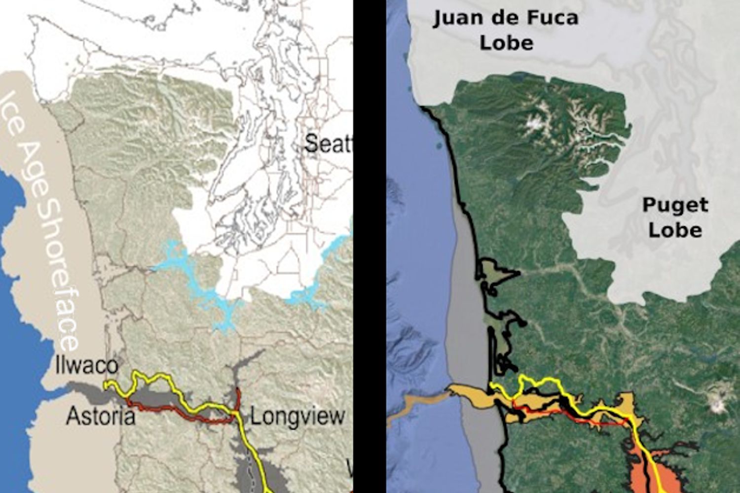
The Puget Lobe Chapter sponsored field trips enable IAFI members and the public to join in these educational opportunities. The Puget Sound area is remarkable for Cordilleran Continental Ice Sheets that issued forth from British Columbia and abrading and deforming the area between the Cascades and Olympic Mountains from the area to the Pacific Ocean “north” of the Olympics and there called the Juan de Fuca Lobe. “North” is a relative term, as the Last Glacial Maximum (LGM) was a condition of the ice sheet size at any given time. For example, the Double Bluff Glaciation LGM (190 Kya – 130Kya {T2*}) extended to ≅Tenino, while the Puyallup Glaciation (80-59Kya) LGM only extended ≅ Bremerton. The Fraser Glaciation (30Kya – 15Kya {T1 at 11Kya}) LGM terminated just below Olympia. We also had Alpine Glaciation in the Cascade and Olympic Mountains. For example, prior to the Fraser ice sheet flowing into the Puget trough, the alpine glaciers had advanced and receded from the same area (LGM 22Kya). (Note: T2 and T1 are Termination Points) The Puget Sound area was isolated by the Cascades Range from the large number of ice sheet lobes found in Eastern Washington, Idaho, and Montana, Similarly, we were isolated from the Missoula Floods and the effects of those floods which rampaged down the Columbia River and turned west at Longview – a mere 20-30 miles south of the Puget Lobe LGM. Yes, all the ice lobes in our area were called “Puget Lobe” except where the Puget Lobe couldn’t get past the Olympics. Forced to take a westerly turn towards the Pacific Ocean, that was called the Juan de Fuca Lobe. The first of our four Spring Field Trips: 1. Building Stone of Seattle, (Completed) 2. Ice Age geology of the Snoqualmie Valley, (full not accepting participants) 3. June 1-3: Frenchman Springs Coulee and the Ice Age Floods This trip is completed 4. June 30: The Advance and Retreat of the Cordilleran Ice Sheet Revealed at Discovery Park This trip is completed
What Did You Do for Geologist’s Day?
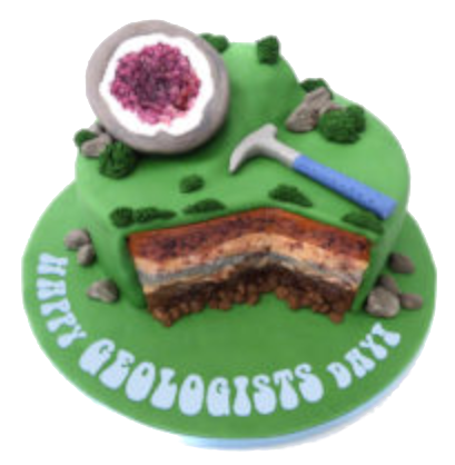
Geologists Day, a day dedicated to an underappreciated science, takes place on the first Sunday in April every year. Without geologists, we would know nothing about the over 4.5 billion year history of the earth. Geology is a science that studies the materials, natural features, and processes found on earth, as well as the history of all life that’s ever lived. Geologists around the world have made an enormous contribution to our way of life by discovering and developing our natural resources of minerals, hydrocarbons and water, by understanding the evolution of our planet and our solar system, by defining the evolution of life on Earth, by identifying the risks associated with natural hazards such as earthquakes, tsunamis and volcanic eruptions, and by the technological and innovation spin-offs derived from many branches of geoscience such as geophysics and geochemistry. History of Geologists’ Day Geology, or the study of the composition of rocks, soil and other materials, has been around since the times of Ancient Greece. In their pursuit of understanding the world around them, Greek scientists, who wondered how the rocks were formed, began studying fossils and generating theories to go along with their ideas and research. Later, during the Middle Ages, when science was thought to have challenged the Catholic Church, more advances came (albeit sometimes subversively) in the field of geology. During this time, Leonardo da Vinci explored the functions of the human body but also, one of his lesser-known pursuits, is that he became a pioneer in geology. One of da Vinci’s interesting lines of research was related to fossils. He concluded that the fossils he and others had found embedded on mountain tops must have been from animals that swam on an ancient sea bed, though none of them were exactly sure how they could have gotten there. During the 17th-century, scientists began to make important links between certain sedimentary deposits in the oceans and the strata observable in rock formations. Much of the explanation as to how that happened, however, continued to remain a mystery until James Hutton and William ‘Strata’ Smith came along. These two well-known geologists helped find the explanation of the earth’s long and slow development over the course of thousands of years. Smith was also credited as the creator of the first, geologically detailed, national map of any country in the world. In this case, the country was England and he has since become known as the ‘Father of English Geology’. Geologists’ Day, itself, was actually the idea of a group of well-known Soviet geologists who established it in April, 1966. The day was chosen in the spring because it notes the end of winter and is a time that ramps up to the summer season field work when geologists are so active. While it continues to be a favorite day of the Russian Mineralogical Society, the day eventually made its way beyond the former Soviet Union and began to be celebrated by geologists, geophysicists and geochemists in various places in Europe, the United States and other countries around the world. How to Celebrate Geologists’ Day Held on the first Sunday in April, the celebration of Geologists’ Day can be fun for professional rock lovers and hobbyists alike! This day strives to help further the study of how the earth came to be. Geologists’ Day is all about learning the history of the earth, the geologists who studied the earth, and helping to inspire people out there to study geology. Learn More About Geology Give a nod to Geologists’ Day by learning a bit about what the discipline of geology is and how it works. Digging in rocks, observing maps, and studying how they all came to be is what a geologist’s job is all about. Make use of these online resources to learn more about geology: Ice Age Floods Institute website The Geological Society of America Society of Economic Geologists International Association for Promoting Geoethics Those who are even more interested might take the time to join a few online classes to further their studies. Take a look into the history of geologists, what they believed about the earth at the time they lived. If it turns out there’s an inner rock-lover in there, just waiting to get out, why not go for a degree while you’re at it?! Show Appreciation to a Geologist Geologists’ Day aims to show appreciation for the geologists that continue to study rocks and all their formations. In fact, this is the perfect day to gather with some friends or family to thank some of those favorite geologists, or even just a science teacher, who may have made a difference in the understanding of the world we live in. Listen to a Geology Themed Playlist Hop onto Spotify or another favorite music hosting site and enjoy these songs that are reminiscent of the study of the earth, rocks, landslides and all the beautiful things that go along with geology: We Will Rock You (1977) Queen The Geologists are Coming! (2017) The Amoeba People Landslide (1975) Fleetwood Mac The Petroleum Age (2011) Philip Gibbs Geology Rocks (2017) Los Beekeepers Uranium Rock (1973) Warren Smith Sweet Geology (aka The Mineral Song) (2007) The Akkademiks Share Geology Day with Friends Show appreciation for the studies of geologists by sharing this holiday with friends and family. Go big by throwing a geology party, or keep it small by simply gifting friends or coworkers with a small stone or rock as a token of the day. Whatever method is chosen, just the acknowledgment of this day is a step in the right direction toward appreciating the earth and its scientists! (credit https://www.daysoftheyear.com/days/geologists-day/)
First Americans Toxic Debate Hobbled Archaeology for Decades
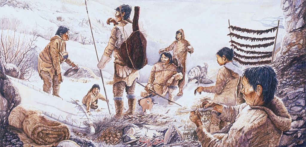
Bluefish Caves directly challenged mainstream scientific thinking. Evidence had long suggested that humans first reached the Americas around 13,000 years ago, when Asian hunters crossed a now submerged landmass known as Beringia, which joined Siberia to Alaska and Yukon during the last ice age. From there, the migrants seemed to have hurried southward along the edges of melting ice sheets to warmer lands in what is now the United States, where they and their descendants thrived. Researchers called these southern hunters the Clovis people, after a distinctive type of spear point they carried. And the story of their arrival in the New World became known as the Clovis first model. Jacques Cinq-Mars, however, didn’t buy that story—not a bit.
Earth Appears to Have a 27.5-Million-Year ‘Heartbeat’
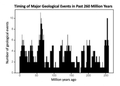
Geologists have been investigating a potential cycle in geological events for a long time. A recent analysis on the ages of 89 well-understood geological events from the past 260 million years show a catastrophic 27.5 million year pulse in eight clusters of world-changing geologic events over geologically small timespans. This pulse of clustered geological events – including volcanic activity, mass extinctions, plate reorganizations, and sea level rises – is incredibly slow, a 27.5-million-year cycle of catastrophic ebbs and flows. As you can see from the graph, some of those times were tough – with over eight of such world-changing events clustering together over geologically small timespans, forming the catastrophic ‘pulse’. “These events include times of marine and non-marine extinctions, major ocean-anoxic events, continental flood-basalt eruptions, sea-level fluctuations, global pulses of intraplate magmatism, and times of changes in seafloor-spreading rates and plate reorganizations,” the team writes in their paper. These cyclic pulses of tectonics and climate change may be the result of geophysical processes related to the dynamics of plate tectonics and mantle plumes, or might alternatively be paced by astronomical cycles associated with the Earth’s motions in the Solar System and the Galaxy. Luckily for us, the research suggests we have another 20 million years before the next ‘pulse’.
First Peoples Ice-Free Corridor Migration to Americas Reexamined
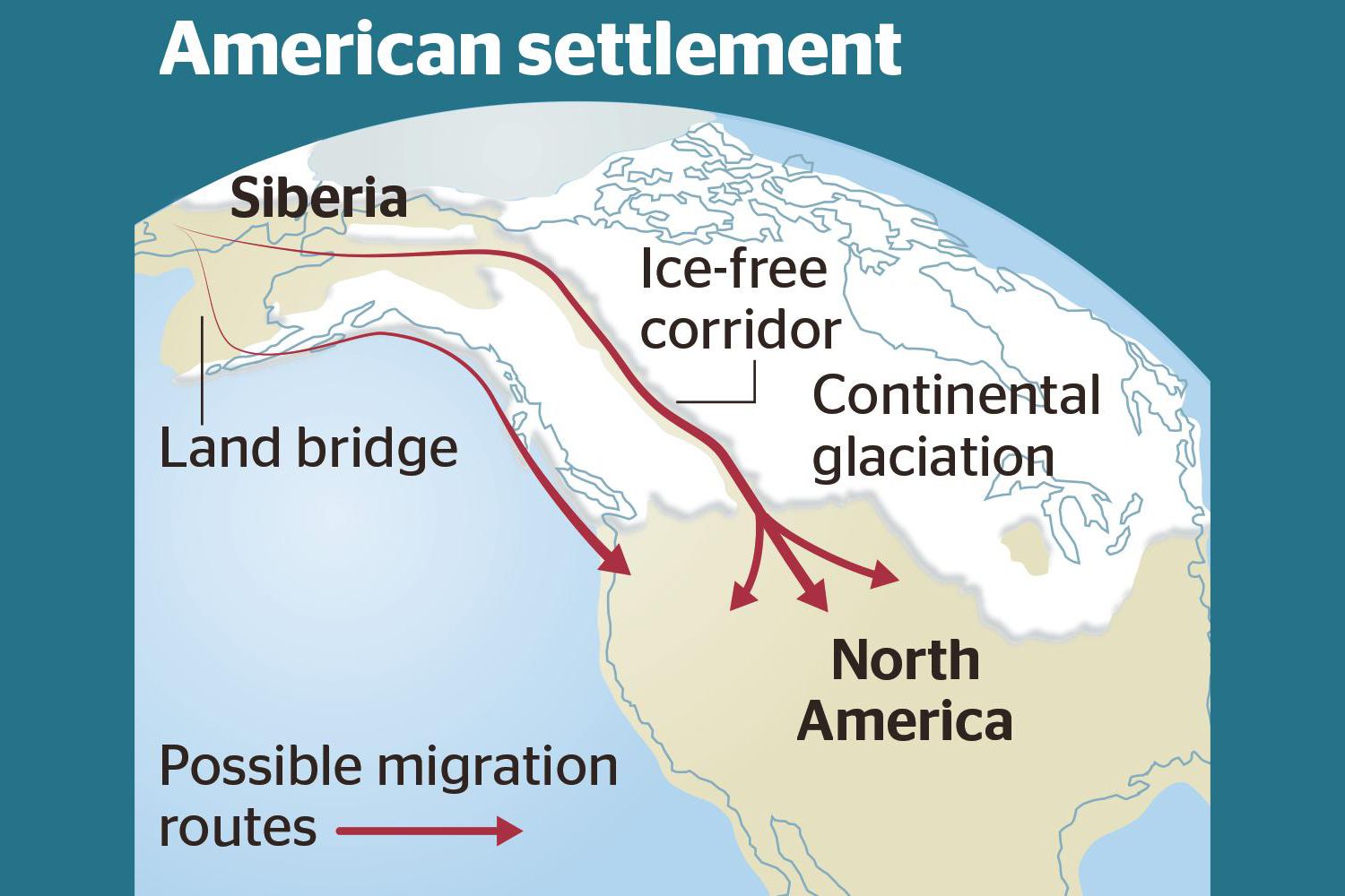
Analysis of how long erratics have been exposed on ice-free ground in the hypothesized “Late Pleistocene ice-free corridor migration route” suggests that route was not fully open until about 13,800 years ago, and the ice sheets “may have been 1,500 to 3,000 feet (455 to 910 m) high in the area where they covered the ice-free corridor,” according to study lead author Jorie Clark, a geologist and archaeologist at Oregon State University. Clark said, “we now have robust evidence that the ice-free corridor was not open and available for the [Late Pleistocene] first peopling of the Americas.” If evidence of humans in the Americas prior to the 30,000 years ago is ultimately found, that evidence does not preclude the possibility of ice-free corridor migration before closure of the corridor.
Humans in the Beringia Yukon ~24,000 Years Ago
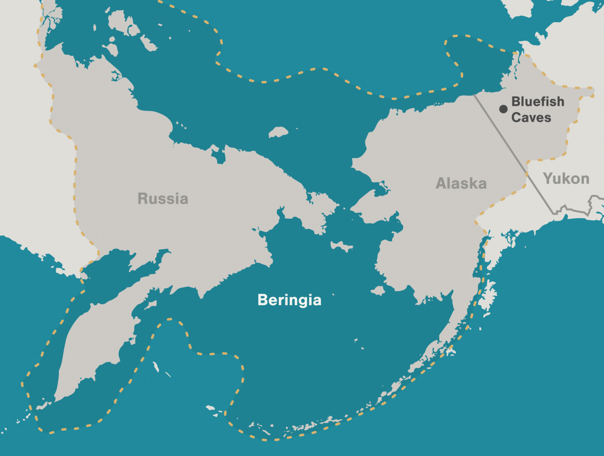
Archaeologists have long debated how and when people entered the Americas. Throughout the 20th century, the mainstream hypothesis was that the Clovis people were the first to pass into Alaska about 13,000 years ago. Stemming from his excavations between 1977 and 1987 at the Bluefish Caves in northwestern Yukon, Jacques Cinq-Mars, a Canadian archaeologist, unearthed evidence that hunters were using the site some 24,000 years ago. Lauriane Bourgeon, a French archaeologist, has spent much of her career re-examining and dating the Bluefish Caves collection to clarify the history of the contentious site. Her research has shown that at least 15 bones from the Bluefish Caves were cut-marked by people as early as 23,500 years ago.
Asteroid That Decimated the Dinosaurs May Have Struck in Spring
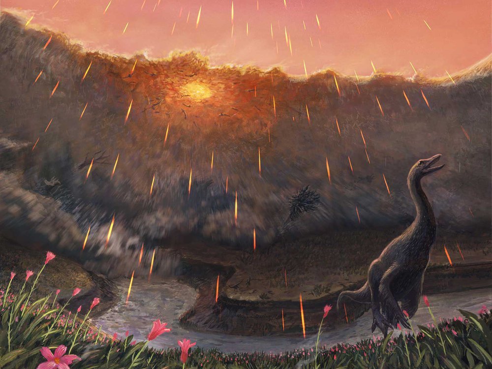
Spring may have been when a roughly seven-mile-wide asteroid struck the Earth, immediately triggering the mass extinction that would wipe out 76 percent of known species. That key piece of timing doesn’t come from dinosaurs, but from the fish that swam in the waters dinosaurs drank from. By studying the fossil bones of these fish and comparing them to their modern counterparts, Vrije Universiteit Amsterdam paleontologist Melanie During and colleagues have come to the conclusion that the impact that ended the Age of Dinosaurs most likely occurred in the spring. Like their modern counterparts, ancient sturgeons and paddlefish of the Hell Creek Formation, found in the “Tanis” fossil site in North Dakota, grew in cycles. Those researchers proposed that this place contains critical clues about the first minutes and hours of what transpired after impact—including well-preserved fossil fish that contain asteroid impact debris in their gills. During warmer months when food was plentiful, the ancient fish grew and added more bone tissue just as their modern relatives do. During cooler, harsher months, however, their growth slowed and left a line—called a line of arrested growth, or LAG—in their bones. In addition, the bones of these fish contained signatures from oxygen and carbon isotopes. The geochemical signals in these isotopes were influenced by what the fish were eating and the waters they swam in, a natural phenomenon that has been used by paleontologists to study everything from when early whales took to the seas to what plants ancient herbivores ate. Details of the prehistoric sturgeon and paddlefish bones indicate that these fish had not yet hit the peak of their annual growth spurt, which would be expected during the warmest parts of the year. The carbon isotope ratios in the paddlefish bones also match up with this pattern. If these ancient fish lived according to a similar annual cycle as their living relatives, then the signatures in their bones hint that they perished in spring. The fact that tiny spherules thrown into the air during the impact were found in their gills places the time of death within minutes or hours of the end-Cretaceous impact. Together, these lines of evidence suggest that the impact took place while the Northern Hemisphere was in spring and the Southern Hemisphere was still in winter. Read more in the Smithsonian Magazine article by Riley Black that this was taken from, or a Science Alert article that also recaps the paper published in Nature.
Waning Pleistocene Ice Sheet Affected Megaflood Paths and Local Shorelines
Have you ever thought about the how the weight of the ice-age Cordilleran ice sheet might affect the underlying Earth’s crust. There is strong evidence that the crust was depressed hundreds of feet beneath the ice, and since the crust is relatively thin and rigid over a plastic aesthenosphere, that also caused the crust for some distance beyond the ice margins to tilt toward the ice sheet. A new modeling study explored how changes in topography due to the solid Earth’s response to ice sheet loading and unloading might have influenced successive megaflood routes over the Channeled Scablands between 18 and 15.5 thousand years ago. The modeling found that deformation of Earth’s crust may played an important role in directing the erosion of the Channeled Scabland. Results showed that near 18 thousand year old floods could have traversed and eroded parts of two major Channeled Scabland tracts—Telford-Crab Creek and Cheney-Palouse. However, as the ice-age waned and the ice sheet diminished 15.5 thousand years ago, crustal isostatic rebound may have limited megaflood flow into the Cheney–Palouse tract. This tilt dependent difference in flow between tracts was governed by tilting of the landscape, which also affected the filling and overspill of glacial Lake Columbia directly upstream of the tracts. These results highlight one impact of crustal isostatic adjustment on megaflood routes and landscape evolution. Other studies have shown that relative ice-age sea levels were over 300 feet lower worldwide due to the volume of water locked up in ice sheets. Typical depictions of the shoreface extent are generally based on a 300 ft. depth contour, but there is strong evidence that shorelines were up to 200+ ft. higher than present day in marine areas adjacent to ice sheets, again because the crust was depressed by the weight of the ice sheer. A more accurate representation might show a much narrower shoreface in ice-free areas nearer to the ice sheet margin. However, in the Haida Gwaii Strait at the margin of the ice sheet the lower thickness of the ice sheet meant that local shorelines were as much as 550 feet lower than they are today. This was because the much greater thickness of the center of the ice sheet served to push upwards areas at the edge of the continental shelf in a crustal forebulge. It is now widely thought that these emergent ice-free land areas might have provided a viable coastal migration corridor for early peoples making their way to the Americas from Asia during the Pleistocene.
Visitor Centers are Rolling In on the IAF National Geologic Trail
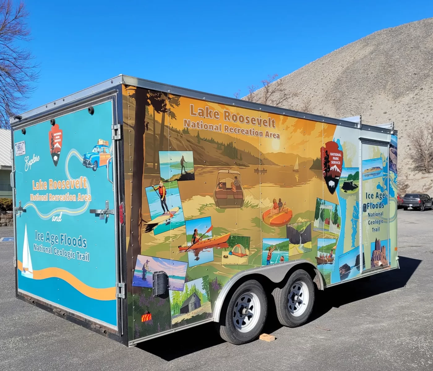
The Ice Age Floods National Geologic Trail now has an official Visitor Center, and there’s another one coming. The NPS doesn’t actually own any land for a permanent Visitor Center on the Trail, but in keeping with the spirit of the Trail these beauties will vagabond around the trail. Ideally, in this way they will reach many more people than a fixed building could. Kudos to the Lake Roosevelt NRA staff who early-on adopted official responsibility for the nascent Trail and continues to be the administrative hub and a driving force behind the Trail. After many moons of hard work, the first trailer (of two!) was delivered yesterday. Inside are exhibits on the critters, rocks, history, and more of the area! The sides are decorated with illustrations of people boating, fishing, hiking, camping, and playing in Lake Roosevelt, as well as scenic views along Lake Roosevelt. A wavy line and National Park Service arrowhead symbol separate the Ice Age Floods National Geologic Trail section, which has illustrations of geologic formations. They tell the story of the #IceAgeFloodsNGT as well as Lake Roosevelt NPS. We’re beyond excited to share them with you this summer. Keep your eyes peeled on the Ice Age Floods National Geologic Trail NPS Facebook page for future updates to know when and where to find them!