Ancient British Isles Ice Sheet Time-Lapse Animation

The rapid decline of the British-Irish Ice Sheet thousands of years ago may hold lessons for how melting ice sheets in Greenland and Antarctica will influence sea-level rise in the future. In an animation that spans tens of thousands of years, an ancient ice sheet grows to envelope land masses that would one day be known as Great Britain and Ireland. After thousands of years elapse, the ice then retreats to expose the land once more. Known as the British-Irish ice sheet, the frozen mass began its relentless march about 33,000 years ago. Around 10,000 years later, the land was covered in ice half a mile thick. But just 5,000 years after that, the glacier had melted away, vanishing in a mere blink of geological time. Human populations that had fled a millennia-long winter returned to settle the thawing land just as the last ice age drew to a close. Representing years of research, this animation highlights how quickly the British-Irish Ice Sheet declined. And the data driving the animation may help scientists to better understand how modern ice loss due to climate change contributes to sea-level rise.Scottish geologist Archibald Geikie first mapped the British-Irish Ice Sheet’s shape in 1894 and, over the past century, scientists have slowly carved out details of its formation and decline, publishing their findings in more than 1,000 scientific publications, according to the website of BRITICE-CHRONO(opens in new tab) a five-year, $4.2 million endeavor to map the British-Irish Ice Sheet. Ultimately it was the specter of human-caused climate change that drove one team of BRITICE-CHRONO researchers to bring together existing data and collect more; they published their findings Sept. 7 in the journal Boreas(opens in new tab). In creating the new animation, the scientists visualized the most complete picture to date of the ancient ice sheet’s rise and fall. The BRITICE-CHRONO team scoured prior studies and compiled data on more than 20,000 landforms that currently exist along the path of the ice sheet — from hill-like drumlins, or small ridges, to masses of soil and rock left behind by the moving glacier. The scientists then visited locations on land and sea, collecting data from 914 sites — some of which were only accessible via submarine, they reported in the study. They calculated the geometric contours of the ice sheet from features in the terrain, estimating the timing of the glacier’s retreat from carbon-dated sediment, including animal remains. Their efforts produced three times more data than any prior simulation of the British-Irish ice sheet; the team then fed the data into a computer model that assessed how the ice would have interacted with its environment over tens of thousands of years. Their animation presented the resulting maps as a time-lapse of the glacier’s expansion and eventual demise. Although this particular ice sheet melted thousands of years ago, the details of its growth and collapse may hold lessons for climate scientists studying the alarming decline of two modern ice sheets: one in Antarctica and the other in Greenland. Since 1901, these two ice sheets have lost 49,000 gigatonnes of ice — enough to coat the United States in 22 feet (6.7 meters) of ice, or enough to cover the entire surface of the moon in an ice sheet five feet (1.5 m) tall, according to NASA(opens in new tab). That melted ice ended up in the ocean, where it has been the single largest contributor to sea-level rise in the past few decades, according to the United Nations’ International Panel on Climate Change(opens in new tab). Even if humans were to cut all fossil fuel emissions tomorrow, a 2022 study in Nature Climate Change(opens in new tab) suggests that ice lost from the Greenland ice sheet would still cause a 10-inch (25-centimeter) sea level rise. Rising sea levels, in turn, will likely mean more punishing storms with worse flooding; the disruption of fragile ecosystems; and the mass displacement of millions of people who live along the coast. Projects such as BRITICE-CHRONO, which look back at the lifespans of long-gone ice sheets, may help scientists predict the decline of modern ice sheets and plan for the future, the researchers reported. Article by Joshua A. Krisch, taken from Live Science
How Galactic Rhythms Helped Form Earth’s Continental Crust

“To see a world in a grain of sand”, the opening sentence of the poem by William Blake, is an oft-used phrase that also captures some of what geologists do. We observe the composition of mineral grains, smaller than the width of a human hair. Then, we extrapolate the chemical processes they suggest to ponder the construction of our planet itself. Now, we’ve taken that minute attention to new heights, connecting tiny grains to Earth’s place in the galactic environment. Looking out to the universe At an even larger scale, astrophysicists seek to understand the universe and our place in it. They use laws of physics to develop models that describe the orbits of astronomical objects. Although we may think of the planet’s surface as something shaped by processes entirely within Earth itself, our planet has undoubtedly felt the effects of its cosmic environment. This includes periodic changes in Earth’s orbit, variations in the Sun’s output, gamma ray bursts, and of course meteorite impacts. Just looking at the Moon and its pockmarked surface should remind us of that, given Earth is more than 80 times more massive than its gray satellite. In fact, recent work has pointed to the importance of meteorite impacts in the production of continental crust on Earth, helping to form buoyant “seeds” that floated on the outermost layer of our planet in its youth. We and our international team of colleagues have now identified a rhythm in the production of this early continental crust, and the tempo points to a truly grand driving mechanism. This work has just been published in the journal Geology. The rhythm of crust production on Earth Many rocks on Earth form from molten or semi-molten magma. This magma is derived either directly from the mantle – the predominantly solid but slowly flowing layer below the planet’s crust – or from recooking even older bits of pre-existing crust. As liquid magma cools, it eventually freezes into solid rock. Through this cooling process of magma crystallization, mineral grains grow and can trap elements such as uranium that decay over time and produce a sort of stopwatch, recording their age. Not only that, but crystals can also trap other elements that track the composition of their parental magma, like how a surname might track a person’s family. With these two pieces of information – age and composition – we can then reconstruct a timeline of crust production. Then, we can decode its main frequencies, using the mathematical wizardry of the Fourier transform. This tool basically decodes the frequency of events, much like unscrambling ingredients that have gone into the blender for a cake. Our results from this approach suggest an approximate 200-million-year rhythm to crust production on the early Earth. Our place in the cosmos But there is another process with a similar rhythm. Our Solar System and the four spiral arms of the Milky Way are both spinning around the supermassive black hole at the galaxy’s center, yet they are moving at different speeds. The spiral arms orbit at 210 kilometers per second, while the Sun is speeding along at 240km per second, meaning our Solar System is surfing into and out of the galaxy’s arms. You can think of the spiral arms as dense regions that slow the passage of stars much like a traffic jam, which only clears further down the road (or through the arm). This model results in approximately 200 million years between each entry our Solar System makes into a spiral arm of the galaxy. So, there seems to be a possible connection between the timing of crust production on Earth and the length of time it takes to orbit the galactic spiral arms – but why? Strikes from the cloud In the distant reaches of our Solar System, a cloud of icy rocky debris named the Oort cloud is thought to orbit our Sun. As the Solar System periodically moves into a spiral arm, interaction between it and the Oort cloud is proposed to dislodge material from the cloud, sending it closer to the inner Solar System. Some of this material may even strike Earth. Earth experiences relatively frequent impacts from the rocky bodies of the asteroid belt, which on average arrive at speeds of 15km per second. But comets ejected from the Oort cloud arrive much faster, on average 52km per second. We argue it is these periodic high-energy impacts that are tracked by the record of crust production preserved in tiny mineral grains. Comet impacts excavate huge volumes of Earth’s surface, leading to decompression melting of the mantle, not too dissimilar from popping a cork on a bottle of fizz. This molten rock, enriched in light elements such as silicon, aluminum, sodium, and potassium, effectively floats on the denser mantle. While there are many other ways to generate continental crust, it’s likely that impacting on our early planet formed buoyant seeds of crust. Magma produced from later geological processes would adhere to those early seeds. Harbingers of doom, or gardeners for terrestrial life? Continental crust is vital in most of Earth’s natural cycles – it interacts with water and oxygen, forming new weathered products, hosting most metals and biological carbon. Large meteorite impacts are cataclysmic events that can obliterate life. Yet, impacts may very well have been key to the development of the continental crust we live on. With the recent passage of interstellar asteroids through the Solar System, some have even gone so far as to suggest they ferried life across the cosmos. However we came to be here, it is awe-inspiring on a clear night to look up at the sky and see the stars and the structure they trace, and then look down at your feet and feel the mineral grains, rock, and continental crust below – all linked through a very grand rhythm indeed. By Chris Kirkland and Phil Sutton, THE CONVERSATION – from Science Alert
Kummakivi, Finland’s Balancing Rock, Seems to Defy the Laws of Physics

Our brains are pretty good at physics. For instance, you can watch somebody kick a soccer ball in front of you, and you can run to the spot where you and that soccer ball will intersect, taking into consideration the speed of both you and the ball — so smart! Not only that, we can look at one object balancing on another and tell how sturdy it is without so much as touching it. But sometimes our brains make uneducated mathematical guesses, and one of these is Kummakivi, the balancing rock in Ruokolahti, Finland. If it was up to your brain, Kummakivi — which means “strange rock” in Finnish — wouldn’t exist. It’s a boulder resting on a lump of rock in a position that, to our monkey engineer brains, appears impossible, or at least dicey. Extremely slap-dash and temporary work, at best. And yet Kummakivi sits quietly in its Scandinavian forest, racking up the centuries. Millennia, even. Kummakivi is huge — about 23 feet (7 meters) long. It rests on the tiny, steeply pitched footprint of a smaller mound of rock that rises from the forest floor. The balancing boulder appears to be about to slide right off its perch, but it can’t be moved — at least by human muscles. The reason for this isn’t as mysterious as it might appear: Kummakivi is large, but large things aren’t necessarily more likely to be affected by gravity than small ones. Kummakivi is very rough, which helps it stick in place, and it’s not the same density throughout. The center of gravity looks off when you inspect the balancing rock with your eyes, but it’s actually doing exactly what physics would have it do. But the real question is, how did it get there? People have probably always wondered that, but we’ll never know because it has been there approximately 12,000 years — way before we started recording anything. However, Finnish folklore says that some giants or trolls carried the rock to the forest and balanced it on its plinth. These days geologists say it was deposited by a retreating glacier at the end of the last ice age — and as we know, a glacier is basically the only thing as strong as a giant or a troll. By: Jesslyn Shields | Aug 24, 2022 reprinted from How Stuff Works
Dinosaur-Killing Asteroid May Have Had a Companion

A newly discovered crater suggests a second impact that would have triggered underwater landslides and tsunamis On its own, the dinosaur-killing asteroid had a staggering impact: Wildfires raged across the continents, tsunamis pummeled coastlines and about three-quarters of Earth’s species went extinct. But now, new evidence suggests this massive chunk of rock may have had a partner: Scientists discovered what might be an impact crater off the coast of Guinea that they say dates to 66 million years ago—around the same time as the collision that wiped out the dinosaurs. This second asteroid may have broken off from the dinosaur-killer, known as Chicxulub, or it may have been part of a closely timed impact cluster, according to a new study published in Science Advances. “A lot of people have questioned: How could the Chicxulub impact—albeit a huge one—be so globally destructive?” Veronica Bray, a planetary scientist from the University of Arizona and paper co-author, tells National Geographic’s Maya Wei-Haas. “It might be that it had help.” Researchers discovered what they dubbed the Nadir crater—named after a nearby underwater volcano—in 2020, while examining seismic survey data. “We came across a highly unusual feature,” write Bray and co-authors Uisdean Nicholson and Sean Gulick for The Conversation. “Among the flat, layered sediments of the Guinea Plateau, west of Africa, was what appeared to be a large crater, a little under 10 km wide and several hundred meters deep, buried below several hundred meters of sediment.” Nicholson, a geoscientist from Heriot-Watt University in the United Kingdom, has been interpreting such surveys for about 20 years. But he has “never seen anything like this,” he tells BBC News’ Jonathan Amos. Though scientists haven’t confirmed it was caused by an asteroid, features of Nadir, including its scale, the ratio of height to width and the height of the crater rim, are consistent with an impact origin, write the authors in The Conversation. Additionally, deposits around Nadir look like materials ejected from a crater after a collision. Computer modeling showed that to cause this impact, an asteroid would likely have been about 0.25 miles across and hit an ocean that was more than 2,600 feet deep, per The Conversation. In comparison, the Chicxulub asteroid was likely around six miles wide. Still, this second impact would have been sizable. “The energy released would have been around 1,000 times greater than that from the January 2022 eruption and tsunami in Tonga,” Bray tells BBC News. The hit would have caused shock waves equivalent to a magnitude 6.5 or 7 earthquake, which would have triggered underwater landslides and a series of tsunamis, write the authors. “The discovery of a terrestrial impact crater is always significant, because they are very rare in the geologic record,” Mark Boslough, an earth and planetary scientist at the University of New Mexico, who was not involved in the research, tells CNN’s Katie Hunt. “There are fewer than 200 confirmed impact structures on Earth and quite a few likely candidates that haven’t yet been unequivocally confirmed.” To verify that Nadir was truly formed by an asteroid strike, as well as find a precise date for the collision and determine its connection to Chicxulub, scientists will need to drill into the formation and collect samples. The team has already applied for emergency funds for this additional research, per National Geographic. The drilling could also give scientists clues about how life on Earth responded to the impact. “Part of the Nadir drilling goal is to analyze the sediment that was deposited onto Nadir over time,” Bray tells Inverse’s Kiona Smith. “When did life recover? How?” Smithsonian Magazine article by Margaret Osborne
How Has Your Address Moved Over the Past 750 Million Years?

Some 240 million years ago, an enormous supercontinent known as Pangea encompassed nearly all of Earth’s extant land mass, Pangea bore little resemblance to our contemporary planet, but thanks to a recently released interactive map interested parties can now superimpose the political boundaries of today onto the geographic formations of yesteryear—at least dating back to 750 million years ago. Ancient Earth is an interactive Map tool that enables users to home in on a specific location and visualize how it has evolved between the Cryogenian Period and the present. The tool behind this millennia-spanning visualization, is the brainchild of Ian Webster, curator of the world’s largest digital dinosaur database. Webster drew on data from the PALEOMAP Project—spearheaded by paleogeographer Christopher Scotese, the initiative tracks the evolving “distribution of land and sea” over the past 1,100 million years—to build the map. Users can input a specific address or more generalized region, such as a state or country, and then choose a date ranging from zero to 750 million years ago. Currently, the map offers 26 timeline options, traveling back from the present to the Cryogenian Period at intervals of 15 to 150 million years. Ancient Earth includes an array of helpful navigational features, including toggle display options related to globe rotation, lighting and cloud coverage. Brief descriptions of chosen time periods pop up on the bottom left side of the screen, while a dropdown menu at the top right allows users to jump to specific milestones in history, from the arrival of Earth’s first multicellular organisms some 600 million years ago to early hominids’ relatively belated emergence around 20 million years ago. To switch from one time period to another, you can either manually choose from a dropdown menu or use your keyboard’s left and right arrow keys. Start at the very beginning of the map’s timeline and you’ll see the planet evolve from “unrecognizable blobs of land” to the massive supercontinent of Pangea and, finally, the seven continents we inhabit today. Edited from Smithsonian Magazine article by Meilan Solly, February 15, 2019
Continents Were Created on Ancient Earth by Giant Meteorite Impacts

To date, Earth is the only planet we know of that has continents. Exactly how they formed and evolved is unclear, but we do know – because the edges of continents thousands of miles apart match up – that, at one time long ago, Earth’s landmass was concentrated in one big supercontinent. Since that’s not what the planet looks like today, something must have triggered that supercontinent to break apart. Now, we have new evidence to suggest that giant meteorite impacts played a significant role. The smoking gun consists of crystals of the mineral zircon, excavated from a craton in Western Australia, a piece of Earth’s crust that has remained stable for over a billion years. Known as the Pilbara Craton, it is the best-preserved chunk of crust on the planet… and the zircon crystals within it contain evidence of ancient meteorite impacts before the continents broke apart. “Studying the composition of oxygen isotopes in these zircon crystals revealed a ‘top-down’ process starting with the melting of rocks near the surface and progressing deeper, consistent with the geological effect of giant meteorite impacts,” explained geologist Tim Johnson of Curtin University in Australia. Our research provides the first solid evidence that the processes that ultimately formed the continents began with giant meteorite impacts, similar to those responsible for the extinction of the dinosaurs, but which occurred billions of years earlier.” The work was conducted on 26 rock samples containing fragments of zircon, dating between 3.6 and 2.9 billion years old. The research team carefully analyzed isotopes of oxygen; specifically, the ratios of oxygen-18 and oxygen-16, which have 10 and 8 neutrons, respectively. These ratios are used in paleogeology to determine the formation temperature of the rock in which the isotopes are found. Based on these ratios, the team was able to distinguish three distinct and fundamental stages in the formation and evolution of the Pilbara Craton. The first stage is the formation of a large proportion of zircons consistent with partial melting of the crust. This partial melting, the researchers show, was likely the result of bombardment by meteorites, which heated the planetary crust on impact. The oldest cluster of these zircons, according to the team’s interpretation, was the result of a single giant impact that led to the formation of the craton. The second stage was a period of reworking and stabilization of the crustal nucleus, followed by the third stage – a period of melting and granite formation. This stabilized nucleus would then, much later, evolve to become today’s continents, as did the cratons found on other continents around the world. Many meteorites have pelted Earth in eons past, in numbers much higher than the number of continents. It’s only the largest impacts that could generate enough heat to create the cratons, which appear to be twice as thick as their surrounding lithosphere. These findings are consistent with previously proposed models for the formation of cratons around the world – but constitute, the researchers said, the strongest evidence yet for the theory. However, it’s just one craton, out of around 35 known. To make the evidence even stronger still, the team will need to compare their results with more samples from other cratons, to see if their model is consistent globally. “Data related to other areas of ancient continental crust on Earth appears to show patterns similar to those recognized in Western Australia,” Johnson said. “We would like to test our findings on these ancient rocks to see if, as we suspect, our model is more widely applicable.” Article by MICHELLE STARR, Science Alert,10 August 2022 – The research has been published in Nature.
Quaternary

Quaternary—What is that??? Ice Age Floods Institute Members may have heard the term Quaternary during Chapter Presentations and Field Trips, or may have learned that the Quaternary Period represents the last 2.588 million years (~2.6 million years) of earth history, or that it is divided into the Pleistocene and Holocene Epochs. The Quaternary began with the Pleistocene (~2.6 million years ago) and the strata and landscape features reflect the major climate changes of the last Ice Age (synonymous with the Pleistocene Epoch). But where did the term Quaternary come from? The word suggests the number four as in quadrangle, quadrant, quadruplet, etc. For its origins we need to go back a few hundred years to see how the geologic time scale in use today had its origins. The science of geology had a very slow start only beginning to take hold in the late seventeenth and early eighteenth centuries. Both Giovanni Arduino (1714-1795) a mining geologist studying the rock layers in northern Italy around 1759 and Jules Desnoyers working in the Seine Basin in France in 1829 divided their rock sequences into four units; Primary, Secondary, Tertiary and Quaternary. The term Quaternary was applied by Desnoyers to the fourth more recent strata that consists of loose to poorly indurated or cemented strata. The terms Primary and Secondary have been dropped but Tertiary and Quaternary are still used today. These attempts to develop a regional framework of strata were based on the publication of a paper by NIcholaus Steno in 1669 where he laid out the geologic Principle of Superposition. He argued that lower strata in a tectonically undisturbed section must be older than those on top. He also pointed out that strata tend to be deposited in a horizontal position, the law of Original Horizontality. How old these strata might be was not known, new tools would need to be developed to answer that question. However, that is another story. Gene Kiver June 2020
What Made This?
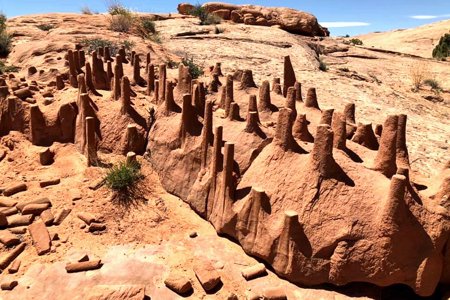
Any idea what made this formation? Q – This is in the Utah desert, south of Green River. I keep hearing that it might be clastic dikes? I have sent this pic to the USGS and they are kinda stumped too but plan to send some paleontologists to check it out. A – The clastic dike explanation looks quite probable. As I understand it, when a fluid (typically water) saturated body of sediment is overlain by another thick layer of sediment the weight of the overlying sediment over-pressures the fluid in the saturated sediment body, resulting in the fluid forcing its way toward the surface, where the pressure is lower, and entraining the accompanying sediment as it rises. Probably looks like a lava lamp, though the processes are distinctly different Comments Any idea what made this formation? — 3 Comments Lloyd DeKay on Dec. 2, 2023 at 2:40 pm said:I suggest the flat tops of these clastic dikes are the result of an impenetrable layer atop the dike-bearing strata, which has subsequently been eroded away.Lloyd DeKay – Webmaster for IAFI Bradai Mohammed on December 2, 2023 at 2:14 pm said: These are called clastic dikes, commonly vertical, they fill open fractures with the help of water, cutting another bed (mud) that’s sitting above, after that it goes through differential erosion, where the soft sediment (mud) gets eroded, and the harder one (sandstone) survive to give you this formation. BRADAI Mohammed El AmineGraphic Designer & Mag. Editor, CEO & Founder of GeoTeach.MePhD student in Stratigraphy-Paleontology, University of Mohamed Ben Ahmed Oran 2, Algeria. Blog: www.geoteachme.blogspot.comInstagram: @the.gneiss.moFacebook: Mohammed BrdYouTube: Explore with Mo Phone: (+213) 798 23 96 50Professional email: Bradai@bk.ru Norman Smyers on July 31, 2020 at 12:18 pm said: My Masters Thesis was clastic dikes of the Panoche Hills (central) California. And yes, the features seen in these photographs from Utah and seen in the recent issue of the Newsletter do look somewhat that they could be associated with clastic dikes. However, I would want to view them up close and personal before saying anything more. For one, the fracture system of the area is a strong clue as to their origins, something difficult to determine with the information at hand. I don’t remember any of my dike structures being evenly truncated at their tops. Obviously at some point in their history there was significant erosion that planed the top of the structure off as well as the surrounding area; and the structures were durable enough to resist subsequent erosion and weathering enough so to persist, as we see them, to present. To make them as durable as they appear to be I would speculate that they were injected from below and into their existing cracks by sediment overlying a fluid rock unit (unconsolidated and wet sediment). Norman Smyers3
Ice In Puget Valley

ice in puget valley Q – My daughter and family live west of Dean Kreger Rd, above Silver Lake, west of Eatonville. I tease her that her yard is gravel held together with a little sand. I believe they are close to the margin of an ice sheet but, I can’t find a map showing the margins. I’ve always been curious when I see different geology features and after watching all of Nick Zentner’s videos I’ve learned enough to be a hazard to myself and society. A – Google Search “Ice in Puget Valley”, “Vashon ice lobe”, “Glacial landforms of Puget Valley” and you will get more than you likely want! WA-DNR – Washington’s Glacial Geology WA-DNR – Glacial Landforms of the Puget Lowland Ice Thickness In Puget Sound
Height of Dry Falls
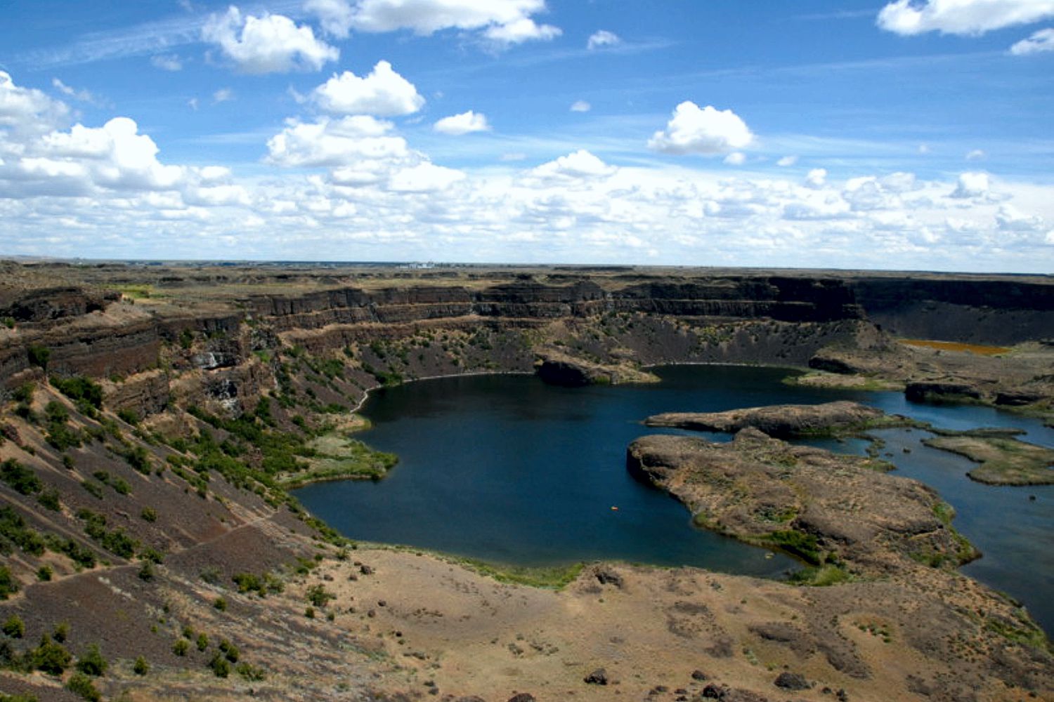
height of dry falls Q – I am a long time resident and have been to Dry Falls several times. Can you please tell me the elevation change between the top of the falls to the lake below ? Do you know or can you direct me to the information? Thank You! A – The height is often cited as 400′ but it appears to be a bit over 500′ based on USGS topographic maps.