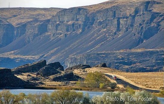
Rounded Boulders Spokane
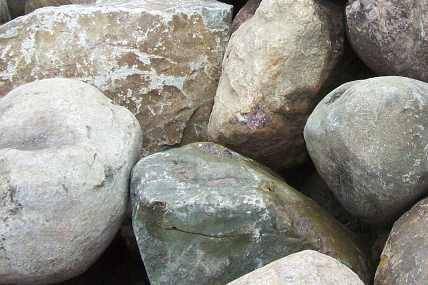
Rounded Boulders in Spokane Ice Rafted Erratics? Q – I have noticed places around Spokane where there are large accumulations of similarly-size boulders. They are smooth and generally about a meter in diameter.. The type of stone varies, but none are Columbia Basin basalt. I assume these are ice-rafted erratics. My question is how did so many end up in a few locations and why are they all similarly sized? My guess is that the flood waters ran into a slope and became still enough to drop similarly-sized loads. Is that right? Or is there another explanation? The South Hill Park and Ride has 81 scattered around the site, some of which I assume were pushed out of the way for paving. Another site nearby has perhaps 40 used for a retaining wall. The Spokane Valley YMCA has a lot, as does the parking lot for the Dishman Hills Natural Area. There are also places along Trent Avenue where these stones are found. Thanks for your reply. – James VanderMeer A – Most all of the well-rounded boulders that clutter parts of the floor of the Spokane Valley are, indeed, derived from the Ice Age floods, but are probably were not ice-rafted to their present locations. They were moved by the tremendous power just downstream from the initial Ice Dam failure, rolled or bounced along the bottom of Glacial Lake Columbia and accumulated rapidly in the deeper parts of the lake. The power of the flood currents dissipated as the waters moved west. Most of the large boulders found father west were probably ice-rafted. The source for these boulders was most likely glacial moraine and stream sediments from Idaho, Montana, and Canada, thus no local basalt in the mix. Because they were “current” derived, they are often sorted in size, and derive from a source where there has been much erosion already and well rounded. More information on this can be had in the online Zoom lecture “What Happened When the Dam Burst” by the IAFI on November 24 by Michael Hamilton.
Spokane Haystack Rocks
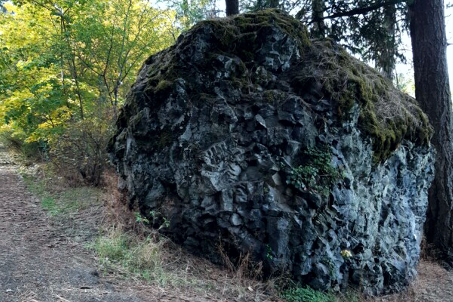
What are Spokane’s Haystack Basalt Mounds? Q – Throughout the Spokane area there are what some call ‘haystacks’, basalt mounds that look like haystacks. There are many such on Spokane’s south hill and I’m including a photo of one that’s in lower Lincoln Park. How did these form? Do they indicate the location of a volcanic vent? – John Ludders A1 – The picture is a large chunk of chill zone basalt. The sequence is chill zone, columnar basalt, entablature, capped by chill zone of the next flow. Like the columns, the chill zone is resistant to plucking but is weak and susceptible to hammering and chipping from rocks in the flow. Many are huge but are basically made in place by chipping, not being carried by flow. – Jim Shelden A2 – The basalt boulder appears to be a portion of the entablature portion of the basalt flow. This portion of the flow commonly worked on by the floodwaters is undercut and portions fall off and get rolled downstream. I have noted hundreds of these boulders in the Spokane area below basalt exposures (cliffs) especially along the north hills (north of Spokane River). They are analogous to the basalt boulders that are observed below Dry Falls (along Umatilla Rock-west side) as seen from the Dry Falls visitor center. The only difference is that the Spokane area gets more precipitation allowing ponderosa pines to grow around them. Also I am not aware that the Cordilleran Ice Sheet advanced south enough into the Spokane vicinity so the basalt boulders are not erratics or “haystack rocks” left after glacial melt. – Brent Cunderla
Badger Mountain Landslide
Badger Mountain Landslide Potential? Q – With all the homes being built on and around Badger mountain in the Tri-Cities, is there any danger of landslides, similar to what is happening at Rattlesnake Hills? I’m unfamiliar with the geology there, and I understand that building homes can affect stability, but are there other likely dangers in that area that potential homebuyers/builders should be wary of? A – There have been prehistoric landslides (now stabilized) on Badger Mountain along with the other ridges nearby. These may have occurred following one more of the Ice Age floods >15k years ago. Renewed landsliding is unlikely as long as there is no significant addition of water that could load the slope and/or lubricate weak zones within, or between, basalt flows – leading to instability. Badger Mountain itself is probably safe since there has been little new development on top or on the steeper sides of the mountain. Most of the mountain is now free from future development, thanks to the Friends of Badge Mountain, who have turned most of the mountain into a preserve. (One exception is the group of new Sterling homes built at the west end of the ridge). Other unprotected ridges may not be as lucky. The cluster of new homes built on top of and along the sides of Little (East) Badger Mountain could generate stability problems, especially if excess water used for landscaping is allowed to percolate underground. There are also a number of new roads dug into the steeper north side of the ridge that potentially could undermine and destabilize the slopes above. Adding irrigation water to these slopes will only increase the likelihood of slope failure in the future. – Bruce Bjornstad
Evidence Elsewhere
Evidence Elsewhere of Ice-Age Floods? Q – Is there evidence elsewhere in the world of ice age floods? Intuitively, I would think glaciers dammed other rivers, created lakes and then eventually collapsed? A – Your instincts are correct. The rivers with big ice and big gorges pretty much all had outburst floods on them. The St. Lawrence Seaway is a flood path as is the Strait between Denmark and Norway and the English channel at the Dover Straits. The Altai Mountain Floods in Mongolia were very steep and fast much like Lake Missoula. The latitude where the ice was melting on its own appears to be more susceptible to very large floods. The Tibetan Plateau also had a series of large floods. Geologist Dr. Vic Baker has created an info-graphic comparing the scale of several terrestrial and Martian flood volumes, though not all are ice-age floods.
The Grand Coulee – A Floods Poem
THE GRAND COULEE – A Floods Poem THE GRAND COULEE Older than legends,Younger than mountains,The earth remembersThe Great Inland Sea. And that Sea emptiedIn torrential furyNever imaginedEven in dreams. Down through the canyons,Flood of all riversCarving the couleesTime, time again. Roiled surging waters,Thunder of thunders,Swift toward the oceanReshaping the plain. Gone with the glaciersIs the great Lake Missoula,Gone from remembrance,Like mist in the wind. Yet the story is etchedIn the canyons and couleesLeft for those who imagineTo seek and to find. David Wahl January 4, 2002 Lower Grand Coulee Upper Grand Coulee at Steamboat Rock (left)
First Peoples Ice-Free Corridor Migration to Americas Reexamined
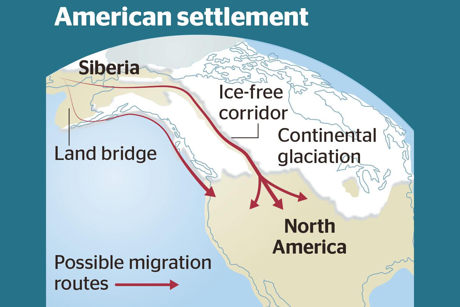
Analysis of how long erratics have been exposed on ice-free ground in the hypothesized “Late Pleistocene ice-free corridor migration route” suggests that route was not fully open until about 13,800 years ago, and the ice sheets “may have been 1,500 to 3,000 feet (455 to 910 m) high in the area where they covered the ice-free corridor,” according to study lead author Jorie Clark, a geologist and archaeologist at Oregon State University. Clark said, “we now have robust evidence that the ice-free corridor was not open and available for the [Late Pleistocene] first peopling of the Americas.” If evidence of humans in the Americas prior to the 30,000 years ago is ultimately found, that evidence does not preclude the possibility of ice-free corridor migration before closure of the corridor.
Waning Pleistocene Ice Sheet Affected Megaflood Paths and Local Shorelines
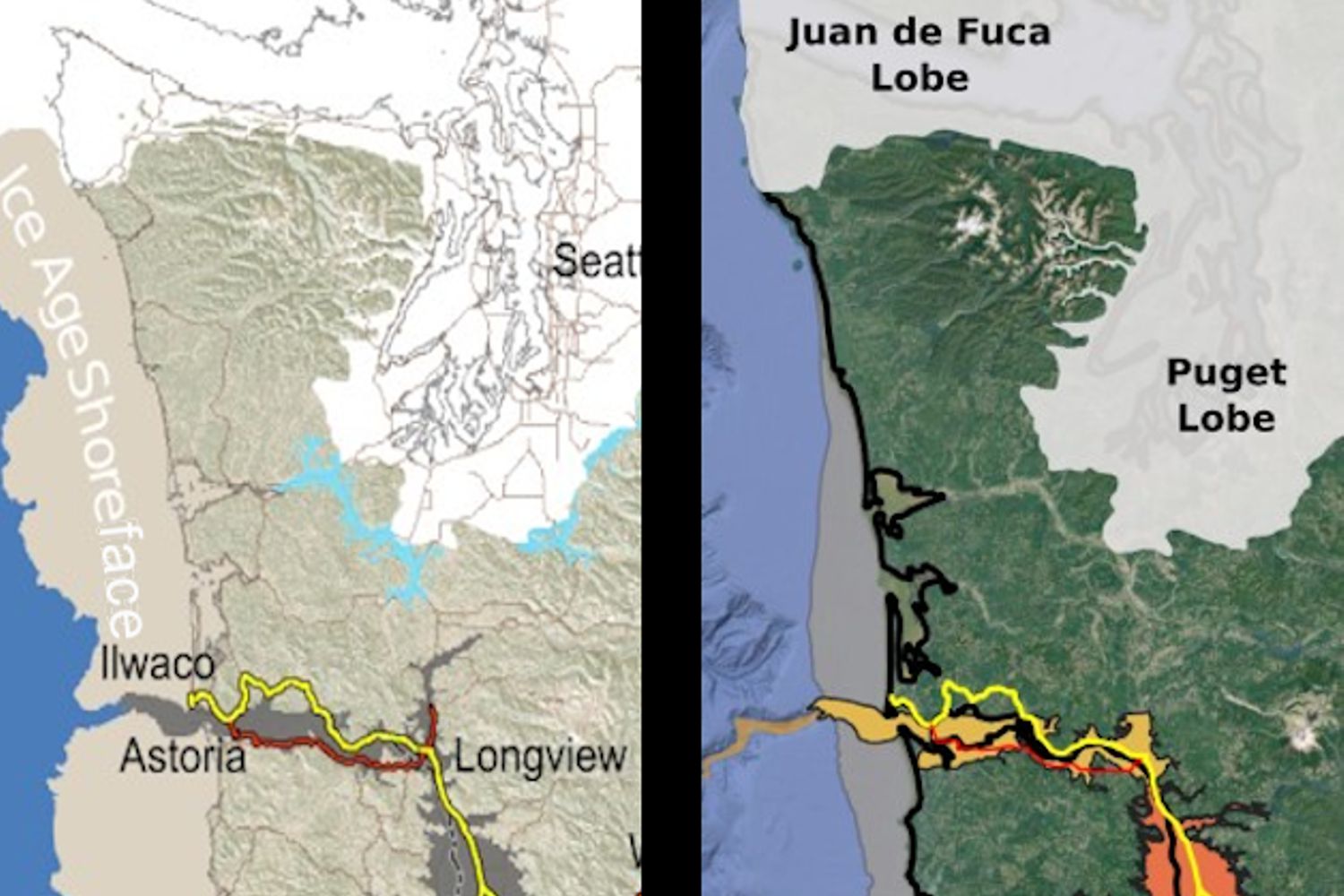
Have you ever thought about the how the weight of the ice-age Cordilleran ice sheet might affect the underlying Earth’s crust. There is strong evidence that the crust was depressed hundreds of feet beneath the ice, and since the crust is relatively thin and rigid over a plastic aesthenosphere, that also caused the crust for some distance beyond the ice margins to tilt toward the ice sheet. A new modeling study explored how changes in topography due to the solid Earth’s response to ice sheet loading and unloading might have influenced successive megaflood routes over the Channeled Scablands between 18 and 15.5 thousand years ago. The modeling found that deformation of Earth’s crust may played an important role in directing the erosion of the Channeled Scabland. Results showed that near 18 thousand year old floods could have traversed and eroded parts of two major Channeled Scabland tracts—Telford-Crab Creek and Cheney-Palouse. However, as the ice-age waned and the ice sheet diminished 15.5 thousand years ago, crustal isostatic rebound may have limited megaflood flow into the Cheney–Palouse tract. This tilt dependent difference in flow between tracts was governed by tilting of the landscape, which also affected the filling and overspill of glacial Lake Columbia directly upstream of the tracts. These results highlight one impact of crustal isostatic adjustment on megaflood routes and landscape evolution. Other studies have shown that relative ice-age sea levels were over 300 feet lower worldwide due to the volume of water locked up in ice sheets. Typical depictions of the shoreface extent are generally based on a 300 ft. depth contour, but there is strong evidence that shorelines were up to 200+ ft. higher than present day in marine areas adjacent to ice sheets, again because the crust was depressed by the weight of the ice sheer. A more accurate representation might show a much narrower shoreface in ice-free areas nearer to the ice sheet margin. However, in the Haida Gwaii Strait at the margin of the ice sheet the lower thickness of the ice sheet meant that local shorelines were as much as 550 feet lower than they are today. This was because the much greater thickness of the center of the ice sheet served to push upwards areas at the edge of the continental shelf in a crustal forebulge. It is now widely thought that these emergent ice-free land areas might have provided a viable coastal migration corridor for early peoples making their way to the Americas from Asia during the Pleistocene.