Fueling Yellowstone’s Supervolcano: A New Tectonic Twist
New research suggests that the Yellowstone supervolcano may not be fueled by a deep “mantle plume” as previously believed. Instead, a study published in Science suggests that the volcano’s activity is driven primarily by tectonic shifts within Earth’s crust. The New “Plumbing” Model For years, scientists debated whether Yellowstone was heated by a deep column of hot rock rising from the Earth’s core. However, researchers using 3D modeling discovered that the magma system is actually controlled by two competing tectonic forces: Crustal Stretching: The lithosphere (outer crust) is being pulled toward the U.S. West Coast. Sinking Plates: An ancient tectonic plate, the Farallon slab, is sinking beneath North America, dragging the lower crust downward. This “tug-of-war” pulls the lithosphere open, allowing magma to migrate from the southwest to the northeast and rise toward the surface. This discovery is a game-changer for volcanic forecasting. By understanding that tectonics—rather than a deep plume—fuel the system, scientists can better predict how the volcano will behave as it moves toward the thicker, colder crust to the east. “Our work changes the understanding of how the magma plumbing system works, so future eruption models have to take this into account.” — Lijun Liu, Geologist at the Chinese Academy of Sciences. This tectonic modeling isn’t just for Yellowstone. It could help researchers better understand other high-hazard systems, such as Toba in Southeast Asia and Taupo in New Zealand, potentially improving volcanic safety worldwide. From an article in LIve Science by Sarah Wild
Missoula Floods Feature – A Site of Mammoth Proportions
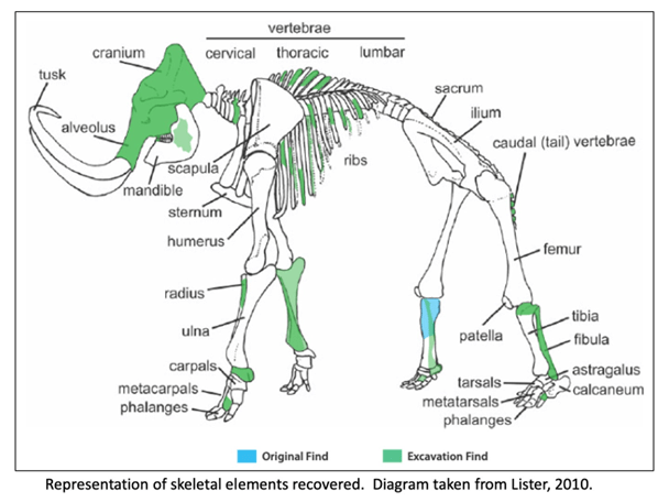
It has been well proven that the Missoula Floods greatly impacted central Washington and there are many examples of the magnitude of the floods, its reach, and dynamics. However, there is still debate on the number, size and timing and dating of these events. What is also less well known are some of the casualties of the floods. At least one feature is helping to tell the story of some of the last floods to grace the landscape. In 2015, a mammoth was discovered at Tonnemaker Hill Farm along the north edge of the Frenchman Hills in Grant County, Washington. Luke Tonnemaker was plowing up an alfalfa field when he made the discovery. Intensive study of the site was led by geologist George Last, paleontologist Bax Barton, local soil scientist and geologist Mark Amara, Gary Kleinknecht, education director, from the MCBONES Research Foundation, a volunteer excavation crew from MCBONES and the Tonnemaker family. The researchers coordinated with farm co-owners, Luke and his father, Kole Tonnemaker, and their wives Amanda and Sonia respectively, to professionally excavate, stabilize retrieved mammoth bones, identify as many bones as possible, and recreate the geology and history of the site. Mammoth remains are not that uncommon in Washington with several hundred animals discovered in the state, though fewer than 100 of those discoveries are located in eastern Washington. What is significant about this mammoth site is that it is one of the few finds that has received this much intensive study. Over 130 bones and bone fragments from a single Columbia mammoth were recovered with about 69 specimens identified. The animal was estimated to be between 25-30 years of age based on characteristics of its dentition, and it even lived with a damaged rib which had healed. George Last prepared diagram The presence of three distinct volcanic ash (tephra) layers and soil analyses suggests that at least four different Missoula flood event episodes are represented in the sediments beneath the mammoth bone bed. Dating of the site revealed that the animal post-dated identified Mount St Helens tephra eruptions that deposited ash in distinct horizons below the bones in water borne deposits. Dates associated with ash samples identified at WSU confirmed two of the layers correspond to Mount St. Helens S series while the topmost tephra shows some compositional variability but had similarities to the J or S series. Tephra ages ranged roughly from 14,000-16.000 years ago. Further dating through Utah State University was provided by optically stimulated luminescence (OSL) samples which gave dates ranging from 16-19,000 years ago. Since the bones are above the highest tephra and OSL sampling sites, the find is definitely younger than 16,000 years ago and was on the edge of one of last Pleistocene Missoula floods slack water lakes to cover this part of Washington. These conclusions were corroborated by analyzing the stratigraphy of the site and describing the soil which confirmed environments of deposition. Since the bones were above the aforementioned tephra layers and OSL sampling locations, and are at the interface of apparent windblown silts and Missoula floods slackwater deposits, it is still unclear how and when the animal died. However, the co-location of the mammoth remains with apparent ice-rafted erratic cobbles and boulders in fine-grained Missoula flood sediments, supports interpretation that the mammoth could have been carried in and left behind by a late breaking Missoula flood. Alternatively, it could have become mired in the mud along the shoreline and/or was killed by predators or even died in a subsequent drier period. Still the intensive studies to date have shown that this is an area with unique geologic history, one that is still unfolding. The Tonnemaker family has the recovered bones on display at their farm store and annually, including 2026, hold tours of the mammoth site during the Othello Sandhill Crane Festival held in March each year. There are a variety of papers, poster presentations and articles published or defended at meetings held by the Northwest Scientific Association and Geological Society of America, and a final report of findings between 2016-2024, with summaries highlighted, is available for viewing at the farm. Article by Mark Amara, Geologist, IAFI Lower Grand Coulee Chapter
A Drone’s Eye View of the Channeled Scablands
Without aerial views of the Ice Age Flood lands, we would still be debating the origins and nature of these features. Satellite and aircraft photos provide a broad overview of the channeled scablands, but in recent years, drones have given us a low-cost tool for close-up aerial photography. The detailed close-up view of the scablands showcases not only the region’s geology but also its incredible beauty. When I first saw Twin Lakes at sunrise, with the ethereal sight of fog rising from the lakes, I realized drones can help bring the scablands to the public. The dry cataracts at Potholes Coulee are another stunning feature not visible from the Ancient Lakes Trailhead but accessible by small aircraft. The trailhead is a popular starting point for exploring the coulee, with a rugged trail leading to the remnant cataracts that overlook the Columbia River. When the drone turned around and the dry falls came into view, I was awed by the cliffs towering over Babcock Bench. The photos tell a story of raging floods and giant waterfalls that have been silent for thousands of years. Lakeview Ranch (North of Odessa, WA) tells another story. The floodwaters flowing down Lake Creek Coulee spread out in this area, carving a random, chaotic landscape as they entered Crab Creek near Odessa. Bob’s Lakes, central to this area of chaos, are a central feature of this terrain, and the surrounding buttes and cliffs stand as a testament to the flood. A short distance to the northeast of Lakeview Ranch (on state road 21) is an excellent collection of structures called kolks, also called potholes. These are circular depressions drilled out by vortices in the flood waters and are not obvious from the road. All of these channeled scabland features are paradoxically difficult to see from ground level! The first time I flew a drone over Coffeepot Lake, part of the Lake Creek coulee system, the flood channels feeding into the lake became immediately obvious! Another paradox is that extremely high-altitude photos, such as those from satellites or high-altitude aircraft, make finer landscape features less obvious or even invisible. Low-flying aircraft, such as helicopters, are a possibility, but are costly to operate. Drones strike the middle ground with affordability and reasonable photographic scale. Unmanned aircraft have been flying since World War II, but with the mass production of powerful batteries, motors, and microprocessors, the aircraft’s reliability, size, and cost have become accessible to the average person. More Details About Drones Drones put high-quality flying cameras in the hands of geologists and others interested in geology. A drone, also known as an Unmanned Aerial Vehicle (UAV), is controlled by a pilot on the ground using a radio control system. The drone uses a high-quality camera to take images. So what can all of this fancy technology do? Many things! Search and rescue, mapping, power line inspections, and motion pictures are common uses for UAVs. They provide access to geologic features that are inaccessible or too dangerous for direct inspection. This access is a huge win for people studying the Ice Age Floods! A drone can photograph a coulee from its bottom to the top of the canyon rim. It can also reveal ripple marks left behind by the flood waters; marks that are invisible at ground level! Using the drone as a video camera enables real-time flight down a flood channel, giving viewers a sense of the flood. The price of these flying cameras has dropped significantly over the years. An inexpensive beginner drone with a quality camera starts at under $400. It is also under the FAA (Federal Aviation Administration) limit of 249 grams, so it doesn’t require registration. If the drone exceeds the 249-gram limit, a license fee is required, and the drone must display the registration number obtained during registration. Additionally, if you intend to use the drone for commercial work, you’ll need a UAV pilot’s license, also known as a Part 107 license. With a 107 license, a drone pilot is free to publish or donate photos as he or she wishes. Article and images by Bill Clugston and his drones. If you want to learn more about drone photography Bill agreed you can contact him directly at bclugston1@gmail.com https://youtu.be/HGgZ-lF5Gjk
About Volcanoes
View a gallery of diagrams for different volcano types, with glossaries The three major types of volcanoes—cinder cone, composite, and shield—each exhibit unique, lesser-known subterranean and surface features, including lava bombs, lahars, and spatter. Other types of volcanoes include lava domes, calderas, fissure volcanoes, and Maars and tuff rings. Even if you don’t live near a volcano, you’ve been impacted by their activity. It’s estimated that more than 80% of our planet’s surface has been shaped by volcanic activity. They’ve helped create our mountain ranges, plains, and plateaus, and have even helped fertilize the land that we now use to grow crops. These critical mounds come in many shapes and sizes. This graphic by Giulia De Amicis provides a brief introduction to volcanoes, explaining their different types of shapes and eruptions. The Four Main Types of Volcanoes Volcanoes vary in size and structure, depending on how they’re formed. Most volcanoes types fall into four main groups: Shield Volcanoes – Shield volcanoes are built slowly, from low-viscosity lava that spreads far and quick. The lava eventually dries to form a thin, wide sheet, and after repeated eruptions, a mount starts to form. From the top, these types of volcanoes look like a shield, hence the name. While these volcanoes take a while to form, they aren’t necessarily low. In fact, the world’s tallest active volcano, Mauna Kea in Hawaii, is a shield volcano. Stratovolcanoes – Also known as composite volcanoes, stratovolcanoes are built relatively fast, at least compared to shield volcanoes. This is because, in between lava eruptions, composite volcanoes emit ash and rock, which helps add structure to the mound rather quickly. Some well-known composite volcanoes are Mount Fuji in Japan, Mount St. Helens in Washington, and Mount Cotopaxi in Ecuador. Volcanic Domes – Opposite to shield volcanoes, volcanic domes are formed when lava is highly-viscous. Because the thick lava can’t travel very far, it starts to pool around the volcano’s vent.This can sometimes create a pressure build-up, meaning dome volcanoes are prone to explosive eruptions. Cinder Cones – These types of volcanoes typically don’t release lava. Rather, their eruptions typically emit volcanic ash and rocks, known as pyroclastic products. Cinder cones are characterized by a bowl-shaped crater at the top, and usually don’t exceed 400 m (1,312 ft) in height. Lava flow viscosity plays a significant role in the type of volcano formed Magma usually stays underground because of a balance between its upward pressure, the weight of the Earth’s crust above, and the crust’s rock strength. Landslides can reduce crust weight, while built-up gas pressure can strengthen magmastatic pressure.Thin, runny flows spread quickly before cooling, producing expansive layers that build over time into wide shield volcanoes. The ejection and fast hardening of thicker lava flows and pyroclastic material create steep slopes and the characteristic cone shape of composite volcanoes. Explosive volcanic eruptions happen when magma pressure overcomes rock strength The composition of magma affects the explosivity of volcanic eruptions. Silicate-rich magma contains extensive molecular chains that trap dissolved gases like water and carbon dioxide. These gases build pressure until they violently escape, creating explosive eruptions. Low-silica magmas produce gentler eruptions categorized as effusive. Magma usually stays underground because of a balance between its upward pressure, the weight of the Earth’s crust above, and the crust’s rock strength. Landslides can reduce crust weight, while built-up gas pressure can strengthen magmastatic pressure. https://youtu.be/LQwZwKS9RPs?si=U9p1nxKIRjASDi12
Stunning Fossil Site Reveals Life Rebounding After Major Extinction Event

Just over half a billion years ago, Earth was rocked by a global mass extinction event, a dramatic interruption of the Cambrian explosion of life on Earth. It wiped out an estimated 50% to over 90% of animal species, particularly in marine environments. What happened next, in the direct aftermath of this event, has mostly been a mystery – until now. A newly discovered fossil site in Hunan, South China, has captured an entire ecosystem in recovery, in extraordinary detail, including soft tissues and internal structures. Nearly 60 percent of the species found within are previously unknown to science. Named the Huayuan biota, the collection boasts 153 animal species spanning 16 major groups, for a grand total of 8,681 fossil specimens recovered from a single site – and it was all recorded around 512 million years ago, hot on the heels of the Sinsk extinction around 513.5 million years ago. The richness of species and level of preservation rivals Canada’s famous Burgess Shale. Earth’s Cambrian Period, which lasted from around 540 to 485 million years ago, was a time of great change for our planet. It was during this time that the first major diversification of animal life took place – the Cambrian explosion. But the tree of life was trimmed shortly after with the Sinsk extinction event, which may have been triggered by tectonic activity. Thanks to a handful of BST Lagerstätten from around the Sinsk event, paleontologists have managed to reconstruct some of the effects it had on life on Earth. The Burgess Shale in the Canadian rockies is about 508 million years old; the Qingjiang biota and the Chengjiang biota, both in China, are about 518 million years old. These sites helped scientists discover that, while many shallow-water species were killed off in the Sinsk event, life managed to rebound within a few million years. Dated to around 513 million years old, the Huayuan biota is a direct window into the immediate aftermath of the extinction event. It shows that at least some ecosystems – namely, deeper waters – served as safe refuges. The fossils themselves reveal a rich and diverse ecosystem, filled with predators and prey alike. Their preservation includes far more than just their external shapes and textures – in many cases, internal organs and soft tissues were captured in exquisite detail, including nervous systems and even cellular structures. Other structures preserved include gut diverticula and optic neuropils, offering rare glimpses into ancient digestive systems and nervous tissue. The site will keep scientists busy for many years to come. Earth has quite a few tricks up its sleeve for fossilization, but the Huayuan biota is truly a shining rarity. It belongs to an elite class of fossil deposits known as Lagerstätten – fossil beds that have both exceptional richness and exceptional preservation. But it’s not just any Lagerstätte; a team led by paleontologist Maoyan Zhu of the Chinese Academy of Sciences has classified the Huayuan biota as a Burgess Shale-type (BST) Lagerstätte – the very rarest and finest type of fossil bed, where soft-bodied animals and delicate internal tissues are preserved as a rule, not an exception. The biota contains arthropods such as trilobites and apex-predator radiodonts, and invertebrates like sponges, comb jellies, and sea anemones. What makes this special is that many of these animals appear to have been preserved where they lived, rather than being swept in from elsewhere. This means that researchers can make inferences about their behavior; for example, a number of vetulicolians were preserved in groups, suggesting that they shoaled together in life. Perhaps the most surprising discovery is that of the world’s oldest known pelagic tunicate, a group of filter feeders that today play a major role in the ocean’s carbon cycle. The presence of free-swimming tunicates in the biota suggests that surprisingly modern-style ocean ecosystems were already taking shape soon after the Sinsk extinction. The other really exciting part is that the researchers compared their biota with other Cambrian Lagerstätten. They found that the Huayuan biota bears some striking similarities to the Burgess Shale fossil site. Several iconic animals once thought to be unique to the Burgess Shale, such as Helmetia and Surusicaris, appear in the Huayuan assemblage as well, even though the two sites are separated by thousands of kilometers and millions of years. It’s an absolutely magnificent find, and one that’s likely going to become crucial for understanding the Cambrian Earth. “The extraordinary biodiversity of the Huayuan biota provides a unique window into the Sinsk event by revealing the post-extinction recovery or radiation in the outer shelf environment,” the researchers write. “It indicates that the deep-water environment might have played a crucial role for structuring the global marine animal diversification and distribution since the early Cambrian.” The research has been published in Nature. This article is taken from a Science Alert article by Michelle Starr
Telling the Story of the Missoula Floods
Developing an Ice Age Floods Animation Through Science, Partnership, and Interpretation Explaining the Missoula Floods has never been simple. The floods reshaped landscapes across much of the Pacific Northwest, yet they occurred thousands of years ago, unfolded repeatedly rather than once, and operated on a scale that is difficult to grasp from any single viewpoint. While physical evidence of flooding is visible in coulees, erratics, and sediment deposits across the region, understanding how those features formed requires connecting processes that span vast distances and long periods of time. For the Ice Age Floods National Geologic Trail, this challenge sits at the center of its mission. The Trail links flood-related sites across four states and relies on partnerships with parks, museums, educational institutions, Tribes, and communities to interpret a story that is regional in scale and national in significance. Developing a shared, accurate way to tell that story has been a long-standing goal. One important step toward that goal is the release of a new Ice Age Floods animation, now publicly available through the Pleistocene Post for the first time ever through the National Park Service and the Ice Age Floods Institute. Understanding the Missoula Floods—and Why Animation Was Essential The Missoula Floods were not a single catastrophic event. They occurred dozens of times as an ice dam repeatedly formed and failed during the last ice age. Each flood released immense volumes of water, carving the Channeled Scablands, transporting massive boulders, and depositing thick layers of sediment across the Columbia Basin, the Willamette Valley, and beyond. These repeated events reshaped landscapes on a scale that is difficult to grasp from any single location or landform. This combination of repetition, scale, and process presents a fundamental interpretive challenge. Static maps, photographs, or diagrams can show where flooding occurred, but they struggle to convey where ice dams formed and failed, why floods happened repeatedly, and how those repeated events shaped the landforms we see today. Visitors often encounter individual features—such as coulees, erratics, or sediment deposits—without an intuitive sense of how those features connect to a larger, system-wide story. Animation offers a way to bridge that gap by showing movement, change, and sequence over time. It makes it possible to illustrate how ice dams failed, how floodwaters moved across vast landscapes, and how erosion, transport, and deposition shaped the region over thousands of years. By showing sequence and scale together, the animation provides context that static interpretation often cannot. At the same time, animation carries risks. Visual storytelling can unintentionally oversimplify complex processes or imply certainty where scientific understanding includes ranges and ongoing inquiry. Addressing those risks required careful collaboration and review to ensure the final product communicates current scientific understanding clearly, accurately, and responsibly. A Trail Built on Partnership The Ice Age Floods National Geologic Trail is a partnership-based unit of the National Park Service. Unlike traditional national parks, the Trail does not center on a single land base. Instead, it connects a network of sites, organizations, and communities that collectively interpret the Missoula Floods story across four states. From its earliest days, scientific research and public education about the floods have been advanced by regional partners, particularly the Ice Age Floods Institute, along with academic researchers, museums, educators, and land managers. Federal agencies with expertise in geology, hydrology, and landscape science have also contributed to the evolving understanding of flood processes and landforms. Together, these partners built the scientific foundation and public awareness that ultimately made the Trail possible. That shared foundation shaped how the Ice Age Floods animation was conceived. The project was not approached as a standalone National Park Service product, but as a collaborative effort intended to reflect current scientific understanding while respecting decades of research, publication, and public engagement. Partner involvement helped ensure the animation was grounded in credible science and responsive to the needs of educators, interpreters, and institutions working across the region. Just as important, partners helped shape how the animation would be used. From the outset, it was understood that no single product could replace place-based interpretation. Instead, the animation needed to complement local stories, support diverse interpretive goals, and function as a shared framework rather than a prescriptive narrative. The result is an animation designed to be flexible, modular, and broadly applicable. A Collaborative Development Process Developing the animation was an iterative process involving scientists, interpreters, educators, and media specialists. Expertise in glacial dynamics, flood hydraulics, geomorphology, and interpretation informed each stage of development, ensuring that both scientific rigor and interpretive clarity remained central throughout the project. Drafts were reviewed not only for technical accuracy, but for how audiences might reasonably interpret what they were seeing. Revisions focused on clarity and defensibility—refining pacing so that scale was conveyed without exaggerating velocity, ensuring viewers could distinguish between process and outcome, and reinforcing that the floods occurred repeatedly rather than as a single event. In many cases, refinements were not about correcting facts, but about improving how those facts were communicated visually. The goal was not to resolve every scientific nuance, but to present a version of the story that is accurate, carefully framed, and useful across many interpretive settings. This collaborative approach helped ensure the animation could serve as a reliable interpretive tool while remaining accessible to broad public audiences. What the Animation Is—and Is Not The Ice Age Floods animation is intended to provide a system-scale overview of how the floods worked, support education and interpretation across diverse settings, and serve as a shared visual reference for partners and educators. It is not intended to replace place-based interpretation, resolve all scientific debates, or function as a comprehensive instructional resource on its own. In many cases, individual segments of the animation may be more useful than the full piece. Short sections can illustrate specific topics—such as basalt erosion, flow through constricted valleys, or the cumulative effects of repeated flooding—while local interpreters focus on the features and stories most relevant to their sites. Supporting Education and Public Understanding Now that the animation is publicly available, it
The Pulse of Rocks

“All creatures, objects, places, and elements have a spirit.” Patrick Saltonstall, Sugpiag (Aleut) Are rocks alive? Hmm. You might be visualizing a small stone or large boulder just sitting there…doing nothing. If life has to originate from a cell, then a no vote seems reasonable. Let’s give the Mineral Kingdom a few minutes to speak on behalf of its constituents: “Our rocky friends react to temperature, expand and contract; they can absorb moisture, and they can transform their makeup entirely, like petrified wood changing into stone. Taxonomy – In the 19th . century, rocks and minerals were first classified based on their chemical make-up. As with animals and plants, new members are added yearly to the mineral kingdom’s nearly 10,000 species. Movement – Rocks sure move around, from riding glacier waves, to being catapulted for miles out of fiery volcanoes to being gently tumbled downstream by…streams, and through time, broken down into sandy beaches. Or, if you’re pumice, you can simply float downstream at your leisure. Any pebble has placed many travel stickers on its luggage finding itself in many lands during its long life. Stalagmites and stalactites check off another life form requisite by respectively growing up and down in caves with the help of slowly dripping water. Rock serves us well in concrete, road building materials, sculptures, and stone homes, all making us Salt of the Earth. Reproduction and Growth – Kidney stones are minerals and salts formed in urine. They form and grow in the bladder and kidneys. The imbalance of too many minerals in the urine and not enough liquid causes the minerals to reproduce and grow. Cooperation – Practically all living things rise out of soil, which is a mixture of organic and inorganic magic. Plants need both. Animals need minerals too. Salty seas cover a major chunk of our planet providing a swimming pool habitat to countless known and still to be known species Awe Inspiring – Rocks are the basis for our most beloved national, natural treasures, from the timeless Grand Canyon, to Yosemite’s granite walls, towering Mt. Rainier, the sandstone Arches, and the Grand Tetons, among many others. We are moved to witness sunrise and sunset light beaming red, and filtered white on mountain peaks. We climb boulders; we summit mighty bare rock and snow-covered mountains for the view, for the peace, perhaps for the love, too. The Fine Line – Everything that is living on our precious planet originated with and within the rocky world, making it a challenge to separate the line between non-life and existence. We are made of stars. We are made of star spirit. A wildlife biologist/naturalist reflects on lithologic ‘life’, Bill Weiler, January 2026
Why Are Basalt Columns Mostly Hexagonal “Bestagons”
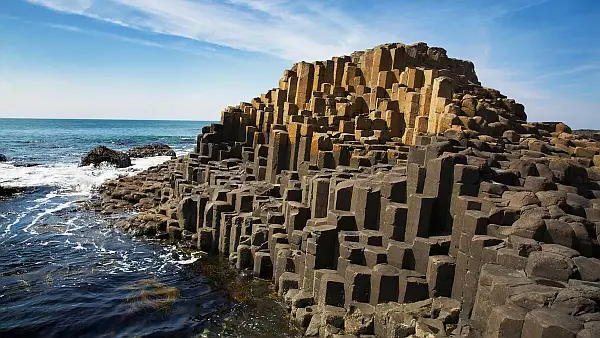
The Giant’s Causeway is a rock formation that is so otherworldly that it seems like it was made by supernatural beings. But these incredible hexagonal columns of rock aren’t the result of giant masons. They formed through a quirk of volcanic activity that shows that hexagons really are the bestagons! Cooling lava naturally creates hexagonal cracks to evenly relieve stress When lava cools and turns into rock, it contracts and builds up tension, particularly when held in place by the surrounding landscape. Just as drying mud cracks, initial cracks in the rock are random, but quickly organize into a hexagonal pattern, which scientists consider the most space-efficient shape. Note: the presentation talks about lava cooling from the top down, but it also cools upward from the bottom where it flowed onto a cooler land surface. In our area we typically see columns underlying a more chaotically fractured “entablature”. It is generally thought that because the entablature section is exposed to the air and precipitation, that results in rapid cooling that produces chaotic fracturing. The columnar section which is cooling upward from the base, would experience a much slower and more even rate of cooling, allowing it to better organize into an optimal, space-efficient “bestagonal” shape. Found via SciShow, hosted by: Niba @NotesbyNiba
There IS such a thing as ‘settled science’

How bad-faith arguments sow doubt by weaponizing scientific humility Good advice to consider when either claiming or questioning scientific (and geologic) theories and hypotheses “Science is never settled” has become a go-to slogan for populists seeking to legitimize fringe scientific positions. In 2020, Representative Nancy Mace was asked whether she agreed that climate change is the result of humanmade greenhouse emissions. She responded: “My opponent has said that the science is settled on this. Well, the science is never settled. Scientists will tell you that.” In February, Senator Roger Marshall argued more money should be spent on investigating widely debunked links between autism and vaccines, saying “I’m a physician. Science is never settled. That’s what makes us scientists.” When U.K. Reform party leader Nigel Farage was pressed on whether he would “side with medical experts who say ‘a link between Tylenol use in pregnancy and autism’ is dangerous nonsense,” he responded, “When it comes to science, I don’t side with anybody… because science is never settled.” The issue is, of course, that in many areas, from the theory of evolution to the theory of gravity, science is very much settled. To pretend otherwise is to misrepresent the position of the scientific community. That doesn’t mean that scientific positions are eternally fixed and can’t be updated in light of new evidence. It means that our current best explanations have been tested enough for us to be confident that they are good descriptions of the way things work. Myth of overturned consensus A favorite trope of climate denialists is that scientists in the 1970s predicted “global cooling” — an imminent ice age. It’s a smart argument, because if you can suggest that the exact opposite of global warming was once the prevailing view, surely you throw the current consensus on climate science into doubt? Despite media attention and much discussion of the idea, global cooling was never a consensus scientific position. Reviews of the literature at the time show that even 50 years ago, global warming dominated scientific thinking about the Earth’s short-term climate future. That climate change is the result of greenhouse gas emissions is now very much the consensus scientific position. There are, however, examples in science where consensus positions have been modified or updated. Gravity is a classic case. Galileo established that acceleration due to gravity is the same for all objects near Earth’s surface. But it wasn’t until Newton that we had a universal theory of gravitation. Newton’s theory unified the behavior of objects falling on earth with the motions of planets. For years, every measurement seemed to confirm it, and the theory became known as a “law” that nature was thought to obey without exception. But as experiments expanded and instruments improved, the edges of Newton’s “law” began to fray. When dealing with strong gravitational fields like those near a black hole, or when calculating to high precision or over short astronomical distances, Newton’s law wasn’t sufficient. In the 20th century, Einstein’s general relativity filled many gaps — resolving a range of seeming astronomical anomalies and describing how light bends near a black hole. Yet even the relativistic interpretation of gravity is not perfect. We know, for example, that it must break down inside a black hole. First Galileo’s and then Newton’s theories were superseded, and we know Einstein’s isn’t correct in every situation. Does that mean these earlier theories are useless and not examples of settled science? Definitely not. In contexts where these theories have been rigorously tested and shown to give the correct answers (to a given degree of precision), they remain valid. They aren’t wrong — just special cases of the more general theories, valid within a given domain of legitimacy in which they were originally postulated and tested. In the same way, whatever supersedes Einstein’s theory will have to include it as a special case. The example of gravity shows that scientific knowledge can evolve yet still be considered settled within its domain of legitimacy. We can point to other consensuses, like evolution or germ theory, as settled science that has been expanded and generalized over time. Scientific ‘facts’ There are also questions that most would call definitively settled. That Earth is round, not flat, is perhaps the most obvious. But whether we choose to call this a “fact” or not depends on how we define the word. If we demand 100% certainty, science can’t provide it. If you want certainty, you need to look to mathematics, where knowledge is built through deduction from axioms (a fundamental set of premises), independent of the world. Science, in contrast, built on evidence and induction, can only ever offer increasing confidence. A key premise of the scientific method is openness to new evidence. If you consider yourself 100% certain, then no new evidence, however convincing, can change your mind. That is not good science. However, if you accept that science provides evidence for hypotheses, it can offer what we might call indisputable evidence — so robust that disputing it isn’t a tenable position. Overturning the not-flat worldview would require such a massive reconsideration of what we understand about reality as to make it practically impossible. So, “settled science” does not mean we know something with absolute certainty, but that the weight of evidence is heavily in favor of this interpretation. Perhaps more importantly, if someone wants to change the currently held conception, the burden of proof is on them. All scientific knowledge comes with uncertainty. That is the hallmark of good science. But uncertainty doesn’t mean we cannot confidently assert that entropy always increases (the second law of thermodynamics) or that Earth orbits the sun. Science embraces uncertainty and is open to revision when new information appears, but that does not mean we shouldn’t take a position when the evidence stacks up on one side of the balance. Issues that have been rigorously tested can still be considered settled. Not being 100% certain isn’t the same as being 50-50. Admitting doubt isn’t the same as both-siding a one-sided issue. The fact that scientists acknowledge uncertainty isn’t a reason for championing false balance. But these are the fallacious positions populists are taking when
The first people in the Americas
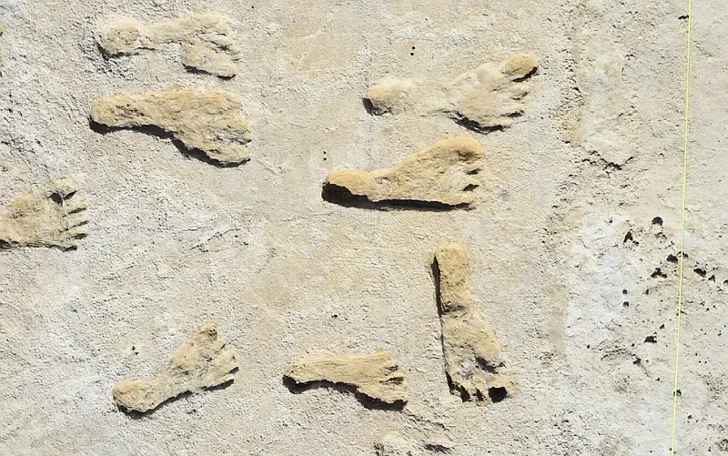
The first people to arrive in the Western Hemisphere were Indigenous Americans, who were descended from an ancestral group of Ancient North Siberians and East Asians. They likely traveled along the Bering Land Bridge by land or sea. When the first Americans arrived is a source of ongoing debate. Several studies suggest that a series of fossilized human footprints found at White Sands National Park in New Mexico date to sometime between 21,000 and 23,000 years ago. That dates them to the coldest part of the last ice age, the last glacial maximum (which lasted from around 26,500 to 19,000 years ago), when the northern part of the continent was covered in glaciers and ice sheets. Other controversial studies suggest even earlier dates. For example, dated stone artifacts in Chiquihuite Cave, in Mexico, to more than 30,000 years ago. However, it’s unclear if humans actually crafted these rocks or if they formed naturally that way, making the finding uncertain. Other studies go back much further. In 2017, a controversial study in the journal Nature reported mastodon bones in California that may have been modified by humans around 130,000 years ago. However, other archaeologists have expressed concerns about the excavation of this finding and noted that other natural events or animals could have modified the bones. To put the 130,000-year-old date into context, the earliest evidence for Homo sapiens dates to around 300,000 years ago in Morocco, while the earliest evidence for a successful migration of humans into Asia was more than 100,000 years ago and the earliest evidence of successful human migration into Europe was around 55,000 years ago. Excerpted from Who discovered America? By Owen Jarus in LiveScience