Bretz and His Floods Story – National Geographic
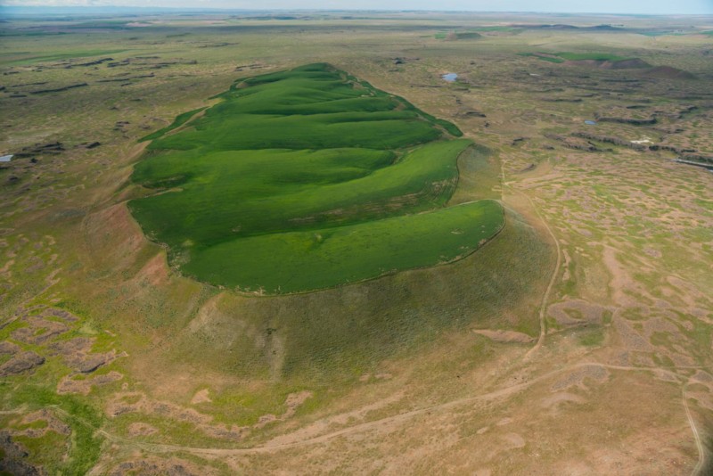
National Geographic has published an outstanding article, “Formed by Megafloods, This Place Fooled Scientists for Decades”, about J Harlan Bretz and his outrageous, fantastical theories of a landscape shaped by huge floods. Most Ice Age Floods aficionados are generally aware of the story, but this one is so detailed and well written it’s worth reading for the story-telling value alone. Please see: This National Geographic site:
Beryllium-10 dating of late Pleistocene megafloods and Cordilleran Ice Sheet retreat
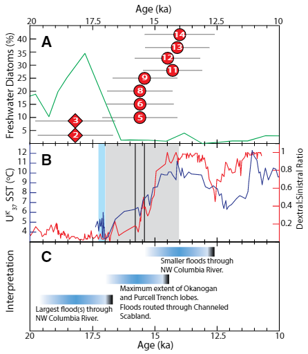
Balbas et. al. use cosmogenic beryllium-10 dating methods to further constrain the timing of ice sheet retreat, as well as the potential pathways for megafloods from both Lake Missoula and Lake Columbia. Read this fascinating Geology article summarizing their findings. Balbas2017 – Missoula Flood Chronology In summary, our new chronological information suggests the following: (1) Blockage of the Clark Fork river by the Purcell Trench lobe by ca. 18.2 ka, resulting in Missoula floods following the Columbia River valley. (2) Blockage of the Columbia River valley by the Okanogan lobe before 15.4 ± 1.4 ka, which shunted Missoula flood water south across the Channeled Scablands. (3) The final Missoula floods at ca. 14.7 ± 1.2 ka, signaling retreat of the Purcell Trench lobe from the Clark Fork valley, yet these floods entered a glacial Lake Columbia still impounded by the Okanogan lobe. (4) Down-Columbia floods at ca. 14 ka from breakouts of glacial Lake Columbia, signaling the retreat and final damming of the Columbia Valley by the Okanogan lobe
Washington’s Ice Age Floods – ESRI Story Map
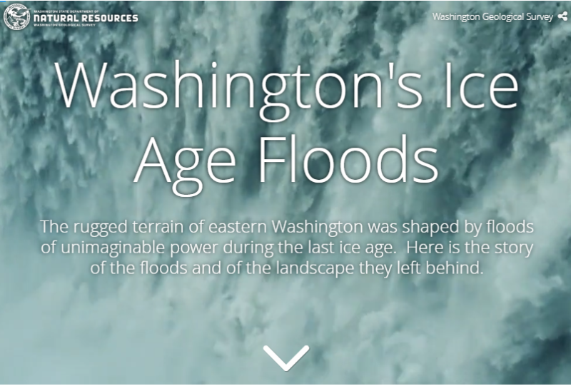
The Washington Geological Survey (formerly the Division of Geology and Earth Resources) has just released an ESRI story map about the Ice Age Floods in Washington. The story map: “tells the story of cataclysmic outburst floods that shaped the landscape of the Pacific Northwest during the last ice age. With imagery, maps and video, this story map follows the devastating deluge of the Missoula floods as it tore across the landscape, from its origins in western Montana to its terminus at the Pacific Ocean. Sites along the Ice Age Floods National Geologic Trail are featured, with an emphasis on flood features in Washington State.” Entitled Washington’s Ice Age Floods, it is best viewed on a desktop or laptop computer. Mobile devices will not show all of the content. It is navigated by scrolling your mouse through the slides. There are a few animated sections that may take a second or two to load. [weaver_iframe src=’https://wadnr.maps.arcgis.com/apps/Cascade/index.html?appid=84ea4016ce124bd9a546c5cbc58f9e29′ height=600 percent=100]
Did humans witness any megafloods?
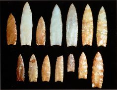
Richard Waitt kindly shared his recent paper published June 2016 in Quaternary Research, titled “Megafloods and Clovis cache at Wenatchee, WA.” “It covers the reach mainly from Chelan Falls to below West Bar, tries to tell the story of sequential megafloods coming to Wenatchee area by different routes at different times, and tries to work in the story of early Homo sapiens in the region, especially as contemplated from the 1988-1990 excavations of the East Wenatchee Clovis cache,” said Waitt in an email to the Wenatchee Valley Erratics. His easy-to-read and immensely interesting paper covers both the geological and the archaeological stories for the Wenatchee area. Did humans witness megafloods? Read the paper Megafloods and Clovis cache at Wenatchee, Washington to find out!
Columbia Basin Plays a Hand in Mars Mission
— By Jill FitzSimmons, editor@qvpr.com, reprinted from Quincy Valley Post Register What possibly could the Columbia Basin and its channeled scablands have in common with the Red Planet, millions of miles away? Turns out, more than you would think. Scientists believe that billions of years ago Mars experienced not only volcanic episodes but also great floods that carved out massive, stark cliffs and ancient bodies of water. Left behind were the Red Planet’s scablands. Sound familiar? Back on earth, millions of years ago the lava that flowed over the Columbia Basin was the first in a series of catastrophic events that came together to shape this area. The lava flowed over vast areas, only to cool and then be carved by massive glacial floods. The Columbia Basin is the only place on the planet that comes close to having the geologic features of those found on Mars, said Melissa Rice, assistant professor of planetary science at Western Washington University. Both the Red Planet and the Columbia River Gorge were formed by catastrophic floods that scoured the landscape, Rice said. “This is the only place in the world where this exact thing has happened,” she said recently from the home of Ken and Susan Lacy that overlooks the dramatic cliffs of Crescent Bar, the Columbia River Gorge and the West Bar’s giant ripples – all signs left behind from the Ice Age floods. Rice was among 30 scientists, engineers and graduate students from around the nation and the globe who visited the area last month on a mission to get a close-up and personal view of the local channeled scablands. Some of those who visited the area are among the world’s top Mars scientists. The two-day visit came as the team prepares to get down to work designing and building a camera system that will be on the next rover mission, to be launched in 2020 and on Mars in 2021. Scheduled to operate on Mars for 10 years, the rover will search for signs of past life on the Red Planet. The team decided to meet up for two days of touring and getting to know one another before heading to a rover-planning meeting in Bellingham. The gathering in Eastern Washington was the closest they could get to the next best thing. “We don’t get to go to Mars,” Rice said. In their trip around the area, the team on its first travel day visited the Ginkgo National Forest near Vantage and the Frenchman Coulee. They went to an overlook near the Potholes Coulee to see the butte-and-basin topography. They even stopped on Trinidad Hill, where, dressed in orange vests, they got out of their cars to feel the Eastern Washington basalt. On Day Two, they were headed to Dry Falls and the Moses Coulee. At the Lacy home, several members of the team walked out the couple’s back door and gasped as they took in the view of the river and its gorge. Jeff Jones, planetary geologist at John Hopkins University’s Applied Physics Laboratory, described the area as a “great geologic experience.” Dr. Kjarton Kinch of the University of Copenhagen in Denmark, the world’s expert on Martian dust, was excited to hear the flood stories from Ken Lacy. Kinch called the local scenery “spectacular.” The rover the team is helping to design will be the fifth to be sent to Mars. In past missions, the rovers have had unique objectives, such as searching for signs of habitability or evidence of water on Mars. “This is the first mission actively searching for signs of past life,” Rice said. Scientists are searching for “bio-signatures,” or pieces of evidence that may exist in the rock record on Mars, Rice said. While the bio-signatures could exist in many forms, such as a dinosaur bone sticking out of the ground, scientists likely are looking for concentrations of organic molecules, the building blocks of life, preserved in the rock, Rice said. Rice and her team are designing and building the instruments that will be used to search for those bio-signatures. The instruments will be installed on a long, skinny neck, called a mast, at the front of the rover. The cameras will serve as the eyes of the rover, Rice said. After leaving Eastern Washington, the scientists were headed to a “community meeting” of scientists that were to narrow down the landing sites for the 2020 rover. Thirty potential sites were narrowed to eight. Those eight will be taken down to four in January, and the camera team will discuss which of those sites it wants to support, Rice said. “We only get to drive around 10 kilometers, so the landing site is important,” Rice said. Ken Lacy, a board member of the Ice Age Flood Institute, said that by inviting the group into his home and hosting a barbecue he was hoping to share a piece of the area and its geologic history with the Mars scientists. It’s an exciting mission, he said, and he and his wife were happy to host the group. “And maybe, in some small way, it helps,” he said.
Top Scientists Gather to Discuss Mars Exploration
By Tim Johnson · Wednesday, June 22, 2016 – Reprinted from CascadiaWeekly.com Life. Are we unique? Are we alone? These are time-honored questions, and the answers may be approaching. Our best candidate for exploration is one of our nearest neighbors, Mars, a small, cold desert world that might have had a vibrant and watery past. The surface of Mars is currently being explored by robots, some long past their expected engineered lives. Each has advanced scientific understanding of the surface of Mars. Soon they’ll be joined by another, designed to advance the discoveries made by other devices and instruments and tuned to a specific mission: The search for signs of life, past or present, on the Red Planet. Some of the world’s top Mars scientists will gather in Bellingham to share the latest scientific results from Mars exploration and preview NASA’s next-generation Mars rover mission. While they’re here, they’ll also visit the extensive lava flows in the eastern portion of the state, a model for the types of geological features and terrain that might be expected on Mars. The group includes Jim Bell, the lead scientist on the next-generation camera system that will fly on NASA’s next Mars rover, which is scheduled to launch in 2020. Working on that device is Western Washington University’s Melissa Rice, assistant professor of Geology and member of three NASA Mars rover missions, will engage a dynamic panel on the future of human and robotic exploration of the Red Planet. She will lead a panel discussion that includes Bell, engineer Justin Maki of NASA’s Jet Propulsion Laboratory, planetary evangelist and educator Emily Lakdawalla of the Planetary Society, and former NASA Shuttle astronaut Wendy Lawrence. Retired Navy Captain Lawrence serves as an advisor to the University of Washington. “There has been a revolution in our understanding of Mars as a potentially habitable world over the past two decades, and this next mission is our most ambitious yet,” Rice said. “The first real robot geologists on Mars were the Mars exploration rovers—the two twins, Spirit and Opportunity,” Rice explained. “They landed on Mars in 2004 and their main goal was to search for signs of how water had interacted with rocks on the surface of Mars. They were built when NASA’s main goals were to follow the water, search for where water had been or is currently in the solar system.” Opportunity had a primary mission life of 90 days. It is still operating on the surface of Mars, 12 years later—a testament to rugged engineering. Curiosity, a car-sized robotic rover built to explore Gale Crater on Mars, began its mission in 2012. It completed its primary mission in two years, and is still roving. The Planetary Society continues to issue updates on its journey.“Curiosity took it a step further,” Rice noted. “Curiosity wasn’t just looking for signs of water. Curiosity was looking for signs of habitability—which is not just water but all of the other conditions that are required for life. “Life needs water, but life needs a certain kind of water, life needs water that is not too acidic, that’s not too salty, and water that’s actually been around on the surface of Mars for long enough to sustain organisms,” she said. Discoveries from each mission has influenced the profile of the next, informing the engineering and refining and narrowing what scientists seek. “It’s really the Curiosity mission having found evidence for habitable past environment that paved the way for this next mission,” Rice explained. “Curiosity, for example, landed next to some rocks that the rover drove up to and drilled into, and found they were mudstone rocks, formed at the bottom of an ancient lake. We can tell from the chemistry of the minerals that are preserved in that rock that the water in that ancient lake where these rocks formed would have been good enough to drink—it wasn’t acidic, it wasn’t too salty.” Conditions on ancient Mars—which may have had a heavier, warmer, wetter atmosphere, and which may have had a magnetic field shielding the surface from radiation—may have permitted life. “This next rover is a big step because it is the first NASA mission at Mars to be directly looking for signs of life, not just the conditions for life but actual signs of past life,” Rice explained. “We’re searching for what are called bio-signatures, which is any piece of evidence that could exist in the rock record on Mars for past organisms having been present on the surface,” she said. Bio-signatures, this evidence for life, could exist in many forms. “The most obvious thing that we would love to see would be something like a dinosaur bone sticking up out of the ground. That would be an obvious bio-signature!” Rice said. “But, more realistically, what a bio-signature on Mars would look like is a concentration of organic molecules, which are the building blocks of life; or perhaps an isotopic signature—chemical isotopes that have been segregated by processes that can only be explained by having life forms present; or minerals that are only created by living organisms; or micro-fossils—very, very small structures preserved in the rock that indicate signs of previous life forms.” Bell, Rice and their team are crafting the instruments that will be used to search for those signatures, a suite of devices installed on a long neck at the front of the 2020 rover, a camera mast. Their team is at work on the pragmatically named Mastcam-Z. “Mastcam-Z is a set of two twin cameras that are going to serve as the two eyes of the rover,” Rice explained. “We will be able to take stereo images both zoomed out, wide field of view, and zoomed in at very high resolution. “The other capability that Mastcam-Z has, and what I am most involved with,” Rice noted, “is multi-spectral capabilities. Each of the zoom lenses will also have a filter wheel in front of the camera’s detector. The filter wheel is basically a circular disk with eight holes in it. Each hole will contain a filter of a different material that
Ice Age Floods – Giant Current Ripples
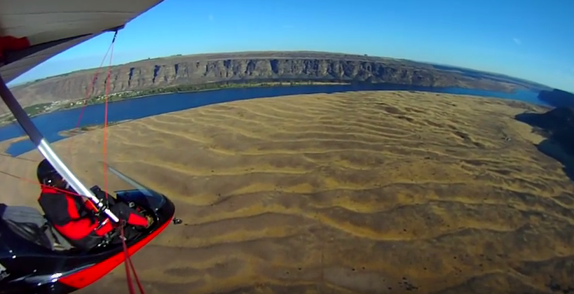
Check out this 2-Minute Geology expedition with Nick Zentner and Tom Foster exploring the Giant Current Ripples at West Bar and Camas Prairie. Ice age floodwater 650 feet deep – moving at 65 miles per hour – left Giant Current Ripples along the Columbia River at West Bar! The ripples at West Bar are 20 feet high, spaced up to 100 yards apart. Giant Current Ripples at Camas Prairie, Montana are also described. The Montana ripples helped Joseph Pardee understand that Glacial Lake Missoula had emptied suddenly. Learn more about Glacial Lake Missoula, Lake Bonneville and the Ice Age Floods at http://hugefloods.com/
Ice Age Floods Facebook Page
You may want to ‘Like‘ the Ice Age Floods Institute Facebook page to stay abreast of all the News and Shares coming out from the Institute. We’re sharing news and articles well beyond the Floods, including geology, natural history, general articles about the area, videoed talks, events, and any number of articles of general interest. Floods of water, floods of lava, rockin’ rocks, 2-Minute Geology, paleontology, and the mystical birth of the universe all get their 15+ seconds of fame. We’ll keep our eyes open to find and share items of interest to you, and of course you can share with us too.