Sea levels from the Maximum of the Last Ice Age to the Present Day

The Wenatchee Valley Erratics’ next program will be on Tuesday, June 13 at 7:00 PM at the Wenatchee Valley Museum and Cultural Center, 127 South Mission St., Wenatchee. Erratics’ member Kirk Laird will talk about “Sea levels from the Maximum of the Last Ice Age to the Present Day.” His presentation will focus on information directly available from NOAA’s Tides and Currents Office, and from NOAA’s Office of Satellite Altimetry. The 400 foot change in sea level over the last 22,000 years is directly attributable to the melting of continental and montane glaciers. With degrees in both Geology and in Oceanography, Kirk has observed earth science issues his entire life. And for the last 25 years, he has paid very close attention to the status of the oceans, in particular. This is a hybrid meeting. You can attend in-person at the Museum. Or you can participate via a Zoom link: https://us02web.zoom.us/j/84520197937 Please sign in at 7:00 PM, June 13! The program is free and open to the public.
Little Money Creek Gulch Fill
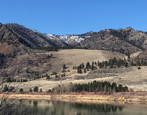
Mounds of soil, sand, gravel, and other coarse materials covered with light vegetation can be seen in the side gulches all along the Flathead River where tributaries drained into what was Glacial Lake Missoula. They were deposited by currents eddying into the slower water in these gulches and also by the drop in velocity of the streams carrying deposits from higher elevations on the far side of the river along the path of the escaping floodwaters. The flow of floodwaters through this narrow valley was estimated by J.T. Pardee at between 8 and 10 cubic miles per hours – more than the combined flow of all modern rivers in the world. Similar gulch fill can be seen in many locations along this beautiful stretch of the river, which today generally flows smoothly and looks completely flat. There are numerous pull-outs along MT 200 between Perma and Paradise; the view pictured here is at mile marker 91.
Othello Sandhill Crane Festival -March 24-26, 2023

The Othello Sandhill Crane Festival announced the 2023 theme as “Silver Anniversary, Celebrating Our Annual Visitors.” The 25 th annual festival will be held March 24-26, 2023 in Othello Washington. We are excited to be celebrating our 25th year! The festival celebration of the spring migration of the Sandhill cranes offers a variety of events for the whole family to enjoy and learn. The festival will be in the same locations as last year. The lectures will be held at the Othello Nazarene Church, 835 S 10 th Ave, Othello, WA. The Church is next door to McFarland Middle School where we will have the children’s art projects, the vendors, the photo booth, the Rotary breakfast, and the art contest. We will be utilizing both facilities. Food trucks will be available for lunches. Online registration opens on February 6, 2023. Visit the Othello Sandhill Crane Festival website for more information on the events at Website: othellosandhillcranefestival.org. Follow us for updates on Facebook: www.facebook.com/Othello-Sandhill-Crane-Festival Cathy Nowak will be one of the featured speakers on Saturday, March 25, at 7:30pm. Cathy will be speaking about Sandhill Crane nests and how experience matters, with both words and photos. Dr. Kaeli Swift will be the other featured speaker on Friday, March 24, at 7:30 pm. This lecture will require masks. Swift will explore commonly asked questions about crows, how crows have co-evolved with people, and what crows and other corvids can teach us about the nature of intelligence. Saturday, March 25, the lectures will cover cranes, birds, Ice Age Floods, the Drumheller Channel, and much more. We are planning tours by bus, bike, boat, car and self-directed, crane viewing tours will be back. Some tours will be set up over two weekends. The Children Activities Committee will have fun activities for kids such as binoculars made of toilet paper rolls to use for “birding” in the gym by finding pictures of various birds, origami folded crane mobiles, mask making and many other activities. We will again have the free photo booth to take your picture with a digitized Sandhill crane in the background to take home as a memento.
IAFI Booth at WSTA-CSTA Conference in Wenatchee

Ken Lacy of the IAFI Wenatchee Chapter hosted an information booth at the 2022 Washington Science Teachers Association Conference on Oct. 14-15 in Wenatchee, WA. His was the first use of a new table-top display that we recently developed for conferences, meetings and conventions. Ken felt the display,with its impressive graphics, showing maps and images of Ice Age Floods features, attracted a lot of interest and attention and fostered great opportunities to further engage with the conference goers as they came in for a closer look. He felt there was a high level of interest in the Ice Age Floods topic and people were keen to learn more about the floods, which led to many good conversations. It also gave Ken and opportunity to talk to as many as 10 ESD Science Coordinators about our project to provide 4th Grade level education materials about the Ice Age Floods. Their response was uniformly that this idea would not be well received because there was no time available for additional non-formulary classes. One of these Science Coordinators suggested it might be possible to combine our Floods program with an existing program, such as Language Arts, by presenting Floods information and having the students “prove” the existence of the floods by listing facts that supported this hypothesis. In another discussion with a retired school administrator about the issue of available time for our 4th Grade Floods program, she cited two examples of havin had to turn down outside offers of valuable educational programs because there was just not enough class time available for those programs. However, when Science Coordinators and teachers were asked about the idea of having IAFI people either conduct classes themselves or help the teachers develop such a class, the response was quite positive. The different response to the idea of our 4th Grade Floods program and the proposal for individual classes is significant in terms of class-time and preparation required. A single class session can often be fit into the schedule, but a multi-class program may cut too deeply into the time needed for required cirricula. Still, there are several sections in the Washington State Fourth Grade Curriculum that can support the inclusion of our proposed Ice Age Floods program. It will therefore be necessary for IAFI to work with the ESD Science Coordinators in each school district to get their support for the inclusion of our project.
Remembering Jim Pritchard

We’re sad to report that James “Jim” William Pritchard of Ephrata, WA, passed away on August 3, 2022. Jim was 95 years of age (born: September 4, 1926), was deeply interested in the Ice Age Floods, and was devoted to and involved with the Ice Age Floods Institute. A fond remembrance: In the fall of 2000, Charlie Mason gathered together anyone from the greater Wenatchee Valley with an interest in the Great Missoula Floods. He had taught adult classes at the Community College and led field trips and had quite a following. At that meeting, Charlie being the perfectionist that he was, held elections, called for name suggestions, took votes for the name Wenatchee Valley Erratics, and subsequently filed for 501-C status, knowing these all would be needed to charter the first IAFI chapter. The following spring, he and I attended the IAFI spring meeting (there were 2 board meetings every year back then), held at the Moses Lake Chamber of Commerce. Charlie and I presented everything he knew was needed, and the then-IAFI President, Dale Middleton, put to a vote that we would become an interim chapter. Charlie argued there was nothing more our group needed to do to become an actual chapter. It was argued for 20 minutes that we had to be an interim chapter first. After much debate, Jim Pritchard had had enough, quite forcibly told everyone to ‘shut up’, pointed out that Wenatchee was the first to file to be a chapter so set precedent, and put it to a vote. No more argument, and the Wenatchee Valley Erratics Chapter was born. Those of us who worked with Charlie, Dale and Jim over the years, might know that this meeting was much more ‘spirited’ than what I’ve indicated here. When I later joined the board, it was refreshing that Jim, who was treasurer, didn’t mince words, kept the meetings going, and brought a perspective that was down to earth and always well thought out. The Erratics were so lucky when in later years, Jim, and his wife Eula, made the drive from Ephrata to join our chapter meetings.He always brought interesting questions, and wasn’t shy to ask them. Ken and I were lucky to have visited with him last year after the death of Eula. He was still as sharp as ever, and as devoted to the story of the great floods. He will be missed. (by Susan Lacy)
Nick Zentner – More Geology Videos

Are you looking for new geology videos? Nick Zentner has done a long series live geology lectures from his home in Ellensburg and posted them online to his YouTube channel https://www.youtube.com/user/GeologyNick/videos He is now recording a series of “Nick on the Fly” virtual field trips and posting them on the same YouTube channel https://www.youtube.com/user/GeologyNick/videos Join Nick as he explores the geology of the Pacific NW and many other topics.
Use Social Distancing Time to Explore the Floods with Our Interactive Online Map
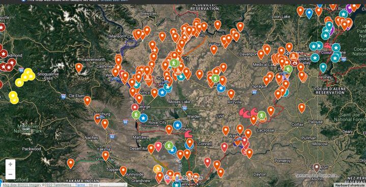
If you’ve ever tried to explore the Ice-Age Floods with a guidebook you’ll know how difficult and frustrating it can be to find and learn about the features in the area you’re visiting. Well, there’s now a solution to that problem; an interactive map that’s available wherever you have internet access. The map features over 300 points of interest throughout our 4-state area, with a description and images that slide out when you click on one of the markers. More features are being added all the time, and we’re planning to expand the map with features related to the Lake Bonneville Flood event that rampaged through the area during the time of the Ice-Age Floods. Since this is an internet-based map, it’s also easy to get driving directions to the site from wherever you are starting from. You can also easily build an informative field trip, exploring and learning about a number of other nearby features with just a few clicks of your mouse. We feel this may be the most useful field guide ever developed to explore ice-age Floods and glacial features throughout our 4-state region. AND it’s absolutely FREE! The only shortcomings we see are 1) the map requires internet access, which isn’t always available in far-flung areas of our region, and 2) we may not have every point-of-interest on the map (YET!). If we’re missing something you think is important we encourage you to submit your suggestion. We also appreciate any comments and/or corrections by email to Webmaster@IAFI.org. We sincerely hope you enjoy using this guide to poke around these fascinating ice-age features.
Explore the Ice Age Floods with 12 New IAFI Brochures

IAFI has compiled 12 brand-new, full-color brochures into a packaged set to help guide you in visiting spectacular ice-age features across all of our 11 Ice Age Floods chapter areas. With these brochures as your guides you can explore the paths of the Ice Age Floods from Montana through Idaho, central Washington and northern Oregon, and even delve into the many glacial features of northwest Washington. Click on any of the brochure covers below to see a full size printable PDF version (note: you’ll need to scale down to print on 8.5×11 letter size paper). Packets of all 12 full-size brochures are NOW available through the IAFI Store and at participating local outlets. Click a cover to open a PDF of any of the brochures below
Grand Coulee Area Hikes Report

Gene Kiver and Bruce Bjornstad led two hikes in the Grand Coulee area. A group of ~30 hikers joined in a moderately difficult hike into the Castle Lake Basin, part of a 4-mile wide cataract complex that extends all the way to Dry Falls. The hike started out near Coulee City by following the Main Canal, which delivers all water from the Columbia Basin Irrigation Project into two siphons that cross Don Paul Draw at the head of Deep Lake. From here the water disappears before flowing two miles, underground, through a pair of tunnels to Trail Lake Coulee. The hike continued by crossing a berm of basalt boulders, dug out for the Main Canal, into the Castle Lake Basin. A descent to the floor of the basin was possible via two steel ladders that crossed the cataract above the Castle Lake plunge pool. From there hikers traversed out to a potholed bench to a spectacular view above Deep Lake Coulee. The next day ~20 hikers joined a ~3 mile roundtrip hike to Giant Cave Arch, near Barker Canyon, along the west side of Upper Grand Coulee. For anyone interested, both these hikes are featured in “On the Trail of the Ice Age Floods: The Northern Reaches” a geologic guidebook published by Bjornstad and Kiver in 2012.
Castle Lake Basin
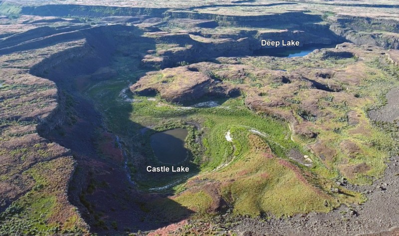
Castle Lake fills a plunge-pool at the base of a 300-ft tall cataract at the opposite (east) end of the Great Cataract Group from Dry Falls, above the east end of Deep Lake. A set of steel ladders put in place during the construction of the Columbia Basin Irrigation Project allow for a safe descent into the basin. In the basin are great views of giant potholes, the flood-sheared face of Castle Rock, as well idyllic Deep Lake. The Castle Lake Basin lies along the east end of the Great Cataract Group. At the base of the cataract is lovely blue-green Castle Lake plunge pool nestled into the rock bench below. Castle Lake lies within a single recessional cataract canyon eroded down to a flood-swept, pothole-studded rock bench that stands 100 feet above Deep Lake. This is the same rock bench of Grande Ronde Basalt where dozens of potholes occur at the opposite (western) end of Deep Lake. Castle Rock itself is an isolated butte along the west side of the Castle Lake basin. It is a faceted butte escarpment nearly sheared off by monstrous flood forces moving across the cataract.