Exploring Another Montana Flood
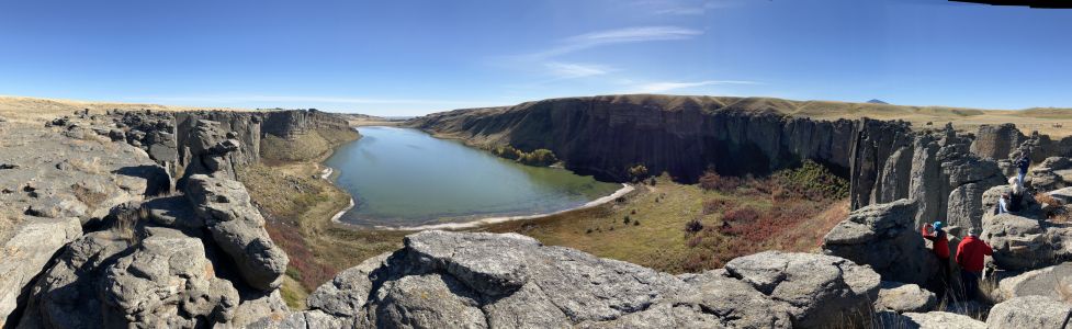
One of Montana’s other floods has been tickling the curiosity of some of our members.. This grew into a desire to plan a trip over to the upper Missouri River to see the channels from the diversion damming and outburst of Glacial Lake Great Falls. Thus, a reconnaissance was planned for 4 people. As the word got out everyone wanted to go and we wound with 14 souls on a loosely planned ‘let’s go over and see what we can find’ trip. The map below portrays Lake Great Falls when the Keewatin lobe of the Laurentide Continental Ice pushed the Missouri River out of its banks, pushing it south to the ice margin until the ice sealed off on the Bears Paw Mountains, then rapidly snaked off a sub lobe that sealed off on the Highwood Mountains. The lake began to fill to about 600 feet deep over Great Falls. It burst catastrophically at least once, creating the mile wide 500-foot deep Shonkin Sag (AKA Big Sag). This history appears to be a little more complicated than that as we turned up places where the last flood cut previous flood gravels. MBMG Special Publication 122: Geology of Montana, vol. 1: Geologic History by IAFI member DR Larry Smith is an excellent read for the details. This is a flood channel in soft rock (Cretaceous shale and sands). The lakes along the flood channels are endorheic (allows no outflow to other, external bodies of water or groundwater) so equilibrate by evaporation and are salty like the sea. The presence of these is a major clue the swale or drainage they are in is a flood channel. This is a flood channel in Shonkinite, a peculiar, dark igneous rock that would be basalt if it were not greatly enriched in potassium. Importantly it forms the columnar jointing common in basalt making it subject to plucking and the formation of retreat cataracts and geometry like the Washinton scablands. Note the column size. These are 5 to 10 feet in diameter and weigh many tens of tons but still the high surface area makes them subject to plucking if you have enough water moving quickly. We extracted a piece of Shonkinite gravel with blebs of white felspathoid syenite (like feldspar but having a different structure and much lower silica content) exsolving from Shonkinite magma like oil from water in salad dressing We stayed at Fort Benton, the historic steamship terminus on the Missouri river. Much of this is on private land and the landowner graciously allowed access to our group after being forced to close it due to trash and bad behavior. Lynne Dickman was the persistent silver tongued devil that made this happen. In all this was a very interesting reconnaissance of one of the other Montana floods. Article by Jim Shelden, President, Glacial Lake Missoula Chapter of Ice Age Floods Institute
Discovery Park bluffs tell the story of Seattle’s glacial history

The cliffs at Discovery Park in Seattle offer a glimpse into the past, revealing layers of sediment left behind by advancing and retreating glaciers. This “layer cake” of rock tells the story of the Cordilleran Ice Sheet’s movement over the Seattle area during the most recent ice age. Before we dive into the specific layers, let’s rewind time. Over 100,000 years ago, Seattle’s climate was similar to today, with a river system flowing north. As the Earth’s climate cooled and became wetter, the Cordilleran Ice Sheet began to form in what is now southeast Alaska and British Columbia. Fast forward to around 19,000 years ago. The massive ice sheet reached the Canada-US border, pushing southward and splitting into two lobes. One lobe went southwest down the Strait of Juan de Fuca, while the other, the Puget Lobe, advanced south over the Puget Sound region. When this lobe reached Port Townsend, it blocked the existing river, forming a giant proglacial lake. By 18,000 years ago, the unstoppable ice sheet had overridden the lake and covered Seattle. Water was forced to find a new route south through the Chehalis River system. Around 16,900 years ago, the glacier reached its maximum extent, pushing all the way to Olympia and reaching thicknesses of up to 3,000 feet over Seattle. Now, let’s explore the layers of sediment visible at Discovery Park: Olympia Formation: This is the oldest layer, formed before the most recent glacial advance. It consists of sand, clay, and silt deposited by a river system in a non-glacial environment. Imagine a climate similar to Seattle’s present-day with streams, ponds, and backwaters. Lawton Formation: As the ice sheet approached Seattle, a lake formed at the edge of the glacier. This layer is made up of dark clay deposited on the bottom of that lake. The fine-grained materials suggest deep, calm water. Esperance Formation: As the ice got even closer, the particles deposited changed. This layer consists of sand, with some gravel lenses, deposited by glacial meltwater in a high-energy environment. Vashon Formation: This layer, not visible at this specific location but found nearby, is the glacial till left behind by the retreating ice sheet. It’s a mix of all sorts of materials – clay, silt, sand, pebbles, and boulders – deposited as the glacier melted. These layers at Discovery Park serve as a record of Seattle’s glacial past, offering a window into a time when massive ice sheets ruled the landscape. Click here to read a more detailed article written by Dale Lehman, President of the Puget Lobe Chapter, about this interesting glacial feature.
Hike to Large Erratics in Gingko Petrified Forest State Park

In the approximate center of the state of Washington is the Gingko Petrified Forest State Park. And within the park is a trail, unnamed, which offers opportunities to view evidence of the terrific capabilities of the Ice Age Floods to transport huge boulders and leave huge deposits of rock material. The trail is off I-90 at exit 136 to the town of Vantage. After exiting the freeway travel north through Vantage for almost a quarter mile and turn right onto Recreation Dr. There is a sign to “Rocky Coulee Recreation Area.” It’s the old Highway 10 leading down to Lake Wanapum. This 0.3 mile section of road from the turn is bisecting the western margin of an eddy flood bar. The bar is about 0.75 mi in length and 0.25 mi in width. It extends down to the recreation area. At the end of this 0.3 mile section of road is the trailhead on your left. Parking is available here. A Discover Pass is required. The road continues another quarter mile to the Rocky Coulee Recreation Area at which restroom facilities are available. You could also park there. The trail starts along a slope above the Rocky Coulee. The bedrock here is all dark colored basalt. But deposited intermittently on the ground are light colored granitic rocks. Because they are not from this bedrock and are of a different composition than the basalt they are termed erratic. Where did they come from and how did they get here? That is the story of this hike. The last outburst floods from Glacial Lake Missoula are thought to have happened about 15,000 years ago. Huge chunks of ice, icebergs, broke away and carried whatever rocky material they had impounded during years of emplacement. The icebergs likely came from the Cordilleran Icesheet as it failed. This material was often granitic boulders and cobbles. Erratics here might have come from Rocky Mountain “Belt” bedrock or from glacial ice transporting Columbia-Okanogan valley bedrock and alluvium. When the flood waters made their way to this location, some 200 miles from their origin near Pend Oreille, they encountered some constrictions in the terrain which slowed their progress. The most significant constriction affecting this area was Wallula Gap, 70 miles south. It was less than 2 miles in width. That sounds like a wide gap but it was enough to prevent free flowing of these huge floods. Another, but less significant one, was Sentinel Gap, 10 miles to the south. Upon the waters slowing, eddies formed and the icebergs got caught up in those. The temporarily impounded water backed up onto these slopes. This resultant body of water has been named Glacial Lake Lewis. Inevitably some of the bergs became grounded on the slopes in the area. The highest erratic here is at 1,263 ft. The maximum water depth was about 800 ft. That’s about 700 ft above the existing water surface of Lake Wanapum reservoir. In the adjacent Schnebly Coulee erratics go up 3.5 miles. It’s estimated Lake Lewis existed and then drained within a few days, probably no more than a week. Upon the water finally receding through the gaps, with much less energy than upon arriving, the icebergs were left behind. Over time the bergs melted leaving behind their loads. These slopes are littered with hundreds of erratics. As you walk you can spot them along the trail. Most of them are small to moderate in size: less than 3ft². About a quarter of a mile into the hike the road starts taking a 90° right turn. As you round that turn you can see that Rocky Coulee below you takes a sharp turn to the south before again traversing to the east. It is quite possible the slope on which we are standing, a landslide, blocked the coulee and constricted that tributary’s water flow. As the water rose high enough to overcome the barrier it found a newer path to the south of its original course. We’ll see more evidence of the landslide up the trail. In another quarter mile, about half way to our destination there is a group of erratics on the right of the trail. There is more than one within a 3 foot radius so that makes it a cluster. But with fewer than 10 rocks in a 30 foot transect and the ground surface not greater than 3 feet higher than the surrounding terrain this is defined as a Low Density Erratic Cluster. This is a definition derived by a Central Washington University Masters student, Ryan Karlson in 2006. It incorporates a definition given by Bruce Bjornstad. At this same location you can look to the north and see a head scarp from a translational landslide. This whole hike is on a landslide. Looking to the east you can see hummocky terrain. So, there are 3 signs of landslide on this hike: head scarp, hummocky terrain, and the irregular tributary channel seen earlier. The soil here is very thin and nutrient poor: lithosol. It forms from weathered basalt, windblown loess, and volcanic ash. (You can still find ash from the 1980 Mt St. Helens eruption). It mainly supports a few species of sagebrush and bunchgrass along with seasonal wild flowers. Among the fauna found here are deer mice and ground squirrels. There are abundant Elk droppings you will see when leaving the trail to reach the destination erratic. I have seen a video of an Elk herd I would estimate was well over a hundred, perhaps two or three hundred running across nearby terrain. It was incredible! Traveling up the trail another quarter of a mile you can see the destination erratic off to the left on the trail. It will take about a quarter of a mile walk off the trail to get to it. This erratic is the single largest one in the park area at 85 ft². It’s 10 feet long and 8.5 feet high. It lies in a High Density Erratic Cluster, so
Unearthing the Secrets of Spokane Valley: A Recap of the IAFI June Jamboree
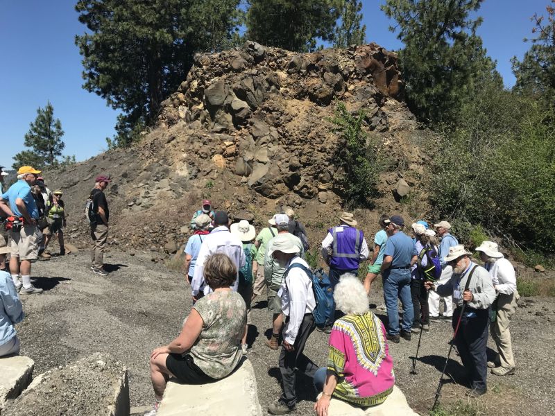
This year’s IAFI June Jamboree delved into the fascinating geological history of Spokane Valley, contrasting it with the iconic Grand Coulee and Dry Falls, explored during last year’s Jubilee. Challenging the Landscape: Unlike the open spaces of Dry Falls, Spokane Valley presented a unique challenge – showcasing evidence of Ice Age Floods within an urban environment. Our chapter tackled this brilliantly, organizing hikes and car caravans departing from convenient public parks and commercial areas. Evening Explorations: The program’s highlights included captivating lectures. Professor Emeritus Dean Kiefer shed light on J Harlen Bretz’s Spokane associates, while renowned naturalist Jack Nesbit brought the story of the first Columbian Mammoth discovered near Latah Creek in the 1800s to life. Celebrating Success: The Jamboree culminated in a relaxed gathering at Mirabeau Meadows. Registrants, leaders, and participants exchanged insights and experiences, with a resounding appreciation for the chapter’s efforts. Comparisons were drawn, highlighting how our Spokane Valley exploration continued the excellence of the Puget Lobe’s outing at Dry Falls last year. A Delicious Finale: The grand finale was a catered Longhorn Barbecue overflowing with delicious food. Everyone left satisfied, with many even taking home doggie bags to savor the flavors afterward. Check out more images from the event in this Google Photo Album. Meet the Masterminds: Linda & Mike McCollum: This dynamic professor emerita and a research geologist duo co-led tours and car caravans, sharing their latest research on the Spokane area’s Ice Age Floods, and shaping the Jamboree’s theme. Michael Hamilton: A gifted geologist, Michael led hikes and the bus trip, encouraging questions and offering honest answers. Don Chadbourne & Chris Sheeran: Don, the chapter treasurer, managed logistics with expertise, while Chris, our media and registration guru, ensured a smooth experience. Melanie Bell Gibbs: A past president and national board member, Melanie oversaw participant check-in and badge distribution. Dick Jensen: Dick handled bus transportation and provided crucial support throughout the Jamboree. Jim Fox: The chapter vice president secured speakers and offered his assistance wherever needed. We also owe a great deal to the participant volunteers who proved invaluable in assisting us in all our efforts. Through the combined efforts of many the IAFI June Jamboree was a resounding success, fostering exploration, education, and a deeper appreciation for the Spokane Valley’s unique geological heritage. Being present with so much information and conversation among such extensive expertise was to witness the scientific process in action. Meeting people from other chapters was particularly nice, putting faces with names we know. We all learned a lot.
Scabland – The Movie, A Google Earth Odyssey

“Scabland” – the Movie, A Google Earth Odyssey “Scabland” is a media complement to CWU Professor Nick Zentner’s 2023-2024 A-Z YouTube geology series that re-treads the ice age floods and the work of Professor J Harlen Bretz and others. In this short animation, viewers virtually fly to a selection of locations visited by geologist Dr J Harlen Bretz, with quotes from his original field notes, geolocated in Google Earth and animated with Google Earth Studio. To see more of these locations, visit https://www.geology.cwu.edu/facstaff/nick/gBRETZ/ This video was done as an experiment/prototype by the authors, Glenn Cruickshank and Eric Larson, to showcase Google Earth, virtual special effects techniques, some of the spectacular landforms caused by the floods, the impacts of ice and water during the Last Glacial Maximum and the field locations of J Harlen Bretz. Eric Larson in Billings MT runs Shashin Studio, a VFX video production company (contact@shashin.studio). Google Earth Glenn is a retired photojournalist and consultant in Liberty Lake WA. Credits: Glenn Cruickshank Eric Larson Two Steps From Hell Made with Google Earth and Google Earth Studio. Thanks to The Families of J Harlen Bretz and Thomas Large, Nick Zentner, Glenn Cruickshank, Bruce Bjornstad, The Ice Age Floods Institute, and many others.
Visit Wenatchee, Washington – Explore Ice Age Flood Features

Wenatchee, Washington is often called the “Apple Capital of the World” or the “Buckle of the Power Belt of the Pacific Northwest”. Today the Wenatchee vicinity is known for the fruit industry, wineries, power generation, tourism and outdoor recreation. When you visit and look around the Wenatchee Valley, even today, much of the landscape was formed by Ice Age Flooding. Visit the Wenatchee Valley area to explore some of the interesting Ice Age Flood features found there. Toward the end of the Pleistocene Ice Ages (17,000-12,000 years ago) much of the landscape in the Wenatchee area was changed substantially by catastrophic ice-age flooding. These flood(s), almost 1,000 feet deep, initiated out of glacial Lake Missoula in Montana, and some of the largest came through the Wenatchee area along the Columbia River drainage. Prior to the Okanogan Ice Lobe blocking the Columbia River valley north of Wenatchee, the early Missoula flood(s) could follow the present day path of the Columbia River around the “Big Bend” area of north-central Washington into the Wenatchee area and further south. Take a drive north of Wenatchee on highways US 97 or US 97A to see evidence of this flooding. As the Okanogan Ice Lobe advanced south it eventually blocked the Columbia River drainage north of Wenatchee. The water backed up by that Okanogan Lobe ice dam formed glacial Lake Columbia and forced subsequent ice-age floods to be funneled southward along the east edge of the ice lobe into Moses and Grand Coulees, and farther east through the Channeled Scablands of eastern Washington. When the Okanagan ice eventually retreated, one last flood from glacial Lake Columbia again followed the Columbia drainage through Wenatchee. Massive boulders (some 40 feet in diameter) and erratics (rocks foreign to the area) were transported at the base of the flood waters and embedded in huge icebergs floating on the floodwaters. They were deposited along the hillsides throughout the Wenatchee area as the floods waned and the icebergs became stuck and melted. Those erratics prompted our Ice Age Floods Institute chapter name “The Wenatchee Valley Erratics”. The two main erratic rock types in this area, granite and gneiss, are much different from the Eocene Chumstick Sandstone bedrock. The gneiss erratics transported a relatively short distance from outcrops just north of Wenatchee are often 10 feet in diameter. The nearest granite outcrops occur some 15 miles upstream in the Entiat area, so the granite erratics tend to be smaller, less than 3 feet in diameter. Some of the best locations to see these erratics are just south of the Old Wenatchee Bridge (first bridge over the Columbia River finished in 1908) along the Apple Capital Loop Trail near Patriot Plumbing & Heating, the Department of Social & Health Services and near the old train at Mission Street Park in south Wenatchee. An enormous crescent-pendant Pangborn Bar topped with huge current ripples was deposited in east Wenatchee where the Columbia River drainage takes a right (easterly) turn. The bar elevation is 500 feet above the Columbia River today. On the surface of Pangborn Bar are giant current ripples with crests up to twenty feet tall and ripples spaced some 300 feet apart. Travel up Grant Road, 4th Street in East Wenatchee and then out onto Batterman Road northwest of Rock Island to travel across the entire Pangborn Bar from west to east. The giant current ripples are best observed on 2nd or 4th Streets, where these roads go up and over the current ripples east of Nile Avenue in East Wenatchee, Washington. Just about a mile northeast of Pangborn Memorial Airport is a very significant archaeological site, the East Wenatchee Clovis Site (Richey Clovis Cache), discovered in 1987 and excavated until the site was closed and covered in 2004. This site lies on top of one of these current ripples. Pristine Clovis spear points as well as other archaeological specimens (about 11,000 years old) were discovered and some are now on display at the Wenatchee Valley Museum and Cultural Center in Wenatchee. Article from Brent Cunderla, April 2024
Field Trip to Dam Site

A field trip to Sandpoint ID to visit geologic sites related to the ice dam(s) that blocked the Clark Fork River and caused the formation of Glacial Lake Missoula multiple times is planned by the Glacial Lake Missoula Chapter in cooperation with Tony Lewis of the Coeur de Deluge Chapter. An all day bus trip is planned for April 18th followed by a car caravan to Farragut State Park and other downstream sites the next day. Registration for the event is limited and is being handled by the Montana Natural History Center at https://events.humanitix.com/ice-dam-field-trip Discounted lodging reservations are available at the Schweitzer Resort until March 18th. For more information contact Sherry McLauchlan 406-207-7760.
Puget Lobe Chapter Newsreels – A Continental Ice Sheet Background Perspective
(27Jan2024) This post contains the newsreels shown at the bginning of our Chapter meetings. Newsreels oroginally contain: the current presenter, future presenter, Chapter/IAFI current information, and the “newsreel” of selected technical information germane to Continental Ice Sheets. The newsreel after the meeting is then parsed to show just the selected technical information about Continental Ice Sheets. Each chapter describes a certain facet of the history of the ice sheets. These chapters are an exact copy of what was shown at the meeting and are designed to fill the 10-15 minutes prior to the meeting start. Subsequently, the chapters will be revised to add additional subject matter about that chapter subject. And a revision date will be included so you, the viewer, will be able to see the expanded information. You need to click on the links below, then click the little window that shows up to see the synopsis/newsreel: Since it’s a .pdf file, you may have to adjust the size of the page as you scroll through the newsreel on your computer. The current Synopsis is for meeting on: In work intro: Chapter 1 Introduction – Milankovitch Hypothesis 01 Newsreel CH 1 pdf dtd: 29Sep2020 Chapter 2 Earth’s orbital perimeters 02 Newsreel CH 2 pdf dtd: 25Oct2020 Chapter 3 Defining the Pleistocene 03 Newsreel CH 3 pdf updtd: 05Oct2021. Chapter 4 Marine Sediment Cores 04 Newsreel CH 4 pdf updtd: 06Feb2021 Chapter 5 Fraser Glaciation Puget Lobe 05 Newsreel CH 5 pdf updtd: 06Feb2021 Chapter 6 Double Bluff/Possession LGM 06 Newsreel CH 6 pdf updtd: 07Feb2021 Chapter 7 Hood Canal Geology 07 Newsreel CH 7 pdf updtd: 07Feb2021 Chapter 8 Alpine, Cordilleran, Surging Glaciers 08 Newsreel CH 8 pdf 02Mar2021 Chapter 9 Dungeness River, Pillow Basalt 09 Newsreel CH 9 pdf dtd: 01Sep2021 Chapter 10 FS23 Olympic NF, Kame Terrace 10 Newsreel CH 10 dtd: 24Oct2021 Chapter 11 FS2340 and Dennie Ahl Esker field 11 Newsreel CH 11 dtd: 07Dec2021 Chapter 12 FS2340 Outwash Channel/Crag& Tail 12 Newsreel CH 12 dtd: 15Jan2022 Chapter 13 FS23, Rock Creek Canyon, Spider Lake 13 Newsreel Ch 13 dtd: 02May2022 Chapter 14 Port Ludlow Geological History 14 Newsreel Ch 14 See current Synopsis. DRAFT in work – URLs work.
Postmortem on the southern Cordilleran Ice Sheet

(21Feb2024) On 18 March 2924 at 7:00pm the Puget Lobe Chapter io the IAFI will have Dr Ralph A Haugerud give his presentation “the Postmortem on the Southern Cordilleran Ice sheet. Death of an ice sheet can have many causes, as shown by retreat of the southern Cordilleran ice sheet about 15,000 years ago. East of the Cascades, the margin of active south-flowing ice retreated north as less snow fell and more melted. West of the Cascades, the Juan de Fuca lobe of the ice sheet appears to have floated away in response to rising sea level, perhaps without a proximal climatic cause. Collapse of the Juan de Fuca lobe diverted ice from the Puget lobe, which consequently stagnated at its margin and rapidly melted back. Later Sumas ice readvance in the Fraser Lowland may reflect stabilization of the remnant ice sheet by grounding as local sea level fell, followed by climate-driven retreat. Ralph Haugerud received B.S. and M.S. degrees in Geology from Western Washington University and a Ph.D. in Geological Sciences from the University of Washington. Since joining the USGS in 1986, he has worked in the North Cascades Range, the Salish Lowland, and the Columbia Plateau. From 1990 to 2014 he was technical lead for the Puget Sound Lidar Consortium, and he has been instrumental in developing the GeMS standard for representing geologic maps in a Geographic Information System (GIS). His current efforts focus on the structure of Eocene strata in central Washington, features formed by glacial Lake Missoula outburst floods, and regional map compilation. The in-person portion will be at Bellevue College Bldg R, Rm R103. See separate post for location details. For this meeting only there will be NO “Zoom” available.
Puget Lobe Chapter Meeting Location

The Puget Lobe Chapter meets at Bellevue College, Bldg “T”, Room 127, just off I-90. The closest parking lot to the T building is lot 8. There is a cost of $3.00 per vehicle to park. Our presentations are livestreamed on Zoom https://us02web.zoom.us/j/82985244730