Lake Lewis High Water Markers Installed
In April, 2017, Lake Lewis members George Last and Bruce Bjornstad worked with Friends of Badger volunteers Jim Langdon (Trail Master) and David Beach to install Markers showing the Lake Lewis high water marks on Badger and Candy Mountains near Richland, Washington. The Lake Lewis Chapter donated $300 to the Friends of Badger Mountain to purchase the two faux erratics engraved with “Lake Lewis Maximum Elevation 1250 Feet”. One of the markers was installed along the Sagebrush Trail on Badger Mountain, and the other along the Candy Mountain Trail. It was a glorious day!
Getting Our Palouse Falls “WOW” Story Out
A few of us met two years ago in August to decide if we should start our own chapter. We asked the question, “How do we get the word out to see how much interest there is?” We decided the best way to do this was to the attend the upcoming local fairs – Wheatland Communities Fair in Ritzville over Labor Day weekend, the Palouse Empire Fair outside of Colfax the following weekend and the Adams County Fair in Othello the weekend after that. We were fortunate to still be able to get booth space for the first two fairs and to share with the Coulee Corridor (at no cost) for the last one. We quickly rounded up pictures, maps, and books to fill our first booth. We talked to a lot of interested people and signed up new members for our chapter. This year we decided to do the three weeks of fairs again. The Coulee Corridor allowed us to use part of their booth again to help out our fledgling chapter – we will be able to go solo next year. There are a number of good reasons to take the time and expense to do these fairs. We recognize existing chapter members. We advertise our upcoming lectures. We promote our fall bus tour. We sign up new members. We share our flood story. This year we had time to create a more professional booth including local rock samples. This was a good draw for the young visitors as well as the adults. We also had samples of Mount St. Helens ash from the local area and Yakima. It was a great dialog starter – Why are the two samples different? Answer – the local ash is finer and the Yakima ash is coarser because the heavier material dropped out closer to the mountain. We also met with people who were visiting from outside the flood path or had just recently moved in from out of the area. I would ask them if they were familiar with the Missoula floods. Some knew nothing and others just a little. I would tell the story, pointing to the map showing Glacial Lake Missoula and the flood path. The one superlative I would hear over and over again was “WOW”. It reminded me of just how much of a “WOW” area we live in and how easy it is to forget that when you have lived in it all your life. Yes we do live in a “WOW” area and the local fairs have been a great venue to get our “WOW” story out to the public. Lloyd Stoess, President Palouse Falls Chapter, IAFI
Beryllium-10 dating of late Pleistocene megafloods and Cordilleran Ice Sheet retreat
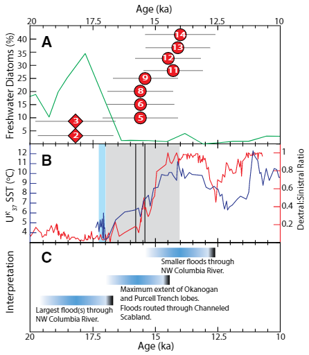
Balbas et. al. use cosmogenic beryllium-10 dating methods to further constrain the timing of ice sheet retreat, as well as the potential pathways for megafloods from both Lake Missoula and Lake Columbia. Read this fascinating Geology article summarizing their findings. Balbas2017 – Missoula Flood Chronology In summary, our new chronological information suggests the following: (1) Blockage of the Clark Fork river by the Purcell Trench lobe by ca. 18.2 ka, resulting in Missoula floods following the Columbia River valley. (2) Blockage of the Columbia River valley by the Okanogan lobe before 15.4 ± 1.4 ka, which shunted Missoula flood water south across the Channeled Scablands. (3) The final Missoula floods at ca. 14.7 ± 1.2 ka, signaling retreat of the Purcell Trench lobe from the Clark Fork valley, yet these floods entered a glacial Lake Columbia still impounded by the Okanogan lobe. (4) Down-Columbia floods at ca. 14 ka from breakouts of glacial Lake Columbia, signaling the retreat and final damming of the Columbia Valley by the Okanogan lobe
German Marshall Fund Fellows Visit Gorge Floods
On May 6th a group of 6 German Marshall Fund (GMF) Fellows from Europe and Russia got a taste of the Ice Age Floods story as they toured the Gorge, shepherded by Krystyna Wolniakowski, the Executive Director of the Columbia River Gorge Commission and a past-fellow herself. This was their last day to do some sightseeing before heading home after three weeks of intensive presentations and meetings with experienced business and political leaders. After being wowed by the scenic beauty and amazing wines of the Gorge they came to Rowena Crest for a brief discussion about the Ice Age Floods at this incredible vantage point. IAFI Gorge Chapter leader, Lloyd DeKay, used maps and illustrations and pointed out several local Floods features to help tell our story of the 1000′ deep floods that roared across the landscape and through Rowena Gap, crashing against and over this promontory on their devastating path to the sea. These Fellows came away awed by the many wonders of the Gorge, and feeling like they had the crowning experience of all the GMF groups touring the States and Europe. The GMF-funded Fellowship Program is a leadership development program intended to help build networks and develop effective transatlantic relationships and engagement for future world leaders. Each year 70+ GMF Fellows are stringently chosen from hundreds of up-and-coming business and political leaders from both sides of the Atlantic. Each small “class” is supported for 6 months of focused distance learning and 24 days of first-hand travel and experiences as they meet and learn from high-level business and political leaders. It was humbling for us to have played a small part in contributing to the experiences of this dynamic group of future world leaders.
Washington’s Ice Age Floods – ESRI Story Map
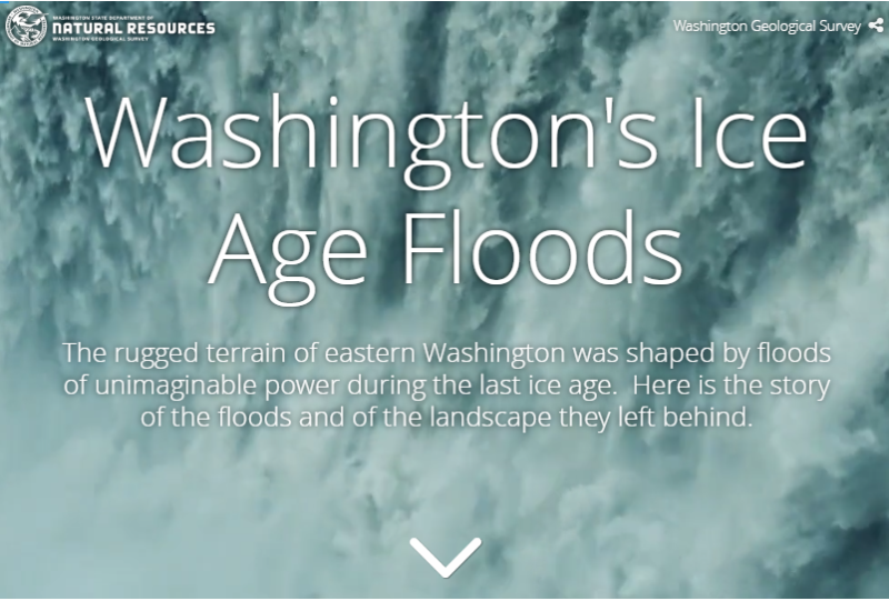
The Washington Geological Survey (formerly the Division of Geology and Earth Resources) has just released an ESRI story map about the Ice Age Floods in Washington. The story map: “tells the story of cataclysmic outburst floods that shaped the landscape of the Pacific Northwest during the last ice age. With imagery, maps and video, this story map follows the devastating deluge of the Missoula floods as it tore across the landscape, from its origins in western Montana to its terminus at the Pacific Ocean. Sites along the Ice Age Floods National Geologic Trail are featured, with an emphasis on flood features in Washington State.” Entitled Washington’s Ice Age Floods, it is best viewed on a desktop or laptop computer. Mobile devices will not show all of the content. It is navigated by scrolling your mouse through the slides. There are a few animated sections that may take a second or two to load. [weaver_iframe src=’https://wadnr.maps.arcgis.com/apps/Cascade/index.html?appid=84ea4016ce124bd9a546c5cbc58f9e29′ height=600 percent=100]
Lake Lewis Isles Tour
Lake Lewis Isles, Badger Mt. Centennial Preserve and Skyline Trail Best Observation Points By Auto: 1. Along State Route, SR 240 near mile posts 24-26, and along SR 224 and Interstate, I-82, in Richland and Kennewick, WA. 2. Along I-182 near Road 68 in Pasco, WA. Lake Lewis Isles Trails Off-road trails ascend Badger Mountain, Red Mountain and Goose Hill, located south and west of Richland, Washington. These and two other neighboring hills were mere islands that poked out above Lake Lewis when floodwaters backed up to over 1,200 feet in elevation behind Wallula Gap (Figure 1). Badger Mountain Trails Badger Mountain Centennial Preserve is owned and operated by Benton County of Washington State. It was created as the result of a grassroots campaign led by the Friends of Badger Mountain to preserve the mountain as public open space. The preserve is now home to five trails, accessed via two different trailheads, one at Trailhead Park, and one off Dallas Road (Figure 2). Trailhead Park Location: N 46.238404°; W 119.306286°, parking lot of Trailhead Park located at 525 Queensgate Dr., Richland, Washington. To access this trailhead take Exit 3A (Queensgate Drive South) off Interstate I-182 south of Richland, Washington. Proceed 0.5 miles and turn left (east) onto Keene Road. Proceed 0.6 miles east to Shockley Road (near Bethel Church) and turn right. Follow Shockley Road to the end, where you turn left on Queensgate Drive, and go up the hill to the stop sign, where you turn right on to White Bluffs St. and then turn left into the parking lot. Trail Length / Difficulty: From this trailhead hikers have their choice of three trails – Canyon Trail (1.3 miles / Moderate), Sagebrush Trail (0.6 miles / Easy to Moderate), or Badger Flats Trail (0.4 miles / Easy). Dallas Road Trail Head Location: N 46.242209°; W 119.342810°. To access this trailhead, take Exit 3B (Queensgate Drive North) off Interstate I-182 south of Richland, Washington. Proceed 0.2 miles and turn left (south) on to Duportail Street. Proceed approximately 0.7 miles and turn right (west) on to Keene Road. Proceed another 0.6 miles and turn left on Kennedy Road. Stay on Kennedy Road for 0.6 miles and turn left (south) onto Dallas Road. Follow Dallas Road for 1.2 miles, going under the I-182 overpass and continuing to the top of hill, then turn left onto a gravel road that takes you to the trailhead. Trail Length / Difficulty: From here hikers have their choice of the Skyline Trail (2.9 miles / Moderate), or Southside Trail (2.5 miles / Easy). Skyline Trail offers spectacular views of the Lake Lewis Isles. Warning: Outside of Trailhead Park there is no shade or portable water. Skyline Trail Description (after http://hiketricities.com/badger-mountain-dallas-road/) The trail winds and climbs gradually through virgin sagebrush. As you reach the top of the sagebrush field, you’ll cross over a dirt road that provides vehicles access to the communication towers on top of Badger Mountain. Across the road, you’ll get spectacular views of Candy Mountain and Red Mountain to the west, two of the Lake Lewis Isles. You will also get great views of the lower Yakima Valley, Richland, West Richland and the Hanford Site (a.k.a. Hanford Nuclear Reservation). Following a few switchbacks, you’ll continue climbing up the ridge. You’ll pass a granitic marker where geologists believe temporary Lake Lewis reached its maximum elevation, submerging the Tri-Cities with over 800 feet of water (Figure 1). Here you have a great view of Rattlesnake Mountain, the Hanford Site, and the Hanford Reach National Monument. Continuing up the mountain, you’ll hike through desert grasses, with plentiful wildflowers in early spring. As you reach the spine of the ridge, you’ll again cross the dirt access road. At this point you have a view of the Horse Heaven Hills and Badger Canyon and as well as the lower Yakima Valley. The trail winds around the south or “back” side of Badger Mountain, passing a couple of communication towers, and then splits. Follow the left fork. The right fork will take you back down to Trailhead Park via the Sagebrush Trail. Follow the trail up to the tower and enjoy the view! On a clear day, you can see the Blue Mountains to the east along with the Tri-Cities, Columbia and Yakima Rivers, Hanford and Badger Canyon. On a clear day, you may get a glimpse of Mt. Adams, over 100 miles to the west. You can either retrace your steps or follow the dirt road back to where the upper trail crosses and then take the trail back down. Taken, in part, from On the Trail of the Ice Age Floods by Bruce Bjornstad1 and the hiketricities.com website. Bjornstad, B. N. 2006. On the Trail of the Ice Age Floods: A geological field guide to the Mid-Columbia Basin. Keokee Books, Sandpoint, Idaho.
George Last – President (Renewed) of Lake Lewis Chapter
George Last was recently elected president of the Lake Lewis Chapter. Many of you who have been in IAFI a long time will remember that George was the chapter president for 10 years. After a break of a few years he is again chapter president. We are pleased to have him as an IAFI Director again. Gary Kleinknecht is especially pleased to have George as chapter president as this will permit Gary to spend more time at the dig and conducting field trips. Gary will continue to be on our board as a Director and our vice president. George was one of the major people who developed the Lake Lewis chapter brochure and thus has detailed knowledge of the process. We will be asking George to provide guidance, as needed, to the other chapters on their brochure work. This should include the easiest way to get this work done as well as how are we going to get the maps done, which is a major hurdle we need to get over. We are confident with George’s guidance we can get this work done in the most efficient manner.
Did humans witness any megafloods?
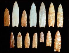
Richard Waitt kindly shared his recent paper published June 2016 in Quaternary Research, titled “Megafloods and Clovis cache at Wenatchee, WA.” “It covers the reach mainly from Chelan Falls to below West Bar, tries to tell the story of sequential megafloods coming to Wenatchee area by different routes at different times, and tries to work in the story of early Homo sapiens in the region, especially as contemplated from the 1988-1990 excavations of the East Wenatchee Clovis cache,” said Waitt in an email to the Wenatchee Valley Erratics. His easy-to-read and immensely interesting paper covers both the geological and the archaeological stories for the Wenatchee area. Did humans witness megafloods? Read the paper Megafloods and Clovis cache at Wenatchee, Washington to find out!
CWU’s Geology of Washington Course: Free
People of all ages and backgrounds are welcome and invited to attend any of these lectures free: Geology of Washington (GEOL 101 section 02) 10:00 – 10:50 am MTRF (no lectures on Wednesdays) CWU’s new Science II building – room 103 Fall Quarter Sept 22 – Dec 6, 2016 Instructor: Nick Zentner This is the 15th quarter we’ve had a handful of “townies” in addition to the CWU students. Plenty of room for you and friends. For the “townies”…we’re real casual. No registration, no auditing, no reserving seats, etc. Come whenever you’re in the mood. Take the whole class or just a few lectures. Free parking is handy just north of Memorial Park on E. 7th Avenue. The new Science II Building (Geology & Physics) – room 103 – is just a couple of buildings north of Lind Hall (our old home). See attached map. Our first class is Thursday, Sept 22 at 10:00 am.
Columbia Basin Plays a Hand in Mars Mission
— By Jill FitzSimmons, editor@qvpr.com, reprinted from Quincy Valley Post Register What possibly could the Columbia Basin and its channeled scablands have in common with the Red Planet, millions of miles away? Turns out, more than you would think. Scientists believe that billions of years ago Mars experienced not only volcanic episodes but also great floods that carved out massive, stark cliffs and ancient bodies of water. Left behind were the Red Planet’s scablands. Sound familiar? Back on earth, millions of years ago the lava that flowed over the Columbia Basin was the first in a series of catastrophic events that came together to shape this area. The lava flowed over vast areas, only to cool and then be carved by massive glacial floods. The Columbia Basin is the only place on the planet that comes close to having the geologic features of those found on Mars, said Melissa Rice, assistant professor of planetary science at Western Washington University. Both the Red Planet and the Columbia River Gorge were formed by catastrophic floods that scoured the landscape, Rice said. “This is the only place in the world where this exact thing has happened,” she said recently from the home of Ken and Susan Lacy that overlooks the dramatic cliffs of Crescent Bar, the Columbia River Gorge and the West Bar’s giant ripples – all signs left behind from the Ice Age floods. Rice was among 30 scientists, engineers and graduate students from around the nation and the globe who visited the area last month on a mission to get a close-up and personal view of the local channeled scablands. Some of those who visited the area are among the world’s top Mars scientists. The two-day visit came as the team prepares to get down to work designing and building a camera system that will be on the next rover mission, to be launched in 2020 and on Mars in 2021. Scheduled to operate on Mars for 10 years, the rover will search for signs of past life on the Red Planet. The team decided to meet up for two days of touring and getting to know one another before heading to a rover-planning meeting in Bellingham. The gathering in Eastern Washington was the closest they could get to the next best thing. “We don’t get to go to Mars,” Rice said. In their trip around the area, the team on its first travel day visited the Ginkgo National Forest near Vantage and the Frenchman Coulee. They went to an overlook near the Potholes Coulee to see the butte-and-basin topography. They even stopped on Trinidad Hill, where, dressed in orange vests, they got out of their cars to feel the Eastern Washington basalt. On Day Two, they were headed to Dry Falls and the Moses Coulee. At the Lacy home, several members of the team walked out the couple’s back door and gasped as they took in the view of the river and its gorge. Jeff Jones, planetary geologist at John Hopkins University’s Applied Physics Laboratory, described the area as a “great geologic experience.” Dr. Kjarton Kinch of the University of Copenhagen in Denmark, the world’s expert on Martian dust, was excited to hear the flood stories from Ken Lacy. Kinch called the local scenery “spectacular.” The rover the team is helping to design will be the fifth to be sent to Mars. In past missions, the rovers have had unique objectives, such as searching for signs of habitability or evidence of water on Mars. “This is the first mission actively searching for signs of past life,” Rice said. Scientists are searching for “bio-signatures,” or pieces of evidence that may exist in the rock record on Mars, Rice said. While the bio-signatures could exist in many forms, such as a dinosaur bone sticking out of the ground, scientists likely are looking for concentrations of organic molecules, the building blocks of life, preserved in the rock, Rice said. Rice and her team are designing and building the instruments that will be used to search for those bio-signatures. The instruments will be installed on a long, skinny neck, called a mast, at the front of the rover. The cameras will serve as the eyes of the rover, Rice said. After leaving Eastern Washington, the scientists were headed to a “community meeting” of scientists that were to narrow down the landing sites for the 2020 rover. Thirty potential sites were narrowed to eight. Those eight will be taken down to four in January, and the camera team will discuss which of those sites it wants to support, Rice said. “We only get to drive around 10 kilometers, so the landing site is important,” Rice said. Ken Lacy, a board member of the Ice Age Flood Institute, said that by inviting the group into his home and hosting a barbecue he was hoping to share a piece of the area and its geologic history with the Mars scientists. It’s an exciting mission, he said, and he and his wife were happy to host the group. “And maybe, in some small way, it helps,” he said.