
Celebrating the Life and Legacy of Dr. Gary Ford (1943 – 2026)

Members and the Board of Directors of the Ice Age Floods Institute (IAFI) remember fondly our long-time leader, mentor, and friend, Dr. Gary Ford, and deeply mourn his passing. Gary left us peacefully at his home on June 4, 2026 after living a full life of service, curiosity, and dedication. Born in Illinois on May 20, 1943, Gary lived it with an infectious curiosity in a journey defined by service and a profound connection to the earth. After serving in the United States Air Force, he channeled his love for the environment into a Ph.D. in Soil Conservation at Montana State University. He went on to spend a meaningful career protecting America’s most iconic landscapes as a park ranger in Yellowstone National Park and later with the U.S. Forest Service. When Gary “retired,” he brought his leadership and wealth of knowledge to the Ice Age Floods Institute, first as President of the Cheney-Spokane Chapter (2009–2012), then taking the helm as Institute President from 2012 to 2026. Gary tirelessly shared and fully believed that the grand, cataclysmic geological history of the Pacific Northwest belonged to everyone. As a leader, Gary was defined by his extraordinary openness, thoughtfulness, and exceptional people management skills. He possessed a rare ability to harness a diverse Board of Directors, skillfully guiding a wide range of perspectives and building bridges toward a unified, shared vision. He was always eager to welcome new members, champion fresh ideas, support grassroots chapters, and spark a shared sense of wonder in anyone who would listen. His leadership wasn’t rigid or about titles; it was about fostering an open, collaborative community united by curiosity. Gary’s quiet strength, warmth, and gentle spirit left an indelible mark on his family, colleagues, and the landscape he spent his life protecting. Beyond his geological pursuits, Gary was a devoted family man who loved sharing adventures, laughter, and a good story. He is survived by his beloved wife, Barbara Ford; his daughter and son-in-law, Flavia and Matt Hildebrant; his grandsons, Aspen and Dylan Bergland; his sister, Luann Ford; and his cousin, Anna Belle Alshire. He famously passed his love of Star Wars down to his grandsons and was always ready with a perfectly timed Yoda quote to put life into perspective: “Luminous beings are we, not this crude matter.” In keeping with Gary’s wishes, no formal celebration of life will be held. Instead, his family will scatter his ashes in a place that held a special, enduring meaning to him.
GLM Chapter Adds to the “Route of the Rocks”
Members of the Glacial Lake Missoula Chapter recently placed two more rock markers on recreation trails located on Missoula hillsides. Both rocks were placed at 4200 feet elevation, the highest fill level of the Lake. The inscription contains IAFI’s name and logo, Glacial Lake Missoula, and the high-water elevation of 4200 feet. The rocks (known as #6 and #7) continue the “Route of the Rocks” project of previously placed rocks throughout the Missoula area. Most of the rocks are situated at 4200 feet. Missoula’s elevation is about 3200 feet, so trail users can imagine the valley completely submerged with only the highest surrounding hill tops sticking out. Number 6 is located on the Miller Trail which begins at the Little Park Creek Trailhead and parking lot, accessed via upper Miller Creek Road. Hiking distance is approximately 1.5 miles. Number 7 sits at 4200 feet on Marshall Mountain, a former ski area but now a park, in East Missoula. From the parking lot take the Easy Up Trail .6 mile to the rock. The rocks are either argillite or quartzite from the Belt Formation. An interactive trail map of the Missoula area can be found at https://missoulamaps-cityofmissoula.hub.arcgis.com/datasets/missoula-trails
NORM SMYERS, AUGUST 10, 1943-APRIL 1, 2026

Norm Smyers, 82, of Missoula, Montana, passed away at home on April 1, 2026. During the past 30 years Norm has been actively involved in the formation, direction and leadership of the Ice Age Floods Institute, and in his local Glacial Lake Missoula chapter, all of which gave him immeasurable satisfaction and pride. Born Norman Bernard Smyers and raised in Hawthorne, California, Norm loved the beach, raced his bicycle all over the South Bay area, hiked and explored the nearby mountains and deserts. He realized at a very young age that he wanted to be a geologist, a goal likely arising from family camp trips to the eastern flank of the Sierra Nevada where landforms, rocks, and fossils captivated his curiosity. He graduated from California State College, Long Beach, followed by an MS in geology from CSU, San Diego, and much later, an MA in anthropology (his “retirement” degree) from University of Montana (always a lifelong learner). His career began with teaching high school science and math in Torrance, California, interspersed with several enjoyable summers working as a ranger/naturalist at Crater Lake National Park, Cape Perpetua/Siuslaw National Forest, the Ancient Bristlecone Pine Forest/Inyo National Forest, and Bryce Canyon National Park. For thirty years, he held geologist positions with the US Geological Survey, US Bureau of Land Management and US Forest Service in California, Nevada, Colorado and Montana. He also served on the Target Range Sewer and Water Board, participated in Five Valleys Audubon, and enjoyed cruising in his ’47 Ford and ’85 Corvette with local car clubs. On May 14, 2026, friends celebrated Norm’s life on the banks of the Clark Fork River, a remnant of Glacial Lake Missoula, where his ashes happily wafted, settled and mingled with the sediments. RIP Norm, your life and contributions are remembered fondly and with great respect for all you have done. He is survived by his wife of 56 years, Cathryn, his companion dog Paco, and many friends and admirers.
Missoula Chapter Field Trip TV News Coverage

Missoula chapter field trip – tv news coverage Recently the Montana Natural History Center identified a group of people new to the floods that wanted to do “something” outdoors, but not too early, or too long, or too strenuous, or too late. So IAFI’s Glacial Lake Missoula Chapter worked with the Center to put together a 4 hour, middle of the day field trip. We saved money by using the History Center short bus and our History Center liaison as our driver. Bring your own lunch and water, dress for short hikes and variable weather. The short bus limited us to twelve plus a speaker. We went for $60 per person, $40 for IAFI members, students and Natural History Center members. The trip sold out instantly as soon as we started to publicize. Chapter president Jim Shelden said, “I was surprised that much of the interest was from members that had done 1 or more trips before. The rest was from other newbies. Clearly we want to do more of this.” On trip day a reporter from the local KPAX-TV news popped in and wanted to come along, but he had to follow the bus because we were out of room. A member of The History Center board of directors also wanted to come along, so since we had no seat for him and he wanted to talk more with the reporter, he rode with the reporter. The reporter also needed to be back in town by one PM to edit and get the video ready, so we ran the trip in reverse order to get the summation speech in for our new guests to make the deadline. Then we proceeded to the other sites to show the other participants all the evidence. The day was beautiful with lunch by the river and the reviews were very good. The station got good feedback, the board member was pleased talking to the participants, and we will make the station aware of all our events in the future.
Volunteers Help Shape the IAFI!

We’re reaching out to ask for your help. As we work toward our mission of promoting public awareness and education about the Ice Age Floods, our chapters have been facing a significant challenge: a shortage of active member volunteers willing to step into leadership roles or assist with essential chapter functions. Many of our current leaders are in their 70s and 80s, and the demands of their roles are becoming challenging. While our dedicated leaders works to maintain our organization’s momentum, we need support to ensure our continued growth and success. Your involvement will be crucial in helping to: Organize events: Assist with planning field trips, chapter functions, and speaker series. Provide administrative support: Help with recordkeeping, website updates, and newsletter contributions. Engage with the community: Connect with local schools and media outlets to spread awareness about our mission. Contribute fresh perspectives: Share your ideas and expertise to help us adapt to a changing world. Here are some ways you can get involved: Volunteer for events: Help plan and execute field trips, workshops, and conferences. Join a committee: Contribute to our leadership team and help make important decisions. Share your expertise: Offer your skills in areas like marketing, communications, or technology. By becoming more involved, you can: Strengthen your chapter: Contribute your time and skills to make your local chapter more vibrant and effective. Share your knowledge: Bring new ideas and contemporary skills to our organization. Support the organization: Help IAFI achieve its goals and become the foremost provider of Ice Age Floods information. No matter your level of experience or commitment, we welcome your participation. Whether you can volunteer a few hours a month or are interested in taking on a leadership role, your involvement will make a significant difference. The involvement of many will lighten the load on the few, and also bring a much-needed infusion of energy and fresh perspectives. We believe that by working together, we can strengthen our organization and better serve our mission of promoting public awareness and education about the Ice Age Floods. Your participation is essential. To get involved, please contact your local chapter through the IAFI.org website
Bitterroot Valley Glacial Erratics

Two glacial erratics in the Bitterroot Valley, the Lone Rock School erratic and the Rome Lane erratic, were deposited during the last high stand of Lake Missoula about 13,000 years ago. Both these glacial erratics are easy to visit. At the extreme Southern end of the Bitterroot Valley is beautiful Lake Como named after its Italian alpine counter part by Father Ravalli a Jesuit Black Robe tasked with bringing literacy and Jesus to the native Salish people in 1845 via St Mary’s Mission in nearby Stevensville. Lake Como is a beautiful place for lunch and a hike/bike on the trail around lake including a beautiful waterfall a the head of the lake. Several mountain glaciers coalesced here and neighboring drainage to make the largest mass of ice calving into the lake south of the Flathead lobe of the Cordilleran ice sheet at Polson. This mass exited the mountains, floated into and calved into Glacial Lake Missoula. This was the primary iceberg generator for the Bitterroot Valley. As they floated out into the lake and melted they dropped large rocks called erratic onto the lake floor, which is now the surface of the valley. Lone Rock School Erratic The easiest one to find is the Lone Rock School erratic. From Stevensville, proceed north on the Eastside Highway, county road 269, to the junction with county road 268, turn right. Follow county road 268 until you reach the Lone Rock School on your left; the erratic is the large boulder in front of the south side of the school, and behind the fence (see map below). The Lone Rock School erratic is 69” tall, 58” wide, 85” long, and weighs in at about 8.5 metric tons or about 18,700 lbs. This large erratic is a type of granite called quartz monzonite. The minerals that make up this rock type are, in order of abundance, plagioclase (calcium and/or sodium rich) feldspar, orthoclase (potassium rich) feldspar, biotite (dark mica), and quartz. If you look closely you will see that the quartz typically stands out in relief with respect to the other minerals and that its surface has been polished to a smooth finish. This is the result of dense glacial ice grinding over the surface of the rock. Rome Lane Erratic The Rome Lane erratic measures 47” tall, 117” long, 96” wide, and weighs in at about 13 metric tons or about 28,600 lbs. The Rome Lane erratic is almost identical to the Lone Rock School erratic; it to is quartz monzonite granite with approximately the same minerals and mineral proportions. The observation that both erratics are of similar rock type suggests that they came from a similar source region. There are sources of quartz monzonite granite in both the Sapphire and Bitterroot Mountains, which is the source of these erratics? Since we know that the erratics were carried to the shores of glacial Lake Missoula by glaciers, we can rule out the Sapphires as a possible source because we know that no glaciers in the Sapphire Mountains ever reached the shores of Lake Missoula. So, the erratics had to come from the Bitterroot Mountains where the quartz monzonite granite lies anywhere between 5 and 20 miles from the ancient shoreline of Lake Missoula. That means glaciers carried the erratics for distances of up to 20 miles (32.2 km) before reaching the shores of glacial Lake Missoula. Which at an average velocity of 5 meters per day (normal for most valley glaciers with the exception of rare bursts in velocity up to 75 meters per day) would take about 18 years. Which Erratic is Oldest? The quartz grains on the surfaces of the Rome Lane erratic are polished to a smooth shine and stand out in relief above the other minerals, similar to the Lone Rock School erratic. However, the quartz grains exposed on the top surface of the Rome Lane erratic seem to exhibit higher relief than the quartz grains exposed on any other side of the Rome Lane erratic and/or the top surface of the Lone Rock School erratic. Why is this? Rainwater is slightly acidic and acidic fluids can break down some minerals, such as feldspar, and turn them into clay. Quartz, however, is very resistant to acidic fluids and as a result takes longer to break down or weather. It is this difference in weathering rates between feldspar and quartz that causes the quartz grains to stand higher than the feldspar grains. So, based on this relationship we can say that the greater the relief between quartz and feldspar on a rock surface, the longer that surface has been exposed to the elements i.e. rain and wind. With that in mind, which erratic’s top surface has been exposed longer? If you answered Lone Rock, you are correct. As it turns out the Lone Rock School erratic was dug up and moved from its original location, about ¾ of a mile to the south of where it sits today, to commemorate the Lone Rock Schools’ centennial in 1985, in fact upon its excavation portions of the erratic broke off and remain buried. So what is the top surface of the Lone Rock School erratic today may well not have been the top surface before 1985, and our mineral weathering hypothesis fits the facts.
Exploring Another Montana Flood
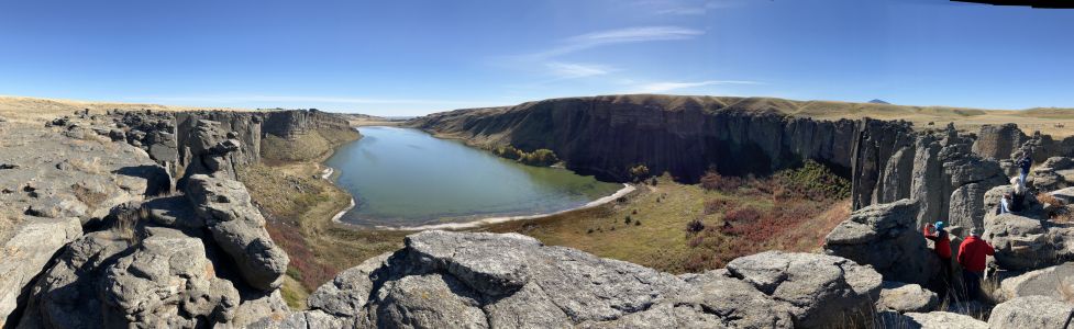
One of Montana’s other floods has been tickling the curiosity of some of our members.. This grew into a desire to plan a trip over to the upper Missouri River to see the channels from the diversion damming and outburst of Glacial Lake Great Falls. Thus, a reconnaissance was planned for 4 people. As the word got out everyone wanted to go and we wound with 14 souls on a loosely planned ‘let’s go over and see what we can find’ trip. The map below portrays Lake Great Falls when the Keewatin lobe of the Laurentide Continental Ice pushed the Missouri River out of its banks, pushing it south to the ice margin until the ice sealed off on the Bears Paw Mountains, then rapidly snaked off a sub lobe that sealed off on the Highwood Mountains. The lake began to fill to about 600 feet deep over Great Falls. It burst catastrophically at least once, creating the mile wide 500-foot deep Shonkin Sag (AKA Big Sag). This history appears to be a little more complicated than that as we turned up places where the last flood cut previous flood gravels. MBMG Special Publication 122: Geology of Montana, vol. 1: Geologic History by IAFI member DR Larry Smith is an excellent read for the details. This is a flood channel in soft rock (Cretaceous shale and sands). The lakes along the flood channels are endorheic (allows no outflow to other, external bodies of water or groundwater) so equilibrate by evaporation and are salty like the sea. The presence of these is a major clue the swale or drainage they are in is a flood channel. This is a flood channel in Shonkinite, a peculiar, dark igneous rock that would be basalt if it were not greatly enriched in potassium. Importantly it forms the columnar jointing common in basalt making it subject to plucking and the formation of retreat cataracts and geometry like the Washinton scablands. Note the column size. These are 5 to 10 feet in diameter and weigh many tens of tons but still the high surface area makes them subject to plucking if you have enough water moving quickly. We extracted a piece of Shonkinite gravel with blebs of white felspathoid syenite (like feldspar but having a different structure and much lower silica content) exsolving from Shonkinite magma like oil from water in salad dressing We stayed at Fort Benton, the historic steamship terminus on the Missouri river. Much of this is on private land and the landowner graciously allowed access to our group after being forced to close it due to trash and bad behavior. Lynne Dickman was the persistent silver tongued devil that made this happen. In all this was a very interesting reconnaissance of one of the other Montana floods. Article by Jim Shelden, President, Glacial Lake Missoula Chapter of Ice Age Floods Institute
Field Trip to Dam Site

A field trip to Sandpoint ID to visit geologic sites related to the ice dam(s) that blocked the Clark Fork River and caused the formation of Glacial Lake Missoula multiple times is planned by the Glacial Lake Missoula Chapter in cooperation with Tony Lewis of the Coeur de Deluge Chapter. An all day bus trip is planned for April 18th followed by a car caravan to Farragut State Park and other downstream sites the next day. Registration for the event is limited and is being handled by the Montana Natural History Center at https://events.humanitix.com/ice-dam-field-trip Discounted lodging reservations are available at the Schweitzer Resort until March 18th. For more information contact Sherry McLauchlan 406-207-7760.
An Old Timer (Jeff Silkwood) IAFI Story

In the early days, the IAFI and National Geologic Trail were mainly good intentions and lacking in ways to communicate how enormous and special this landscape was. Jim Shelden, then Regional Geologist for Region One of the US Forest Service in Montana and now president of the Missoula chapter of IAFI, realized a good map was necessary to galvanize action on the project and legitimize the new group Jim Shelden had just hired Jeff Silkwood in an open-ended position as a Stay in School Cartographer and Database person in 1995. Jeff had just returned from military service and was enrolled in classes at U Montana. Jeff was assigned to digitizing maps of the Beartooth Mountains and other mapping projects in the states of the Northern Rockies. But he was particularly interested in Glacial Lake Missoula and the Ice Age Floods. And he knew he had the computer skills to use existing data to put a map together. As the maps grew larger, more complex and included features like hill shaded relief and multi 1-degree by 1-degree tiles fitted together that no one else could do, it slowly dawned on Jim that this guy was really something. The only limitations were equipment – no Dept of Ag computer could handle it nor could any plotter manage the print task. In those early days this involved overcoming computer limitations on the size of files. Combining digital elevation models for multiple tiles and maps resulted in gigantic files for the times and processor’s abilities. Jeff wrote 2500 lines of code linking multiple computers, writing new code to handle the plotter problems to complete this project over about a two year time span, working on this while completing other jobs which had more firm deadlines. The basic data came from the USGS digital version of topographic maps supplemented with data from NASA satellite images. Google was working with some of the same data for use in its own maps, and there was some back and forth communication with them on how to solve similar mapping problems. Mapping issues that came up for this project included drawing a boundary for the west coast at a time when the ocean level was much lower – which had to be done by hand. And decisions about the extent of the lake and the extent of the continental ice sheet and glaciers – maximum levels and multiple contributors as to extent were used. Initial drafts were printed on a pen plotter, then the imagery was upgraded to an ink jet printer, which was subject to fading. The final map with photo images was turned into print plates by the Forest Service special Publications group in Washington. Approval for even printing the map was complicated. – it was (and still is) the only map ever printed by USFS which was more than a travel map and identified by author. An initial printing of 2000 copies was authorized – and sold out in 3 days. Another printing of 2500 was done. The USGS ordered a third printing they sold from their Denver and Spokane Libraries. It is no longer available, supplanted by on-line maps, and subsequent versions with different detail (such as highways) done by Eastern Washington University and others. A few copies of the original map still exist, and Jeff is still working on cartography for a private firm in Missoula. The importance of the original map to give IAFI credibility and as a tool to tell the story and sell the need for a special designation has never been officially recognized…until now. Thank you Jeff for your personal commitment to this project, and thank you Jim for your support in making it happen.
Erratic in the Bitterroot
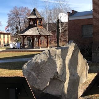
An 8 ton erratic left behind by Glacial Lake Missoula in the Bitterroot Valley on the property of a local rancher was relocated to serve as the focal point of an outdoor kiosk exhibit at the Ravalli County Museum at the former County Courthouse, 205 Bedford Street in Hamilton. Unlike their counterparts at other location along the National Geologic Trail, erratics in this part of the Ice Age Floods did not come from Canada nor did they travel as far, but the action of the floodwaters and iceberg rafts is equally evident despite more shallow waters. There are similar erratics found elsewhere in Bitterroot, on the campus of the University of Montana, and at the Bison Range. The outdoor display tells the same story as other locations on the Ice Age Floods National Geologic Trail but also includes information on two other National Park Service trails that pass through this area – the Nez Perce and the Lewis and Clark National Historic Trails. The museum has other indoor exhibits of historical interest and about Glacial Lake Missoula.