Exploring the Geology of the Gorge with Wildwood Academy

Wildwood Academy, a small alternate school in Hood River, Oregon, contacted the IAFI Columbia River Gorge Chapter with a request for a Gorge Geology presentation for their younger and older student groups. On a couple of days in November, as chapter president, I talked to the two groups from a slideshow covering the last 40+ million years of Columbia River Gorge geology, followed up by short field trips to local sites of geologic interest. As you might imagine, making an hour-long, semi-technical presentation to school kids can be a daunting experience. But these kids were tuned in, attentive, and incredibly responsive, with questions and comments that were right on target. Of course, their teachers had already touched on many elements of Gorge geology, so the kids said they felt the show’s progression through time helped bring it all together for them. And their energy in the classroom and in the field was a wonder to behold. The free-ranging atmosphere at this alternate school was eye-opening and exciting, especially for someone who grew up many years ago in a more structured public school atmosphere. But possibly more important is the feeling that the wonder and excitement of learning and experiencing the world around are alive and well in all the generations following my 75 years. Of special importance to me was a note from one of the parents, “My daughter was one of the kids you spoke to today and she has done nothing but talk about how amazing you were and how she wants to study the Columbia River Gorge area. I have heard nothing else since about 4 o’clock this afternoon!!” It’s a thrill and a real honor to have had that kind of impact.
Ice Age Floods Institute at GSA Convention

In August the Ice Age Floods Institute was offered an opportunity to share an exhibitor booth with the Tualatin Ice Age Floods Foundation (TIAFF) at a major geological conference, the October 10-13 Geological Society of America (GSA) Convention in Portland, OR. This gave IAFI an opportunity to present the Floods Story and educate a worldwide assemblage of geological professionals, researchers, and students, many of whom were not even aware of the Floods or their immense scope. The IAFI Board jumped at this opportunity, approving the registration cost and putting the booth development in the hands of the Columbia River Gorge Chapter President and IAFI Webmaster, Lloyd DeKay, aided by IAFI Membership Secretary, Sylvia Thompson, who also represented TIAFF along with Dr. Scott Burns of Portland State University. With Dr. Burns influence, we were able to acquire a corner booth space very near the main GSA area that ensured a good parade of participant traffic past our booth. We used 3D modeling software to design the booth to scale, then began assembling the materials for the booth. We used QGIS software, with assistance from Stacy Warren of Eastern Washington University, to develop a new map that highlighted the Floods paths, various glacial and temporary lakes along the floods path, as well as the final resting place of much of the sediment eroded by the Floods on the Astoria Submarine Fan. We then printed the map and other images, purchased, trimmed and covered 2” foam insulation boards for display walls, borrowed tables, made table covers, and gathered IAFI Store materials for sale. The day of reckoning came Oct. 8th, when we moved everything to the Oregon Convention Center and set it all up. The Exhibit Hall opened at 5:00pm and we began telling the story that would repeat many times over the next 4 days to people from around the world. We talked with relative locals (WA, OR, ID, MT, NV and CA), people from other parts of the US (at least AK, AZ, UT, CO, TX, AR, IA, KS, KY, IL, MN, WI, LA, GA, NC, SC, AL, FL, NJ, NY, MA, NH, VT, RI, CT), and several countries (including Canada, Finland, Holland, UK, Italy, Morocco, Zimbabwe, India, China, Australia, Columbia, Mexico, and Costa Rica). In all, there were 2,700 in-person participants this year. Our booth was one of the most popular and usually had 2-5 people at a time looking at the displays. Geologic luminaries such as Vic Baker, Richard Waitt, Scott Burns, Bruce Bjornstad and Nick Zentner also stopped by, attracting even more visitors to the booth. We gave away National Park Service, IAFI and TIAFF brochures and we sold books, maps, hats and t-shirts as well as our packets of chapter brochures. Though it involved a lot of time and work for the members and volunteers who manned the booth, we feel it was well worth the effort to educate and spread the Story of the Ice Age Floods. Many thanks to IAFI members Lloyd DeKay, Sylvia and Rick Thompson, and TIAFF volunteers Jerianne Thompson, Yvonne Addington and Linda Moholt for helping make this effort a stunning success. And we now have materials and experience that will serve well for future professional, educational and general public events like this.
Nick Zentner – More Geology Videos

Are you looking for new geology videos? Nick Zentner has done a long series live geology lectures from his home in Ellensburg and posted them online to his YouTube channel https://www.youtube.com/user/GeologyNick/videos He is now recording a series of “Nick on the Fly” virtual field trips and posting them on the same YouTube channel https://www.youtube.com/user/GeologyNick/videos Join Nick as he explores the geology of the Pacific NW and many other topics.
Use Social Distancing Time to Explore the Floods with Our Interactive Online Map
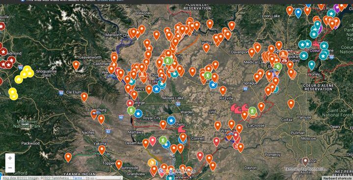
If you’ve ever tried to explore the Ice-Age Floods with a guidebook you’ll know how difficult and frustrating it can be to find and learn about the features in the area you’re visiting. Well, there’s now a solution to that problem; an interactive map that’s available wherever you have internet access. The map features over 300 points of interest throughout our 4-state area, with a description and images that slide out when you click on one of the markers. More features are being added all the time, and we’re planning to expand the map with features related to the Lake Bonneville Flood event that rampaged through the area during the time of the Ice-Age Floods. Since this is an internet-based map, it’s also easy to get driving directions to the site from wherever you are starting from. You can also easily build an informative field trip, exploring and learning about a number of other nearby features with just a few clicks of your mouse. We feel this may be the most useful field guide ever developed to explore ice-age Floods and glacial features throughout our 4-state region. AND it’s absolutely FREE! The only shortcomings we see are 1) the map requires internet access, which isn’t always available in far-flung areas of our region, and 2) we may not have every point-of-interest on the map (YET!). If we’re missing something you think is important we encourage you to submit your suggestion. We also appreciate any comments and/or corrections by email to Webmaster@IAFI.org. We sincerely hope you enjoy using this guide to poke around these fascinating ice-age features.
Explore the Ice Age Floods with 12 New IAFI Brochures

IAFI has compiled 12 brand-new, full-color brochures into a packaged set to help guide you in visiting spectacular ice-age features across all of our 11 Ice Age Floods chapter areas. With these brochures as your guides you can explore the paths of the Ice Age Floods from Montana through Idaho, central Washington and northern Oregon, and even delve into the many glacial features of northwest Washington. Click on any of the brochure covers below to see a full size printable PDF version (note: you’ll need to scale down to print on 8.5×11 letter size paper). Packets of all 12 full-size brochures are NOW available through the IAFI Store and at participating local outlets. Click a cover to open a PDF of any of the brochures below
“Gorge-ous Night Out” in Olympia
For the past four years and more, Gorge people and businesses have provided Oregon and Washington legislators and staff a casual “Gorge-ous Night Out” evening event to remind them and raise their awareness of the Columbia River Gorge. The intent of these matching events in both Salem and Olympia is not to lobby the legislators for anything in particular, but to remind them that we’re here, we’re vibrant, and we’re an economic and cultural force for both states. The IAFI Columbia River Gorge Chapter has been part of most of these events, educating the legislators about the Ice Age Floods story, and citing the economic role that Floods tourism can and does play in both local and state economies. It is somewhat surprising how few of the legislators have even visited some of the spectacular Floods sites throughout the region. So we premiered for them some of the new chapter tourism brochures we plan to release soon, and encouraged them to “get out on the road” for an awe inspiring look at the landscape and people they represent. We even agreed to requests for guided tours of Gorge geology from a couple of legislators and their staff. What better way to entertain and educate them while building a relationship that we can count on when we do need to ask them for their support.
“Hiding in Plain Sight”
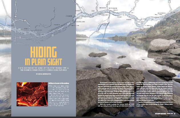
Millions of people who visit and pass through the Gorge each year don’t realize the scope of the cataclysmic stories behind the stunning and tranquil beauty they are surrounded by. The Spring 2019 edition of The Gorge Magazine (page 50) attempts to address that premise with a feature article about the geology of the Columbia River Gorge titled “Hiding in Plain Sight“. The author, Gregg Harrington, who is not a geologist, used a private tour with Lloyd DeKay, president of the Columbia River Gorge Chapter, as well as other local geologists as a basis for much of the article. The article touches on 40 million years of Gorge geology, including the Ice Age Floods, and highlights some of the more interesting geological features of this popular tourist destination. Hopefully, articles like this, along with IAFI field trips, lectures and website, will help many recognize and realize some of the tumultuous story that lies behind the enchanting scenery, and make them “never see the Gorge in the same way again”. The magazine is available online and begins at page 50. We had hoped for an Ice Age Floods Institute website mention, but a planned “For more information” section was not included in the article. Still, the article covers a lot of interesting geology of an extremely popular destination, and an article like this is a significant contribution to our efforts to inform and educate the public about the Ice Age Floods.
6 New ‘Nick On The Rocks’ Episodes
6 new short episodes of ’Nick On The Rocks’ aired on PBS this past winter! Each of these gems are short enough to be taken in by even the busiest of us, and yet have enough information to whet the appetite of even the most intensive of us. Nick is masterful in his presentations and who he draws in to help. Watch them all, you won’t be disappointed. Lake Chelan – Battle of the Ice Sheets (w/ Chris Mattinson) Click HERE to watch. 5 minutes. Chasing Ancient Rivers (w/ Steve Reidel) Click HERE to watch. 5 minutes. Seattle Fault (w/ Sandi Doughton) Click HERE to watch. 5 minutes. Bridge of the Gods Landslide (w/ Jim O’Connor) Click HERE to watch. 5 minutes. Columns of Basalt Lava Click HERE to watch. 5 minutes. Ancient Volcanoes in the Cascades (w/ Daryl Gusey) Click HERE to watch. 5 minutes.
13,000 Year-Old Human Footprints Found on BC Island
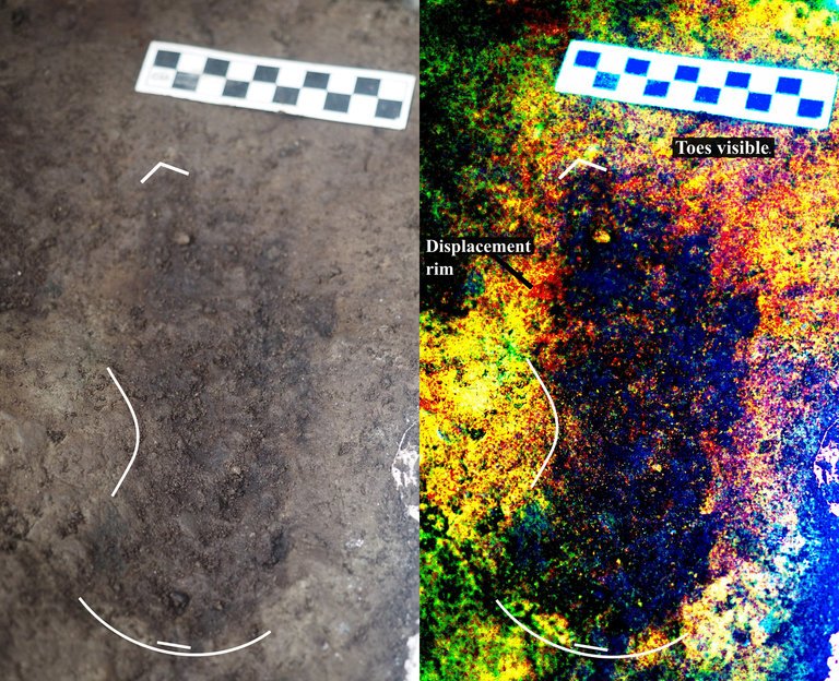
Big feet. Little feet. A heel here. A toe there. A digitally enhanced photo of a footprint found at Calvert Island, British Columbia that researchers dated to 13,000 years old. Credit Duncan McLaren Stamped across the shoreline of Calvert Island, British Columbia, are 13,000-year-old human footprints that archaeologists believe to be the earliest found so far in North America. The finding, which was published Wednesday in the journal PLOS One, adds support to the idea that some ancient humans from Asia ventured into North America by hugging the Pacific coastline, rather than by traveling through the interior. “This provides evidence that people were inhabiting the region at the end of the last ice age,” said Duncan McLaren, an anthropologist at the Hakai Institute and University of Victoria in British Columbia and lead author of the study. “It is possible that the coast was one of the means by which people entered the Americas at that time.” Dr. McLaren and his colleagues stumbled upon the footprints while digging for sediments beneath Calvert Island’s beach sands. Today, the area is covered with thick bogs and dense forests that the team, which included representatives from the Heiltsuk First Nation and Wuikinuxv First Nation, could only access by boat. At the close of the last ice age, from 11,000 to 14,000 years ago, the sea level was six to ten feet lower. The footprints were most likely left in an area that was just above the high tide line. “As this island would only have been accessible by watercraft 13,000 years ago,” Dr. McLaren said, “it implies that the people who left the footprints were seafarers who used boats to get around, gather and hunt for food and live and explore the islands.” They found their first footprint in 2014. While digging about two feet beneath the surface in a 20-square-inch hole, they saw an impression of something foot-shaped in the light brown clay. In 2015 and 2016, they returned and expanded the muddy pit. They discovered several more steps preserved in the sediment. The prints were of different sizes and pointed in different directions. Most were right feet. When the team was finished they had counted 29 in total, possibly belonging to two adults and a child. Each was barefoot. The researchers think that after the people left their footprints on the clay, their impressions were filled in by sand, thick gravel and then another layer of clay, which may have preserved them. Using radiocarbon dating on sediment from the base of some footprint impressions, as well as two pieces of preserved wood found in the first footprint, Dr. McLaren and his team found them to be 13,000 years old. That would make them the oldest preserved human footprints in North America. “It’s not only the footprints themselves that are spectacular and so rare in archaeological context, but also the age of the site,” said Michael Petraglia, an archaeologist from the Max Planck Institute for the Science of Human History in Germany who edited the paper for PLOS One but was not involved in the work. “It suggests an early entrance into the Americas.” Dr. Petraglia said the footprints also provided strong evidence for the coastal movement hypothesis and he added that they may have traveled the so-called “Kelp Highway,” a hypothesis that underwater kelp forests supported ecosystems down the North Pacific coast that helped ancient seafaring people hunt, develop and migrate. “The work is important because it shows the ‘real’ people, not just artifacts or skeletal remains,” said Steve Webb, a biological archaeologist at Bond University in Australia. “However, the footprints are limited in number and don’t shed light on activities or movement that tell us very much.” He added that future hunts for footprints should keep in mind that not everyone from this time period walked around barefoot. If anthropologists are too busy searching for soles, toes and arches, they might miss clues from those who wore animal skin shoes. Reprinted from New York Times – Earliest Known Human Footprints in North America Found on Canadian Island By NICHOLAS ST. FLEUR, March 28, 2018
ESA Maps a Lava Tube for Moon and Mars Expeditions
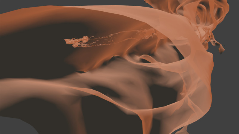
With all deference to the book and movie “The Martian”, wouldn’t you, as part of an interplanetary expedition, prefer to be protected from the radiation, micro-meteorites and extreme temperature fluctuations of the Moon or Martian surface? Though some of the hazards depicted in “The Martian” are way over-dramatized (the thin Martian atmosphere wouldn’t sustain the depicted raging storms), there are still hazards aplenty on the surface. So why not site your habitat in a cozy lava tube, protected from many of those surface nasties. At least that’s some of the reasoning behind a European Space Agency (ESA) effort to map a portion of Spanish lava tube in centimeter-scale detail as part of the ESA’s 2017 Pangaea-X campaign. Some chambers in the 8 km long La Cueva de los Verdes lava tube are large enough to hold residential streets and houses (or a prototype Martian research station/habitat). In less than 3 hours the cave research team mapped the lava tube using the smallest and lightest imaging scanner on the market and a wearable backpack mapper that collects geometric data without a satellite and synchronizes images collected by five cameras and two 3D imaging laser profilers. While the data is still being analyzed, ESA has released this ghostly fly-thru of a 1.3 km portion of the lava tube. Click the play button and prepare to take a pseudo-trip to Mars. So, the next time you visit a cave or lava tube, especially a large one, imagine yourself in a spacesuit on the Moon or Mars and realize that you’re actually an inner-space explorer. But don’t be too surprised at the creatures you may run into, they’re just other inner-space explorers too.