The Columbia River Gorge Eagle Creek Fire – Ruin or Renewal?
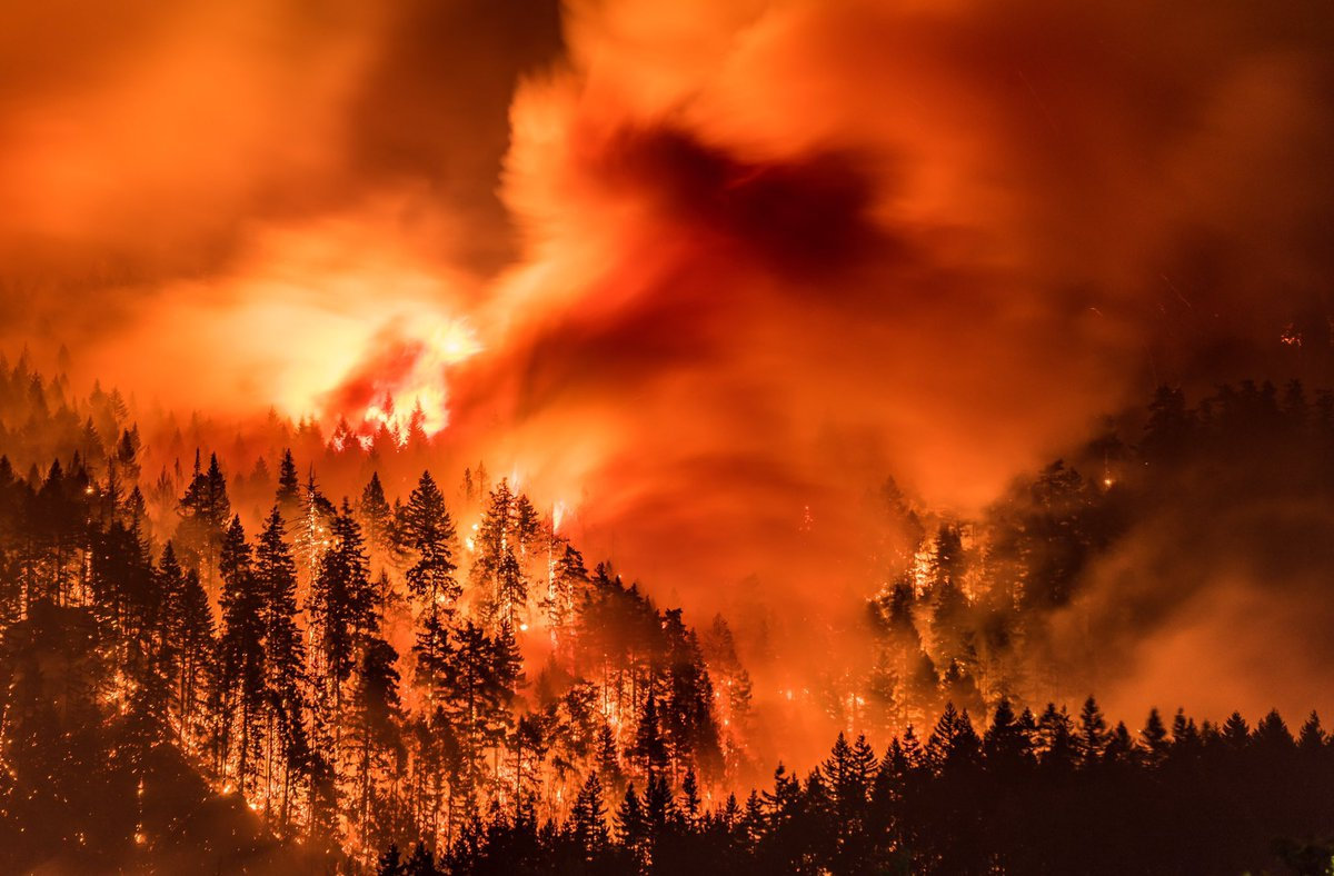
I’ve found there is huge public interest and concern about the catastrophic effects of the Eagle Creek Fire on the Columbia River Gorge. Pictures of ridgeline after ridgeline enveloped in bright orange fire, trees bursting into towering flames, and the choking smoke that filled valleys throughout the Pacific Northwest are truly a hellish image of Armageddon visited on the entire area. But, while the temporary loss of recreational trails and green forest aesthetics, and the increased potential for landslides and falling snags are inconvenient and even somewhat dangerous, the truth is that the recent fires have not ruined the natural areas of the West and the Gorge in particular, but instead have refreshed and renewed them. This past summer I’ve been interpreting geology for a new Columbia Gorge Master Naturalist Program, working beside forest ecology experts who are extremely optimistic regarding the effects of the Eagle Creek Fire. One of those experts, wildlife habitat expert Bill Weiler, writes, “Life will return to burned areas in short order. Fungi are already crawling around in the ashes of the fire, laying the foundation for soil that will support the plants that will constitute the early stage of the forest’s re-growth—a time when heat from the fire and sunlight newly reaching the ground in the absence of a canopy encourages a new crop of plants to firm up the soil structure that will allow gigantic trees to thrive. And ash is nature’s fertilizer. Plant blight, disease and insects are reduced or eliminated by burns. Mineral soil is the compost that Douglas fir seedling roots need to grow. “Dead trees” or snags are full of life.” In a typical forest fire a third of the trees will be scorched and dead, a third will be moderately to severely damaged, and a third will be essentially unscathed. Reports from the Eagle Creek Fire describe that fire as a discontinuous “mosaic burn” with much less devastation even than the typical forest fire burn. There is a broad consensus among scientists that we have considerably less fire of all intensities in our Western U.S. forests compared with natural, historical levels, when lightning-caused fires burned without humans trying to put them out. Early in the 20th century, before fire suppression became the norm, the average annual burn area in the western states was over 25 million acres, compared to a recent average of 4-6 million acres. According to Oregon State University Professor John Bailey, a century’s worth of suppressing wildfire in the United States has created conditions, especially in the West, that will ensure longer fire seasons because of longer, drier and hotter summers. Those conditions point to the need for “actively managed” forests which could include more deliberately set and managed prescribed fires. “Easily two-thirds or more of the Gorge fire is really good ecological fire,” Professor Bailey said, “the fire does some of the fuel management for us.” There is an equally strong consensus among scientists that fire is essential to maintain ecologically healthy forests and native biodiversity. This includes large fires and patches of intense fire, which create an abundance of biologically essential standing snags and naturally stimulate regeneration of vigorous new stands of forest. These areas of “snag forest habitat” are ecological treasures, not catastrophes, and many native wildlife species depend on this habitat to survive. More than 260 scientists wrote to Congress in 2015 noting that snag forests are “quite simply some of the best wildlife habitat in forests. ” Much of the Eagle Creek Fire burn area is closed to civilian activities due to the danger from flare-ups, rock slides and falling snags. The fire is less than 50% contained due to the ruggedness and inaccessibility of much of the area. Though it is still burning it is not expected to flare-up again until Winter rains and snow completely douse the embers.
Bretz and His Floods Story – National Geographic
National Geographic has published an outstanding article, “Formed by Megafloods, This Place Fooled Scientists for Decades”, about J Harlan Bretz and his outrageous, fantastical theories of a landscape shaped by huge floods. Most Ice Age Floods aficionados are generally aware of the story, but this one is so detailed and well written it’s worth reading for the story-telling value alone. Please see: This National Geographic site:
German Marshall Fund Fellows Visit Gorge Floods
On May 6th a group of 6 German Marshall Fund (GMF) Fellows from Europe and Russia got a taste of the Ice Age Floods story as they toured the Gorge, shepherded by Krystyna Wolniakowski, the Executive Director of the Columbia River Gorge Commission and a past-fellow herself. This was their last day to do some sightseeing before heading home after three weeks of intensive presentations and meetings with experienced business and political leaders. After being wowed by the scenic beauty and amazing wines of the Gorge they came to Rowena Crest for a brief discussion about the Ice Age Floods at this incredible vantage point. IAFI Gorge Chapter leader, Lloyd DeKay, used maps and illustrations and pointed out several local Floods features to help tell our story of the 1000′ deep floods that roared across the landscape and through Rowena Gap, crashing against and over this promontory on their devastating path to the sea. These Fellows came away awed by the many wonders of the Gorge, and feeling like they had the crowning experience of all the GMF groups touring the States and Europe. The GMF-funded Fellowship Program is a leadership development program intended to help build networks and develop effective transatlantic relationships and engagement for future world leaders. Each year 70+ GMF Fellows are stringently chosen from hundreds of up-and-coming business and political leaders from both sides of the Atlantic. Each small “class” is supported for 6 months of focused distance learning and 24 days of first-hand travel and experiences as they meet and learn from high-level business and political leaders. It was humbling for us to have played a small part in contributing to the experiences of this dynamic group of future world leaders.
Washington’s Ice Age Floods – ESRI Story Map
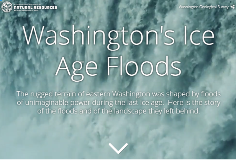
The Washington Geological Survey (formerly the Division of Geology and Earth Resources) has just released an ESRI story map about the Ice Age Floods in Washington. The story map: “tells the story of cataclysmic outburst floods that shaped the landscape of the Pacific Northwest during the last ice age. With imagery, maps and video, this story map follows the devastating deluge of the Missoula floods as it tore across the landscape, from its origins in western Montana to its terminus at the Pacific Ocean. Sites along the Ice Age Floods National Geologic Trail are featured, with an emphasis on flood features in Washington State.” Entitled Washington’s Ice Age Floods, it is best viewed on a desktop or laptop computer. Mobile devices will not show all of the content. It is navigated by scrolling your mouse through the slides. There are a few animated sections that may take a second or two to load. [weaver_iframe src=’https://wadnr.maps.arcgis.com/apps/Cascade/index.html?appid=84ea4016ce124bd9a546c5cbc58f9e29′ height=600 percent=100]
Ice Age Floods Facebook Page
You may want to ‘Like‘ the Ice Age Floods Institute Facebook page to stay abreast of all the News and Shares coming out from the Institute. We’re sharing news and articles well beyond the Floods, including geology, natural history, general articles about the area, videoed talks, events, and any number of articles of general interest. Floods of water, floods of lava, rockin’ rocks, 2-Minute Geology, paleontology, and the mystical birth of the universe all get their 15+ seconds of fame. We’ll keep our eyes open to find and share items of interest to you, and of course you can share with us too.
Palagonite Maar Near Hood River
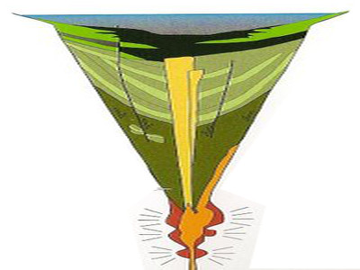
Palagonite Maar Just west of Hood River is a distinctive, short (<500 m) section of stratified orangeish oxidized volcanic tephra and highly fractured lava bombs. This mixture of oxidized volcanic particles ranging down to sub-micrometer sizes mixed with the larger lava bombs is a palagonite tuff. This deposit is the result of a “phreatic” eruption when lava erupted explosively from a volcanic vent through water, like a lake or groundwater. The rapid heating expansion of water to steam blew the rising lava out of the vent as tephra (volcanic rock fragments) ranging from ash-size to volcanic bombs (blobs of lava) up to several inches in diameter. Rapid oxidation of the water-quenched tephra turned the iron content to rust, producing the orangeish color of the tephra. The lava bombs were heavily fractured due to rapid cooling of the blob as it came in contact with the water and as it flew through the air. The tephra deposits dip inward on either side of a central gap toward the gap, with NE dips in the western section and NW dips in the eastern section, forming an inverted cone that converges downward toward the central gap. This feature is a “maar” deposit; an inverted cone of tephra and lava resulting from rapidly rising magma interacting with groundwater causing a steam-driven explosive eruption that builds the surrounding maar. The vent of this maar was in the area of the central gap.
IAFI at Gorge Tourism Studio
The Columbia River Gorge and Lower Columbia Chapters of the Ice Age Floods Institute recently participated in several Gorge Tourism Studio workshops and events intended to bring businesses, organizations, and individuals together to address Columbia River Gorge area tourism issues. The Columbia River Gorge is a unique tourism destination and scenic location. However, this destination is facing increasing challenges including congestion and overstressed infrastructure in many locations and extreme under-utilization and neglect in many others. Given the State and National significance of this destination, the Tourism Studio was designed to provide a unique opportunity for local stakeholders to develop creative solutions to the challenges facing this destination. The Studio was organized by Travel Oregon, and through a unique bi-state arrangement it included representatives from both sides of the Gorge. The Studio comprised 6 full-day workshops and 6 evening get-togethers addressing: Identifying major tourism issues and developing a vision for what Gorge tourism should look like Culinary & Agritourism – addressing farm-to-table issues of local farms, vineyards, orchards, and restaurants Cultural Heritage Tourism – addressing issues affecting the arts, culture, and heritage sectors Adventure Travel & Outdoor Recreation – addressing issues affecting the outdoor recreation and adventure sectors Tourism Marketing & Communications – learning how to create effective tourism marketing and communications Igniting Tourism Action Teams – developing Action Teams to push forward on solutions to the issues The ultimate intent is to establish a long-term sustainable balance in the utilization of the available resources and in the economic development of the area. There are likely to be many lessons and approaches developed out of these Action Teams that can have significance for addressing similar tourism issues throughout the widespread extent of the Ice Age Floods story. COLUMBIA RIVER GORGE What the Columbia River Gorge should look like in 15 Years – a Vision for Sustainable Tourism The Columbia River Gorge region including the nationally recognized Columbia River Gorge National Scenic Area and the majestic Cascades Range of Mt. Adams (12,281 ft.) and Mt. Hood (11,249 ft) within which it’s nestled, offers our target visitor a world-class adventure travel experience. While the mighty Columbia River is its defining feature, nationally designated Wild and Scenic Rivers are the life blood of the region. The Sandy and the Deschutes Rivers flank its east/west boundaries while the White Salmon, Klickitat and the Hood River carve pathways from the Cascades. Free flowing whitewater draws in the adventurous whitewater soul, skilled fishermen and most importantly, salmon. This transition zone from rainforest to desert creates nuclear winds making the Gorge one of the world’s most sought after destinations for windsurfing, kiteboarding and technical sailing. Access to snow sports abounds on the peaks including year-round skiing on the Palmer Glacier. The region’s paved, gravel, and single-track terrain provide bicyclists with a flight-like, captivating experience of the scenic landscape. Signature trails including Gorge Towns to Trails, the Historic Columbia River Highway State Trail and the Pacific Crest Trail are significant draws to the region. These trails that connect waterfalls, world-renowned wildflower meadows, basalt bluffs and the Gorge’s charming towns are frequented by hikers, cyclists and trail runners alike due to the world-class experience that they provide. [TRANSPORTATION] Our seamlessly integrated region-wide transportation system allows visitors to come, travel, explore and connect– all without needing a car. Public and private transit options combined with our bike routes and trail systems have created a multi-modal web knitting together our communities, attractions and outdoor recreation. The region is vibrant with visitation, and traffic congestion is a thing of the past. [CULINARY/AGRICULTRE] The Gorge with its concentration of locally-owned boutique vineyards and small farms boasts an abundant and rich local food scene. Locals and visitors alike can easily eat what’s grown and produced here and visitors are welcomed by growers to have meaningful, quality on-farm experiences. Restauranteurs are well-connected with local growers adding value to locally produced ingredients and offering memorable foodie experiences. The visitor industry has helped contribute to alleviating hunger in the region. [CULTURE] The ‘Gorge Experience’ is unparalleled due to its exposure to history and culture. Locals in the Gorge’s charming communities help travelers gain a deep understanding of peoples who have inhabited the Gorge in the past, of people who reside here now, and of the natural and human forces that have shaped and reshaped the landscape. Stories of this powerful place, both cultural and natural, are infused into every element of the traveler experience. Local guides help travelers personalize and deepen their own connection to the place and an unusual and rich array of classes and events to experience local culture exist. Trails of national historic significance including the Lewis & Clark National Historic Trail, the Ice Age Floods National Geologic Trail, Historic Columbia River Highway State Trail and the Oregon Trail also bring the region’s history to life. [SEASONALITY/CONGESTION] Our intuitive visitor information system has reduced congestion, and spread the benefits to all corners of our region. We have effectively targeted the high-value visitor who appreciates the outdoors and local culture, is sensitive to their surroundings and enjoys people-powered activities. Visitors are coming year-round and staying multiple days. [BALANCE] We have found balance and offer an unforgettable visitor experience while preserving our unique living ecosystem of people, culture and nature. Local residents live in a harmonious and symbiotic relationship with our environment and with the people who travel from around the world to experience a slice of life in the Gorge.
IAFI Gorge(ous) Night Out in Salem & Olympia
Columbia Gorge Chapter of IAFI has joined the party It’s easy to see what makes the Gorge a spectacular experience to visitors, but what makes it special to those who live here, work here, and raise our families here? What parts do we play in the larger economic and political fabrics of the states and nation we’re part of? One Gorge (a young Gorge advocacy group) is trying to share who we are and why we matter at the state and national levels, and to promote the big infrastructure factors to help the Gorge community excel. To help our states of Oregon and Washington to better understand and recognize the who, what, and why of interests in the Gorge, One Gorge has worked with Gorge legislators to organize a 2nd annual Gorge(ous) Night Out for Oregon legislators in Salem, and a first-time event with Washington legislators in Olympia. These casual events bring a selection local businesses and organizations sharing products and information together with legislators just to make them more aware of the vibrancy of the Gorge. We’re bringing Columbia Gorge(ous) Geology and the Ice Age Floods to these parties. Two new 40″ x 60″ displays were finished in time for the Salem event on Feb. 3rd and they were extremely popular. Some suggested we were second in popularity only to Insitu UAVs, but we were also located immediately adjacent to the food table, so factor that into the popularity poll. Now everything is ready and tested for the Olympia event on Feb. 9th for Washington legislators, and we’re hoping to build some support there for the Ice Age Floods National Geologic Trail that is focused to a large extent on Washington. Although the main purpose of the Ice Age Floods Institute usually appears to be for education, outreach, and research, it is important to realize that we also have a strong advocacy role to play. When you support the Institute you are also a player in all our education, outreach, research, and advocacy efforts. Thanks to all for your support.
Pillow Basalt and Palagonite – Lava Flowing into Water

Pillow basalt and palagonite are the result of lava flowing into water. We have a striking example in the Columbia River Gorge at the intersection of Hwy 30 and US 197 at the east end of The Dalles. This video gives a good idea of how these basalt pillows form and what they look like.
Columbia Gorge Geology in 22:22 Minutes

This video by Tom Foster and Nick Zentner about the Columbia River Gorge features an incredible variety of geology and human history as it slices through the Cascade Range of the Pacific Northwest. The Columbia River Basalts, the Missoula Floods, the Bonneville Flood, the Bridge of the Gods, Celilo Falls, Multnomah Falls, Beacon Rock, Lewis and Clark, the Oregon Trail, the Columbia River Highway, and more!