Krystyna Wolniakowski – Volunteer Extraordinaire for Columbia River Gorge Chapter

It’s not every day you meet someone whose passion for conservation spans from local community efforts to international environmental policy. Krystyna Wolniakowski is one of those remarkable individuals, and the Columbia River Gorge Chapter is incredibly fortunate to have her as a dedicated volunteer. A Local Champion Krystyna is always ready to lend a hand, whether it’s a big project or a small task. She was a vital part of the team, alongside IAFI Membership Manager Lorrie DeKay and IAFI Store Manager Patty Hurd, that brought our “Gorge-ous Gathering” IAFI Membership Meeting to life last May. Beyond specific events, Krystyna is a trusted advisor, offering invaluable insights and feedback on many of the IAFI and Gorge Chapter initiatives. Her dedication to our local efforts is truly inspiring. A Lifetime of Impact Krystyna’s impressive background in environmental conservation and public service is evident in everything she does. As the Executive Director of the Columbia River Gorge Commission, she plays a crucial role in safeguarding the breathtaking scenic, natural, recreational, and cultural resources of the Columbia River Gorge National Scenic Area. Her commitment to environmental stewardship extends far beyond the Gorge. She currently chairs the Klamath River Foundation, leading a successful multi-year project to remove dams on the Klamath River in southern Oregon—a monumental undertaking for river restoration. Krystyna is also a key member of the Romania Foundation, dedicated to developing sustainable tourism in Romania, and she contributes to the One Fly Foundation, which supports river restoration and fisheries health. Global Reach Krystyna’s career highlights showcase over 35 years of dedicated work in nature and landscape protection across the globe. Before her current role, she headed the Western Regional Office of the National Fish & Wildlife Foundation (NFWF) in Portland, overseeing conservation grant programs across seven northwestern U.S. states. From 1991 to 2000, she served as Director for Central and Eastern Europe at the German Marshall Fund of the U.S. There, she developed crucial environmental, economic, and democratic programs in numerous countries after the fall of the Berlin Wall. A standout achievement was her initiation of the Environmental Partnership for Central Europe (EPCE) program in 1990. This pioneering non-governmental grant program provided vital support to pro-ecological civil society organizations in Central Europe, including the Partnership for Environment Foundation in Poland. Krystyna Wolniakowski’s tireless efforts, both locally and internationally, exemplify a profound commitment to protecting our planet’s natural treasures. We are incredibly grateful for her contributions to the Columbia River Gorge Chapter and her enduring legacy in conservation.
Volunteers Help Shape the IAFI!

We’re reaching out to ask for your help. As we work toward our mission of promoting public awareness and education about the Ice Age Floods, our chapters have been facing a significant challenge: a shortage of active member volunteers willing to step into leadership roles or assist with essential chapter functions. Many of our current leaders are in their 70s and 80s, and the demands of their roles are becoming challenging. While our dedicated leaders works to maintain our organization’s momentum, we need support to ensure our continued growth and success. Your involvement will be crucial in helping to: Organize events: Assist with planning field trips, chapter functions, and speaker series. Provide administrative support: Help with recordkeeping, website updates, and newsletter contributions. Engage with the community: Connect with local schools and media outlets to spread awareness about our mission. Contribute fresh perspectives: Share your ideas and expertise to help us adapt to a changing world. Here are some ways you can get involved: Volunteer for events: Help plan and execute field trips, workshops, and conferences. Join a committee: Contribute to our leadership team and help make important decisions. Share your expertise: Offer your skills in areas like marketing, communications, or technology. By becoming more involved, you can: Strengthen your chapter: Contribute your time and skills to make your local chapter more vibrant and effective. Share your knowledge: Bring new ideas and contemporary skills to our organization. Support the organization: Help IAFI achieve its goals and become the foremost provider of Ice Age Floods information. No matter your level of experience or commitment, we welcome your participation. Whether you can volunteer a few hours a month or are interested in taking on a leadership role, your involvement will make a significant difference. The involvement of many will lighten the load on the few, and also bring a much-needed infusion of energy and fresh perspectives. We believe that by working together, we can strengthen our organization and better serve our mission of promoting public awareness and education about the Ice Age Floods. Your participation is essential. To get involved, please contact your local chapter through the IAFI.org website
Unearthing the Secrets of Spokane Valley: A Recap of the IAFI June Jamboree
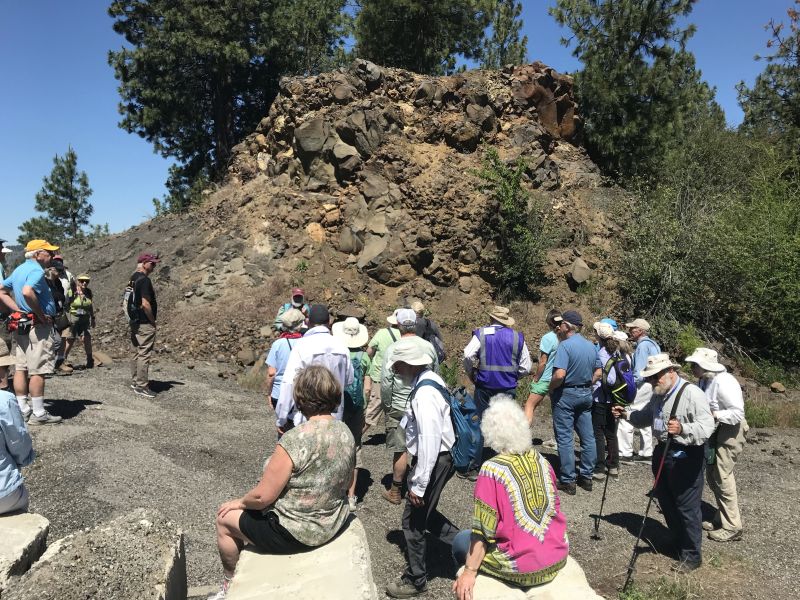
This year’s IAFI June Jamboree delved into the fascinating geological history of Spokane Valley, contrasting it with the iconic Grand Coulee and Dry Falls, explored during last year’s Jubilee. Challenging the Landscape: Unlike the open spaces of Dry Falls, Spokane Valley presented a unique challenge – showcasing evidence of Ice Age Floods within an urban environment. Our chapter tackled this brilliantly, organizing hikes and car caravans departing from convenient public parks and commercial areas. Evening Explorations: The program’s highlights included captivating lectures. Professor Emeritus Dean Kiefer shed light on J Harlen Bretz’s Spokane associates, while renowned naturalist Jack Nesbit brought the story of the first Columbian Mammoth discovered near Latah Creek in the 1800s to life. Celebrating Success: The Jamboree culminated in a relaxed gathering at Mirabeau Meadows. Registrants, leaders, and participants exchanged insights and experiences, with a resounding appreciation for the chapter’s efforts. Comparisons were drawn, highlighting how our Spokane Valley exploration continued the excellence of the Puget Lobe’s outing at Dry Falls last year. A Delicious Finale: The grand finale was a catered Longhorn Barbecue overflowing with delicious food. Everyone left satisfied, with many even taking home doggie bags to savor the flavors afterward. Check out more images from the event in this Google Photo Album. Meet the Masterminds: Linda & Mike McCollum: This dynamic professor emerita and a research geologist duo co-led tours and car caravans, sharing their latest research on the Spokane area’s Ice Age Floods, and shaping the Jamboree’s theme. Michael Hamilton: A gifted geologist, Michael led hikes and the bus trip, encouraging questions and offering honest answers. Don Chadbourne & Chris Sheeran: Don, the chapter treasurer, managed logistics with expertise, while Chris, our media and registration guru, ensured a smooth experience. Melanie Bell Gibbs: A past president and national board member, Melanie oversaw participant check-in and badge distribution. Dick Jensen: Dick handled bus transportation and provided crucial support throughout the Jamboree. Jim Fox: The chapter vice president secured speakers and offered his assistance wherever needed. We also owe a great deal to the participant volunteers who proved invaluable in assisting us in all our efforts. Through the combined efforts of many the IAFI June Jamboree was a resounding success, fostering exploration, education, and a deeper appreciation for the Spokane Valley’s unique geological heritage. Being present with so much information and conversation among such extensive expertise was to witness the scientific process in action. Meeting people from other chapters was particularly nice, putting faces with names we know. We all learned a lot.
Scabland – The Movie, A Google Earth Odyssey

“Scabland” – the Movie, A Google Earth Odyssey “Scabland” is a media complement to CWU Professor Nick Zentner’s 2023-2024 A-Z YouTube geology series that re-treads the ice age floods and the work of Professor J Harlen Bretz and others. In this short animation, viewers virtually fly to a selection of locations visited by geologist Dr J Harlen Bretz, with quotes from his original field notes, geolocated in Google Earth and animated with Google Earth Studio. To see more of these locations, visit https://www.geology.cwu.edu/facstaff/nick/gBRETZ/ This video was done as an experiment/prototype by the authors, Glenn Cruickshank and Eric Larson, to showcase Google Earth, virtual special effects techniques, some of the spectacular landforms caused by the floods, the impacts of ice and water during the Last Glacial Maximum and the field locations of J Harlen Bretz. Eric Larson in Billings MT runs Shashin Studio, a VFX video production company (contact@shashin.studio). Google Earth Glenn is a retired photojournalist and consultant in Liberty Lake WA. Credits: Glenn Cruickshank Eric Larson Two Steps From Hell Made with Google Earth and Google Earth Studio. Thanks to The Families of J Harlen Bretz and Thomas Large, Nick Zentner, Glenn Cruickshank, Bruce Bjornstad, The Ice Age Floods Institute, and many others.
Lyle Cherry Orchard Interpretive Panels Installed
Last week, Friends of the Columbia Gorge completed installation on their first-ever interpretive trail signs at the Lyle Cherry Orchard Preserve! They’ll be sharing MUCH more on this story in spring 2024 (including guided outings!), but if you’re intrepid enough to hike this trail during the winter, check out the brand new signage with QR-code links to learn more about the preserve and the Gorge. Stay tuned for more in the coming months. And check out the Ice Age Floods geology recording.
Let Your Feet, and Your Imagination Roam at Rowena Crest and Tom McCall Preserve

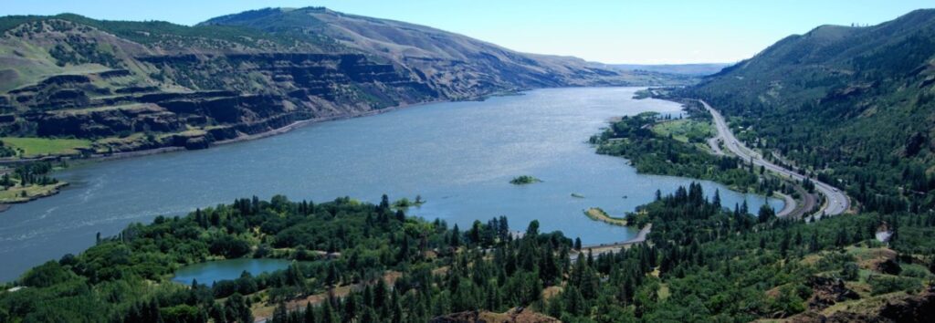
Scenic Rowena Crest and the Tom McCall Preserve area provide an incredibly scenic place to let your feet, and your imagination wander as you look out on a major chokepoint along the Ice Age Floods path. The wildflower displays are amazing during the Spring, but several compelling flood-related features are visible from the vantage of the Rowena Crest Viewpoint any time of year. Rowena Crest lies nearly 700 feet above the Columbia River at the upstream end of the Rowena Plateau, a miles-long plateau that the river flows along. Just upriver from the plateau is the narrow section of the Gorge known as the Rowena Gap The drive to the viewpoint on old Hwy 30 from either east or west is a spectacular ride through a wonderous section of the Columbia River Gorge. A roundabout parking area at the viewpoint, with a safety wall above a sheer cliff, provides a great observation point eastward toward Rowena Gap. At Rowena Crest it’s easy to imagine what it might have been like to witness the approach of those massive floods. There is not yet scientific evidence that humans were in the area to bear witness to the Ice Age Floods, but there is solid evidence of humans in the Americas by that time. And there is growing concensus that if they came in during a glacial maximum, they would have come in by a coastal route that offered plentiful food and shelter for their journey. The mouth of the Columbia River would have been the first major waterway path inland that might have led them to settle in the area of the Floods. Your village might have been situated across the Columbia at the mouth of the Klickitat River where the town of Lyle now sits. If you were foraging, or just relaxing, atop Rowena Crest on a late summer day, you might have felt the ground begin to temble as if there were a small earthquake, but the trembling would have slowly increased for a few hours. Eventually you would have heard a low roaring sound that also grew over an hour or more before you could see turbulent brown muddy water begin flooding across the broad basin to the east. Then the roaring flood of water, only a few feet deep at first, would have entered the narrows, now called Rowena Gap, and sped on, crashing against the promontory you’re standing on and being diverted toward your village which was quickly washed away by the muddy torrent. But the muddy flood waters would have kept rising, unlike the Spring floods you’re used to on the Columbia, becoming a hundred feet deep, then two hundred as the levels just kept rising. Soon a huge whirlpool formed in the flood waters near the base of the promontory and a giant eddy formed where your village had been as flood waters flowed backward up the Klickitat River even as the bulk of the water continued downstream on the main stem of the Columbia. As the flood waters reached 400 and 500 feet deep and kept coming, suddenly to your right and left, huge blocks of the promontory broke off and slumped down into the rampaging flood waters. Now, even more fearful, you would have begun running south toward higher ground, climbing higher and higher as the still rising flood waters poured across the plateau and plunged into the small creek valley to the west, tearing away at the valley walls and massively widening that little valley. Eventually the flood waters stopped chasing you upward as you climbed higher, 200 then 300 feet above the now submerged promontory. Now, as you turned and looked out across that expanse of muddy water you could see massive white blocks of ice being carried along on the flood waters, similar but inconceivably larger than the ice blocks carried on the river during the Spring floods. But the flood waters didn’t begin to recede that day, nor the next, as they might in the Spring floods. In fact it was almost half a lunar cycle before they began to slowly recede, exposing a mud coated Columbia River valley that was now noticeably wider, with layers of shear vertical rock walls extending over 1000 feet above the normal river level below. As you began the recovery from the floods devastation, your family returned from from their hunting and gathering in the high mountain meadows, and you have an incredible story to pass along to them and your ancestors. This story is easy to imagine as you look out to the east from Rowena Crest. The onrushing Ice Age Floods waters easily flowed over the low relief of the broad Dalles Basin to the east, but the major Rowena Gap created a chokepoint in the path of the floods as they made their way through the Columbia River Gorge. This “hydraulic dam” forced the flood waters to build to over 1000 feet deep in this area, flowing hundreds of feet deep over Rowena Crest while forming a temporary lake in The Dalles basin. It is estimated that many of the 40-100 Ice Age Floods may have taken up to a month to completely flush through the system to the Pacific Ocean, but the duration of the flood waters at any point along the path probably lasted less than a couple of weeks. But this was more than enough to create several major floods features visible from this vantage point. At Columbia River level below and east of the promontory is a round Kolk pond that was created by giant whirlpools in the flood waters as they were deflected around the Rowena Crest promontory. Other similar Kolk features can also be seen on the Dallesport area to the east, and along the hiking path atop Rowena Crest where they are marked by surrounding groves of oak trees. Across the Columbia, the floods deposited a huge eddy gravel bar that the entire town of Lyle, Washington is built upon. The Klickitat River was backed
Mima/Desert/Biscuit Mounds – An (Possible) Explanation

If you’ve visited the Rowena Crest Viewpoint at Tom McCall Preserve, west of The Dalles in the Columbia River Gorge, you may have noticed the many dome-shaped earthen mounds that cover the Rowena Plateau. These mounds are broadly circular and are surrounded by collections of basalt rock fragments. If you’ve visited the spring wildflower mecca of Catherine Creek on the Washington side of the Gorge, you may have also wondered at what caused the stripes of black rock extending down the slopes above the area. Tens of thousands of similar soil mounds cover large areas of the high desert lands of north-central Oregon, often in swarms that number in the hundreds. These mounds can be round or elongated, can range from a dozen feet to more than 60 feet in diameter atop the rocky Columbia River Basalt bedrock, and are typically surrounded and separated from each other by rings or stripes of basalt rock fragments. The mounds also appear similar to those at Mima Mounds Natural Area Preserve near Olympia, WA. There have been many suggested causes for the creation of these mounds, from burial mounds, to Pleistocene pocket gophers, to plants or glacial sun cups trapping wind-blown sediment, to sorting by earthquake vibrations, to turbulence at the base of ice-age floods flowing over the landscape. Research by two Oregon graduate students, Clark Nelson of Oregon State University and John Baine Pyrch of Portland State University, independently came up with what may be the most likely explanation for the origins of these enigmatic features. Their theses suggest desert mounds and their rock rings formed through a process of natural sorting, where fine soil material is pushed up into mounds and associated rocks are pushed out to the edges to form rings through countless cycles of wetting/drying and freeze/thaw during the wetter and colder period of the late Pleistocene. Clark Nelson cut a trench through a mound that exposed layers of soil and volcanic ash whose lack of mixing discounts the pocket gopher theory. Nelson also found that slope angle less than or greater than 10 degrees determined whether the features would form rounded mounds vs. elongated stripes. Pyrch showed the strips to be distinct from common talus slopes, because no obvious source of rock exists at the head of the talus stripe. He also observed that rocks within these stripes are sorted, unlike talus slopes, suggesting the same ice age freeze-thaw origins as soil mounds and rock rings. You can read more detailed articles about these enigmatic features in these articles: Mystery of the Desert Mounds Great Pyramids of the Gophers: Mima Mound Mystery Solved Similar processes are also thought to be responsible for the “patterned ground” found in periglacial environs. However these various types of features may have formed, we can be certain how the few mounds in the center of the parking circle at Rowena Crest Viewpoint came to be. They were man-made during the construction of the viewpoint and made to look like the mounds that cover the Rowena Plateau. At least one origin has a definitive answer.
Grand Coulee Field Trip
Grand Coulee Field TripExploring the Ice Age Floods and Geology of the Grand Coulee AreaGrand Coulee Field TripExploring the Ice Age Floods and Geology of the Grand Coulee AreaGrand Coulee Field TripExploring the Ice Age Floods and Geology of the Grand Coulee AreaGrand Coulee Field TripExploring the Ice Age Floods and Geology of the Grand Coulee AreaGrand Coulee Field TripExploring the Ice Age Floods and Geology of the Grand Coulee AreaGrand Coulee Field TripExploring the Ice Age Floods and Geology of the Grand Coulee Area Click here to download, complete and print a Liability Waiver required of all attendees The Grand Coulee system is a geologic wonderland created by the ice-age interplay of geology, ice and massive floods. In a 2+ day (Sept 19-20 +) car-caravan field trip we will explore many of the unique features leading to and resulting from that interplay. Prepare to have your minds blown. Click Here for the field trip guide. Since this is our first Grand Coulee field trip, please bring a copy to help keep us on track.Please note: the sequence of days and route directions may be changed to adjust for scheduling issues. Dry Falls Plunge Pool – Ominski Grand Coulee at Steamboat Rock Dry Falls Lake Dry Falls Channeled Scabland – Bjornstad Field Trips Upper Grand Coulee Field Trip Car Caravan Lake Lenore & Great Blade – Bjornstad Northrup Cnyn Flood Deposits Million Dollar Mile, Upper Grand Coulee Ranger David McWalter Monster Rock – Ephrata Fan Grand Coulee Dam Steamboat Rock Sunset Local Lodging Information There are multiple quality lodging options available in the area, from campgrounds, motel and hotel rooms to fully furnished cabins with kitchens. Book lodging reservations using links below. Sun Lakes – Dry Falls Camping/Cabin options Lodging on site at Sun Lakes – Dry Falls State Park Sun Lakes – Dry Falls State Park: standard tent & RV campsites can be reserved through WA.Parks.gov. Availability may be limited. Campsite fees: Standard $20-$30, Partial utility $30-$40, Full-utility $35-$45 Sun Lakes Park Resort: adjacent to the state park, standard tent & RV campsites and fully furnished cabins with kitchens (maps). Other Local Lodging options Local inn & hotel lodging options Best Western Rama Inn: Motel rooms in Ephrata (26 minute drive to Sun Lakes State Park) Soap Lake Spa and Resort: Motel rooms in Soap Lake (23 minute drive to Sun Lakes State Park) Masters Inn: Motel rooms in Soap Lake (23 minute drive to Sun Lakes State Park) BW Rama Inn Soap Lake Resort BW Rama Inn Lobby Soap Lake Resort Cabin BW Rama Inn Room Soap Lake Resort Room BW Rama Inn Breakfast Soap Lake Resort Restaurant BW Rama Inn Pool Soap Lake Resort Jacuzzi BW Rama Inn Sauna Blue Lake Resort: Cabins (four minute drive from Sun Lakes State Park) Sun Village Resort: Cabins, RV sites (four minute drive from Sun Lakes State Park) Banks Lake Lodge: Basic motel rooms, cabins, RV sites (six minute drive from Sun Lakes State Park) Ala Cozy Motel: Basic motel in Coulee City (six minute drive from Sun Lakes State Park) Local Dining Information Dining options range from excellent restaurants to local pubs and burger joints. Here are a number of simple to hearty dining options: Sun Lakes Park Resort (adjacent to the State park): Duke’s Diner: takeout window serveing breakfast sandwiches, coffee, espresso, burgers, sandwiches, hotdogs, shakes and smoothies. Multiple restaurants in Coulee City (six minute drive from the State Park) Multiple restaurants in Soap Lake (spectacular 23 minute drive from Sun Lakes State Park) Multiple restaurants in Ephrata (spectacular 26 minute drive from Sun Lakes State Park) Multiple restaurants in Grand Coulee (spectacular 37 minute drive from Sun Lakes State Park)
Lyle Cherry Orchard Trail Geology Recording
The Lyle Cherry Orchard Trail is a moderately strenuous trail being developed in the Columbia Gorge by Friends of the Columbia Gorge. They envisioned having a number of interpretive stations along the trail to inform and educate trail users. A station could focus on a single topic, such as the geology, plants, animals, indigenous and cultural history of the area. But they found that the cost of interpretive signs would be prohibitive, would be expensive to maintain and might not last long. So they started brainstorming for better ways to realize thier vision. The came up with a plan to place trailside posts, resembling basalt columns, with a QR code the user could scan with their smartphone that would connect to an informative recording about that location. Friends hopes to have the trail work and information stations finished by 2024. Then everyone will be able to experience the beauty along the Lyle Cherry Orchard Trail with a deeper understanding of their surrounding through the recordings. Renee Tkach, a Friends coordinator of the project, contacted Lloyd DeKay, president of the IAFI Columbia Gorge Chapter, about doing a recording for the first station about the geology of the area. They took a very windy hike together on the still somewhat challenging trail to the first station, where they talked about the focus of a recording and took a number of photos to document the views. At home Lloyd developed a script that everyone reviewed and agreed upon. Then began a few frustrating hours of recording and editing to produce a 4:30 minute recording. Since the original plan was for a 3:00-3:30 minute recording, Friends will now review the recording and decide if it’s OK or needs to be shorter and where to cut back. This method may also be an easier, economical and useful way to provide information at other floods sites throughout the region. Significant advantages include the relatively low cost and long life of the information station, and ability to provide both video and audio clips for a number of features on a webpage linked to the QR code, and the ability to modify and update the presentations as new or updated information becomes available.
Explore the Columbia River Gorge
The Columbia River Gorge is an incredibly popular area to visit, and that’s for good reason, the setting is uniquely spectacular. The Gorge encompasses: Easily accessible ecozones that range through boreal conifer forests, oak woodlands, high desert grasslands and alpine environments in only 40 miles, Dazzling viewpoints and scenery, including beautiful waterfalls that cascade over the high basalt ramparts that bound the relatively narrow Gorge and the majestic Columbia River running through it, Mt. Adams, Mt. St. Helens and Mt. Hood, imposing snow-covered stratovolcanoes lying less than 40 miles north and south of the Gorge, Picturesque small towns that are bounded by extensive federally- and state-protected natural areas throughout the length of the Gorge, Abundant recreation opportunities including hiking, road/mountain biking, windsurfing and kiteboarding, whitewater kayaking and rafting, fishing, hunting, alpine/cross-country skiing and snowshoeing, Numerous award-winning wineries and breweries, restaurants and pubs, shops, galleries, museums, parks, hotels and campgrounds, And all this is lying at the back doorstep of Portland, Oregon. The Gorge is also a geologic wonderland, exposing stories about: The 40 million year history of the Columbia River, The series of massive Columbia River Basalt flows 18-12 million years ago, The rise of the Cascade Mountain Range since about 5 million years ago, The passage of numerous, up to 1000 feet deep Ice Age Floods that reshaped the Gorge 18-14 thousand years ago, Tectonic faulting and folding, landslides, earthquakes, forest fires, and The often intertwined lives and stories of the people who have lived here. Of course, with all this bounty the area is also a robust tourist mecca, which can mean limited accommodations for summer crowds. Most attractions are easy to drive to, but bus tours and river cruises are also available. Due to the popularity, some of the iconic attractions now seasonally restrict vehicle access and require permits.