Relive Important Archive Articles

A large number of important articles get buried over time as new articles are added to our website, so here’s a chance to review and relive some of our most important articles. We think you might enjoy reviewing these timeless features.

Earth in the Next Billion Years

No one can ever say for sure what the future will bring, but this new video has summed up all the science-backed predictions that we can reasonably make about how Earth will change over the next 1 billion years. It’s highly unlikely that anyone will be around to see most of these changes come to pass, so consider this an exclusive front-row seat to a world where supercontinents reign supreme, Mount Everest is no longer the tallest mountain on our planet, Earth enters another glacial period regardless of current global warming trends. and then the Sun becomes a lot hotter. Just another reason we should be glad we live at the time we do. Reposted from Science Alert and RealLifeLore

Read More »

Front Porch: Water etches interesting stories on landscape

I have always loved the ocean. I spent my growing-up years in, on or at least somewhere near the Atlantic Ocean and its various bays. The feel of ocean water, its movement, how it smells and all the amazing life that it supports – wonderful. And whenever I looked over the ocean’s horizon, it wasn’t scary, but rather full of potential for what was just beyond what I could see. When I moved to Spokane – clearly, no ocean, but lots and lots of freshwater lakes and rivers. I have spent I can’t tell you how many of my adulthood hours, swimming in Lake Coeur d’Alene, Lake Pend Oreille, Priest Lake, etc. And sailing. And walking along riverbanks. And tossing sticks into whatever body of water, fast moving or still, that was before me, for our dog to fetch. Water is wonderful. As a young bride, newly relocated to Eastern Washington, lo those many years ago, I took my first drive to Seattle with my husband. Heading up the Sunset Hill, passing Four Lakes, then Fishtrap, then … yikes. Where did the water go? There was a long stretch – broken up briefly by Sprague Lake and Moses Lake – of what was the thirstiest landscape I’d encountered. It wasn’t until we crossed the Columbia River and drove up and past the Vantage Grade did I begin to see deciduous trees and bigger leafy plants that suggested the rainfall amounts required to support them. It got lush and humid and wet as we drove west. We were heading to … water! I just endured that unappealing stretch of land between Fishtrap and the Columbia over a number of years driving back and forth to Seattle. Not only was it dry, it was essentially treeless. One friend of like mind said it was best just to drive through there at night because the view would be just as interesting. So much for being young and stupid. It was still kind of dry for my taste, but I began to appreciate how the sunlight hit the terrain at different times of year and in different weather conditions. It still wasn’t water, of course, but it kind of grew on me. It’s hard to live in this neck of the woods and not learn about the wonderful Columbia Basin Project that brought irrigation to east-central Washington (ah, water!), which produces amazing amounts of agricultural products for export and to feed us all. But what really sold me on that, to me, foreign scenery was back when I worked at Eastern Washington University and I met the terrific Bob Quinn, professor of geography, who loved the environs of the state’s east side with a zeal and passion I couldn’t possibly imagine. He gave me some information, and I began to read about this landscape I’d so easily dismissed – land that was scoured by massive floods some 18,000 to 13,000 years ago (the last Ice Age), floods from glacial Lake Missoula that carved out the canyons and created braided waterways now known as the Channeled Scablands of Eastern Washington. The floods were cataclysmic, with estimates indicating that 500 cubic miles of water that was 2,000 feet deep, burst forth at 386 million cubic feet per second – all headed this way, and beyond, in one darn big rushing, gushing explosion. And then it built up and did it over and over again. That’s a lot of water. I began looking at the landscape differently as I drove through, marveling at the magnificence of that creation, and saw that it has its own beauty – not to mention a heck of a back story. How ignorant of me to just have ignored all that geologic magnificence because it didn’t fit into my preferred norm. I thought about that again on our most recent drive to Seattle to visit our son. Clearly, I am no longer a young adult full of not-burdened-by-knowledge opinion and attitude, but an older person with a fair number of miles on her and, I hope, a greater realization that everything deserves a second look – and also, that a little research is also a good thing. Because I read a book and some supporting literature, I discovered things that gave me a different set of eyes with which to see a particular section of the world around me. I’m trying still, even in my old age, to keep doing that. Never too old to read a book and learn something. Or to change a mind. The Spokesman Voices correspondent Stefanie Pettit can be reached by email at upwindsailor@comcast.net

Read More »

First Peoples Ice-Free Corridor Migration to Americas Reexamined

Analysis of how long erratics have been exposed on ice-free ground in the hypothesized “Late Pleistocene ice-free corridor migration route” suggests that route was not fully open until about 13,800 years ago, and the ice sheets “may have been 1,500 to 3,000 feet (455 to 910 m) high in the area where they covered the ice-free corridor,” according to study lead author Jorie Clark, a geologist and archaeologist at Oregon State University. Clark said, “we now have robust evidence that the ice-free corridor was not open and available for the [Late Pleistocene] first peopling of the Americas.” If evidence of humans in the Americas prior to the 30,000 years ago is ultimately found, that evidence does not preclude the possibility of ice-free corridor migration before closure of the corridor. 

Read More »

Frenchman Coulee Drone Video

Bruce Bjornstad is at it again with his awesome Ice Age Floodscapes drone videos, this one from Frenchman Coulee. Watch it below and visit his Ice Age Floodscapes YouTube channel.for many more.

Read More »

Model for a Missoula Flood

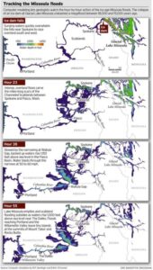
ICYMI (in case you missed it) — Floodwaters rise more than 1,000 feet as they slam into the Columbia River Gorge from the east. The torrent blasts through the narrows at 60 mph, carrying truck-size boulders and house-size icebergs. Reaching Portland, water loaded with gravel and dirt roils to a depth of 400 feet, leaving tiny islands at the summits of Mount Tabor and Rocky Butte. Geologists have spent decades piecing together evidence to tell the story of the great Missoula floods that reshaped much of Oregon and Washington between 18,000 and 15,000 years ago. Now scientists have found a way to travel back in time to watch the megafloods unfold, in a virtual bird’s eye view. Their computer simulation displays the likely timing and play-by-play action, starting with the collapse of an ice dam and outpouring of a lake 200 miles across and 2,100 feet deep. The computer model, developed by Roger Denlinger with the U.S. Geological Survey in Vancouver and Colorado-based geophysicist Daniel O’Connell, is filling gaps in scientific explanations of the floods and the baffling landforms they left, including the fabled Channeled Scablands — scars hundreds of miles long cut into the bedrock of eastern Washington and visible from outer space. The simulations also may help settle a lingering scientific controversy about what caused the repeating ice-age catastrophes. “It’s just really powerful visualization that gives a sense of the scale of the floods, how they came down through the channel system and backed up the big tributary valleys,” said Jim O’Connor, a hydrologist with the U.S. Geological Survey in Portland who has written extensively on the Missoula floods. He said the modeling work provides the first “really good information” on the timing of events. During the last ice age, a continent-spanning ice sheet built from massively expanded glaciers descended from the Canadian Rocky Mountains to reach deep into Washington, Idaho and Montana. Glacial Lake Missoula formed behind a miles-long dam of ice across what is now the valley of the Clark Fork and Pend Oreille rivers running from Montana to northeast Washington. The dam formed and collapsed dozens of times over a span of three thousand years. In the simulation of one of the largest possible floods, raging water quickly overwhelms the hills near Spokane and races overland to the south and west. The intense, overland flows carve the miles-long scars of the scablands between Spokane and Pasco, Wash. Thirty-eight hours later, swirling, mud-darkened waters converge at the narrowing of the Columbia at Wallula Gap, where the backed-up flow rises 850 feet above river level (1,150 feet above sea level). An immense volume of water blasts through the narrows at fire-hose velocity. Flow exceeds 1.3 billion gallons per second — a thousand times greater than the Columbia’s average flows today. Lake Missoula’s water, all 550 cubic miles of it, drains in 55 hours — less than three days — according to the model. At that time, the flood surge peaks in the Columbia Gorge at The Dalles, rising 950 feet above river level (1,000 feet above sea level), spilling over the gorge walls in places, and flooding the valleys of tributaries for miles upstream. Inundation of the Willamette Valley peaks on the seventh day after dam burst, in the simulation. Flooding reaches as far south as Eugene. Loaded with mud and gravel, the flood dumps sediment across the entire valley. Repeated floods build a layer 100 feet thick in Woodburn. Such a vast inundation, far greater than anything ever witnessed in historical time, seemed impossible to geologists in the 1920s, when J Harlen Bretz proposed that the scablands resulted from a catastrophic flood, not eons of gradual erosion. The idea didn’t gain mainstream acceptance until the 1960s. Since then, geologists have found evidence that Lake Missoula emptied catastrophically dozens of times during the last ice age. But controversy persists. A few scientists assert that the cataclysmic floods must have had multiple sources, not just an outburst from Lake Missoula. John Shaw of the University of Alberta in Edmonton, for instance, has proposed that an enormous reservoir beneath the ice sheet over much of central British Columbia boosted the flooding. The new simulation suggests that discharge from Lake Missoula alone would have been powerful enough. The simulated flood reaches peak stages all along its route that match the evidence visible today in sediment, with one big exception: At Wallula Gap, water levels in the simulation fell short by as much as 130 feet. “It’s pretty clear, if Lake Missoula is enough to hit all the other high water marks, you don’t need another source of water,” Denlinger said. Calculating the convoluted paths of such a massive flood requires an immense amount of number crunching. Simulating one flood requires more than 8 months of computer time, Denlinger said. But the computer simulation isn’t likely to end the debate. The fact that it can’t reproduce the maximum flooding at Wallula Gap leaves room for doubts. And some experts say there is direct evidence for an additional source of flood waters from beneath the ice sheet that covered the Okanagan Valley. “It is conceivable that other valleys in southern British Columbia contributed water to the scablands but the field evidence necessary to test these possibilities has not been fully documented,” said earth scientist Jerome-Etienne Lesemann at the University of Aarhus in Denmark. “There are a number of unanswered questions,” he said. “That makes the whole Channeled Scablands story a really interesting and intriguing geological puzzle.” Reprinted from The Oregonian, original article by Joe Rojas-Burke, 2010

Read More »

The Washington 100 Geotourism Guide

Check out this video about the Washington 100, a cool new geotourism website by the Washington Geological Survey featuring 100 places to experience amazing geology in Washington State. Then explore the website itself at wa100.dnr.wa.gov 

Read More »

Did humans witness any megafloods?

Richard Waitt kindly shared his recent paper published June 2016 in Quaternary Research, titled “Megafloods and Clovis cache at Wenatchee, WA.” “It covers the reach mainly from Chelan Falls to below West Bar, tries to tell the story of sequential megafloods coming to Wenatchee area by different routes at different times, and tries to work in the story of early Homo sapiens in the region, especially as contemplated from the 1988-1990 excavations of the East Wenatchee Clovis cache,” said Waitt in an email to  the Wenatchee Valley Erratics. His easy-to-read and immensely interesting paper covers both the geological and the archaeological stories for the Wenatchee area. Did humans witness megafloods? Read the paper Megafloods and Clovis cache at Wenatchee, Washington to find out!  

Read More »

23,000 Year Old Human Footprints Found in New Mexico

Articles in Science Alert and the New York Times report on a well documented age for many sets of human footprints as old as 23,000 years in the ancient lake shore sands of White Sands, New Mexico. “The footprints were first discovered in 2009 by David Bustos, the park’s resource program manager. Over the years, he has brought in an international team of scientists to help make sense of the finds. Together, they have found thousands of human footprints across 80,000 acres of the park. One path was made by someone walking in a straight line for a mile and a half. Another shows a mother setting her baby down on the ground. Other tracks were made by children.” Beginning in 2019, two United States Geological Survey (USGS) research scientists, Dr. Jeffrey Pigati and Kathleen Springer, began working on the site and found ancient seeds of ditch grass associated with various sets of footprints. The oldest footprints so far have been found in seed beds radiocarbon age-dated as old as 22,800 years, and the youngest footprints dated to about 21,130 years ago. Some scientists still have concerns the seeds might have absorbed older carbon from the lake waters. But in general this research is strongly indicative that humans were present in the Americas long before the generally accepted 15,600-year-old footprint found in Chile or the 13,000 year age of human tools found near Clovis, NM. If humans were well established in New Mexico 23,000 years ago, they must have started spreading down from Alaska long before that. “That starts to wind back the clock,” said Dr. Reynolds of Bournemouth University. Some researchers feel the migration might have been along the coast during the last major ice advance of the Pleistocene, while others argue people could have traveled inland more than 32,000 years ago, before Ice Age glaciers reached their maximum extent and blocked off that route. Regardless of the possible migration route, this new evidence opens up new possibilities that humans may have been present in our local area even before the earliest of the Ice Age Floods, about 18,000 years ago. While the floods could have wiped away most traces of early people in the area, the window of human habitation may be much greater than scientifically documented to date.  

Read More »

Share this article:

Like this:

Like Loading...