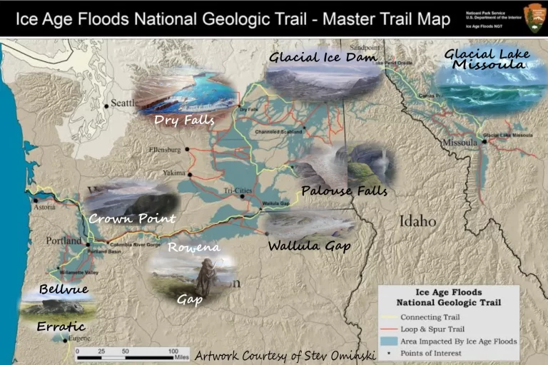

Prints available in IAFI Store.
Imagine the greatest floods on earth crashing across and sculpting the lands of the northwestern United States. This incredible true story is recorded in rock, sediments and spectacular landscapes that you can explore all along the Ice Age Floods National Geologic Trail.
At the end of the last Ice Age, 15,000 to 13,000 years ago, an ice dam in northern Idaho created Glacial Lake Missoula stretching 3,000 square miles around Missoula, Montana. The dam burst and released flood waters across central Washington and down the Columbia River to the Pacific Ocean. The Ice Age Floods forever changed the landscape of the Pacific Northwest.
Follow the Ice Age Floods National Geologic Trail from Clark Fork, Idaho, to Illwaco, Washington, and so many wondrous points in between!
The Ice Age Floods Institute has created various tools to better assist your Self-Guided Tours in this vast area:
ICE AGE FLOODS NATIONAL GEOLOGIC MAP
PLACES TO GO THINGS TO DO
INTERACTIVE MAP FIELD GUIDES
Guided Tours are often available through IAFI Chapters.

Prints available in IAFI Store.
Since at least the 1990’s, many people have worked toward the successful creation of an Ice Age Floods National Geologic Trail.
In 2001, the National Park Service completed a major Special Resource Study and submitted a report to Congress proposing that an Ice Age Floods National Geologic Trail be established.
The Ice Age Floods National Geologic Trail was finally officially established by Congress in 2010.

The Ice Age Floods National Geologic Trail is a network of marked touring routes extending across parts of Montana, Idaho, Washington, and Oregon, with several special interpretive centers located across the region.
The Ice Age Floods National Geologic Trail represents the largest, most systematic, and most cooperative effort yet to bring the dramatic story of the Ice Age Floods to the public’s attention.
It also has the potential to bring significant economic and cultural benefits to communities throughout the Pacific Northwest.
The Ice Age Floods National Geologic Trail is the result of nearly 30 years of a partnership between the IAFI and the National Parks Service (NPS) and hard work by many people.
Since IAFI was formed in 1995, we have worked with the National Park Service to create, build support for, and expand recognition of the Ice Age Floods National Geologic Trail.
We are proud to be partners with the NPS and other state, local and corporate partners in these efforts.

Welcome!
We are so glad you’re joining us on this journey of discovery!
One of our goals is to help students develop an appreciation of our unique Northwest Landscapes and the immense area affected by the Ice Age Floods.
The Ice Age Floods Institute and the National Park Service are happy to share a Curriculum Guide for teaching about the Ice Age Floods called
“Investigating Ice Age Floods”.
This Educator’s Guide provides adaptable lesson plans and other resources to help you engage students with the forces that created our dramatic landscapes.
This includes the most recent Ice Age Floods, some 18,000 to 15,000 years ago, which crossed Montana, Idaho, Washington, and Oregon, as well as the forces that exposed the rocks they eroded and more.
Students experiment with scientific phenomena, ask questions, analyze and interpret data, construct explanations, engage in argument from evidence, and obtain, evaluate and communicate information.

In short, they get to be scientists as they explore the awe-inspiring phenomena of our Northwest Landscapes and the processes that created them through hands-on investigations, field studies, and other engaging projects.