Bitterroot Valley Glacial Erratics
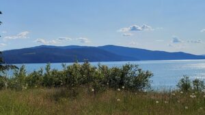
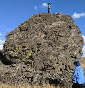
Two glacial erratics in the Bitterroot Valley, the Lone Rock School erratic and the Rome Lane erratic, were deposited during the last high stand of Lake Missoula about 13,000 years ago. Both these glacial erratics are easy to visit. At the extreme Southern end of the Bitterroot Valley is beautiful Lake Como named after its Italian alpine counter part by Father Ravalli a Jesuit Black Robe tasked with bringing literacy and Jesus to the native Salish people in 1845 via St Mary’s Mission in nearby Stevensville. Lake Como is a beautiful place for lunch and a hike/bike on the trail around lake including a beautiful waterfall a the head of the lake. Several mountain glaciers coalesced here and neighboring drainage to make the largest mass of ice calving into the lake south of the Flathead lobe of the Cordilleran ice sheet at Polson. This mass exited the mountains, floated into and calved into Glacial Lake Missoula. This was the primary iceberg generator for the Bitterroot Valley. As they floated out into the lake and melted they dropped large rocks called erratic onto the lake floor, which is now the surface of the valley. Lone Rock School Erratic The easiest one to find is the Lone Rock School erratic. From Stevensville, proceed north on the Eastside Highway, county road 269, to the junction with county road 268, turn right. Follow county road 268 until you reach the Lone Rock School on your left; the erratic is the large boulder in front of the south side of the school, and behind the fence (see map below). The Lone Rock School erratic is 69” tall, 58” wide, 85” long, and weighs in at about 8.5 metric tons or about 18,700 lbs. This large erratic is a type of granite called quartz monzonite. The minerals that make up this rock type are, in order of abundance, plagioclase (calcium and/or sodium rich) feldspar, orthoclase (potassium rich) feldspar, biotite (dark mica), and quartz. If you look closely you will see that the quartz typically stands out in relief with respect to the other minerals and that its surface has been polished to a smooth finish. This is the result of dense glacial ice grinding over the surface of the rock. Rome Lane Erratic The Rome Lane erratic measures 47” tall, 117” long, 96” wide, and weighs in at about 13 metric tons or about 28,600 lbs. The Rome Lane erratic is almost identical to the Lone Rock School erratic; it to is quartz monzonite granite with approximately the same minerals and mineral proportions. The observation that both erratics are of similar rock type suggests that they came from a similar source region. There are sources of quartz monzonite granite in both the Sapphire and Bitterroot Mountains, which is the source of these erratics? Since we know that the erratics were carried to the shores of glacial Lake Missoula by glaciers, we can rule out the Sapphires as a possible source because we know that no glaciers in the Sapphire Mountains ever reached the shores of Lake Missoula. So, the erratics had to come from the Bitterroot Mountains where the quartz monzonite granite lies anywhere between 5 and 20 miles from the ancient shoreline of Lake Missoula. That means glaciers carried the erratics for distances of up to 20 miles (32.2 km) before reaching the shores of glacial Lake Missoula. Which at an average velocity of 5 meters per day (normal for most valley glaciers with the exception of rare bursts in velocity up to 75 meters per day) would take about 18 years. Which Erratic is Oldest? The quartz grains on the surfaces of the Rome Lane erratic are polished to a smooth shine and stand out in relief above the other minerals, similar to the Lone Rock School erratic. However, the quartz grains exposed on the top surface of the Rome Lane erratic seem to exhibit higher relief than the quartz grains exposed on any other side of the Rome Lane erratic and/or the top surface of the Lone Rock School erratic. Why is this? Rainwater is slightly acidic and acidic fluids can break down some minerals, such as feldspar, and turn them into clay. Quartz, however, is very resistant to acidic fluids and as a result takes longer to break down or weather. It is this difference in weathering rates between feldspar and quartz that causes the quartz grains to stand higher than the feldspar grains. So, based on this relationship we can say that the greater the relief between quartz and feldspar on a rock surface, the longer that surface has been exposed to the elements i.e. rain and wind. With that in mind, which erratic’s top surface has been exposed longer? If you answered Lone Rock, you are correct. As it turns out the Lone Rock School erratic was dug up and moved from its original location, about ¾ of a mile to the south of where it sits today, to commemorate the Lone Rock Schools’ centennial in 1985, in fact upon its excavation portions of the erratic broke off and remain buried. So what is the top surface of the Lone Rock School erratic today may well not have been the top surface before 1985, and our mineral weathering hypothesis fits the facts.